Sayre Report - Hazard Mitigation Web Portal - State of California
Sayre Report - Hazard Mitigation Web Portal - State of California
Sayre Report - Hazard Mitigation Web Portal - State of California

Create successful ePaper yourself
Turn your PDF publications into a flip-book with our unique Google optimized e-Paper software.
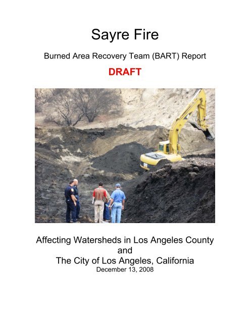
<strong>Sayre</strong> Fire<br />
Burned Area Recovery Team (BART) <strong>Report</strong><br />
DRAFT<br />
Affecting Watersheds in Los Angeles County<br />
and<br />
The City <strong>of</strong> Los Angeles, <strong>California</strong><br />
December 13, 2008
TABLE OF CONTENTS<br />
Disclaimer<br />
Executive Summary<br />
Team Members<br />
Contacts List<br />
Special Acknowledgment<br />
Specialist <strong>Report</strong>s Findings Summary<br />
Geology<br />
Hydrology<br />
Soils<br />
Water Quality<br />
Structural Engineering<br />
Forestry<br />
Wildlife Biology<br />
Botany<br />
Public Assistance<br />
Specialist <strong>Report</strong>s<br />
Geology<br />
Hydrology<br />
Soils<br />
Water Quality<br />
Structural Engineering<br />
Forestry<br />
Wildlife Biology<br />
Botany<br />
Public Assistance<br />
LIST OF APPENDICES<br />
Appendix 1<br />
Appendix 2<br />
Appendix 3<br />
Appendix 4<br />
Appendix 5<br />
Appendix 6<br />
Values at Risk Summary<br />
Burn Soil Severity Map<br />
Land Ownership/General Location and Index Map<br />
Hydrologic Sub Areas<br />
Drainage Areas and Debris Basin Map<br />
Risk to Lives and Property Map Index
Appendix 7 Values at Risk Site Map-Area 1<br />
Appendix 8 Values at Risk Site Map-Area 2<br />
Appendix 9 Values at Risk Site Map-Area 3<br />
Appendix 10 Values at Risk Site Map-Area 4a/4b<br />
Appendix 11 Wildlife Corridor Map<br />
Appendix 12 Fire History 1990-2008 Map<br />
Appendix 13 CNDDB List <strong>of</strong> <strong>California</strong> Terrestrial Natural Communities<br />
Appendix 14 Representative Photos <strong>of</strong> Values at Risk<br />
LIST OF FIGURES<br />
Figure 1<br />
Figure 2<br />
Figure 3<br />
Figure 4<br />
Figure 5<br />
Regional Geologic Map<br />
Vegetation Burn Severity (is soils document)<br />
Dozer Lines near Santa Clara Truck Trail<br />
Dozer Lines near Placerita Canyon<br />
Fire Suppression Line Eastern Placerita Canyon and Sand Canyon<br />
LIST OF TABLES<br />
Table 1<br />
Table 2<br />
Table 3<br />
Table 4<br />
Table 5<br />
Table 6<br />
Table 7<br />
Table 8<br />
Table 9<br />
Burn Severity by Hydrologic Sub Areas<br />
Burn Severity Summary for Drainage Areas<br />
Peak Flows Increase for 2, 5, and 10 Year storm events<br />
Sediment Load on Debris Basin<br />
Wildlife Risks within the Fire Perimeter<br />
Wildlife Risks immediately adjacent to the Fire Perimeter<br />
Vegetation Communities within the Fire Impact Zone<br />
Threatened and Endangered Plant List and General Location<br />
Invasive Weed list in and adjacent to the Fire
DISCLAIMER<br />
The scope <strong>of</strong> the assessment and the information contained in this report should not be<br />
construed to be either comprehensive or conclusive, or to address all possible impacts<br />
that might be ascribed to the fire effect. Post fire effects in each area are unique and<br />
subject to a variety <strong>of</strong> physical and climatic factors which cannot be accurately<br />
predicted. The information in this report was developed from cursory field examination<br />
by licensed resource pr<strong>of</strong>essionals and should be viewed in conjunction with other<br />
relevant sources <strong>of</strong> information. Neither the <strong>State</strong> <strong>of</strong> <strong>California</strong> nor any Agency or<br />
Department participating as a member <strong>of</strong> the Burn Area Response Team (BART)<br />
makes any warranty, express or implied, nor assume any legal liability for the<br />
information disclosed herein.<br />
EXECUTIVE SUMMARY<br />
SAYRE FIRE CA-LFD-1460<br />
Affecting watersheds in the County and City <strong>of</strong> Los Angeles, <strong>California</strong><br />
Introduction<br />
An initial Burned Area Recovery Team (BART) has been deployed to the Los Angeles<br />
County area to evaluate Values at Risk in the affected burn area <strong>of</strong> the <strong>Sayre</strong> Fire. The<br />
BART has three key objectives:<br />
Post-fire watershed assessment and recovery operations are conducted to:<br />
• Identify on-site and downstream threats to public health or safety from landslides,<br />
mudslides, debris torrents, floods, road hazards, and other fire related problems.<br />
• Identify threats to watershed resources, including: excessive erosion; impaired<br />
water quality; threats to wildlife, fisheries, and botanical values; and cultural<br />
resources.<br />
• Determine measures needed to prevent or mitigate identified threats.<br />
The <strong>Sayre</strong> Fire began on November 14, 2008 burning approximately 11,262 acres as a<br />
wind-driven fire before being declared contained on November 21, 2008. The fire<br />
burned north <strong>of</strong> the I-210 freeway in the foothills north <strong>of</strong> the Sylmar and Granda Hills<br />
areas <strong>of</strong> the City <strong>of</strong> Los Angeles. The northwest trending Golden <strong>State</strong> Freeway,<br />
Interstate 5, divides the <strong>Sayre</strong> burn area into that portion above the Granada Hills in the<br />
southern flank foothills <strong>of</strong> the eastern Santa Susana Mountains west <strong>of</strong> the freeway and<br />
that portion above Sylmar in the western San Gabriel Mountains, on the east side <strong>of</strong> the<br />
freeway. Of the total area burned, about 50% (5,668 acres) are lands owned by the<br />
U.S. Forest Service, administered by the Angeles National Forest; the remainder <strong>of</strong> the<br />
area is comprised <strong>of</strong> approximately 3,000 acres (26%) <strong>of</strong> <strong>State</strong> <strong>of</strong> <strong>California</strong>, Direct
Protection Area (DPA), and 2,594 acres (24%) within local jurisdictions <strong>of</strong> the County<br />
and City <strong>of</strong> Los Angeles.<br />
The <strong>Sayre</strong> Fire was bordered on the east by the recent Marek Fire and along the west<br />
by the Sesnon Fire. These two fires occurred in October <strong>of</strong> 2008. It should be noted that<br />
the three fires combined to create a fire complex that broadens the scope <strong>of</strong> identified<br />
values at risk downslope <strong>of</strong> the San Gabriel and nearby mountains. The scope <strong>of</strong> this<br />
BART report is focused on the aftermath <strong>of</strong> the <strong>Sayre</strong> Fire.<br />
The recommendations found in this report are to be used as a guideline for possible<br />
mitigation to decrease to risk <strong>of</strong> damages to life and property. It is an initial assessment<br />
to disclose values at risk (VARs). The treatments fall into one <strong>of</strong> two broad categories.<br />
Those treatments which can be considered temporary (short-term) measures designed<br />
to be quickly and relatively inexpensively implemented; and long-term treatments<br />
designed to facilitate the recovery <strong>of</strong> the watershed at an accelerated pace while<br />
concurrently minimizing the exposure <strong>of</strong> the VARs to the threats identified.<br />
Watershed Evaluation<br />
The burn area falls within the Ventura-San Gabriel Coastal Basin <strong>of</strong> Southern <strong>California</strong><br />
Coastal Sub-region and covers portions <strong>of</strong> the following three hydrologic sub-areas<br />
(HSAs): Sylmar, Bull Canyon, and Eastern. Please see Appendix 2 for Burn Severity by<br />
the Hydrologic Sub Areas. All <strong>of</strong> the drainages affected by the <strong>Sayre</strong> Fire in Los<br />
Angeles River watershed flow south and eventually drain into Los Angeles River. Los<br />
Angeles County Department <strong>of</strong> Public Works (LACDPW) and City constructed large<br />
debris basins and dams at the mouth <strong>of</strong> several major canyons to control debris flow<br />
and sediment laden flooding.<br />
There are 8 large debris basins with engineered spillways associated with the 8 major<br />
canyons starting west from Stetson Canyon to the east at Pacoima Dam. In addition to<br />
these major drainages, there are a number <strong>of</strong> smaller drainages on the south edge <strong>of</strong><br />
the burned area that are not under the control <strong>of</strong> any major debris basin. The estimated<br />
sediment loads on all debris basins are comparable to their maximum capacity; at<br />
Wilson, May-1 and Sombrero debris basins, the load would exceed their maximum<br />
capacity with a 2% probability. It is important to clean the debris basins so that the full<br />
capacity <strong>of</strong> the debris basins would be immediately available to hold the increased<br />
amount <strong>of</strong> debris. LACDPW has been proactive in rapid cleanout and maintenance <strong>of</strong><br />
several debris basins affected by the fire. The areas that were field reviewed by the<br />
BART include Loop, Wilson, Hog, Sombrero, Elsmere and Bee Canyons, as well as the<br />
area around the Pacoima Reservoir.
Values at Risk<br />
The principal concern with the <strong>Sayre</strong> Fire is loss <strong>of</strong> human life and property due to an<br />
increase in the potential for in-channel floods, hyper-concentrated floods, debris<br />
torrents, mud sliding, and debris flows. Houses and communities near or within stream<br />
channels near Sylmar and below Pacoima Dam have been specifically identified where<br />
significant in-channel floods, hyper-concentrated floods, debris torrents, mud sliding and<br />
debris flows are possible. In addition, possible loss <strong>of</strong> life resulting from localized debris<br />
sliding, debris flows, and sediment laden floods onto individual homes beyond the areas<br />
described previously is also possible.<br />
For locations <strong>of</strong> Values at Risk for human life and property see Risk to Lives and<br />
Property Map (Appendix 6)<br />
A. Loss <strong>of</strong> Human Life and Property<br />
The Pacoima Dam has high risk <strong>of</strong> sediment build up. A significant debris flow event<br />
may cause clogging <strong>of</strong> the water intake/outlet structure and failure <strong>of</strong> valves. The Dam<br />
could become inoperable with uncontrolled water release leading to water overtopping<br />
<strong>of</strong> the Dam. Uncontrolled water release from the dam could have catastrophic impacts<br />
to human lives and properties downstream. It is highly recommended that early warning<br />
systems, if not already in place, be installed to warn the down steam residents <strong>of</strong> the<br />
potential for catastrophic flooding if these conditions do occur. It is also recommended<br />
that responsible agencies have a dam safety specialist and technical experts evaluate<br />
the condition <strong>of</strong> the dam, and prepare and implement a plan to address this issue.<br />
The Pacoima Dam Office is situated at the base <strong>of</strong> a steep rock slope and is already<br />
subject to a significant rock fall hazard. The hazards to lives and property at this facility<br />
are present as evidenced by the presence <strong>of</strong> a masonry retaining wall and a chain link<br />
fence that have been placed near the toe <strong>of</strong> the slope to partially mitigate the rock fall<br />
hazards. This hazard potential has been increased due to the <strong>Sayre</strong> fire from denuding<br />
upslope areas <strong>of</strong> vegetation and the thermal effects <strong>of</strong> fire on exposed rock faces.<br />
Recent rock fall debris, dry ravel, burnt timber lagging, and an impact scar to the<br />
masonry wall were observed during the BART reconnaissance <strong>of</strong> this site.<br />
In addition, houses and other features may be affected by local floods and slope failures<br />
as identified below. The magnitude <strong>of</strong> post-fire damage will be determined by the<br />
intensity and duration <strong>of</strong> rainstorms that impact the area. VARs near or within stream<br />
channels and those located adjacent to the basin spillways that outlet to the streets may<br />
be affected significantly. A specific site was observed at Gavina access road where the<br />
culverted road crossing was found to be obstructed by debris and sediment. The culvert<br />
at the road crossing is already at two-thirds <strong>of</strong> its design capacity. Flooding is likely to<br />
the neighborhood downslope <strong>of</strong> the culvert if it is not cleaned and maintained before<br />
significant storm events occur.
B. Threats to Wildlife and Botanical Values<br />
Rare plant and natural community locations from the <strong>California</strong> Natural Diversity Data<br />
Base (CNDDB, 2008) were overlain with fire burn severity data and mapped bulldozer<br />
fireline location information to identify potential areas <strong>of</strong> impact from fire suppression<br />
and repair activities. This information was used as a cursory evaluation <strong>of</strong> impacts to<br />
sensitive species and natural wildlife/plant communities. Burn Area Reflectance<br />
Classification (BARC) maps did not correspond well with Burn Severity Maps and<br />
therefore were not relied upon by the BART for this analysis).<br />
Eight rare plant species and five sensitive plant communities have been reported to<br />
occur in the region <strong>of</strong> the <strong>Sayre</strong> Fire area, although two <strong>of</strong> them are not known from<br />
<strong>State</strong> Responsibility Lands (Table 8). As a result <strong>of</strong> the fire and the impacts from the<br />
loss <strong>of</strong> vegetation and burn severity evaluation biological and botanical habitat is at an<br />
increased risk to the threat <strong>of</strong> flooding, rockfall, debris torrents, mud sliding and debris<br />
flows, sedimentation, and chemical pollution. Fire Suppression activities (e.g. “dozer<br />
lines”) have also contributed to the current risk to biological and, botanical species.<br />
The risk is greatest in the vicinity <strong>of</strong> the Vernal Pools near O’Melveny Park where the<br />
Sesnon Fire met up with the <strong>Sayre</strong> Fire. The potential for direct mortality to sensitive<br />
and endangered species as well as dozer lines adjacent to the vernal pool that borders<br />
these two fires may experience adverse impacts due to erosion and sediment deposits.<br />
Upland wildlife species may sustain the greatest impacts from this fire. The San Diego<br />
coast horned lizard, silvery legless lizard, burrowing owl, and San Diego desert wood rat<br />
are <strong>State</strong> Species <strong>of</strong> Concern, (CNDDB 2008) with occurrences in the general vicinity <strong>of</strong><br />
the <strong>Sayre</strong> Fire. Populations in this region inhabit sandy washes within chaparral, coastal<br />
sage scrub communities and chaparral habitats. Sedimentation and debris flow,<br />
continued or increased habitat disturbances from public use and habitat conversion are<br />
all possible factors that could result in habitat degradation or loss.<br />
C. Threats to Public Safety and Property from <strong>Hazard</strong> Trees<br />
An assessment <strong>of</strong> the fire area revealed that native species, adapted to the fire regimes,<br />
will likely survive intact or resprout quickly. Those species planted as ornamentals that<br />
are not adapted to the local environment are more susceptible to mortality caused by<br />
the fire and subsequent attacks from insects and pathogens.<br />
The principal values at risk from fire damages trees are to people and property. Fire<br />
killed or damaged trees can fall or drop limbs or uproot either without warning or during<br />
the frequent high wind events experienced in this area. During field evaluations, it was<br />
discovered that many hazard trees were being treated by local agencies. More trees<br />
can be expected to die from fire caused mortality within the next four to five years.
D. Threats to Cultural Resources<br />
As a result <strong>of</strong> the fire and the impacts from the loss <strong>of</strong> vegetation and burn severity<br />
evaluation <strong>of</strong> watersheds natural and cultural resources are at an increased risk to the<br />
threat <strong>of</strong> flooding, rockfall, debris torrents, mud sliding and debris flows. Additionally,<br />
there is an increased risk <strong>of</strong> the exposure <strong>of</strong> cultural sites as a result <strong>of</strong> the fire or the<br />
associated suppression activities removing protective vegetative cover. Since the BART<br />
did not have an archeologist available for the field assessment team. Therefore, it is<br />
highly recommended that local administrators seek additional assistance to evaluate<br />
threats to cultural and prehistoric archaeological resources. In addition, it is<br />
recommended that an archaeologists work with the City and County <strong>of</strong> Los Angeles to<br />
develop avoidance mitigation measures to prevent harm to these valuable resources.<br />
Furthermore, reference should be made to the Angeles National Forest’s Burned Area<br />
Emergency Response Team’s (BAER’s) Cultural Specialist <strong>Report</strong> to assist in<br />
identifying these resources in the region. The risk from the fire is greatest to those<br />
cultural sites that have been exposed as a result <strong>of</strong> the fire or the associated<br />
suppression activities that could be vandalized or otherwise compromised.<br />
E. Soil Burn Severity<br />
Soil burn severity is the amount <strong>of</strong> heat that is released by a fire and how it affects other<br />
resources. Soil Burn Severity on the <strong>Sayre</strong> Fire has been determined to be as follows:<br />
High: 2% 225 acres<br />
Moderate: 60% 6757 acres<br />
Low: to unburned 38% 4279 acres<br />
F. Public Assistance<br />
The areas <strong>of</strong> interest with regards to Public Assistance are relatively confined to the<br />
debris basins, dams, mud flow protective measures, Olive View Hospital and damage to<br />
the Pacoima Dam. Also, any potential emergency protective measures that were put in<br />
place by the various City and County agencies within the 1810 DR incident period <strong>of</strong> 11-<br />
10-08 to 11-28-08.<br />
Summary<br />
The fire and the resultant impact to the VARs previously discussed have an increase<br />
risk for storm events to result in flooding, rockfall, debris torrents, mudsliding and debris<br />
flows. As storm intensity or duration rises, there will be an associated increased<br />
elevation in risk for the storm event to trigger flooding, mud sliding, debris torrents,<br />
debris flows, and sedimentation. The threat posed by flooding, mud sliding, debris<br />
torrents, and debris flows includes the loss <strong>of</strong> life and property. All imminent VARs<br />
identified herein could be adversely affected. In the cases mentioned where VARs are<br />
high, it is imperative to take precautionary actions to protect life and property,<br />
particularly with the approaching winter storms.
All VARs identified during the Scoping Mission on November 21 st and identified in the<br />
<strong>Sayre</strong> Fire Scoping <strong>Report</strong> were evaluated during in the <strong>Sayre</strong> Fire BART <strong>Report</strong>.
List <strong>of</strong> BART Team Members<br />
Debbie Carlisle, Engineer – Lead<br />
<strong>California</strong> Department <strong>of</strong> Water<br />
Resources<br />
901 P Street, Room 213B<br />
Sacramento, CA 95814<br />
Len Nielson, Safety Officer - Co-Lead<br />
<strong>California</strong> Department <strong>of</strong> Forestry and<br />
Fire Protection (CAL FIRE)<br />
118 S. Fortuna Blvd.<br />
Fortuna, CA 95540<br />
Kelly Schmoker M.S., Botanist<br />
<strong>California</strong> Department <strong>of</strong> Fish and Game<br />
4949 Viewridge Ave.<br />
San Diego, CA 92123<br />
Tim Smith, Public Assistance<br />
Office <strong>of</strong> Emergency Services<br />
3650 Shriever Avenue<br />
Mather, CA 95655<br />
Douglas Cook, Geologist<br />
<strong>California</strong> Department <strong>of</strong> Transportation<br />
Adam Deem, Forester Lead Trainee 5900 Folsom Blvd., Q3-28<br />
<strong>California</strong> Department <strong>of</strong> Forestry and Sacramento, CA 95819-4612<br />
Fire Protection (CAL FIRE)<br />
6105 Airport Road Dana Cole, Water Quality<br />
Redding, CA 96002-9422<br />
Region Water Quality Control Board<br />
320 West 4 th Street 2 nd Floor<br />
Thomas D. Bristow, Deputy Forester Los Angeles, CA 90013<br />
County <strong>of</strong> Los Angeles Fire Department<br />
12605 Osborne Street Stevenson Lim, Structural Enginee r<br />
Pacoima, CA 91331-2129<br />
<strong>California</strong> Department <strong>of</strong> Transportation<br />
100 South Main Street<br />
Wenhua Yu, Hydrologist Los Angeles, CA 90012<br />
<strong>California</strong> Department <strong>of</strong> Water<br />
Resources<br />
George Walintukan, GIS Specialist<br />
770 Fairmont Avenue, Suite 102 <strong>California</strong> Department <strong>of</strong> Transportation<br />
Glendale, CA 91203-1035 120 South Spring Street, MS 16<br />
Los Angeles, CA 90012<br />
Robert Fastenau, Soil Specialist<br />
<strong>California</strong> Department <strong>of</strong> Water<br />
Resources<br />
770 Fairmont Avenue, Suite 102<br />
Glendale, CA 91203-1035<br />
Office (818) 500-1645<br />
Terri Stewart, Supervising Biologist<br />
<strong>California</strong> Department <strong>of</strong> Fish and Game<br />
4949 Viewridge Avenue,<br />
San Diego, <strong>California</strong> 92123
<strong>Sayre</strong> Fire Contact List<br />
Katie VinZant, Botanist<br />
US Forest Service<br />
Angela Mendoza, Wildlife Biologist<br />
US Forest Service<br />
Kelli Brasket, Heritage<br />
US Forest Service<br />
Stanton Florea, Public Assistance<br />
US Forest Service<br />
Mike McIntyre, District Ranger<br />
US Forest Service<br />
Sherry Rollmon, Public Assistance<br />
Officer<br />
US Forest Service<br />
Paul Nguyen<br />
Natural Resources Conservation<br />
Service<br />
Jae Lee<br />
Natural Resources Conservation<br />
Service<br />
Kristeen Penrod, Conservation Director<br />
Natural Resources Conservation District<br />
Patricia Wood, Senior Civil Engineer<br />
LA County Dept <strong>of</strong> Public Works<br />
Mike Miranda<br />
LA County Dept <strong>of</strong> Public Works<br />
Tom Cotter<br />
Los Angeles City Public Works<br />
Bill Varley, Area Coordinator<br />
CA. Dept <strong>of</strong> Transportation<br />
Stephanie English, Community Services<br />
Liaison, LA County Fire<br />
John Knowell, Asst. Fire Chief<br />
LA City Fire Dept.<br />
Battalion 12<br />
Mark Stormes, Asst. Chief<br />
LA City Fire Dept.<br />
Mike Pakshita, Asst. Chief<br />
LA County Fire<br />
Frank Kyrsack, Sergeant<br />
LA City Mission Community Police<br />
Station<br />
Bob Ross, Facilities Manager<br />
Olive View Hospital<br />
Dash Stolarz<br />
Santa Monica Mountains Conservancy<br />
Scott Harris, Environmental Scientist<br />
CA. Dept. <strong>of</strong> Fish and Game<br />
Rebecca Barbozza, Wildlife Biologist<br />
CA. Dept. <strong>of</strong> Fish and Game<br />
Tim Hovey, Fisheries Biologist<br />
CA. Dept. <strong>of</strong> Fish and Game<br />
Esther Rubin, Ecologist<br />
Conservation Biology Institute<br />
Seth Riley, Wildlife Ecologist<br />
National Park Service<br />
Nathanial Cox, Park Ecologist<br />
Santa Susana Pass Historic <strong>State</strong><br />
Park<br />
Mikael Romich, Environmental<br />
Consultant<br />
Jones and Stokes
Special Acknowledgment<br />
The <strong>Sayre</strong> BART would like to extend a special acknowledgment to the Courtyard by<br />
Marriott Santa Clarita hotel for their assistance in providing <strong>State</strong> Rate rooms for the<br />
team members. Also, for extending their hospitality to include the use <strong>of</strong> a meeting room<br />
everyday for the team to meet to discuss the daily issues that arise during field<br />
investigations and report writing.
DRAFT TECHNICAL SPECIALIST’S SUMMARY<br />
Burn Area Recovery Team (BART)<br />
Engineering Geology<br />
The scope <strong>of</strong> the assessment and the information contained in this report should not be<br />
construed to be either comprehensive or conclusive, or to address all possible impacts<br />
that might be ascribed to the fire effect. Post fire effects in each area are unique and<br />
subject to a variety <strong>of</strong> physical and climatic factors which cannot be accurately<br />
predicted. The information in this report was developed from cursory field examination<br />
by licensed resource pr<strong>of</strong>essionals and should be viewed in conjunction with other<br />
relevant sources <strong>of</strong> information. Neither the <strong>State</strong> <strong>of</strong> <strong>California</strong> nor any Agency or<br />
Department participating as a member <strong>of</strong> the Burn Area Response Team (BART)<br />
makes any warranty, express or implied, nor assume any legal liability for the<br />
information disclosed herein.<br />
The most significant near term geologic threat to the burn area is an increased potential<br />
risk from rock falls, debris flows and mud torrents flowing down the slopes and canyon<br />
bottoms as a result <strong>of</strong> locally intense or seasonally sustained rain fall on the preexisting<br />
slope failures and fire denuded hillsides.<br />
Of the thirty four (34) at-risk sites identified by the BART survey, only 2 sites (Pacoima<br />
Dam <strong>of</strong>fice building and reservoir) were found at to be at potential geologic risk from<br />
rock fall and landslides, and 26 sites (primarily the Dam reservoir and other Debris<br />
Basins) from debris flow or mud torrent flood inundation. The remaining sites were<br />
evaluated to not have a significant geologic impact from the fire to the observed risk<br />
potential.<br />
The Pacoima Dam Office is situated near the toe <strong>of</strong> a steep rock slope and is already<br />
subject to a significant rock fall hazard. The rock fall hazard potential has been<br />
substantially increased due to the <strong>Sayre</strong> Fire from the denuding <strong>of</strong> the slope and<br />
thermal effects <strong>of</strong> the fire on the exposed rock face. Recent rock fall and dry ravel<br />
debris on the slopes and behind the walls, along with burnt timber lagging <strong>of</strong> several<br />
walls, and damage to the masonry wall were observed during the BART<br />
reconnaissance <strong>of</strong> the site.<br />
The Pacoima Dam reservoir pond is also already subject to significant rock fall and<br />
landslide hazards from the adjacent slope areas. This potential risk has become<br />
increased due to both the <strong>Sayre</strong> Fire on the western side and the Marek Fire on the<br />
eastern side <strong>of</strong> the reservoir due to the denuding <strong>of</strong> the slopes and an increased<br />
susceptibility <strong>of</strong> soil or rock movement due to rainfall events.
The VARs considered in this assessment include the possible loss <strong>of</strong> life and property<br />
due to landsliding, debris flow, rock fall, debris flow, mud torrents, and flooding from<br />
increased surface water run<strong>of</strong>f. In general, only 2 sites (Pacoima Dam Office Building<br />
and Reservoir) were found at risk from the direct geologic impacts <strong>of</strong> rock fall and<br />
slides, and 26 sites (chiefly the dam reservoir and debris basins) from debris flow or<br />
mud torrent flood inundation. The potential for these processes to be exacerbated by<br />
fire is primarily dependent upon burn severity and slope steepness, both <strong>of</strong> which are<br />
highly variable in the <strong>Sayre</strong> Fire area.<br />
Treatments to Mitigate the Emergency<br />
o<br />
o<br />
o<br />
Pacoima Dam Office Building<br />
• Mitigate rock fall to protect life and property.<br />
Pacoima Dam Reservoir<br />
• <strong>Mitigation</strong> <strong>of</strong> slopes is not considered economically feasible.<br />
• Restore and maintain reservoir capacity and function by removal <strong>of</strong><br />
sediment load.<br />
Other debris basins<br />
• <strong>Mitigation</strong> <strong>of</strong> the debris flow, mud torrents, flood waters into and<br />
overtopping the basins is paramount to reduce the potential loss <strong>of</strong><br />
property. This can be accomplished by monitoring and maintaining<br />
the debris basins. The potential loss <strong>of</strong> life is minimal due to the<br />
ability to evacuate when necessary by elevated public awareness<br />
and early warning <strong>of</strong> pending events.<br />
The site-specific observations included with the Technical Specialist Geology report<br />
should be considered in any emergency response plan develop by the local emergency<br />
agencies and stakeholders. Each area should undergo a more thorough analysis by a<br />
suitable licensed pr<strong>of</strong>essional to address the specific hazard(s).<br />
Hydrology<br />
The <strong>Sayre</strong> Fire consumed large areas <strong>of</strong> vegetative material and large woody debris in<br />
multiple watersheds. The Soils Burn Severity Map indicates that 24% <strong>of</strong> the area burned<br />
at a low level and 60% at moderate level and only less than 1% at high level. The<br />
hydrophobicity tests ranged from low to moderate with small patches <strong>of</strong> high confirming<br />
the burn severity map.<br />
Peak flows equivalent to 193% to 243% pre-fire peak flow for a 2- year storm event<br />
were estimated on drainage areas <strong>of</strong> major the debris basins and for the Pacoima<br />
reservoir. The sediment loads on all debris basins were estimated to be comparable to<br />
their maximum capacity; at Wilson, May-1 and Sombrero debris basins, there is a 2-5%<br />
probability that their maximum capacity would be exceeded.<br />
Evaluations <strong>of</strong> the major debris basins in the area indicate some initial signs <strong>of</strong> sediment<br />
build up. The Pacoima reservoir has high risk <strong>of</strong> sediment build up, and the inlet/outlet
works at Pacoima dam may be clogged and fail to release water in the event <strong>of</strong> a major<br />
storm event.<br />
Multiple residential catchment basins and small drainage areas behind a number <strong>of</strong><br />
homes were evaluated with minor erosion sediment observed from recent storm events;<br />
however, a number <strong>of</strong> private and commercial buildings have risk <strong>of</strong> damage from<br />
sediments, debris flow, and flooding.<br />
The VARs considered in this assessment include the possible loss <strong>of</strong> life and property<br />
due to land-sliding, debris flow, rock fall, debris torrents, and flooding from increased<br />
surface water run<strong>of</strong>f. The sites posing such imminent threats require immediate action<br />
to reduce their risk. It is important to cleanup the debris basins so that the full capacity<br />
would be immediately available to hold the increased amount <strong>of</strong> debris. Responsible<br />
agencies should have dam safety specialist and experts evaluate the condition <strong>of</strong> the<br />
Pacoima dam, and prepare and implement a plan to resolve the post-fire sediment<br />
issue.<br />
Treatments to Mitigate the Emergency<br />
o Implement erosion control Best Management Practices (BMPs) with the<br />
objective <strong>of</strong> protecting life property and natural resources (including cultural<br />
resources):<br />
• Clean up sediment at major debris basins, and repair and<br />
maintain outlet structure.<br />
• Installation <strong>of</strong> silt fence, fiber rolls, debris barriers, construction<br />
<strong>of</strong> V-ditches along the upper slope <strong>of</strong> homes.<br />
• Monitor before and after rain events for debris flow on all<br />
resources listed<br />
• Initiate/re-evaluate ALERT Early warning systems/Evacuation<br />
plans.<br />
Expect higher than normal flows with possible debris flow in all rain events. The higher<br />
the rainfall intensity the higher the risk for significant severe flooding and debris flow<br />
throughout all burned areas and potentially miles downstream <strong>of</strong> the damaged<br />
watersheds.<br />
Soils<br />
This assessment evaluated the soils located in <strong>State</strong> and private lands. Potential<br />
values at risk from debris flows, mudslides and flooding include: human lives, homes,<br />
water supplies, drainage crossings, roads, bridges and parks.<br />
The principal concern with the <strong>Sayre</strong> Fire is an increase in the potential for erosion<br />
caused by increased run<strong>of</strong>f and decrease in infiltration. The Soils Burn Severity Map<br />
indicates that 84% <strong>of</strong> the area burned at a low to moderate level. The hydrophobicity
tests ranged from low to moderate with small patches <strong>of</strong> high confirming the burn<br />
severity map. The soils in the <strong>Sayre</strong> Fire are in the loam category and have a<br />
moderately high susceptibility to erosion and will produce moderate sediment flows.<br />
Evaluations <strong>of</strong> the Los Angeles County Public Works Debris Basins indicate some initial<br />
signs <strong>of</strong> increased sediment load. The access road at the Pacoima Reservoir was<br />
reported to have had up to 3 feet <strong>of</strong> erosion sediment blocking the main access to the<br />
Dam. The box culvert under Gavina Avenue was observed to have up to two-feet <strong>of</strong><br />
sediment, but could easily become completely blocked. Multiple residential debris<br />
basins and small drainage areas behind a number <strong>of</strong> homes were evaluated with minor<br />
to no erosion sediment observed from recent storm events.<br />
Mulching, fiber rolls, and straw bales with silt fencing may be used to prevent erosion at<br />
high value sites or to prevent run<strong>of</strong>f damage to specific roads or site improvements.<br />
Timely maintenance after storm events on road drainage crossings, culverts, and catch<br />
basins can help keep access open and homes safe. it is recommended that signs be<br />
posted to deter activities that would increase erosion damage. Road access could also<br />
be limited by maintaining locked gates at entrance points to major roads.<br />
Water Quality<br />
Areas <strong>of</strong> concern are residential areas immediately downstream <strong>of</strong> the burned area,<br />
especially below culverts and drainages. The values at risk are: possible loss <strong>of</strong> life and<br />
property due to flooding caused by blockages, debris flows, slope- and water-generated<br />
landslides, rock fall, associated hazards, and impacts to water quality.<br />
The Oakridge Mobile Home Park, which is located at the base <strong>of</strong> the foothills in Sylmar,<br />
<strong>California</strong>, consumed approximately 480 mobile homes in a catastrophic fire event. It is<br />
assumed that because the structures were lost, are on a slope, and that burned manmade<br />
materials remain, the potential for these materials to be mobilized is increased<br />
during a rain event. If that is the case, there is potential for impact to waters <strong>of</strong> the state<br />
or U.S. If the drainage from Oakridge (if the burned materials remain) is not diverted,<br />
contained, or sent to a water treatment facility. It is also expected that increased<br />
turbidity downstream will occur as a result <strong>of</strong> increase in sediment and debris coming<br />
from the burned <strong>Sayre</strong> Fire area.<br />
Structural Engineering<br />
Multiple residential structures were damaged or destroyed by the <strong>Sayre</strong> Fire. Seven key<br />
infrastructure debris basins need remediation, one county agency bridge needs repair,<br />
one equipment shed was destroyed, numerous Metal Beam Guard Railing (MBGR)<br />
timber posts along Fwy. 210 North and South bound Connector to Interstate 5 do<br />
require replacement. Four major bridge structures (Glenoaks, Yarnell, and Fwy 210<br />
North and South bound to Interstate 5) close to the vicinity <strong>of</strong> the fire area have not<br />
suffered any structure damage.
Evaluations <strong>of</strong> the Los Angeles County Public Works Debris Basins indicate some initial<br />
signs <strong>of</strong> increased sediment load. Lives and property are potentially at risk at sites in<br />
flood prone areas, or on roads where flash flooding may cause washouts due to run<strong>of</strong>f<br />
in excess <strong>of</strong> culvert capacity. Regional water quality supply is potentially at risk from<br />
loss <strong>of</strong> water control on hill slopes.<br />
A design check, field inspection, clearing channel obstructions and increasing basin<br />
capacities are recommended to assure these facilities will accommodate the excess<br />
flows created by additional mud and debris flow caused by the recent fire. Post mud<br />
slide and flood warning signs, and establish evacuation plans for property owners within<br />
and downstream <strong>of</strong> these basins. A detailed structural inspection, structural analysis<br />
and a repair design plan for the bridge and the equipment shed at the Pacoima Dam<br />
facility should be prepared by an Engineer and to be submitted to Los Angeles County<br />
agency for consideration. Finally, replace and repair fire damaged timber posts <strong>of</strong> the<br />
metal beam guard railing along the North and South Bound Freeway <strong>of</strong> the 210 to the<br />
Interstate 5 Freeway.<br />
Forestry<br />
Most <strong>of</strong> the fire area is generally considered chaparral and coastal sage scrub, tree<br />
species include: Coast Live Oak, Scrub Oak, <strong>California</strong> Sycamore and Southern<br />
<strong>California</strong> Black Walnut existing in lower drainages, and various debris basins.<br />
Around the Olive View Hospital and homes within the Wildland Urban Interface (WUI), a<br />
variety <strong>of</strong> species including Eucalyptus, Aleppo Pine and Canary Island Pine are<br />
planted as ornamentals. Overall burn intensities are moderate to low. Areas with native<br />
tree cover were mostly low, being subject to under burning with some group and<br />
individual tree torching.<br />
Chapparal species and oak’s native to this area are expected to recover from the fire<br />
damage, either by suffering no significant harm or by resprouting. Non native species<br />
and those not accustomed to fire are at an increased risk <strong>of</strong> fire-caused mortality.<br />
Additionally, fire damaged trees are at increased risk to beetle infestation and tree<br />
disease.<br />
Values at Risk from trees damaged by fire principally include people and property, with<br />
some increased risk to natural resources. Risk to people and property would be in the<br />
form <strong>of</strong> damage and/or injury resulting from trees or limbs dropping either without<br />
warming or during a wind or rain event. Damage to life property and natural resources<br />
may also occur when downed trees combine with debris flows and landslides.<br />
<strong>Mitigation</strong> to reduce the risks to live, property and natural resources are already being<br />
observed within the fire area. It is recommended that licensed pr<strong>of</strong>essionals be<br />
employed to evaluate individual hazards and propose mitigation.
Wildlife Biology<br />
Habitats within the fire perimeter burned at predominantly low to moderate severity.<br />
Although areas <strong>of</strong> high severity were observed in most drainages, the broadest expanse<br />
<strong>of</strong> habitat that consistently burned with moderate severity occurred in the Elsmere<br />
Canyon area.<br />
Fires affect wildlife primarily through changes in habitat. Although individuals may have<br />
perished during the fire event, most wildlife populations should re-colonize the area as<br />
habitat recovers.<br />
Habitats impacted by frequent fires are at risk <strong>of</strong> type-conversion, which may reduce the<br />
possibility <strong>of</strong> full recovery to pre-fire habitat condition. Post fire sedimentation in riparian<br />
systems also poses a significant risk to sensitive wildlife species. Several species may<br />
be at risk from long-term displacement or extirpation.<br />
Treatments to Mitigate the Emergency<br />
o Implement appropriate BMPs upstream <strong>of</strong> sensitive riparian habitats to<br />
minimize sediment load.<br />
o Conduct post-fire surveys in riparian zones to detect and immediately<br />
eradicate non-native species (e.g. arundo).<br />
o Conduct post-fire surveys to assess wildlife populations and habitat<br />
recovery.<br />
o Conduct long-term monitoring <strong>of</strong> key species to document population<br />
trends.<br />
o Avoid livestock grazing in burned areas until at least the 2009-2010<br />
growing season.<br />
o Coordinate with local agency representatives prior to and during<br />
maintenance activities to avoid, minimize, and mitigate additional impacts<br />
to species, particularly along riparian zones.<br />
Treatment objectives are to protect rare plants and rare natural communities from<br />
human-caused disturbance, to promote native plant re-colonization <strong>of</strong> burned areas and<br />
dozer lines, to curtail invasive weed infestations in their incipient stages, and to avoid<br />
spreading invasive weeds into currently unoccupied areas.<br />
Botany<br />
Botanical values including rare plant species and natural communities were identified as<br />
being at-risk within the fire area. Rare plants and natural communities should recover<br />
from the fires naturally. Human activities post-fire present the greatest potential threat<br />
due to the potential for to damaging rare plants, inhibiting native plant regeneration,<br />
introducing invasive weeds, and type conversion <strong>of</strong> shrublands and oak woodlands to<br />
non-native annual grassland dominant systems due to increased fire frequency.
Botanical resource emergencies fall into three major categories: 1) threats to rare plants<br />
from fire and implemented post-fire treatments, 2) loss <strong>of</strong> natural community integrity<br />
from invasive weeds and post-fire treatments that inhibit the growth <strong>of</strong> native plants and<br />
promote the establishment <strong>of</strong> non-native weedy species, and 3) type conversion <strong>of</strong><br />
shrublands and oak woodlands to non-native species due to increased fire frequency<br />
and spread <strong>of</strong> non-native weedy species.<br />
Treatments to Mitigate the Emergency<br />
Treatment Types<br />
o<br />
o<br />
o<br />
Dozer line remediation<br />
• Restoration, invasive species suppression, and monitoring.<br />
Minimizing intervention and disturbance<br />
• Close burn areas to public access for at least three (3) years<br />
Restoration <strong>of</strong> sensitive species habitat in disturbed and high intensity<br />
burn areas.<br />
Treatment objectives are to protect rare plants and rare natural communities from<br />
human-caused disturbance, to promote native plant re-colonization <strong>of</strong> burned areas and<br />
dozer lines, to curtail invasive weed infestations in their incipient stages, and to avoid<br />
spreading invasive weeds into currently unoccupied areas.<br />
Recommended treatments to mitigate the emergency include pre-activity surveys prior<br />
to ground disturbance in known rare plant habitat, avoiding seeding and mulching,<br />
monitoring for type conversion <strong>of</strong> native vegetation communities, and invasive weed<br />
surveys in key areas with prompt weed control.<br />
The greatest threat to rare plants and natural communities is related to human-caused<br />
disturbance post-fire and the affect <strong>of</strong> high frequency fires on the native habitat which<br />
contributing to type conversion.<br />
Public Assistance<br />
Within the <strong>Sayre</strong> Fire area flood control basins could pose a moderate risk from post fire<br />
erosion, flash flooding and massive debris accumulation at basins. The BART<br />
recommends a design check and field inspection to assure these facilities will<br />
accommodate the excess flows created by additional mud and debris flow caused by<br />
the recent fire. Clearing channel obstructions and increasing the basin capacity may<br />
help mitigate the effects <strong>of</strong> accelerated storm flows and sedimentation to property. Post<br />
mud slide and flood warning signs and establish evacuation plans. Increase awareness<br />
<strong>of</strong> the potential storms flows to the property owners.<br />
In addition to the above listed items, lives and property are potentially at risk at sites in<br />
flood prone areas, or on roads where flash flooding causes washouts due to run<strong>of</strong>f in<br />
excess <strong>of</strong> culvert capacity. In this area, known for frequent high winds, additional<br />
hazards can be damaged trees, dead trees, and limbs along major street corridors or
hiking and equestrian trails. Regional water supply is potentially at risk from loss <strong>of</strong><br />
vegetation on hill slopes. The Los Angeles County Public Works is currently working on<br />
various basins to remove the silt and debris. Several basins have had a significant<br />
increase in sediment and debris from a recent storm.<br />
The Pacoima Dam at the Los Angeles county maintenance yard’s bridge (15ft x 30ft<br />
steel frame “5 ton limit”) was burned. This bridge is one ingress and egress route<br />
between the maintenance yard and the Pacoima trail road. The bridge substructure and<br />
two abutments appeared to be in good condition. The Hoist House is concrete masonry<br />
with a metal corrugated ro<strong>of</strong> building (10ft x 12ft) that housed the engine and<br />
transmission cables located at the base <strong>of</strong> the Pacoima Dam. The house needs to be<br />
reconstructed to pre-disaster conditions. Rock Retention Barrier Walls (steel piles with<br />
wood planking) need to be reconstructed. This impacts approximately 1,040 linear feet<br />
<strong>of</strong> walls. The walls are located on the access road to the dam behind the dam <strong>of</strong>fice. A<br />
John Deere 444E loader was also damaged or destroyed and needs to be repaired or<br />
replaced. The operating area <strong>of</strong> the dam and its facilities need to be protected from the<br />
run-<strong>of</strong>f <strong>of</strong> the burned steep slopes by emergency protection measures such as, k-rails,<br />
hay bales, etc.<br />
The Oak Ridge Mobile Home Park is full <strong>of</strong> potentially hazardous debris from the burnt<br />
mobile homes. This should be protected from any run<strong>of</strong>f escaping into the areas storm<br />
drains or streams by utilizing erosion protection measures such as; hay wattles, sand<br />
bags, straw bales and/or k-rails.<br />
The Olive View Hospital has several areas that are located to the West Campus <strong>of</strong> the<br />
hospital that has been assessed by the Los Angeles County Fire Department HAZ-MAT<br />
team and hospital facilities department. All issues concerning HAZ-MAT have been<br />
addressed by the hospital facilities department and protection measures have been<br />
implemented. The above remedial actions may be necessary if the facilities in question<br />
do not fall within the exclusive authority <strong>of</strong> another Federal agency. The occurrence <strong>of</strong><br />
mud flows, debris flows, and flooding may have the following effects.<br />
Debris flows may be deposited on public roads, preventing the use <strong>of</strong> these roads for<br />
ingress and egress. Debris basins, spreading basins, and flood control channels, may<br />
be partially or completely filled with sediment, rock, timber, and other debris,<br />
compromising their effectiveness to provide protection during the future storms. Only<br />
measures necessary to provide protection for a flood associated with a five-year storm<br />
event are eligible.
DRAFT TECHNICAL SPECIALTIST’S<br />
Burned Area Recovery Team (BART)<br />
Resource: Geology<br />
Fire Name: <strong>Sayre</strong> Fire CA-LFD-1460 December 2008<br />
Author Name: K. Douglas Cook, Certified Engineering Geologist<br />
Department <strong>of</strong> Transportation (Caltrans)<br />
Division <strong>of</strong> Engineering Services Geotechnical Services, MS 5<br />
5900 Folsom Blvd., Q3-28<br />
Sacramento, CA 95819-4612<br />
Office (916) 227-4514<br />
Douglas_Cook@dot.ca.gov<br />
I. Resource Condition Assessment<br />
A. Resource Setting<br />
The <strong>Sayre</strong> Fire began on November 14, 2008 burning approximately 11,262<br />
acres as a wind driven fire before being declared contained on November 21 st .<br />
The fire burned north <strong>of</strong> the I-210 freeway in the foothills north <strong>of</strong> the Sylmar and<br />
Granda Hills areas <strong>of</strong> the City <strong>of</strong> Los Angeles. It is bounded by the previously<br />
burned areas <strong>of</strong> the Marek Fire on the east and the Sesnon Fire on the west.<br />
The northwest trending Golden <strong>State</strong> Freeway, Interstate 5, divides the <strong>Sayre</strong><br />
burn area into that portion above the Granada Hills in the southern flank foothills<br />
<strong>of</strong> the eastern Santa Susana Mountains west <strong>of</strong> the freeway and that portion<br />
above Sylmar in the western San Gabriel Mountains, on the east side <strong>of</strong> the<br />
freeway. Of the total area burned, about 50% (5,668) acres are on lands owned<br />
by the US Forest Service, administered by the Angeles National Forest. With<br />
about 3,000 acres (26%) being burned within the Direct Protection Area (DPA) <strong>of</strong><br />
the <strong>State</strong> <strong>of</strong> <strong>California</strong> and the remaining 2,594 acres (24%) burned within local<br />
jurisdictions (County and City <strong>of</strong> Los Angeles).<br />
The <strong>Sayre</strong> Fire burn area is located in the hillside areas north <strong>of</strong> the San<br />
Fernando Valley, in Los Angeles County. Both the Santa Susana and San<br />
Gabriel Mountains are situated in the Transverse Ranges province <strong>of</strong> <strong>California</strong>.<br />
The Transverse Ranges province is characterized by roughly east-west trending,<br />
structural features in contrast to the predominant northwest-southeast structural<br />
trend found in the other geomorphic provinces within <strong>California</strong>.<br />
Regional geologic mapping indicates that the burned areas are underlain by<br />
recent to Holocene age alluvial deposits, Quaternary and Tertiary age alluvial<br />
deposits and sedimentary rocks, Mesozoic age intrusive rocks, and older<br />
(Precambrian age) metamorphic rocks, with several intervening age breaks in
etween. In addition, artificial fills (man made), landslide, and other forms <strong>of</strong><br />
slope instability deposits, (soil slumps, mud and debris lows) mapped and<br />
unmapped, are also known to occur and were observed throughout the burn<br />
area. A geologic map (after Dibblee, 1991 and 1992) depicting the regional<br />
geologic conditions <strong>of</strong> the <strong>Sayre</strong> Fire burn area is presented as Figure 1.<br />
Structurally, the local region consists <strong>of</strong> a series <strong>of</strong> east-west trending faults and<br />
folds along with the San Gabriel, Santa Susana, Mission Hills, and Hospital<br />
(Sylmar) faults. Besides faulting, the other predominate geologic structure <strong>of</strong> the<br />
area is the bedding or layering found in the Quaternary and Tertiary sediments.<br />
The regional geologic mapping <strong>of</strong> the area indicates that the bedding is highly<br />
variable due the local folding and faulting <strong>of</strong> the area.<br />
The <strong>Sayre</strong> Fire burn area is located in the highly seismically active Southern<br />
<strong>California</strong> where moderate to severe seismic shaking has and is likely to occur.<br />
Significant historic earthquakes have been felt in the vicinity <strong>of</strong> Sayer Fire area<br />
include the 1857 Fort Tejon, and the 1994 Northridge Earthquake. A more<br />
detailed discussion <strong>of</strong> the active fault potential is beyond the scope <strong>of</strong> this<br />
evaluation.<br />
In addition to strong seismic shaking, another seismic effect is induced slope<br />
instability due to the strong ground shaking. The <strong>State</strong> has designated<br />
Seismically-Induced Landslide <strong>Hazard</strong> Zones (CGS, 1998 and 1999) over vast<br />
portions <strong>of</strong> the hillsides in the burn area. Several landslides and other areas <strong>of</strong><br />
surficial slope failures or potential instability have been previously identified. The<br />
performance <strong>of</strong> hillside areas are determined in part by the underlying geologic<br />
materials, geologic structures such as bedding and soil moisture content or<br />
groundwater conditions. Four primary types <strong>of</strong> slope failures were observed<br />
during the post fire reconnaissance <strong>of</strong> area, including:<br />
• Translational bedrock failures.<br />
• Rotational bedrock failures.<br />
• Surficial rock instability including toppling, shallow rock slope creep, slope<br />
creep in zones <strong>of</strong> moderately to highly weathered sedimentary bedrock,<br />
• Shallow soil failures, slumps, and creep occur within the surficial soils and<br />
colluviums covering the slopes.<br />
Many <strong>of</strong> these slope failures are suspected to have reactivated or failed during<br />
high intensity shaking due to earthquakes such as those in the 1971 Sylmar and<br />
1994 Northridge earthquakes.<br />
The most significant near term geologic threat to the burn area is from debris<br />
flows and mud torrents flowing down the canyons as a result <strong>of</strong> locally intense or<br />
seasonally sustained rainfall on the preexisting slope failures on the fire denuded<br />
hillsides. Another source <strong>of</strong> materials susceptible to failure is the dry ravel debris<br />
that is accumulating in the drainage swales and near the toe <strong>of</strong> slopes.
All threat assessments included within this report that relate to flooding, debris<br />
flows, and associated geologic (near term) slope instability are based upon a<br />
five-year storm event producing 4.1 TO 4.7 inches <strong>of</strong> rain within a 24 hour period.<br />
It is important to remember this when evaluating the predictions contained within<br />
this report.<br />
Topographically, the burn area ranges in elevations from 1400 feet above mean<br />
sea level (msl) along the southern margins <strong>of</strong> the fire, to a high over 2770 feet<br />
(msl) for the western burn portion (Mission Peak) and a high <strong>of</strong> 4003 feet (msl)<br />
(Fernando 2) for the eastern burn portion <strong>of</strong> the fire. The slopes within the fire<br />
area are generally steep (70% <strong>of</strong> the fire area has slopes greater than 60%), with<br />
incised canyons that run in a general north-south pattern. The burn area<br />
generally lies below the elevation subject to rain-on-snow events, although snow<br />
may occasionally fall near the higher peak elevations. Most <strong>of</strong> the mountainous<br />
portions, and all <strong>of</strong> the lower elevation foothill portions along the southern flank <strong>of</strong><br />
the mountains drain into south-flowing watercourses along the southern side <strong>of</strong><br />
the burn area. On the north side <strong>of</strong> the eastern portion <strong>of</strong> the burn area some<br />
watercourses do drain to the north.<br />
B. Survey Methods<br />
To evaluate the potential risk to life, property, natural and cultural resources a<br />
field reconnaissance <strong>of</strong> portions <strong>of</strong> the burn area were conducted over the period<br />
from December 3 to December 6, 2008. The purpose <strong>of</strong> these reconnaissance<br />
surveys were to observe and identify where sites may be present, concentrating<br />
on developed residential areas. Road and “on foot” observations were<br />
conducted in areas with potential sites. Rural areas where no houses,<br />
businesses, structures, or other risks were identified, or those areas where<br />
egress was restricted were viewed from a distance. Evaluations <strong>of</strong> road-related<br />
features, such as culverts, roads, freeways, and bridges, are addressed in the<br />
Engineering Specialist’s report in the appendices <strong>of</strong> this report.<br />
Values at Risk are: possible loss <strong>of</strong> life and property due to in-channel floods,<br />
hyper-concentrated floods, debris torrents, mud or debris flows, slope-generated<br />
landslides, rock fall, and associated slope movements.<br />
II.<br />
Findings <strong>of</strong> the On-The-Ground Survey (Observations)<br />
A. Identify Values at Risk<br />
The principal concern with the <strong>Sayre</strong> Fire burn area is an increase in the<br />
potential for in-channel floods, hyper-concentrated floods, debris torrents, and<br />
mud or debris flows. The primary mechanisms for this are the loss <strong>of</strong><br />
mechanical support <strong>of</strong> hillside materials that was provided by vegetation and<br />
vegetative litter. In those areas where the fire burned with a high intensity,
the infiltration may be affected by the development <strong>of</strong> hydrophobic soils.<br />
Related is the increase in run<strong>of</strong>f resulting from reductions in interception <strong>of</strong><br />
the rain fall by the vegetation cover and infiltration due to the hydrophobic soil<br />
conditions. Hydrophobic soils develop where the waxy substances released<br />
by plant materials during hot fires follow thermal gradients into the soil and<br />
congeal as continuous surfaces/layers. (Further explanation is in the Soil<br />
<strong>Report</strong>.)<br />
Values at Risk near or within stream channels and those located adjacent to<br />
the basin spillways that outlet to the streets may be affected by significant inchannel<br />
floods, hyper-concentrated floods, debris torrents, and debris flows.<br />
It is our understanding that the USDA Forest Service, in concert with the US<br />
Geological Survey and CAL FIRE are developing models to assess the<br />
potential magnitudes <strong>of</strong> post-fire events.<br />
Houses and other features may be affected by local floods and slope failures<br />
as identified below. The magnitude <strong>of</strong> post-fire damage will be determined by<br />
the intensity and duration <strong>of</strong> rain storms that impact the area.<br />
B. Describe Condition <strong>of</strong> Values at Risk<br />
In addition to the sites previously identified by USDA Angeles National Forest<br />
Burned Area Emergency Response (BAER) Team. and the CAL OES <strong>Sayre</strong><br />
Fire BART survey team observed residences and other sites within and down<br />
slope from the burn area. The purpose <strong>of</strong> this survey was to evaluate<br />
potential risks from near-site debris flow, rock fall, floods, and other geologic<br />
hazards that may not have been identified in the regional evaluation. Of the<br />
thirty four (34) Values at Risk summary identified (see Appendix 1) by the<br />
survey team, only 2 sites (Pacoima Dam Office Building and Reservoir) were<br />
found at risk from the direct geologic impacts <strong>of</strong> rock fall and slides, and 26<br />
sites (chiefly the dam reservoir and debris basins) from debris flow or mud<br />
torrent flood inundation. The remaining sites were evaluated not to have a<br />
geologic impact.<br />
The Pacoima Dam Office is situated near the toe <strong>of</strong> a steep rock slope and is<br />
already subject to a significant rock fall hazard. A masonry wall, two timber<br />
lagging wall, and chain link fence have been placed at or near the toe <strong>of</strong> the<br />
slope to partially mitigate the hazard. The rock fall hazard potential has been<br />
increased due to the <strong>Sayre</strong> fire from denuding <strong>of</strong> the slope and thermal<br />
effects <strong>of</strong> the fire on the exposed rock face. Recent rock fall debris and dry<br />
ravel, along with the burnt timber lagging, and an impact scar to the masonry<br />
wall were observed during our reconnaissance <strong>of</strong> the site.<br />
The Pacoima Dam Reservoir is also already subject to a significant rock fall<br />
and landslide hazards from the adjacent slope areas. These potential risk<br />
have become increased due to both the <strong>Sayre</strong> Fire on the western side and
the Marek Fire on the eastern side <strong>of</strong> the reservoir due to the denuding <strong>of</strong> the<br />
slopes and an increased susceptibility <strong>of</strong> soil or rock movement due to rainfall<br />
events.<br />
III.<br />
Emergency Determination<br />
The Values at Risk considered in this assessment include the possible loss <strong>of</strong><br />
life and property due to landsliding, debris flow, rock fall, debris flow, mud<br />
torrents, and flooding from increased surface water run<strong>of</strong>f. In general, the risk<br />
from landslides, debris flows and rock falls are possible where roads,<br />
residences, structures, or other development located within and/or adjacent to<br />
canyon stream channels, on alluvial fans, toes <strong>of</strong> slopes, below existing<br />
failures or debris. It should be noted that these hazards are part <strong>of</strong> the<br />
natural processes in this environment, and that these risks were present<br />
under pre-fire conditions. Many existing structures in the burn area have<br />
been and will continue to be at risk from these hazards. The potential for<br />
these processes to be exacerbated by fire is primarily dependent upon burn<br />
severity and slope steepness, both <strong>of</strong> which are highly variable in the <strong>Sayre</strong><br />
Fire area.<br />
IV.<br />
Treatments to Mitigate the Emergency<br />
A. Treatment type(s)<br />
Pacoima Dam Office Building<br />
Mitigate rock fall to protect life and property.<br />
Pacoima Dam Reservoir<br />
No mitigation <strong>of</strong> slopes possible<br />
Maintain reservoir capacity and function by removal <strong>of</strong> sediment<br />
load.<br />
Other debris basins<br />
<strong>Mitigation</strong> <strong>of</strong> the debris flow, mud torrents, flood waters into and<br />
overtopping the basins is paramount to reduce the potential loss <strong>of</strong><br />
property. The potential loss <strong>of</strong> life is minimal due to the ability to<br />
evacuate when necessary by elevated public awareness and early<br />
warning <strong>of</strong> pending events. The potential damage to or loss <strong>of</strong><br />
property can be lessened or mitigated.<br />
B. Treatment objective(s)<br />
The stated objective <strong>of</strong> the treatments is the protection <strong>of</strong> life and to<br />
reduce property loss. The protection <strong>of</strong> the Dam’s <strong>of</strong>fice building has a<br />
high potential for loss <strong>of</strong> life and property damage from the rock fall<br />
hazard. For the reservoir, the function <strong>of</strong> the outlet structures is crucial.
Should their function become impaired due to sediment blockage, the<br />
potential for the loss <strong>of</strong> life and property down stream is substantial.<br />
For the debris basins the objective would be for the protection <strong>of</strong> the<br />
property down stream.<br />
V. Recommendations<br />
A. General Recommendations:<br />
1. The site-specific observations should be considered in any emergency<br />
response plan developed by the respective emergency agencies.<br />
2. Post-fire flooding potential information developed by the U.S.D.A.<br />
Forest Service, Los Angeles County <strong>of</strong> Public Works, and Los Angeles<br />
City Department <strong>of</strong> Public works should be used to evaluate risks to<br />
lives and properties near or below the debris basins in or adjacent to<br />
the burn area.<br />
3. The existing debris basin systems should be inspected by the<br />
appropriate controlling agency to evaluate potential impacts from<br />
floods, hyper-concentrated floods, debris torrents, debris flows and<br />
sedimentation resulting from winter rains.<br />
4. Once inspected, the basins should be repaired and maintained as<br />
necessary to restore function as designed, and to lessen the potential<br />
for over topping.<br />
5. The sediment load and depth contained in the Pacoima Dam reservoir<br />
should be evaluated and removed if deemed necessary to restore<br />
capacity and maintain full function <strong>of</strong> the outlet facilities.<br />
B. Specific Recommendations:<br />
1. The rock slope behind the Pacoima Dam <strong>of</strong>fice building should be<br />
mitigated to protect life and property. This may be accomplished by<br />
the construction <strong>of</strong>: a) rock fall catchment structures at the toe <strong>of</strong> slope<br />
between the slope and the building, b) draping <strong>of</strong> a wire mesh rock fall<br />
netting over the face <strong>of</strong> the slope, c) repairing the damaged masonry<br />
and timber lagging wall, d) continued maintenance and repair <strong>of</strong> both<br />
the existing facilities and new structures, and e) moving the building<br />
away from the danger zone at the toe <strong>of</strong> the slope. Each <strong>of</strong> the options<br />
has an associated cost and all should be properly engineered,<br />
designed and constructed.<br />
2. The rock fall and land slide potential into the Dam reservoir may not be<br />
mitigated. However, the existing sediment and increased sediment<br />
and debris load can be removed to restore capacity and function to the<br />
structure as designed.<br />
3. Each <strong>of</strong> the debris basins should be inspected, repaired and<br />
maintained as necessary to restore function as designed.
4. Property owners located below those debris basins that outlet directly<br />
onto the streets should be made aware <strong>of</strong> the potential hazard in the<br />
event the respective basin become overtopped.<br />
5. The sites identified as at risk to live or property should be evaluated by<br />
Engineering Geologists or Pr<strong>of</strong>essional Engineers with experience in<br />
slope stability and debris flow hazard identification and mitigation to<br />
fully document the scope <strong>of</strong> the problems at each site.<br />
References<br />
<strong>California</strong> Division <strong>of</strong> Mines and Geology, 1997, Seismic <strong>Hazard</strong> Evaluation <strong>of</strong> the Oat<br />
Mountain 7.5 Minute Quadrangle, Los Angeles County, SHZR-005, revised 2001.<br />
<strong>California</strong> Division <strong>of</strong> Mines and Geology, 1998, <strong>State</strong> <strong>of</strong> <strong>California</strong> Seismic <strong>Hazard</strong><br />
Zones Map, Oat Mountain Quadrangle, Official Map.<br />
<strong>California</strong> Division <strong>of</strong> Mines and Geology, 1998, Seismic <strong>Hazard</strong> Evaluation <strong>of</strong> the San<br />
Fernando 7.5 Minute Quadrangle, Los Angeles County, SHZR-01.<br />
<strong>California</strong> Division <strong>of</strong> Mines and Geology, 1999, <strong>State</strong> <strong>of</strong> <strong>California</strong> Seismic <strong>Hazard</strong><br />
Zones Map, San Fernando Quadrangle, Official Map.<br />
Dibblee, Thomas W. Jr., 1991, Geologic Map <strong>of</strong> the San Fernando and Van Nuys (North<br />
½) Quadrangles, Dibblee Foundation Map, #DF-33.<br />
Dibblee, Thomas W. Jr., 1992, Geologic Map <strong>of</strong> the Oat Mountain and Canoga Park<br />
(North ½) Quadrangles, Dibblee Foundation Map, #DF-36.<br />
Hart and Bryant, 2000, in <strong>California</strong> Division <strong>of</strong> Mines and Geology, 2000, Digital<br />
Images <strong>of</strong> Official Maps <strong>of</strong> Alquist-Priolo Earthquake Fault Zones <strong>of</strong> <strong>California</strong>,<br />
Southern Region, DMG CD 2000-003.
After Diblee (1991, 1992) DF-33 and DF-36<br />
Not To Scale<br />
Figure 1<br />
REGIONAL GEOLOGIC MAP<br />
SAYRE FIRE BURN AREA<br />
December, 2008
DRAFT TECHNICAL SPECIALTIST’S<br />
Burned Area Recovery Team<br />
Resource: Hydrology<br />
Fire Name: <strong>Sayre</strong> Fire CA-LFD-1460 December 2008<br />
Author Name: Wenhua YU, Engineer, Water Resources<br />
Department <strong>of</strong> Water Resources,<br />
770 Fairmont Ave<br />
Glendale, CA 91203<br />
Office (818) 500-1645<br />
I. Resource Condition Assessment<br />
A. Resource Setting<br />
The <strong>Sayre</strong> Fire began on November 14 th 2008 and burned approximately 11,262<br />
acres in Northern Los Angeles County along the San Gabriel Mountain Range.<br />
The predominantly wind-driven fire burned North <strong>of</strong> Interstate-210 Freeway in the<br />
vicinity <strong>of</strong> the Sylmar area <strong>of</strong> the City <strong>of</strong> Los Angeles, it was bounded by the<br />
Marek Fire burn to the East and the Sesnon Fire to the West, across and<br />
Interstate-5. The fire was declared contained on November 21 st . The<br />
topography <strong>of</strong> the fire area is generally steep (70% <strong>of</strong> the fire area has slopes<br />
greater than 60%), with incised canyons which run in a general north-south<br />
direction Of the total area, about 50% (5,668) acres are on lands owned by the<br />
US Forest Service, administered by the Angeles National Forest. Of the<br />
remaining acres, about 3,000 acres (26%) occurred within the Direct Protection<br />
Area (DPA) <strong>of</strong> the <strong>State</strong> <strong>of</strong> <strong>California</strong> and the remaining 2,594 acres (24%)<br />
occurred within local jurisdictions (county and city).<br />
Climate<br />
The <strong>Sayre</strong> Fire burn area has a Mediterranean climate, with mild wet winters and<br />
warm dry summers. A substantial part <strong>of</strong> the annual rainfall occurs during the<br />
months from December through April. According to the Department <strong>of</strong> Water<br />
Resources climate data, the average annual rainfall at Pacoima Dam is 20<br />
inches; the mean annual precipitation ranges from 18 inches at the mouth <strong>of</strong><br />
tributary canyons to approximately 36 inches at the upper elevations near May<br />
Peak. According to Los Angeles County Public Works Hydrology Manual, The<br />
50-year 24-hour rainfall in the burn area ranges from 7.0 to 8.0 inches.<br />
Watershed<br />
The burn area is in Ventura-San Gabriel Coastal basin <strong>of</strong> Southern <strong>California</strong><br />
Coastal sub-region and covers portions <strong>of</strong> following three hydrologic sub-areas<br />
(HSA): Sylmar, Bull Canyon, and Eastern. Among these three HSAs, Sylmar<br />
and Bull Canyon belong to the Los Angeles River watershed, and Eastern is in
the Santa Clara- Calleguas watershed (see map-2). Please see Table–1: for<br />
Burn Severity by the Hydrologic Sub Areas<br />
All <strong>of</strong> the drainages affected by the <strong>Sayre</strong> Fire in Los Angeles River watershed<br />
flow south and eventually drain into Los Angeles River. Los Angeles County<br />
Department <strong>of</strong> Public Works (LACDPW) and City <strong>of</strong> Los Angeles constructed<br />
large debris basins and dams at the mouth <strong>of</strong> several major canyons to control<br />
debris flow and flood. For the purpose <strong>of</strong> this analysis, the burn area is divided<br />
into 14 sub drainage areas, and they are named after the associated debris<br />
control structure such as debris basins or the dam (see map-3).<br />
There are 8 large debris basins with engineered spillway associated with the 8<br />
major canyons starting west from Stetson Canyon to the east at Pacoima Dam<br />
(see map-3). In addition to these major drainages, there are a number <strong>of</strong> smaller<br />
drainages on the south edge <strong>of</strong> the burned area that are not under control <strong>of</strong> any<br />
major debris basin.<br />
Reservoir & Dam Information<br />
The Los Angeles County Public works operates the Pacoima Dam. The purpose<br />
<strong>of</strong> the dam includes flood control, debris control and water storage. The structure<br />
is a concrete-arch dam, and it has an original capacity <strong>of</strong> 6,060 acre-feet. The<br />
current capacity is approximately 3,000 acre-feet (per 2005 survey). The total<br />
drainage area is 18,048 acres; the average annual inflow is 7,420 acre-feet;<br />
average annual ground water recharge at down stream facilities is 5,500 acrefeet.<br />
Its probable maximum flood event is 24,700 cubic feet per second (cfs),<br />
and design debris event is 2.42 million cubic yards. Sediment has been removed<br />
19 times since its construction in 1929; average annual sediment deposition has<br />
been about 94,410 cubic yards per year.<br />
B. Survey Methods<br />
Field surveys were conducted on December 3 through December 6, 2008,<br />
evaluating fire effects and associated activities to the watershed and adjoining<br />
areas. Team members worked in groups according to field safety regulations.<br />
Survey walks were conducted from roadside locations to accessible areas <strong>of</strong><br />
concern; GPS points were taken and recorded on maps with corresponding<br />
photographs and field notes. Team members performed hydrophobicity tests<br />
and evaluated the burned vegetations and soils at many locations throughout the<br />
burn area to ground truth the burn severity. The standards described in the Soils<br />
<strong>Report</strong> were used to determine the burn severity, and the results were compared<br />
to the Soil Burn Severity Map provided by National Forest. A number <strong>of</strong> sites at<br />
risk were identified during the field survey. They are listed in Appendix 1. Each<br />
site was assigned an identification number. Values at Risk and risk to human life<br />
and property were identified.
VI.<br />
Findings <strong>of</strong> the On-The-Ground Survey (Observations)<br />
A. Identify Values at Risk<br />
The purpose <strong>of</strong> the survey is to identify Values at Risk within and down stream <strong>of</strong><br />
the burn area. Among them, life, property, and resources will be addressed<br />
related to hydrology.<br />
The principle concerns with the <strong>Sayre</strong> Fire area are the potential for increase<br />
run<strong>of</strong>f and sediment flows into the large debris basins and into the Pacoima<br />
Reservoir. The Soil Burn Severity for the fire area ranged from mostly moderate<br />
(60%) to low and unburned (39%). Burn Severity is summarized for the major<br />
drainage areas in Table-2 (Burn Severity Summary for Drainage Areas). The<br />
Soil Burn Severity Map provided by the National Forest was used as a guide<br />
during the field survey. Field reconnaissance indicated that the map generally<br />
reflects the ground condition within the burn area, except it did not show the<br />
spotty nature <strong>of</strong> the burn. The pattern <strong>of</strong> the burn severity is a mosaic <strong>of</strong><br />
numerous smaller patches <strong>of</strong> low and moderate severity with a very few spots <strong>of</strong><br />
high burn severity. The major drainages such as Wilson Canyon, Loop Canyon,<br />
Sombrero Canyon, Hog Canyon and Stetson Canyon, and drainage areas to the<br />
Pacoima Reservoir have moderate burn severity (>95% moderate); while<br />
drainage areas along the North edge <strong>of</strong> the fire perimeter have lower burn<br />
severity. Typically higher run<strong>of</strong>f rates and stream flows can be expected during<br />
mild to moderate rainfall events due to the increased hydrophobicity and lack <strong>of</strong><br />
vegetation on the soils.<br />
B. Describe Condition <strong>of</strong> Values at Risk<br />
Condition <strong>of</strong> Watersheds - Peak Flow Estimates<br />
The post-fire peak flow estimation was made on drainage areas within fire<br />
perimeter rather than on much larger hydrologic sub-areas. The result is listed in<br />
Table-3; each <strong>of</strong> the values in the table is the ratio <strong>of</strong> post-fire peak flow over prefire<br />
peak flow in percentage. The increased run-<strong>of</strong>f would have severe impact on<br />
the debris basins and down stream channels. For example, the Wilson debris<br />
basin drainage area will have a peak flow equivalent to 243% pre-fire peak flow<br />
for a 2- year storm event (a storm event with reoccurrence interval <strong>of</strong> 2 years),<br />
and a peak flow equivalent to 171% pre-fire peak flow for a 5-year storm<br />
event. The estimation shows that there will be a higher risk <strong>of</strong> flooding in the<br />
downstream areas.<br />
Condition <strong>of</strong> Major Debris Basins - Sediment Production Estimation<br />
The computer program ERMit (Erosion Risk Management Tool) was used to<br />
estimate post-fire sediment production at each drainage areas. This s<strong>of</strong>tware<br />
uses climate information, soil texture and rock content, vegetation type,<br />
percentage <strong>of</strong> brush, grass and bare soil, and topography info to estimate the<br />
sediment production rate. Instead <strong>of</strong> a single deterministic value, the s<strong>of</strong>tware<br />
generates sediment production rates for a single event utilizing different
probabilities. The s<strong>of</strong>tware estimates sediment production rates for several years<br />
after a fire, for different scenarios such as un-mitigated and with different types <strong>of</strong><br />
erosion control measures. The assumptions used for this evaluation were<br />
unmitigated watershed and first year impacts post fire.<br />
LACDPW owns seven major debris basins at the mouth <strong>of</strong> Canyons that protect<br />
residential and business down stream in Sylmar. They are May-1, May-2,<br />
Wilson, School House, Hog, Sombrero, and Stetson Debris Basins. City <strong>of</strong> Los<br />
Angeles owns Loop Debris Basin. The result <strong>of</strong> sediment yield at these debris<br />
basins are presented in Table-4.<br />
May-1 debris basin reportedly has a capacity <strong>of</strong> 64,000 cubic yards (cy); its<br />
estimated sediment load has a 2% chance <strong>of</strong> exceeding 93,094 cy (145%) and a<br />
5% chance <strong>of</strong> exceeding 73,343 cy (115%). Sombrero Debris basin reportedly<br />
has a capacity <strong>of</strong> 88,000 cy; its estimated sediment load has a 2% chance <strong>of</strong><br />
exceeding 139,035 cy (160%) and a 5% chance <strong>of</strong> exceeding 109,535 cy<br />
(136%). Wilson Debris basin reportedly has a capacity <strong>of</strong> 313,000 cy; its<br />
estimated sediment load has a 2% chance <strong>of</strong> exceeding 335,143 cy (107%).<br />
Therefore, these three debris basins were considered having a low risk <strong>of</strong><br />
overflow during a 50-year storm event.<br />
The remaining debris basins have maximum capacities exceeding the 2%-<br />
probability sediment loads; therefore the risk at these debris basins is considered<br />
very low.<br />
Field surveys indicated that there would be increased sediment loads to the<br />
debris basins after the <strong>Sayre</strong> Fire. There has been some initial debris deposited<br />
so that the full design capacities <strong>of</strong> these debris basins are not available.<br />
LACDPW is in the process removing sediment from Sombrero debris basin, and<br />
it was reported that more than 13 feet <strong>of</strong> sediment has been built up after a<br />
recent rain event <strong>of</strong> 1.5 inches after the fire.<br />
Condition <strong>of</strong> Smaller Catch Basins<br />
A number <strong>of</strong> smaller drainage areas along the south edge <strong>of</strong> the fire perimeter<br />
are not under control <strong>of</strong> the major Debris Basins listed above. Homes and<br />
business in down stream <strong>of</strong> these areas are protected by concrete V-ditches,<br />
debris barriers, and smaller catch basins. Field survey revealed that most <strong>of</strong> the<br />
debris control infrastructures have being well maintained, except a few <strong>of</strong> them<br />
require maintenance and clean-up. However, large storms have the potential to<br />
overwhelm these catch basins with debris flow and flood water such that the<br />
streets may be impacted by flooding and debris inducing potential risks to nearby<br />
residences and businesses.<br />
Condition <strong>of</strong> Pacoima Reservoir & Dam<br />
The west slopes <strong>of</strong> the reservoir and tributary canyons were burn in <strong>Sayre</strong> Fire<br />
(465 acres), and its east slopes were burned in Marek Fire (217acres). There is
a total <strong>of</strong> 682 acres burned by these two fires with the burn severity mostly<br />
moderate. Increased debris flow and sediment production brought by the fires is<br />
a major concern to the reservoir and dam. Significant potential impacts include:<br />
1) reduced reservoir capacity, 2) reduced ability <strong>of</strong> the Dam to control flood<br />
waters, 3) reduced groundwater recharge, 4) impaired dam seismic safety, and<br />
5) clogging <strong>of</strong> inlet/outlet works for releasing water. The <strong>Sayre</strong> Fire may cause<br />
excessive debris flow and falling rocks into the reservoir, and as a result, the<br />
main canyon would have a risk <strong>of</strong> being blocked. Sudden debris flow waves into<br />
the reservoir may also damage the dam. The 2005 survey revealed that the<br />
Dam only has approximately half <strong>of</strong> its original capacity, and based on the<br />
datasheet provided by Los Angeles Public LACDPW, 4% <strong>of</strong> DDE (design debris<br />
event) will fill the reservoir up to seismically safe elevation, and a 20% <strong>of</strong> DDE<br />
will fill the reservoir to top <strong>of</strong> valve riser operation.<br />
VII.<br />
Emergency Determination<br />
The Values at Risk considered in this assessment include the possible loss <strong>of</strong> life<br />
and property due to land-sliding, debris flow, rock fall, debris torrents, and<br />
flooding from increased surface water run<strong>of</strong>f. The result <strong>of</strong> the moderate to high<br />
burn severity in some areas within the <strong>Sayre</strong> Fire perimeter created a high<br />
potential for large scale flooding and debris flow during light to moderate rainfall<br />
events. The possibility and likelihood <strong>of</strong> increased run<strong>of</strong>f and debris flow during<br />
rain events places all resources at an increased risk. The sites posing such<br />
imminent threats require immediate action to reduce their risk.<br />
The estimated sediment loads on all debris basins are comparable to their<br />
maximum capacity; at Wilson, May-1 and Sombrero debris basin, the load would<br />
exceed their maximum capacity with a 2% probability. It is important to cleanup<br />
the debris basins so that the full capacity <strong>of</strong> the debris basins would be<br />
immediately available to hold the increased amount <strong>of</strong> debris. Other temporary<br />
or permanent measures should also be considered to enlarge the capacity <strong>of</strong> the<br />
debris basins, such as installation <strong>of</strong> wood boards at the basin crest to raise the<br />
debris level inside the debris basin. LACDPW has been proactive in rapid<br />
cleanout and maintenance <strong>of</strong> several debris basin affected by the fire.<br />
The Pacoima Dam has high risk <strong>of</strong> sediment build up. A 20% DDE may cause<br />
clogging <strong>of</strong> water intake/outlet structure and failure <strong>of</strong> valves. The Dam would<br />
become un-operational; water would not be able to be released from the<br />
reservoir in a controlled manner, and consequently, may result in potential <strong>of</strong><br />
overtopping <strong>of</strong> the Dam. Uncontrolled water from the dam could have<br />
catastrophic impacts to human lives and properties down stream. Responsible<br />
agencies should have a dam safety specialist and experts evaluate the condition<br />
<strong>of</strong> the dam, and prepare and implement a plan to address this issue.
VIII.<br />
Treatments to Mitigate the Emergency<br />
Treatments for the burn area will be very difficult, if not impractical or<br />
unnecessary because <strong>of</strong> the topography, sparseness <strong>of</strong> urban development, and<br />
the fact that many <strong>of</strong> these conditions were pre-existing. Fire may introduce<br />
excessive amounts <strong>of</strong> slope erosion at locations adjacent to homes and roads.<br />
Erosion control BMPs such as fiber rolls or seeding need to be implemented only<br />
at critical locations.<br />
A. Treatment type(s)<br />
Erosion control Best Management Practices (BMPs)<br />
Reduce the imminent risk to homes and business<br />
B. Treatment objective (s)<br />
Reduce imminent risk to homes and business.<br />
Control erosion, and reduce debris and sediment generation<br />
C. Treatment description(s)<br />
Installation <strong>of</strong> silt fence, fiber rolls, debris barriers, construction <strong>of</strong> V-<br />
ditches along the upper slope <strong>of</strong> homes.<br />
Put gravel on the dozer lines to reduce the amount <strong>of</strong> soil washed away by<br />
run-<strong>of</strong>f.<br />
IX.<br />
Recommendations<br />
A. General Recommendations:<br />
1. Monitor debris flow and run-<strong>of</strong>f, install early warning systems, and<br />
collect data for verification <strong>of</strong> existing hydrology model and for building<br />
<strong>of</strong> new post-fire hydrological models.<br />
2. The existing road drainage systems should be inspected by the<br />
appropriate controlling agency to evaluate potential impacts from<br />
floods, hyper-concentrated floods, debris torrents, debris flows and<br />
sedimentation resulting from winter rains.<br />
VI<br />
References<br />
Los Angeles County Department <strong>of</strong> Public Works (LACDPW), 2006a., Hydrology<br />
Manual, Water Resources Division, January 2006. Alhambra, CA. 145 p.<br />
plus Appendices.<br />
http://ladpw.org/wrd/publication<br />
Robichaud, Peter R.; Elliot, William J.; Pierson, Fredrick B.; Hall, David E.;<br />
M<strong>of</strong>fet, Corey A. 2006. Erosion Risk Management Tool (ERMiT) Ver.<br />
2006.01.18. [Online at .]<br />
Moscow, ID: U.S. Department <strong>of</strong> Agriculture, Forest Service, Rocky<br />
Mountain Research Station. .
DRAFT TECHNICAL SPECIALTIST’S<br />
Burned Area Recovery Team (BART)<br />
Resource: Soils<br />
Fire Name: <strong>Sayre</strong> Fire CA-LFD-1460 December 2008<br />
Author Name: Robert Fastenau, Soils Scientist<br />
Department <strong>of</strong> Water Resources<br />
Glendale, CA 90123<br />
Office (818) 500-1645<br />
I. Resource Condition Assessment<br />
A. Resource Setting<br />
The <strong>Sayre</strong> Fire began on November 14 th 2008 and burned approximately 11,262<br />
acres in Northern Los Angeles County along the San Gabriel Mountain Range.<br />
The predominantly wind-driven fire burned north <strong>of</strong> the Interstate-210 freeway in<br />
the vicinity <strong>of</strong> Sylmar area, was bounded by the Marek fire burn area to the East<br />
and the Sesnon Fire burn area to the West, across the Interstate-5. The fire was<br />
declared contained on November 21 st . The topography <strong>of</strong> the fire area is<br />
generally steep (70% <strong>of</strong> the fire area has slopes greater than 60%), with incised<br />
canyons which run in a general north-south pattern. Of the total area, about 50%<br />
(5,668) acres are on lands owned by the US Forest Service, administered by the<br />
Angeles National Forest. Of the remaining acres, about 3,000 acres (26%)<br />
occurred within the Direct Protection Area (DPA) <strong>of</strong> the <strong>State</strong> <strong>of</strong> <strong>California</strong> and<br />
the remaining 2,594 acres (24%) occurred within local jurisdictions (county and<br />
city). The areas evaluated are located in Loop, Wilson, Hog, Sombrero, Elsmere<br />
and Bee Canyons, as well as the area around the Pacoima Reservoir.<br />
The concentration <strong>of</strong> this assessment is the evaluation <strong>of</strong> the soils located in<br />
<strong>State</strong> and private lands. Potential features at risk from debris flows, mudslides<br />
and flooding identified by the Burn Area Recovery Team (BART) include: people,<br />
homes, water supplies, drainage crossings, roads, bridges and parks.<br />
All threat assessments included within this report that relate to flooding, debris<br />
flows and associated geologic instability are based upon a five-year storm event<br />
producing 4.1 to 4.7 inches <strong>of</strong> rain within a 24 hour period. It is important to<br />
remember this when evaluating the predictions contained within this report.<br />
B. Survey Methods<br />
The hydrology, geology and soils team evaluated the values at risk by conducting<br />
soil hydrophobicity tests, slope measurements and estimating vegetation loss in
several locations within the burn area. The site evaluations were supplemented<br />
by reviewing the soil burn severity map, County soil survey documents and other<br />
specialized reports. Including the Burn Severity Classes modified from Frazier<br />
1989 and Parsons 2003) below.<br />
BURN SEVERITY CLASSES (FRAZIER 1989). (See Parsons (2003) for more detailed<br />
descriptions.)<br />
1. High Severity<br />
a. Hydrophobicity—soils are strongly water repellant; they will repel water for<br />
greater than 40 seconds. Very strongly hydrophobic soils may repel water for<br />
several minutes or longer. Hydrophobicity may be from the soil surface<br />
downward, from about 1/8 <strong>of</strong> an inch in depth to many inches, or it may begin<br />
below surface.<br />
b. Organic Ground Cover Density—less than 20% cover <strong>of</strong> litter, duff, or woody<br />
debris remains. Often fully consumed in very high severity burns.<br />
c. Vegetation—Trees: crowns fully burned, no needles or leaves remaining.<br />
Some or many branches may be consumed. Brush: crowns partially or fully<br />
volatilized; no leaves remaining. Herbaceous plants: usually fully consumed,<br />
<strong>of</strong>ten including roots and sometimes, residual seed.<br />
2. Moderate Severity<br />
a. Hydrophobicity—soil will repel water for 10-40 seconds. Longer than that is<br />
strong hydrophobicity; less than that is weakly hydrophobic.<br />
b. Organic Ground Cover Density—Approximately 20-50% density.<br />
c. Vegetation—Trees: crowns remain but needles/leaves are singed to the<br />
extent that more than 50% <strong>of</strong> the crown is discolored (i.e., the crown <strong>of</strong> a pine<br />
tree has more than half to all the needles browned by fire). Brush: crowns<br />
remaining but leaves mostly discolored by burn. Herbaceous plants: mostly<br />
consumed, but patches remain.<br />
3. Low Severity<br />
a. Hydrophobicity—soil will repel water for less than 10 seconds. Often water<br />
will infiltrate within a second or two.<br />
b. Organic Ground Cover Density—greater than 50% density. Often the fire will<br />
consume only fine woody debris and scorch the surface <strong>of</strong> a duff layer.<br />
c. Vegetation—Trees: crowns remain. Fire will <strong>of</strong>ten only scorch the tree bole<br />
and perhaps a few lower branches on smaller trees. All or nearly all the<br />
crown will remain green. Shrubs: mostly unburned, but some scorching may<br />
be present on lower parts. Herbaceous plants: usually singed or partially<br />
burned, but will recover.
Figure 2.<br />
II.<br />
Findings <strong>of</strong> the On-The-Ground Survey (Observations)<br />
A. Values at Risk<br />
The principal concern with the <strong>Sayre</strong> Fire is an increase in the potential for<br />
erosion caused by increased run<strong>of</strong>f and decrease in infiltration. The Soils Burn<br />
Severity Map indicates that over 80% <strong>of</strong> the area burned at a low to moderate<br />
level and less than 1% burned at a high rating. (see Soil Burn Intensity Map.) The<br />
hydrophobicity tests ranged from low to moderate with small patches <strong>of</strong> high<br />
confirming the burn severity map. (see Table below).<br />
A hydrophobic layer can form during a fire and vary with the intensity <strong>of</strong> the burn.<br />
(Figure 2 above.) During a high intensity fire event, all plant material is consumed<br />
and the waxy substance from the plants penetrates the soil as a gas and when<br />
cooled it solidifies around the soil particles. This layer can range from one-half to<br />
over three inches beneath the soil surface. At a moderate level, soils do have a<br />
decreased infiltration rate that can cause erosion and increase the potential for<br />
debris flows, mudslides and flooding. Recent rains indicated infiltration was<br />
affected slightly and soil moisture was observed in several locations at 12 inches<br />
below the soil surface.<br />
Burn Severity Percent Area Burned<br />
(%) (acres)<br />
High 0.02 2.3<br />
Moderate 59.70 6723.4<br />
Low 23.75 2674.7<br />
Unburned 16.53<br />
Total<br />
1861.6<br />
11,262<br />
The soil type is a large component in the erosion potential from a burn area. Soil<br />
types with a low erosion potential are the shaly clay loams and gravelly loamy<br />
sands with high water infiltration rates (>2 in/hr). Conversely, soil types with high
potential for erosion are the silty clay and sandy loams with a low water (< 2<br />
in/hr). The Los Angeles County, West San Fernando area soil survey indicates<br />
the soils in the <strong>Sayre</strong> Fire are in the loam category and has a moderately high<br />
susceptibility to erosion and will produce moderate sediment flows.<br />
B. Describe Condition <strong>of</strong> Values at Risk<br />
Evaluations <strong>of</strong> the Los Angeles County Public Works Debris Basins indicate<br />
some initial signs <strong>of</strong> increased sediment load. Small amounts <strong>of</strong> sheet and rill<br />
erosion was observed in the local area surrounding the basins. During the onsite<br />
evaluation <strong>of</strong> the Sombrero debris basin, Los Angeles County Public Works<br />
was in the process <strong>of</strong> removing up to 13 feet <strong>of</strong> sediment that was reportedly<br />
produced during the post-fire storm event (11/25 and 11/26) <strong>of</strong> up to 2 inches <strong>of</strong><br />
rain. The topography in the local area <strong>of</strong> the basins ranged for 33 to 75% slope.<br />
Erosion, flooding and mudflows are considered naturally occurring phenomenon<br />
during pre-fire conditions. However, burn severity combined with slope<br />
steepness accelerates the process.<br />
The access road at the Pacoima Reservoir was reported to have had up to 3 feet<br />
<strong>of</strong> erosion sediment blocking the main access to the Dam. The sediment<br />
originated from the area adjacent to the road and was the result <strong>of</strong> recent Marek<br />
Fire (October 12, 2008).<br />
The six-foot box culvert under Gavina Avenue was observed to have up to tw<strong>of</strong>eet<br />
<strong>of</strong> sediment in the flow line <strong>of</strong> the structure. The amount <strong>of</strong> blockage is<br />
moderate at this time, but could easily become completely blocked if a<br />
combination <strong>of</strong> debris and sediment passed through the channel.(see hazard<br />
point in appendix 1)<br />
Multiple residential debris basins and small drainage areas behind a number <strong>of</strong><br />
homes were evaluated with minor to no erosion sediment observed from recent<br />
storm events.<br />
III.<br />
IV.<br />
Emergency Determination<br />
The Values at Risk considered in this soils assessment include the possible loss<br />
<strong>of</strong> life and property due to erosion sediment flow and flooding from increased<br />
surface water run<strong>of</strong>f. In general, there is a low risk <strong>of</strong> loss <strong>of</strong> life and moderate<br />
risk for loss <strong>of</strong> property due to increase run<strong>of</strong>f from a 4.1 - 4.7 inch – 24 hour rain<br />
event. In this case there is no Emergency action recommended for property and<br />
structures, but recommendations have been made for treatments and monitoring.<br />
.<br />
Discussion/Summary/Recommendations<br />
Landscape level erosion control treatments are impractical for treating the entire<br />
fire area, but mulching, fiber rolls, and straw bales with silt fencing may be used
to prevent erosion at high value sites or to prevent run<strong>of</strong>f damage to specific<br />
roads or site improvements.<br />
Timely maintenance after storm events on road drainage crossings, culverts, and<br />
catch basins can help keep access open and homes safe.<br />
In addition to sediment from steep slopes, erosion from roads and dozer lines<br />
can also be sources <strong>of</strong> sediment. Post-fire erosion control measures should be<br />
applied to areas disturbed by fire suppression activities, such as dozer lines, to<br />
help prevent sediment production.<br />
In order to reduce impacts <strong>of</strong> un-regulated <strong>of</strong>f-highway use, especially along<br />
steep slopes, it is recommended that signs be posted to deter such the above<br />
mentioned activities. Road access could also be limited by maintaining locked<br />
gates at entrance points to major roads.<br />
A. Treatments<br />
The objective is to minimize erosion on slopes and thereby reduce sediment<br />
laden floodwaters likely to occur during large rainstorms. However, treatment<br />
for the burn area will be very difficult due to rugged, steep sloped topography.<br />
Landscape level treatments for erosion control are either extremely expensive<br />
(e.g. aerial application <strong>of</strong> mulch or grass seeding) or not likely to be<br />
successful during the future storms.<br />
Relevant agencies and/or property owners should consider implementing<br />
Best Management Practices (BMPs) to protect homes and assets located<br />
downstream from the burn area, and designated as moderate to high risk for<br />
debris flow and flooding.<br />
Typical example <strong>of</strong> BMPs are:<br />
• Fiber Rolls (straw, flax or other material)<br />
• Gravel Bag Berms<br />
• Sand Bag Berms<br />
• Geotextiles and Mats (erosion control blankets)<br />
The description, installation, and operation <strong>of</strong> these practices are well<br />
documented in the <strong>California</strong> Storm-water BMP Construction Handbook and<br />
the Burned Area Emergency Response Treatments Catalog. During the field<br />
survey, the team was pleased to note that some <strong>of</strong> these BMPs are being<br />
proactively implemented at some <strong>of</strong> the sites.
V. References<br />
The Natural Resources Conservation ServiceSoil Conservation Service (NRCS).<br />
Soil Survey <strong>of</strong> Los Angeles County, <strong>California</strong>, West San Fernando Valley Area.<br />
http://soildatamart.nrcs.usda.gov<br />
NRCS, Wildfire Risk Reduction and Recovery Tips for Homeowner, June 2002<br />
ftp://ftp-fc.sc.egov.usda.gov/CA/programs/EWP/azpmsarwldfrrecovery.pdf<br />
<strong>California</strong> Soil Survey Committee, 1989<br />
<strong>California</strong> Stormwater BMP Construction Handbook<br />
http://www.dot.ca.gov/hq/construc/stormwater/CSBMPM_303_Final.pdf<br />
Burned Area Emergency Response Treatments Catalog<br />
www.fs.fed.us/eng/pubs/pdf/BAERCAT/lo_res/06251801L.pdf<br />
BAER – Soil Burn Severity Definitions and Mapping Guidelines, 2003<br />
http://www.fws.gov/fire/ifcc/esr/Remote%20Sensing/soil_burnsev_summary<br />
_guide042203.pdf
DRAFT TECHNICAL SPECIALTIST’S<br />
Burned Area Recovery Team (BART)<br />
Resource: Water Quality<br />
Fire Name: <strong>Sayre</strong> Fire CA-LAC-257946 December 2008<br />
Author Name: Dana Cole, Engineering Geologist<br />
<strong>State</strong> Water Resource Control Board, Los Angeles<br />
320 W. 4 th Street, 2 nd Floor<br />
Los Angeles, CA 90013<br />
(213) 576-5733<br />
I. Resource Condition Assessment<br />
To attempt to identify values at risk, field visits were conducted from<br />
December 1, 2008 through December 5, 2008. Reconnaissance began in the<br />
higher elevations <strong>of</strong> the mountainous areas, which allowed for an initial<br />
overview <strong>of</strong> the burned areas. The field investigation then focused on areas<br />
that most likely posed additional risks to life and property due to increased<br />
sediment flow and/or flooding resulting from the burn (i.e., debris basins,<br />
burned residential areas, Pacoima Dam) as well as interviews with people<br />
knowledgeable <strong>of</strong> the relative areas in question. Areas <strong>of</strong> particular concern<br />
are residential areas immediately downstream <strong>of</strong> the burn area below culverts<br />
and drainages. During November an approximate 2-inch rain event occurred<br />
which mobilized burned and sediment debris into every debris basin that was<br />
examined (see Hydrologist’s Specialist report). That gave the <strong>Sayre</strong> Fire team<br />
an approximate metric by which to measure potential impacts from future<br />
rainfall or storm events.<br />
The area was surveyed by vehicle and on foot; notes and photo<br />
documentation were made in the field. Two way radios and cell phones were<br />
utilized to communicate in the field.<br />
Values at Risk are: possible loss <strong>of</strong> life and property due to flooding caused<br />
by blockages, debris flows, slope- and water-generated landslides, rock fall,<br />
associated hazards, and impacts to water quality.<br />
II.<br />
Findings <strong>of</strong> the On-The-Ground Survey (Observations)<br />
A. Values at Risk<br />
Areas <strong>of</strong> principal environmental concern:
• Potential effects to water quality downstream <strong>of</strong> the burned area due to<br />
an increase in water turbidity. Increase turbidity downstream is<br />
expected as a result <strong>of</strong> increase sediment and debris coming from the<br />
burn area.<br />
• Potential impacts to water quality from burned anthropogenic (manmade)<br />
sources.<br />
B. Conditions <strong>of</strong> Values at Risk<br />
Areas with the high soil burn severity produce the greatest changes. High soil<br />
burn areas exhibit hydrophobicity, a condition <strong>of</strong> water repellency created by<br />
heat <strong>of</strong> the fire which volatizes the organic matter. High soil burn areas also<br />
have little organic material left, or display white ash. Areas with moderate soil<br />
burn severity produce less change, with more organic material present. Areas<br />
with low soil burn severity produce very little change and unburned areas<br />
produce no change. In light <strong>of</strong> the defining conditions above, most <strong>of</strong> the<br />
observed burn areas in the <strong>Sayre</strong> fire are moderate to low burns.<br />
Because the precipitation is not absorbed as it usually is, and instead is<br />
immediately mobilized, the effects from burned areas are probably the most<br />
severe during the first significant storm event, which is also dependent on the<br />
amount <strong>of</strong> precipitation. Consequently, years with expected higher rainfall<br />
should expect compounded effects from the fire regarding erosion, turbidity,<br />
and debris flows.<br />
Excluded from the general term <strong>of</strong> moderate burn above is the Oakridge<br />
Mobile Home Park (Oakridge) which is located at the base <strong>of</strong> the foothills in<br />
Sylmar. Approximately 480 mobile homes burned to the ground. Much <strong>of</strong> the<br />
remains <strong>of</strong> most <strong>of</strong> the mobile homes were the metal frames that were not<br />
consumed in the combustion. However, it is assumed that because the<br />
structures were lost, are on a slope, and that burned anthropogenic materials<br />
remain, the potential for these materials to be mobilized is increased during a<br />
rain event. If that is the case, there is potential for impact to waters <strong>of</strong> the<br />
state or U.S. if the drainage from the materials at Oakridge is not diverted,<br />
contained, or sent to a water treatment facility.<br />
On Thursday, December 11, 2008, I and another member <strong>of</strong> the <strong>Sayre</strong> Fire<br />
team made a return inspection to Olive View Hospital (Hospital) because <strong>of</strong><br />
concerns <strong>of</strong> purported possible hazardous materials exposed onsite. We met<br />
a Compliance Officer at the Hospital who indicated that a “county hazmat<br />
team” had previously visited the site with instructions regarding specific<br />
burned areas. With that in mind, we toured the area with the hospital facility<br />
planner staff. Some areas were fenced <strong>of</strong>f and being cleaned up with<br />
attendant personnel. No outstanding hazardous materials seemed to be<br />
exposed during our inspection.
III.<br />
Emergency Determinations<br />
The ability to assess the degree <strong>of</strong> contamination caused by the fire in and<br />
around Oakridge, or the avenues <strong>of</strong> drainage from the area was not within the<br />
scope <strong>of</strong> this report. However, it is suggested that until the concerns above are<br />
either validated or denied the potential <strong>of</strong> impacts <strong>of</strong> water quality exist. In order<br />
to prevent water degradation <strong>of</strong> water quality, it is advised that local public<br />
agencies (1) inspect the remains <strong>of</strong> materials present at Oakridge; (2) make a<br />
determination where the drainage is collected or diverted to a water treatment<br />
facility; or (3) if Oakridge drains to the watershed; and (4) as soon as possible.<br />
IV.<br />
Recommendations<br />
Municipalities, government, and public awareness is crucial in preventing loss <strong>of</strong><br />
life, property, or averting degradation <strong>of</strong> water quality due to flooding or debris<br />
torrents that can potentially be caused in the aftermath from the <strong>Sayre</strong> Fire.<br />
County, city, and community organizations need to be identified which in turn<br />
should notify the potentially effected public <strong>of</strong> the risks above. Items listed below<br />
are some suggested ways that local <strong>of</strong>ficials can inform the public <strong>of</strong> the dangers<br />
and impacts from the fire that still remain:<br />
V. References<br />
• Public agencies may want to take precautionary actions prior to<br />
storm events to control turbidity (turbidity is the measure <strong>of</strong> suspended<br />
sediment, are you referring to sediment and debris? that may go beyond<br />
the capacity <strong>of</strong> the respective debris basins.<br />
• Culverts should be inspected, cleaned, and protected with trash<br />
racks where appropriate.<br />
• Prior to the first typically expected significant rain event, notify<br />
residents in the areas that have been previously designated in this<br />
report, and:<br />
o Provide the public with contact information to the appropriate<br />
agency if it appears that excess turbidity is occurring in an area not<br />
known for such flows.<br />
o Prior to the first significant storm event, post public notices.<br />
“Full containment on <strong>Sayre</strong> Fire” on the web:<br />
http://abclocal.go.com/kabc/story?section=news/local/los_angeles&id=6507461<br />
Robert Ross and Robert Berry – Dept. <strong>of</strong> Facility Planning and Azar Kattan –<br />
Compliance Officer – Olive View Hospital– UCLA Medical Center, Sylmar
DRAFT TECHNICAL SPECIALTIST’S<br />
Burned Area Recovery Team (BART)<br />
Resource: Structural Engineering<br />
Fire Name: <strong>Sayre</strong> Fire CA-LFD-1460 December 2008<br />
Author Name: Stevenson Lim, P.E. Transportation Engineer Civil<br />
<strong>California</strong> Department <strong>of</strong> Transportation,<br />
Structure Maintenance and Investigations<br />
100 South Main Street,<br />
Los Angeles, CA 90012<br />
Office (213) 897-0153<br />
I. Resource Condition Assessment<br />
A. Resource Setting<br />
The Burn Area Recovery Team (BART) assigned to the 11,262-acre <strong>Sayre</strong> Fire<br />
inspected the burned area December 1, 2008 through December 12, 2008, as an<br />
entire team and with specialist groups. The <strong>Sayre</strong> fire began on November 15,<br />
2008 and burned a total <strong>of</strong> 11,262 acres on National Forest System (NFS), state,<br />
and private lands. A total <strong>of</strong> 5,513 acres burned on the Angeles National Forest.<br />
Six hundred and thirty six residences were either damaged or destroyed. Majority<br />
<strong>of</strong> the watershed around May #1 & #2, Wilson, Sombrero, Hog, Schoolhouse and<br />
Stetson were burned.<br />
Fires greatly alter physical characteristics <strong>of</strong> hillside slopes, stripping natural<br />
protective vegetation cover, organic litter and removing barriers that stabilize soil<br />
and hold sediment. In addition, chaparral in Southern <strong>California</strong> has a natural<br />
tendency to develop water repellent soils due to their naturally high wax content.<br />
This water repellency dramatically increases after a wildfire because waxes<br />
vaporize and are driven into the soil by heat. Water repellency reduces infiltration<br />
and increases run<strong>of</strong>f rates. According to the U.S. Forest Service (USDA Forest<br />
Service Gen.Tech.Rep.RMRS-GTR-63.2000), peak flows increase 500 to 9,600<br />
percent during the first year after a fire. As a result, burned watersheds generally<br />
respond to run<strong>of</strong>f faster than unburned watersheds and commonly produce flash<br />
floods, debris flows, and landslides, which can be devastating to property and<br />
human life.<br />
B. Survey Methods<br />
The BART methodology included:<br />
1. Discussing the fire areas with fire personnel familiar with the fires from both<br />
Cal Fire and the USFS
2. Performing a literature review <strong>of</strong> available maps and documents that<br />
included:<br />
Topographic maps,<br />
Geologic maps,<br />
Soils maps,<br />
Vegetation maps,<br />
Burn intensity maps,<br />
Fire history maps,<br />
The USFS BAER report (BAER, 2008).<br />
3. Performed ground reconnaissance <strong>of</strong> the fire areas<br />
II.<br />
Findings <strong>of</strong> the On-The-Ground Survey.<br />
A. Identify Values At Risk<br />
Multiple residential structures were damaged or destroyed by the fire. Seven key<br />
infrastructure debris basins need remediation [see Appendix 1], (May #1, #2, Wilson,<br />
Schoolhouse, Hog, Sombrero and Stetson) One county agency bridge needs repair)<br />
(see Appendix 1)one equipment shed was destroyed [see Appendix 1], numerous Metal<br />
Beam Guard Railing (MBGR) timber posts along Fwy. 210 North and South bound<br />
Connector to Interstate 5 do require replacement [see Appendix 1]. Four major bridge<br />
structures (Glenoaks, Yarnell, and Fwy 210 North and South bound to Interstate 5)<br />
closed to the vicinity <strong>of</strong> the fire area have not suffered any structure damaged.<br />
In addition to the above listed areas, lives and property are potentially at<br />
risk at sites in flood prone areas, or on roads where flash flooding may<br />
cause washouts due to run<strong>of</strong>f in excess <strong>of</strong> culvert capacity. Regional water<br />
quality supply is potentially at risk from loss <strong>of</strong> water control on hill slopes.<br />
More information is covered in the Hydrology, Geology, Wildlife, and<br />
Botany reports for this fire assessment, which also references the abovementioned<br />
sites.<br />
B. Condition <strong>of</strong> Values at Risk<br />
A sediment or desilting basin is formed by constructed embankment so<br />
that sediment-laden run<strong>of</strong>f is temporarily detained under stable conditions,<br />
allowing sediment to settle out before the run<strong>of</strong>f is discharged. Without<br />
mitigation, these basins would pose a moderate degree to Values <strong>of</strong> Risk<br />
from post fire erosion, flash flooding and massive debris accumulation at<br />
these basins.<br />
Timber planks <strong>of</strong> Los Angeles County Department <strong>of</strong> Public Work’s<br />
maintenance yard’s “Bailey” bridge was burned. Vehicle tires may be<br />
damaged when crossing. This bridge is the link between maintenance<br />
yard and the Pacoima trail road. It serves as an alternate access bridge
structure to the Pacoima dam. Bridge substructure and two abutments<br />
appeared to be in good condition. It possesses a low value <strong>of</strong> risk to the<br />
maintenance worker when crossing.<br />
The equipment shed located at the base <strong>of</strong> the Pacoima Dam possed a<br />
low Value at Risk. After the <strong>Sayre</strong> Fire damaged the equipment shed, a<br />
new jig crane was installed on the top <strong>of</strong> the dam, therefore making repair<br />
and clean up services for the Pacoima Dam possible once again.<br />
Along several I-5 onramps, burned timber posts used for Metal Beam<br />
Guard Railing (MBGR) pose a moderate degree value <strong>of</strong> risk to the<br />
passing vehicles. The guard rail is able to sustain vehicular impacts with<br />
minimal or no damages. It also provides a directional guide to traveling<br />
vehicle. The damaged sections are totally ineffective in redirecting “run-<strong>of</strong>f<br />
road vehicles” as they await repair.<br />
III.<br />
Emergency Determinations<br />
Emergency actions are not recommended for property and general structure<br />
recovery at this time, but recommendations have been made for treatments and<br />
monitoring that may be conducted to improve structural integrity <strong>of</strong> the structure.<br />
IV.<br />
Treatments to Mitigate the Emergency<br />
No Emergency or immediate mitigation plan for property and general structure<br />
recovery at this time.<br />
V. Discussion/Summary/Recommendations<br />
Debris basin and Sediment retention pond<br />
• A design check and field inspection is recommended to assure these facilities<br />
will accommodate the excess flows created by additional mud and debris flow<br />
caused by the recent fire.<br />
• Clearing channel obstructions and increasing basin capacities will help<br />
mitigate the effects <strong>of</strong> accelerated storm flows and sedimentation to Values at<br />
Risk.<br />
• Post mud slide, flood warning signs, and establish evacuation plans for<br />
property owner within downstream <strong>of</strong> these basins.<br />
• Increase awareness <strong>of</strong> the potential increase in storms flows to the public and<br />
property owners.<br />
Los Angeles County Maintenance Bridge
• A detailed structural inspection, structural analysis and a repair design plan<br />
for the bridge should be prepared by a Pr<strong>of</strong>essional Engineer and submitted<br />
to Los Angeles County Department <strong>of</strong> Public Works for consideration.<br />
Pacoima Dam Equipment Shed<br />
• Replace and repair fire damaged shed structure.<br />
• Replace or repair crane equipment.<br />
Metal Beam Guard Rail (MBGR) posts<br />
• Replace and repair all fire damaged posts and metal beam guard rail.
DRAFT TECHNICAL SPECIALTIST’S<br />
Burned Area Recovery Team (BART)<br />
Resource: Forestry<br />
Fire Name: <strong>Sayre</strong> Fire CA-LFD-1460 December 2008<br />
Authors:<br />
Adam Deem<br />
Registered Pr<strong>of</strong>essional Forester #2759<br />
<strong>California</strong> Department <strong>of</strong> Forestry and Fire Protection<br />
6105 Airport Road<br />
Redding, CA 96002<br />
Thomas D. Bristow, Deputy Forester<br />
Los Angeles County Fire Department, Forestry Division<br />
Vegetation Management Unit<br />
12605 Osborne Street<br />
Pacoima, CA 91331-2129<br />
I. Resource Condition Assessment<br />
A. Resource Setting<br />
The <strong>Sayre</strong> Fire began on Friday, November 14, 2008 at 10:49 p.m. and<br />
burned approximately 11,262 acres in Northern Los Angeles County along<br />
the San Gabriel Mountain Range. The predominantly wind-driven Fire<br />
burned north <strong>of</strong> the I-210 freeway in the vicinity <strong>of</strong> the city <strong>of</strong> Sylmar, and<br />
was bounded by the previous Marek Fire burn to the East and the Sesnon<br />
fire to the West, across the I-5 interstate. The fire was declared contained<br />
on November 21st. The topography <strong>of</strong> the fire area is generally steep<br />
(70% <strong>of</strong> the fire area has slopes greater than 60%), with incised canyons<br />
which run in a general north-south pattern which are part <strong>of</strong> the east-west<br />
trending transverse ranges in Southern <strong>California</strong>. Of the total area, about<br />
50% (5,668 acres) are on lands owned by the US Forest Service,<br />
administered by the Angeles National Forest. Of the remaining acres,<br />
about 26% (3,000 acres) occurred within the <strong>State</strong> Responsibility Area<br />
(SRA) <strong>of</strong> the <strong>State</strong> <strong>of</strong> <strong>California</strong> and the remaining 24% (2,594 acres)<br />
occurred within local jurisdictions (county and city).<br />
Most <strong>of</strong> the fire area is generally considered chaparral and coastal sage<br />
scrub, tree species include: Coast Live Oak (Quercus agrifolia), Scrub<br />
Oak (Quercus berberidifolia), <strong>California</strong> Sycamore (Platanus racemosa)<br />
and Southern <strong>California</strong> Black Walnut (Juglans californica Wats. var.<br />
californica) existing in lower drainages, and various debris basins.
Around the Olive View Hospital and homes within the Wildland Urban<br />
Interface (WUI), a variety <strong>of</strong> species including Eucalyptus (Eucalyptus<br />
spp.), Aleppo Pine (Pinus halapensis) and Canary Island Pine (Pinus<br />
canariensis) are planted as ornamentals. Overall burn intensities are<br />
moderate to low. Areas with native tree cover were mostly low, being<br />
subject to under burning with some group and individual tree torching. Soil<br />
burn severity for the fire area was 39% Low, 60% Moderate and 1% High.<br />
Chaparral species are well adapted to fire, with many species having the<br />
capability to sprout back from root crowns or through adventitious buds.<br />
As notable tree species, Coast Live Oak (Quercus agrifolia) and Scrub<br />
Oak (Quercus berberidifolia) are expected to recover well from the low to<br />
moderate intensity burns.<br />
Eucalyptus trees are non-native species widely planted ornamentally, for<br />
windbreaks, and to prevent soil erosion. Eucalyptus trees tend to have<br />
complete duff and litter consumption with the fast moving wind-driven fire,<br />
but the canopies were largely unconsumed but scorched by the flaming<br />
front. An accurate estimate for scorch mortality is not available, but it<br />
would be reasonable to expect a fair amount <strong>of</strong> mortality to occur. In<br />
addition, trees weakened by fire may create favorable conditions for<br />
Eucalyptus Long-horned borers (Phoracantha semipunctata and P.<br />
recurva) and pine bark beetles to flourish, with an increase in insect<br />
mortality. Trees weakened by fire or insects are also at an increased risk<br />
<strong>of</strong> succumbing to a variety <strong>of</strong> infections from disease, fungus or rot. In any<br />
<strong>of</strong> these occurrences, dead trees may pose an increase in fire hazard,<br />
limb breakage, and wind throw.<br />
B. Survey Methods<br />
Field reconnaissance methods were performed by both vehicle and by<br />
travel on foot through portions <strong>of</strong> the fire. Areas surveyed include the<br />
Wilson Truck Trail & Debris Basin, Placerita Canyon Road, Sand Canyon<br />
Road, Edison motorways, Elsmere Canyon area, De Campos Trail,<br />
Weldon Canyon Motorway and areas North <strong>of</strong> Sesnon Boulevard. During<br />
this time, Los Angeles County Public Works was observed evaluating and<br />
treating hazard trees in proximity to road areas within the burned area.<br />
In addition to field surveys, aerial photography (Source: Tele Atlas) was<br />
also reviewed to determine pre-fire vegetation communities and to<br />
compare with post-fire conditions.<br />
II.<br />
Findings <strong>of</strong> on the Ground Surveys<br />
C. Identify Values At Risk
Specific Values at Risk (Refer to Appendix 1):<br />
Site #19 is an example <strong>of</strong> hazard trees. Along a road is a stand <strong>of</strong> Aleppo<br />
Pine that are likely dead as a result <strong>of</strong> fire damage (90-100% needle<br />
burn). These trees are leaning over a roadway and pose a fall hazard.<br />
Site #26 is an example <strong>of</strong> applied Best Management Practices (BMP’s)<br />
that have been impacted by recreational use. In this instance, waterbreaks<br />
installed along a fire control line have been trampled by what appears to<br />
be horses and mountain bikes. If allowed to continue without mitigation,<br />
the waterbreaks could cease to function as designed causing impacts to<br />
water quality from excessive erosion.<br />
General Values at Risk:<br />
Values at Risk from fire-caused damaged trees include; roadways, utility<br />
lines, homes, businesses, vehicles and people which would result either<br />
from direct damage (i.e. tree fall) or from a cumulative impact (trees and<br />
limbs as part <strong>of</strong> a mud or debris flow).<br />
The most common damage or injury comes from direct falling <strong>of</strong> either the<br />
entire tree, or a portion <strong>of</strong> the tree bole or branches (widow-makers).<br />
While the impact caused by falling trees and limbs is typically to property<br />
or infrastructure, the potential does exist for people to be injured from this<br />
same falling material.<br />
Fire damaged or otherwise weakened trees are more susceptible to limb<br />
breakage, having tops snap out or having the entire tree uproot either<br />
during high rain events or high winds.<br />
Within the fire area, a wide variety <strong>of</strong> conditions were observed. Most <strong>of</strong><br />
the native oaks, walnuts and sycamores observed within the fire area will<br />
either survive intact or sprout. For the non-natives, including the many<br />
variety <strong>of</strong> Eucalyptus present, a more detailed and site-specific evaluation<br />
should be performed. While some <strong>of</strong> the burned Eucalyptus are already<br />
showing signs <strong>of</strong> main stem sprouting, portions <strong>of</strong> these trees may still<br />
present a hazard.<br />
Predicting tree mortality from fire can be a very complex process, requiring<br />
specialized expertise and licensing. Typically, the following applies to<br />
evaluating tree mortality:<br />
• Most fire related mortality occurs within 3-4 years post-fire,<br />
although fire damage can pre-dispose a tree to future mortality from<br />
other factors (drought, wind or insect attack)
• Trees that were already declining or susceptible to damage are<br />
more likely to die from fire effects.<br />
• Non-native species not adapted to fire-regimes or local climates are<br />
more susceptible than local native species. Some <strong>of</strong> these have<br />
obviously been killed by the fire but others may take time to show<br />
signs <strong>of</strong> mortality.<br />
• Even if the main stem is killed, a majority <strong>of</strong> native hardwood and<br />
brush species will sprout back from the root collar.<br />
• Most native oaks are well adapted to normal fire intensities, like<br />
those observed on the <strong>Sayre</strong> fire. Oaks in general have thicker<br />
barks which allow them to survive the high heat. In addition, acorns<br />
that fall from oaks tend to have a higher rate <strong>of</strong> survivability in soils<br />
devoid <strong>of</strong> other competing vegetation.<br />
• In addition to Coast Live Oak, Canary Island Pine is unique among<br />
conifers in its ability to resprout and recover after torching or crown<br />
fire.<br />
• With the exception <strong>of</strong> oak trees, when no green foliage remains on<br />
a fire damaged tree, the tree is either already dead or likely to die.<br />
Caution should be taken when dealing with other deciduous trees<br />
since they may recover the following spring. Expert input should be<br />
sought in these instances but public safety should be considered<br />
when allowing these trees to stand.<br />
• For most conifers, foliage death is roughly equivalent to twig and<br />
bud death. For these trees, if 35% or more <strong>of</strong> the foliage remains<br />
green, the tree is likely to survive.<br />
• The amount <strong>of</strong> cambium killed at the base <strong>of</strong> the bole is also an<br />
important consideration in tree survival. The above guidelines for<br />
crown damage assume that light to moderate cambial kill has<br />
occurred. For most conifers, this means cambial kill <strong>of</strong> less than<br />
25% <strong>of</strong> the circumference <strong>of</strong> the bole at the base <strong>of</strong> the tree.<br />
Cambial kill can be difficult to assess, particularly when the damage<br />
is light to moderate. When bark is completely blackened and has<br />
been eroded to the point where its structure is no longer<br />
discernable, assume that the cambium beneath is dead.<br />
D. Describe Condition <strong>of</strong> Values at Risk<br />
Of the Values at Risk identified in both Appendix 1 and generally within<br />
the fire area, the potential for harm to humans is generally low and the<br />
threat to property is moderate, if not mitigated. The actual damage or<br />
injury that could result from these hazards is purely speculative and highly<br />
variable depending on site specific conditions.<br />
Burned oak trees, in addition to other native and ornamental species, were<br />
observed within close vicinity to many <strong>of</strong> the homes, outbuildings,
driveways, frequently traveled roads, and other improvements. As these<br />
burned trees continue to weaken, limbs may break <strong>of</strong>f (widow makers), the<br />
bole <strong>of</strong> the tree may snap <strong>of</strong>f, or the entire tree may uproot. There is a<br />
moderate risk that these weakened trees may cause damage to property.<br />
This risk will increase through time as the trees continue to decay and<br />
especially during times <strong>of</strong> strong winds.<br />
There is an overall concern that the short fire interval and recovery<br />
between the Foothill Fire <strong>of</strong> 2003 and the <strong>Sayre</strong> Fire may contribute to a<br />
loss in overall oak woodlands and type conversion to non-native<br />
woodlands.<br />
III.<br />
Emergency Determination<br />
There is no information to conclude that an emergency condition exists, either at<br />
an individual location or within the fire area. An examination <strong>of</strong> the fire area<br />
showed conditions <strong>of</strong> general concern that can be mitigated by careful<br />
observation and prudent actions, by both government and private entities<br />
(including the general public).<br />
IV.<br />
Treatments to Mitigate the Emergency<br />
No emergency exists at this time, therefore no emergency treatments are<br />
recommended.<br />
V. Discussion/Summary/Recommendations<br />
Overview <strong>of</strong> Recommendations<br />
Large trees <strong>of</strong> any species within the 2008 <strong>Sayre</strong> Fire area should be evaluated<br />
for mortality. Those that have the potential to harm live, property or natural<br />
resources should be evaluated for fire induced mortality over the next three to<br />
four years. Evaluate existing stands <strong>of</strong> trees to determine current mortality and<br />
future mortality. Trees that have been damaged but have not been killed by the<br />
fires should be also evaluated due to the inherent risk <strong>of</strong> bark beetle (pines) and<br />
Longhorned Borers (eucalyptus) attack over the next one to three years. In<br />
addition, any <strong>of</strong> these trees may also become susceptible to tree diseases which<br />
can cause rot, root and/or bole damage and, in some instances, rapid death.<br />
Increased fuel load due to lack <strong>of</strong> post fire management (i.e. removal <strong>of</strong> downed<br />
materials) could lead to increased risk for future catastrophic fire and increased<br />
resistance to suppression activities. Areas that have increased mortality should<br />
be considered for fire salvage and or biomass where practical, e.g. Eucalyptus<br />
surrounding the Olive View Hospital.
Specific Recommendations<br />
Any hazard trees discovered within the fire area can be mitigated either by tree<br />
removal or by pruning any dead portions <strong>of</strong> the tree. Any diagnosis and/or<br />
treatment <strong>of</strong> a hazard tree should be made by a pr<strong>of</strong>essional (such as a<br />
pr<strong>of</strong>essional arborist) who has demonstrated competence in this field by a<br />
combination <strong>of</strong> education, experience and pr<strong>of</strong>essional licensure.<br />
A pr<strong>of</strong>essional arborist is trained in tree biology, identification and selection, soilwater<br />
relations, nutrition and fertilization, tree planting and establishment, pruning<br />
concepts and techniques, cabling, bracing and lightning protection, problem<br />
diagnosis and management, climbing, safe work practices, and risk assessment.<br />
A certified urban forester or Registered Pr<strong>of</strong>essional Forester also may possess<br />
the required knowledge.<br />
Pr<strong>of</strong>essionals that can assist, guide and recommend options include Certified<br />
Arborists (International Society <strong>of</strong> Arboriculture), Registered Consulting Arborists<br />
(American Society <strong>of</strong> Consulting Arborists), Certified Urban Foresters (<strong>California</strong><br />
Urban Forests Council), Registered Pr<strong>of</strong>essional Forester (<strong>State</strong> <strong>of</strong> <strong>California</strong>)<br />
and County Foresters. (County <strong>of</strong> Los Angeles Fire Department)<br />
It is recommended that monitoring be conducted periodically throughout<br />
the first year in areas where potential hazardous trees have been<br />
identified.<br />
1. Site #19 in Table X should be revisited by a qualified tree expert to<br />
determine the extent <strong>of</strong> mortality and to recommend safe mitigation<br />
measures.<br />
2. Site #26 would benefit from a reevaluation to determine the<br />
adequacy <strong>of</strong> all erosion control structures, in consideration <strong>of</strong> recreational<br />
uses. Either direct trail closure, or a combination <strong>of</strong> access restrictions<br />
and education can be effective in reducing the long term impacts from<br />
such activities.<br />
3. Any tree weakened by fire, insect or disease should be evaluated<br />
for possible limb or whole tree loss due to the high wind events which are<br />
common in this area. Special consideration should be given for area<br />
where significant modification has occurred because <strong>of</strong> the loss <strong>of</strong> other<br />
vegetation or structures which previously provided some shelter from the<br />
wind.<br />
4. For neighborhoods where a significant number <strong>of</strong> trees may be<br />
impacted, consider developing and distributing informational brochures to<br />
enlist homeowners with a preliminary evaluation <strong>of</strong> trees on or adjacent to<br />
their property. This effort can assist not only with hazard tree
identification, but can also serve as a valuable public education tool for a<br />
variety <strong>of</strong> fire and public safety topics.<br />
5. Oak trees and sycamore trees are very sensitive to changes in<br />
grade, as in the addition <strong>of</strong> sediments within their drip-line. Sediment<br />
removal operations in debris basins should avoid even the temporary<br />
stockpiling <strong>of</strong> material within that area. Accumulated sediment removal<br />
may be a beneficial management action.<br />
6. It must be stressed that all oak trees <strong>of</strong> the genus Quercus within<br />
the unincorporated area <strong>of</strong> Los Angeles County are protected by the<br />
County’s Oak Tree Ordinance. Under this ordinance, a person shall not<br />
cut, destroy, remove, relocate, inflict damage, or encroach into the<br />
protected zone <strong>of</strong> any tree <strong>of</strong> the oak tree genus, which is 8 inches or<br />
more in diameter four and one-half feet above mean natural grade or in<br />
the case <strong>of</strong> oaks with multiple trunks combined diameter <strong>of</strong> twelve inches<br />
or more <strong>of</strong> the two largest trunks, without first obtaining a permit. The<br />
County Forester should be contacted for any issues related to oak tree<br />
care and maintenance within County unincorporated areas, including<br />
pruning or removal <strong>of</strong> dead trees.<br />
The City <strong>of</strong> Los Angeles has it’s own applicable oak ordinance. This<br />
ordinance protects all native oak tree species that are four inches or<br />
greater in diameter as measured four and one-half feet above mean<br />
natural grade.<br />
7. Provide the public with contact numbers for the individuals<br />
responsible for hazard tree evaluation and/or removal in each jurisdiction.<br />
Below is a summary <strong>of</strong> those contacts available at the time <strong>of</strong> this report:<br />
County <strong>of</strong> Los Angeles Fire Department, Forestry Division<br />
Environmental Review Unit<br />
12605 Osborne Street<br />
Pacoima, CA 91331<br />
(818) 890-5719<br />
http://fire.lacounty.gov/Forestry/EnvironmentalReview.asp<br />
City <strong>of</strong> Los Angeles, Bureau <strong>of</strong> Street Services<br />
Urban Forestry Division Headquarters<br />
1149 South Broadway Street, 4th Floor<br />
Los Angeles, CA 90015<br />
(213) 485-5675<br />
(800) 996-CITY (2489) Service Request:<br />
http://www.lacity.org/boss/UrbanForestryDivision/index.htm
VI.<br />
References<br />
<strong>California</strong> Native Plant Society, “A Manual <strong>of</strong> <strong>California</strong> Vegetation” by John O.<br />
Sawyer and Todd Keeler-Wolf<br />
USFS, “Ecological Guide to Southern <strong>California</strong> Plant Series”. R5-ECOL-TP-005<br />
1994<br />
“Fire in <strong>California</strong>’s Ecosystems” edited by Sugihara, Wagtendonk, Shaffer, Fites-<br />
Kaufman, Thode. University <strong>of</strong> <strong>California</strong> Press, 2006<br />
USDA Forest Service. 2008 <strong>Sayre</strong> Fire Burned Area Emergency Response<br />
(BAER) report. Currently under development.<br />
Eucalyptus Long Horned Borer. CDF Tree Notes #4. <strong>California</strong> Department <strong>of</strong><br />
Forestry and Fire Protection. 1989<br />
Wagener, Willis W. 1961. Guidelines for estimating the survival <strong>of</strong> fire-damaged<br />
trees in <strong>California</strong>. Misc. Pap. No. 60. Berkeley, CA: U.S. Department <strong>of</strong><br />
Agriculture, Forest Service, Pacific Southwest Forest and Range Experiment<br />
Station: 11 p p.<br />
“After the Fire, Returning Residents Safety Tips” Orange County Fire Authority.<br />
Unknown Publish Date.<br />
http://www.ocfa.org/_uploads/pdf/After%20The%20Fire.pdf<br />
Melvin, John. 12/08/08. CAL FIRE Urban Forestry Program Lead. Personal<br />
communications.<br />
Klem, Al. 2008 Butte Fires <strong>State</strong> Emergency Assessment Team (SEAT): Forestry<br />
Technical Specialist <strong>Report</strong>. September 2008. Draft Document.<br />
Melvin et al. “Assessing Fire Damages Trees”. Interagency <strong>State</strong> Burned Area<br />
Emergency Response (BAER) <strong>Report</strong> – Team 10. November 2007. Draft<br />
Document<br />
Norman, Ruth. Canyon Fire Forestry Technical Specialist <strong>Report</strong>. Interagency<br />
<strong>State</strong> Burned Area Emergency Response (BAER) <strong>Report</strong> – Team 7. November<br />
2007. Draft Document<br />
Bristow, Tom. Marek Fire <strong>State</strong> Emergency Assessment Team (SEAT): Forestry<br />
Technical Specialist <strong>Report</strong>. October 2008. Draft Document.
DRAFT TECHNICAL SPECIALIST’S<br />
Burned Area Recovery Team (BART) <strong>Report</strong><br />
Resource: Wildlife<br />
Fire Name: <strong>Sayre</strong> Fire CA-LFD 1460 December 2008<br />
Author Name: Terri Stewart,<br />
Supervising Biologist,<br />
<strong>California</strong> Department <strong>of</strong> Fish and Game<br />
4949 Viewridge Avenue,<br />
San Diego, <strong>California</strong> 92123<br />
Office: (858) 467-4209<br />
I. Resource Condition Assessment<br />
A. Setting<br />
The 11,262 acre Sayer fire started on November 14, 2008 and was fully<br />
contained on November 20, 2008. The burn area is located in both the Santa<br />
Susana Mountains and the western end <strong>of</strong> the San Gabriel Mountains, which are<br />
part <strong>of</strong> the east-west trending transverse ranges in Southern <strong>California</strong>. Burn<br />
area elevations span from 4,003 feet at Fernando 2, to around 1,240 feet in the<br />
lower Bee Canyon area southwest <strong>of</strong> I-5 and I-210 freeways.<br />
Habitats affected by the burn include chaparral/shrublands (7889 acres), oak<br />
woodlands/hardwood forests (1361 acres), native and non-native grasslands<br />
(431 acres), Conifer Forest/Woodland (141 acres), and 953.7 acres <strong>of</strong><br />
miscellaneous (barren, urban, rock). Coastal sage scrub and chaparral habitats<br />
(chamise-redshank chaparral, mixed chaparral) dominate this landscape, which<br />
is interspersed with native and non-native grasslands, and coastal oak<br />
woodlands. Valley oak woodlands and montane hardwoods dot the higher<br />
elevations, and riparian habitats occur in lower-elevation drainages. Habitats<br />
within the fire perimeter burned at predominantly low to moderate severity.<br />
Although areas <strong>of</strong> high severity were observed in most drainages, the broadest<br />
expanse <strong>of</strong> habitat that consistently burned with moderate severity occurred in<br />
the Elsmere Canyon area.<br />
Sizeable portions from the recent Sesnon Fire and portions <strong>of</strong> this fire burned<br />
into two branches <strong>of</strong> a local wildlife corridor in the same vicinity. The Sesnon Fire<br />
burn area fell within the western branch <strong>of</strong> the Santa Monica-Sierra Madre<br />
wildlife corridor as identified by South Coast Wildland’s Missing Linkage <strong>Report</strong>,<br />
and the <strong>Sayre</strong> Fire burned through the eastern branch <strong>of</strong> the same corridor<br />
(Appendix 11). The San Gabriel-Castaic Wildlife Corridor is outside the fire
perimeter on the eastern side but due to the fire history over the last decade or<br />
more, each corridor is important and redundancy is necessary to compensate for<br />
temporal habitat losses in this geographic vicinity. The corridors are amongst the<br />
last remaining areas that provide connectivity between the coast and inland<br />
mountain ranges, which are essential elements for preserving the natural<br />
ecological and evolutional processes on a fragmented landscape (Penrod et al<br />
2006). The fact that the <strong>Sayre</strong> Fire is situated in-between the Marek Fire to the<br />
southeast, and the Sesnon Fire to the northwest accentuates habitat loss issues,<br />
including temporal loss <strong>of</strong> wildlife corridors and loss <strong>of</strong> available refugia for<br />
wildlife species.<br />
B. Survey Methods<br />
The <strong>California</strong> Natural Diversity Database (CNDDB 2008) was queried for<br />
occurrences <strong>of</strong> sensitive species within and immediately adjacent to the fire<br />
perimeter. Local ecologists familiar with this landscape were consulted, and<br />
literature was reviewed for potential occurrences <strong>of</strong> sensitive species that have<br />
not yet been documented in the CNDDB. GIS maps <strong>of</strong> pre-fire vegetation type<br />
and species occurrences were created from resulting data layers. Additional<br />
maps provided by the <strong>State</strong> Office <strong>of</strong> Emergency Services and Cal Fire included<br />
fire severity (LANDSAT satellite image), some fire suppression dozer line data,<br />
fire history, and pre-fire habitat data. In addition to CNDDB occurrences and<br />
map analysis, site visits to assess impacts to wildlife resources and habitat were<br />
conducted.<br />
II.<br />
Findings <strong>of</strong> the On-The-Ground Survey (Observations)<br />
A. Identify Values at Risk<br />
This report assesses the effects <strong>of</strong> the <strong>Sayre</strong> Fire and those proposed by the<br />
BART to <strong>State</strong> and Federally listed endangered or threatened species, and state<br />
species <strong>of</strong> concern.<br />
Table 5 is a list <strong>of</strong> sensitive species potentially at risk with CNDDB occurrences<br />
within the fire perimeter. Species observed during the BART assessment are<br />
also included. Specific treatments will focus on those values immediately at risk.<br />
Table 6 is a list <strong>of</strong> sensitive wildlife with suitable pre-fire habitat within the burn<br />
and occurrences documented in literature, or with CNDDB occurrences adjacent<br />
to the burn. A complete list <strong>of</strong> sensitive species potentially at risk is not the focus<br />
<strong>of</strong> this report; however, resident native and sensitive species not specifically<br />
discussed will receive benefits from the recommended treatments.<br />
I. Resource Condition Assessment<br />
A. Resource Setting
Fires affect wildlife primarily through changes in habitat. Although individuals<br />
may have perished during the fire event, most wildlife populations should recolonize<br />
the area as habitat recovers. A significant portion <strong>of</strong> this landscape<br />
burned at low to moderate intensities, and patches <strong>of</strong> habitat remained unburned.<br />
In some areas, resident native wildlife should receive benefits from the fire.<br />
However, portions <strong>of</strong> this fire-adapted system are at risk <strong>of</strong> degradation or<br />
outright loss because <strong>of</strong> frequent fire events. Frequent fires reduce seed stock<br />
for certain native species allowing fast-growing non-native grasses to become<br />
established, which are <strong>of</strong>ten more susceptible to fire than the native vegetation<br />
(Brooks 2004; Smith 2000). This can result in type conversion reducing quality<br />
and quantity <strong>of</strong> suitable habitat for nesting, breeding or foraging. This is<br />
particularly true for areas that were recently burned in 1992 (Sylmar Fire) and in<br />
2004 (Foothill Fire), which were the largest <strong>of</strong> fourteen fires that have occurred in<br />
this general vicinity since 1990 (Figure 2). Such habitat losses can potentially<br />
place sensitive species at risk from long-term displacement or local extirpation.<br />
Wildlife corridors are critical features <strong>of</strong> the landscape, connecting areas <strong>of</strong><br />
habitat fragmented by urban development. Facilitating dispersal <strong>of</strong> wildlife<br />
between patches <strong>of</strong> remaining habitat is critical for maintaining rich biodiversity in<br />
this region (Penrod et al 2006). Sensitive focal species <strong>of</strong> the South Coast<br />
Wildlands Project (such as the American badger) are potentially at risk if suitable<br />
habitat is unavailable, or if sediment flows from the burn area prevent movement<br />
within the corridor.<br />
II.<br />
Findings <strong>of</strong> the On-the-Ground Survey<br />
A. Resource condition resulting from the fire<br />
Upland Habitats<br />
Upland habitats (annual grasslands, coastal sage scrub, chaparral, oak woodlands and<br />
hardwood forests) generally burned in an irregular mosaic pattern with low to moderate<br />
intensities. Some oak woodland communities in Wilson Canyon burned moderately,<br />
with some areas <strong>of</strong> higher intensity. The steep slopes around Pacoima Dam and<br />
Pacoima Wash are currently barren <strong>of</strong> vegetation but without comparison to pre-fire<br />
vegetation condition, it is difficult to determine if there was, or how much vegetation<br />
there was, prior to the fire. Pacoima Wash itself was low to moderately burned with<br />
patches <strong>of</strong> upland vegetation remaining on the berms <strong>of</strong> the wash. Upland habitat,<br />
specifically laurel sumac shrubs, showed signs <strong>of</strong> basal sprouting within just 3 weeks <strong>of</strong><br />
the burn.<br />
Riparian Habitats
In general, burn patterns were low intensity and patchy within riparian habitats. Pacoima<br />
Wash contained areas <strong>of</strong> light to moderate intensities where Baccharis and willow<br />
species showed some evidence <strong>of</strong> partial burning. One area visited included the riparian<br />
habitat associated with Van Norman Lake. This area has occurrence records <strong>of</strong> the<br />
federal and state endangered least Bell’s vireo, however, all riparian habitat was intact<br />
and not within the fire perimeter. Potential exists for downstream impacts associated<br />
with increased water or sediment flows that may reduce the quality <strong>of</strong> occupied habitat<br />
for the vireo.<br />
B. Potential consequences <strong>of</strong> the fire on Values at Risk<br />
Upland species<br />
Direct mortality to individuals is an immediate impact <strong>of</strong> fire. Many animals avoid the<br />
initial event by fleeing or burrowing underground, while others succumb to toxic effects<br />
<strong>of</strong> smoke and ash.. Two coyotes were seen during the assessment; one individual seen<br />
in the lower Pacoima Wash area was particularly thin and slow-moving. Its mannerisms<br />
and appearance causes one to believe it may have been injured or burned during the<br />
fire. Wildlife habitat recovery is determined by burn intensity and pattern, as well as<br />
post-fire impacts such as drought and disturbance<br />
Coastal sage scrub habitat recovers quickly from fire, <strong>of</strong>ten within five years (FEIS<br />
website). Bird species associated with this plant community are expected to reestablish<br />
populations within areas <strong>of</strong> suitable post-fire habitat. The <strong>California</strong> condor is<br />
known to utilize portions <strong>of</strong> the Angeles National Forest for foraging but not for nesting.<br />
Two designated critical habitat areas for the condor occur, one to the north <strong>of</strong> the fire<br />
perimeter (Tehachapi Mountains) and one to the west (Sespe-Piru) <strong>of</strong> the <strong>Sayre</strong> Fire<br />
area. Golden eagles and other raptors generally respond well to fire, and are <strong>of</strong>ten<br />
attracted to disturbed sites in search <strong>of</strong> prey (CWHRS 2008). Recovery <strong>of</strong> forage habitat<br />
for small mammals and rodents will affect the persistence <strong>of</strong> golden eagle in this area.<br />
Potential negative effects from the fire to <strong>California</strong> condor, golden eagle and other<br />
raptors include habitat disturbance from an increase in human recreational activities<br />
(horseback riding, bicycle, motor bikes, and hiking) where prior to the fire the area was<br />
inaccessible due to heavy brush. Examples <strong>of</strong> human use in burned areas include<br />
Pacoima Wash (bike and/or motorcycle tracks) and Wilson Canyon (equestrian).<br />
Additionally, exposure <strong>of</strong> partially burned waste within the burn area and increased<br />
dumping <strong>of</strong> residential and contractor waste and debris in areas now open to the public<br />
can contribute to harmful effects <strong>of</strong> condors scavenging through the debris. Specifically,<br />
the area along Hubbard Road along Pacoima Wash showed evidence <strong>of</strong> newly dumped<br />
debris (wood and PVC pipe). This can be a safety hazard to not only wildlife but to<br />
humans as well. Efforts to preclude recreational uses and public access in burned<br />
areas should be conducted until habitat recovery occurs (approximately 3 years).<br />
The northern area <strong>of</strong> the <strong>Sayre</strong> Fire is within designated critical habitat for the federally<br />
listed <strong>California</strong> gnatcatcher. The “Proposed Coastal <strong>California</strong> Gnatcatcher Critical<br />
Habitat Units” (Federal Register/Volume 65, No 25, Feb 7, 2000) shows Unit 15 as
including breeding areas in Placerita, Box springs Canyon and Plum Canyon. The<br />
Federal Register states Unit 15 is the northern distributional extreme <strong>of</strong> the<br />
gnatcatcher’s current range. Placerita is just north <strong>of</strong> the <strong>Sayre</strong> Fire perimeter however<br />
suitable gnatcatcher habitat did occur within the burn area. As stated above, coastal<br />
sage scrub, if left to recover, is likely to return to the quality it was pre-fire. If too<br />
frequent <strong>of</strong> fires occur the potential exists for habitat conversion, primarily from coastal<br />
sage scrub to non-native grasslands. This would increase the chance that gnatcatchers<br />
would not continue to breed in the northern Unit 15.<br />
Western mastiff bat occurs in the northwestern area just outside the fire perimeter, but<br />
not within the burn area. Little is written about responses <strong>of</strong> molossid bat species to<br />
fire, and it is unknown if the potential for habitat conversion will have an impact upon<br />
this population, or upon their insect prey-base. If adequate cover and forage is<br />
available, and if rock outcroppings remain available, western mastiff bat should continue<br />
to utilize this area. Suppression damage to rock outcroppings does not appear to have<br />
occurred.<br />
Upland wildlife species may sustain the greatest impacts from this fire. The San Diego<br />
coast horned lizard, silvery legless lizard, burrowing owl, and San Diego desert woodrat<br />
are <strong>State</strong> Species <strong>of</strong> Concern, (CNDDB 2008) with occurrences in the general vicinity <strong>of</strong><br />
the <strong>Sayre</strong> Fire. Populations in this region inhabit sandy washes within chaparral, coastal<br />
sage scrub communities and chaparral habitats. In particular, suitable burrows were<br />
seen along Pacoima Wash that may be inhabited by burrowing owls. None <strong>of</strong> these<br />
above species had CNDDB occurrences within the fire perimeter. Sedimentation and<br />
debris flow, continued or increased habitat disturbances from public use and habitat<br />
conversion are all possible factors that could result in habitat degradation or loss. The<br />
Monarch butterfly, a species ranked as sensitive and one that is unique in its need for<br />
mature Eucalyptus trees for congregating while migrating, has a species occurrence just<br />
outside the <strong>Sayre</strong> Fire perimeter. A stand <strong>of</strong> Eucalyptus was sighted near the<br />
convergence <strong>of</strong> the Sesnon and <strong>Sayre</strong> Fires, at the North West edge <strong>of</strong> the <strong>Sayre</strong> Fire.<br />
Burn damage appears to have been light and no impacts to Monarch butterflies are<br />
expected.<br />
Aquatic Habitats<br />
Wetland areas that provide habitat seasonally or year-round are important habitats for<br />
amphibian species. A CNDDB record in the Pacoima Wash area exists for the Sierra<br />
Madre yellow-legged frog. This nomenclature is an old name for the Mountain Yellowlegged<br />
frog (MYLF) which is federally listed as endangered. This occurrence dates back<br />
to 1918, at one mile above the mouth <strong>of</strong> Pacoima, San Fernando Canyon (USGS<br />
<strong>Report</strong> “Natural History and Recovery Analysis for Southern Populations <strong>of</strong> the MYLF<br />
(Rana muscosa”, 2003). Locations <strong>of</strong> 1937 and 1939 records in the Pacoima area were<br />
resurveyed during 2000-2003 and were found to be extirpated. The Pacoima population<br />
is not one <strong>of</strong> the 8 remaining <strong>of</strong> 142 historical populations for the MYLF. The area,<br />
however, has potential for recovery and reintroduction <strong>of</strong> MYLF if habitat is suitable.<br />
Post fire surveys to determine habitat quality should occur in the near future.
The western spadefoot toad is a state species <strong>of</strong> concern, with one occurrence just<br />
outside the fire perimeter (CNDDB 2008). However, the potential for this species to<br />
have occurred in the vernal pool located at the <strong>Sayre</strong>/Sesnon Fire edge is highly likely.<br />
Vernal pools with specific temperature and persistence attributes are essential for<br />
successful breeding and recruitment. It is expected that direct mortalities related to the<br />
fire suppression activities were high even though western spadefoot are thought to be<br />
relatively inactive in underground burrows for most <strong>of</strong> the year, emerging only after the<br />
first autumn rainfall (CWHRS 2008, Jennings and Hays 1994). An area about 1/2 acre<br />
in size had evidence <strong>of</strong> heavy equipment usage and damage to the vegetation and<br />
natural contours <strong>of</strong> the site. The dozer tracks were within the watershed <strong>of</strong> this vernal<br />
pool first noted in the Sesnon Fire assessment. The pool is located in a city-owned park<br />
on the western edge <strong>of</strong> the <strong>Sayre</strong> Fire perimeter, or the eastern edge <strong>of</strong> the Sesnon Fire<br />
perimeter. An internet search revealed that this park is very popular with local residents<br />
and mountain bikers, and high use <strong>of</strong> this area was observed during the Sesnon Fire<br />
assessment. Less public activity was seen during this most recent assessment (12-4-<br />
08). Although human disturbance is a pre-existing condition, fire exacerbated the fragile<br />
nature <strong>of</strong> this habitat. The fire suppression damage and creation <strong>of</strong> additional fuel<br />
breaks surrounding the vernal pool leave it vulnerable to substantial sediment and<br />
debris deposits, which could alter its suitability for western spadefoot toad. Excavation<br />
and re-contouring <strong>of</strong> the slope (vernal pool watershed) and soil stabilization should<br />
occur prior to any rains. Sedimentation <strong>of</strong> the pool could potentially result in extirpation<br />
<strong>of</strong> this species, and others associated with this vernal pool community.<br />
Riparian Species<br />
Riparian habitats were not severely impacted by fire, and it is anticipated that the<br />
majority <strong>of</strong> wildlife species will re-colonize these zones as habitat recovers. Although<br />
there were no CNDDB occurrences <strong>of</strong> riparian species within the fire perimeter, several<br />
records <strong>of</strong> riparian obligate species occur just outside the fire. Least Bell’s vireo and<br />
southwestern willow flycatcher habitat could be impacted if heavy sediment and debrisflow<br />
from moderately burned upstream slopes occurs, leaving the species at risk for<br />
long-term displacement or extirpation. Tri-colored blackbird may have populations in<br />
fresh water systems in the area (based on CNDDB records nearby) but no<br />
documentation exists for this species within the fire perimeter.<br />
III.<br />
Emergency Determination<br />
The <strong>Sayre</strong> Fire was generally a low to moderate severity burn in an irregular mosaic.<br />
However, those areas that burned at higher intensities are associated with major<br />
drainages. Extensive post-fire sedimentation potentially affects down-stream habitats.<br />
In addition, habitats impacted by frequent fires are at risk <strong>of</strong> type-conversion, which may<br />
reduce the possibility <strong>of</strong> full recovery to pre-fire habitat condition. Several species may<br />
be at risk from long-term displacement or extirpation.
IV.<br />
Treatments to Mitigate the Emergency<br />
. Treatment Objective<br />
The treatments’ objectives are to monitor wildlife populations and<br />
encourage adaptive management <strong>of</strong> sensitive wildlife species recovery<br />
post fire.<br />
1. Treatment Description<br />
Erosion Control<br />
• Oak slash should remain in place wherever feasible.<br />
• Stabilize slopes between 20 and 50 percent, where feasible, with<br />
biodegradable matting to limit slope erosion while also limiting impacts to<br />
recovering native vegetation and wildlife habitat.<br />
• Avoid use <strong>of</strong> hydroseed and hydromulch. Hydromulch and hydroseed<br />
are ineffective because <strong>of</strong> the lack <strong>of</strong> soil moisture for them to be efficient,<br />
they inhibit natural recruitment from the native seed bank, and they<br />
introduce exotic weed species into native habitat.<br />
• Avoid removal <strong>of</strong> vegetation important to sensitive species, especially<br />
unburned habitat in known nesting or foraging territories.<br />
• Use appropriately sized culverts as determined by an appropriate<br />
agency when replacing or improving drainage structures. Restrict<br />
vegetation removal from culverts and drainages to what is necessary for<br />
expected flow.<br />
• Avoid disturbing islands <strong>of</strong> unburned vegetation, which provide wildlife<br />
habitat as well as seed sources for natural re-vegetation.<br />
Re-vegetation <strong>of</strong> Native Habitat<br />
• Re-vegetate riparian habitats in burn areas to encourage habitat regrowth.<br />
Riparian vegetation will promote soil stabilization as well as<br />
provide refugia for wildlife species.<br />
• Restore and monitor habitats impacted by recent, frequent fires (Figure<br />
2), which are at risk <strong>of</strong> habitat conversion.<br />
Population surveys and long term monitoring
• Conduct long-term bird monitoring for <strong>California</strong> condor, <strong>California</strong><br />
gnatcatcher and burrowing owl within and adjacent to the burn area to<br />
evaluate the likelihood <strong>of</strong> direct mortality, the extent and duration <strong>of</strong><br />
displacement, and the rate and extent <strong>of</strong> habitat recovery.<br />
• Conduct long-term small mammal monitoring throughout the burn area<br />
to evaluate mortality rates.<br />
• Conduct long-term monitoring <strong>of</strong> upland and riparian herpet<strong>of</strong>auna to<br />
evaluate the likelihood <strong>of</strong> direct mortality, the extent and duration <strong>of</strong><br />
displacement and the rate and extent <strong>of</strong> habitat recovery.<br />
• Consult natural resource agencies, including the Department <strong>of</strong> Fish<br />
and Game, U.S. Fish and Wildlife Service, and U.S. Geological Survey<br />
regarding protocols and season <strong>of</strong> wildlife surveys.<br />
• Document unburned habitat and monitor for use <strong>of</strong> sensitive species.<br />
Local agency Coordination<br />
• Local agencies and jurisdictions should coordinate activities with the<br />
above-mentioned natural resource agencies to avoid, minimize, and<br />
mitigate impacts to sensitive species during post-fire recovery efforts.<br />
• Coordinate local jurisdiction and private landowner activities within<br />
riparian areas and sensitive species’ habitat to address wetland permitting<br />
(including, but not limited to Department <strong>of</strong> Fish and Game, Regional<br />
Water Quality Control Board, and U.S. Army Corps <strong>of</strong> Engineers).<br />
• Consult natural resource agencies, including the Department <strong>of</strong> Fish<br />
and Game and U.S. Fish and Wildlife Service regarding the suite <strong>of</strong><br />
species, appropriate vegetation protocols, and season for re-vegetation<br />
efforts.<br />
• Recommend the above-mentioned government and non-government<br />
groups mutually staff and participate on a <strong>Sayre</strong> Fire recovery and<br />
remediation team, upon completion <strong>of</strong> the BART assessment. This will<br />
facilitate coordination, timeliness and environmental sensitivity <strong>of</strong> current<br />
and future projects proposed for the burned area’s watershed.<br />
A. Site Specific Post Fire Treatment Recommendations<br />
1. Specific Recommendations<br />
• Vernal Pool – rehabilitate fire suppression staging area and dozer lines in<br />
the immediate vicinity <strong>of</strong> the pool. Excavate and re-contour to pre-fire<br />
conditions. Treat the soil with a stabilizer to reduce potential for<br />
sedimentation <strong>of</strong> the pool. Place straw bales or waddles in select areas to
V. References<br />
preclude sedimentation while using care to not alter the natural drainage<br />
pattern <strong>of</strong> the pool’s watershed. Restrict public access to the burned area.<br />
• Post signage and restrict public access to areas along Pacoima Wash<br />
(Hubbard Road) and in Wilson Canyon where direct evidence and/or<br />
observations <strong>of</strong> human recreational activities and illegal dumping <strong>of</strong> waste<br />
and debris is occurring.<br />
• Minimize the amount <strong>of</strong> vegetation removed while clearing chokepoints in<br />
channels to only that essential for reducing risks to life and property.<br />
Vegetation smaller than 3 inches in diameter should remain in the<br />
channel, and only the actual channel be cleared (unless a threat to life and<br />
property exists upslope <strong>of</strong> the channel).<br />
• Remove newly exposed debris and waste and any post-fire accumulation <strong>of</strong><br />
debris and waste as quickly as possible so that <strong>California</strong> condors are not<br />
attracted to the area and do not scavenge in the waste.<br />
Brooks, M.L., C.M. D’Antonio, D.M. Richarson, J.B. Grace, J.E. Keeley, J.M.<br />
DiTomaso, R.J. Hobbs, M. Pellant, and D. Pyke. 2004. Effects <strong>of</strong> invasive alien<br />
plants on fire regimes. BioScience 54(7): 677-688<br />
Burg, R. Santa Susana Pass <strong>State</strong> Historic Park Natural Resource Inventory.<br />
2007. <strong>California</strong> <strong>State</strong> Parks. Sacramento, <strong>California</strong>.<br />
Cal Fire website. http://www.fire.ca.gov/index_incidents_sesnon.php<br />
<strong>California</strong> Chaparral Institute website. http://www.californiachapparal.com/<br />
<strong>California</strong> Department <strong>of</strong> Fish and Game. <strong>California</strong> Interagency Wildlife Task<br />
Group. 2008. <strong>California</strong> Wildlife Habitat Relationships System (CWHRS) version<br />
8.2. Sacramento, <strong>California</strong>.<br />
<strong>California</strong> Herps website. http://www.californiaherps.com/index.htm<br />
<strong>California</strong> Natural Diversity Database (CNDDB). 2008. RareFind 3, Version 3.1.0<br />
(October 2008 update). Sacramento, CA: <strong>California</strong> Department <strong>of</strong> Fish and<br />
Game<br />
Federal Register, Volume 65, No 25, February 7, 2000, Proposed Rules,<br />
Proposed Critical Habitat Area for the <strong>California</strong> Gnatcatcher<br />
Jennings, M.R., and M.P. Hays. 1994. Amphibian and reptile species <strong>of</strong> special<br />
concern in <strong>California</strong>. <strong>California</strong> Department <strong>of</strong> Fish and Game, Sacramento<br />
<strong>California</strong>.
Penrod, K., C. Cabanero, P. Beier, C. Luke, W. Spencer, E. Rubin, R. Sauvajot,<br />
S. Riley, and D. Kamradt. 2006. South Coast Missing Linkages Project: A<br />
linkage design for the Santa Monica-Sierra Madre Connection. Produced by<br />
South Coast Wildlands, Idyllwild <strong>California</strong>. www.scwildlands.org, in cooperation<br />
with National Park Service, Santa Monica Mountains Conservancy, <strong>California</strong><br />
<strong>State</strong> Parks, and The Nature Conservancy.<br />
Smith, Jane Kapler 2000. Wildland fire in ecosystems: effects <strong>of</strong> fire on fauna<br />
Ogden, UT: U.S. Department <strong>of</strong> Agriculture, Forest Service, Rocky Mountain<br />
Research Station. 83 p.<br />
US Fish and Wildllife Service, <strong>California</strong> Condor Recovery Plan,<br />
http://ecos.fws.gov/docs/recovery_plan/960425.pdf<br />
U.S. Forest Service, Fire Effects Information System (FEIS) website,<br />
http://www.fs.fed.us/database/feis/
DRAFT TECHNICAL SPECIALTIST’S<br />
Burned Area Recovery Team<br />
Resource: Botany<br />
Fire Name: <strong>Sayre</strong> Fire CA-LFD-1460 December 2008<br />
Author Name: Kelly Schmoker M.S., Botanist<br />
<strong>California</strong> Department <strong>of</strong> Fish and Game<br />
4949 Viewridge Ave.<br />
San Diego, CA 92123<br />
Office (626) 456-7890<br />
I. Resource Condition Assessment<br />
A. Resource Setting<br />
The 11,262 acre Sayer Fire started on November 14, 2008 and was fully<br />
contained on November 21, 2008. The burn area is located in both the<br />
Santa Susana Mountains and the western end <strong>of</strong> the San Gabriel<br />
Mountains, which are part <strong>of</strong> the east-west trending transverse ranges in<br />
Southern <strong>California</strong>. Burn area elevations span from 4,003 feet at<br />
Fernando 2, to around 1,240 feet in the lower Bee Canyon area southwest<br />
<strong>of</strong> I-5 and I-210.<br />
The <strong>Sayre</strong> Fire burned 32 separate vegetation types (Table 7) on a<br />
combination <strong>of</strong> Federal, <strong>State</strong>, County, and Private Lands in Los Angeles<br />
County. The <strong>Sayre</strong> Fire burned from the boundary <strong>of</strong> the Marek Fire from<br />
the San Gabriel Mountains at Pacoima Canyon to the east, past the I-5<br />
and Highway 14 split, into the Santa Susanna Mountains where it merged<br />
with the boundary <strong>of</strong> the Sesnon Fire. These 32 vegetation types<br />
represent 5 major categories: shrubland-chaparral/coastal sage scrub<br />
(73% <strong>of</strong> the area within the fire perimeter), hardwood forest/woodland<br />
(13%), conifer forest/woodland (1%), grassland (4%), and Urban/Bare<br />
Rock (9%) (Appendix 13). This report will focus on impacts to vegetation<br />
and rare, threatened, and endangered plant species on <strong>State</strong><br />
Responsibility Lands (<strong>State</strong>, County, local, and Private ownership), which<br />
account for approximately 5,594 burned acres, as well as additional areas<br />
impacted outside the fire perimeter on <strong>State</strong> Responsibility Lands<br />
(acreage unknown). Botanical values at risk from contingency dozer lines<br />
constructed outside the actual burn perimeter on <strong>State</strong> Responsibility<br />
Lands are also included in this report where data was available.<br />
B. Survey Methods
Rare plant and natural community locations from the <strong>California</strong> Natural<br />
Diversity Data Base (CNDDB, 2008) were overlain with draft fire burn<br />
severity data and the limited dozer track line locations available to the<br />
BART team, to identify potential areas <strong>of</strong> impact from fire suppression and<br />
repair activities, as well as impacts to species/natural communities from<br />
high and moderate severity burns (the Burn Area Reflectance<br />
Classification maps available to the BART for review on this fire did not<br />
correspond to the burn severity map and were therefore not reliable for<br />
this analysis). Field visits were conducted on December 3, 4, 5, and 6,<br />
2008 to assess potential impacts to sensitive natural communities and<br />
rare plant populations that were likely to be visible in December. All known<br />
dozer tracks were inspected, and areas that experienced moderate to high<br />
burn severity were surveyed. Included in the fire impact analysis were<br />
burned areas, unburned areas directly impacted by fire suppression<br />
activities, and downstream areas potentially affected by sediment flow and<br />
flooding. Potential impacts to rare plants that were in inconspicuous<br />
phases <strong>of</strong> their life cycle, did not have detailed location information, or<br />
were in inaccessible areas, were inferred from the map exercise and<br />
personal communications with local experts.<br />
II.<br />
Findings <strong>of</strong> the On-The-Ground Survey (Observations)<br />
Based on this analysis, certain plant populations/communities were<br />
identified as possibly being disturbed during the fire, subject to moderate<br />
intensity, high return frequency burn patterns, or potentially subject to<br />
disturbance by humans during post-burn treatments and after-fire effects.<br />
A. Identify Values at Risk<br />
Eight rare plant species and five sensitive plant communities have been<br />
reported to occur in the region <strong>of</strong> the <strong>Sayre</strong> Fire area, although two <strong>of</strong><br />
them are not known from <strong>State</strong> Responsibility Lands (Table 8). Listed and<br />
rare plant species within the fire disturbance perimeter include Plummers’<br />
mariposa lily, San Fernando Valley spineflower, slender mariposa lily,<br />
Nevin's barberry, Greta's aster, Davidson's bush-mallow, Short-joint<br />
beavertail, and <strong>California</strong> Orcutt grass. Sensitive vegetation communities<br />
within the fire disturbance perimeter include <strong>California</strong> walnut woodland,<br />
vernal pool, southern coast live oak riparian forest, southern cottonwood<br />
willow riparian forest, and southern sycamore alder riparian woodland.<br />
The ecological integrity <strong>of</strong> natural communities in the <strong>Sayre</strong> Fire impact<br />
area is a value at risk because disturbance can allow encroachment <strong>of</strong><br />
invasive weeds. Weeds compete with native plants for moisture, nutrients,<br />
and sunlight; alter vegetation structure, which can create unsuitable<br />
habitat for native wildlife; and can contribute to an unnaturally high fire
frequency, that may result in type-conversion (permanent changes in<br />
vegetation type and species composition). Five vegetation types within<br />
the fire perimeter are <strong>of</strong> particular concern because they are considered<br />
rare natural communities (CNDDB, 2003): <strong>California</strong> walnut woodland,<br />
vernal pool, southern coast live oak riparian forest, southern cottonwood<br />
willow riparian forest, and southern sycamore alder riparian woodland<br />
B. Condition <strong>of</strong> Values at Risk<br />
Possible hazards to rare plants and sensitive natural communities from<br />
the fire itself, dozer lines, post-fire human management activity, or<br />
potential post-burn emergency treatments were identified on <strong>State</strong><br />
Responsibility Lands in the following areas:<br />
• Vernal pool habitat near O’Melveny park – Pool burned as well as<br />
dozer lines adjacent to pool may cause erosion to deposits in the<br />
pool.<br />
Species potentially at risk: slender-horned spineflower, Ca. Orcutt<br />
grass, Plummers mariposa lily, and slender mariposa lily.<br />
• Dozer lines throughout Mountains Recreation Conservation<br />
Authority/Santa Monica Mountains Conservancy (MRCA/SMMC)<br />
land (San Fernando Road, Santa Clara Truck Trail, Elsmere<br />
Canyon).<br />
Species potentially at risk: slender-horned spineflower, <strong>California</strong><br />
Orcutt grass, Plummer’s mariposa lily, slender mariposa lily,<br />
southern coast live oak riparian forest, Davidson's bush-mallow.<br />
• Recreation within burn area, especially MRCA/SMMC land and<br />
Wilson Canyon area.<br />
Species potentially at risk: Davidson's bush-mallow, southern coast<br />
live oak riparian forest<br />
• Coast live oak woodlands in Elsmere Canyon and Grapevine that<br />
have been repeatedly burned.<br />
• Dozer lines throughout north side <strong>of</strong> burn including fire suppression<br />
activities outside <strong>of</strong> fire perimeter in the Sand Canyon, Coyote<br />
Canyon, Bear Canyon and Placerita Canyon areas.<br />
Species potentially at risk: Davidson's bush-mallow, southern coast<br />
live oak riparian forest, southern sycamore alder riparian woodland,<br />
<strong>California</strong> walnut woodland, and short-joint beavertail.<br />
• Pacoima Dam and related cleanout and maintenance activities.<br />
Species potentially at risk: Davidson's bush-mallow, slender-horned<br />
spineflower, and Greta's aster.<br />
Much <strong>of</strong> the <strong>Sayre</strong> burn area was a low to moderate intensity burn, leaving<br />
patches <strong>of</strong> intact, unburned habitat throughout the burn area. However,<br />
this area has experienced multiple fires with very short recurrence<br />
intervals which may eventually affect the native seed bank as crown
sprouting shrubs may be repeatedly burned before they can set seed. In<br />
particular, several stands <strong>of</strong> coast live oak woodland within Elsmere<br />
Canyon have been repeatedly burned in the 1962 Newhall Fire, 1990<br />
Sylmar Fire, the 2003 Foothill Fire, and the 2008 <strong>Sayre</strong> Fire. These trees<br />
which were just starting to recover from the 2003/2004 Foothill Fire,<br />
reburned in the <strong>Sayre</strong> Fire with a high/moderate intensity and my not fully<br />
recover. Several coast live oaks appeared to suffer mortality after the<br />
Foothill Fire as older burned out trees with no re-sprouts were evident in<br />
Elsmere Canyon.<br />
Most <strong>of</strong> these rare plants, sensitive vegetation communities, and the<br />
chaparral community in general are adapted to wildfires. In fact, seeds <strong>of</strong><br />
many chaparral plants require stimulation by fire or smoke before they can<br />
germinate (Keeley and Foteringham 1998). Studies have shown native<br />
vegetation recovers rapidly after fires without any further treatment<br />
(Keeley, 1977; <strong>California</strong> Native Plant Society [CNPS], 1995). Research<br />
has shown that <strong>California</strong> walnut trees, coast live oaks, and valley oaks<br />
respond favorably post fire. Coast live oak associates in riparian areas<br />
with alder, sycamore, and cottonwood, which all resprout post fire<br />
(Steinberg, 2002). Coast live oak trees less than 3 inches in diameter can<br />
be top killed by low to moderate intensity fires, whereas mature trees can<br />
survive high intensity fires with crown fire (Steinberg, 2002). Walnut trees<br />
have demonstrated good recovery post fire, even when top killed, due to<br />
the morphology <strong>of</strong> having large woody platforms at the soil surface which<br />
protect the growing tissue from fire and allow resprouting around the<br />
platforms (Esser, 1993). Valley oaks may be favored by fires that keep<br />
shrubs from encroaching, keeping the oak grassland association as<br />
botanists believe valley oak woodland historically burned on an annual<br />
basis. Valley oaks that experience basal burning are most likely to suffer<br />
mortality, and crown burning results in a higher mortality <strong>of</strong> all age<br />
classes, and larger valley oak trees (>26.4 inches) reportedly do not<br />
produce crown sprouts post fire, but seedlings and saplings that have<br />
been top killed can produce root crown sprouts. Valley oak seedlings do<br />
not respond well to competition from invasive and exotic annual grasses<br />
and forbs, as they out compete valley oaks for a limited supply <strong>of</strong> soil<br />
moisture (Howard, 1992).<br />
The primary concern for all <strong>of</strong> the rare natural communities inside the fire<br />
impact assessment area is damage from human efforts to control debris<br />
flows, flooding, and associated hazards in the aftermath <strong>of</strong> the fire. Trees<br />
and shrubs may be cut to avoid debris dams. Native trees will take many<br />
years to become established and reach the size <strong>of</strong> the trees that are cut<br />
down, and shading for fish and other aquatic organisms will be reduced in<br />
the interim. Conversely, the invasive tree-<strong>of</strong>-heaven (Ailanthus altissima),<br />
which grows in floodplains, sends up multiple stump sprouts after the tree
is cut down, and Arundo (Arundo donax), can crowd out the young growth<br />
<strong>of</strong> native trees and shrubs.<br />
Heavy equipment operating in stream beds, installing culverts or floodcontrol<br />
structures, while destroying native plants and wildlife habitat in the<br />
process, is another potential concern. In fact, the greatest threat to all<br />
natural communities from the <strong>Sayre</strong> Fire is related to human-caused<br />
disturbance. Various treatments that have been used in the past in an<br />
attempt to stabilize soil and suppress weeds have failed to achieve the<br />
desired objectives, and instead made matters worse by inhibiting the<br />
recolonization and growth <strong>of</strong> native plants. Even thin layers <strong>of</strong> mulch (such<br />
as those from hydromulch) can inhibit natural recruitment from the native<br />
seed bank, and hydromulch and hyroseeding are ineffective without high<br />
soil moisture. Moreover, various types <strong>of</strong> mulches and seed mixes may<br />
contain invasive weed seeds as contaminants (CNPS, 1995). Wood fiber<br />
is less likely than straw mulch to introduce seeds <strong>of</strong> invasive weeds but<br />
can change the soil pH and thereby, the species composition. Introduction<br />
<strong>of</strong> nonlocal “native” seed may compromise the adaptive ability <strong>of</strong><br />
remaining native plants by hybridizing. Seeding also changes species<br />
composition within a habitat type, thereby affecting its suitability for local<br />
wildlife (Keeler-Wolf, 1995).<br />
Dozer lines may have directly disturbed rare plant populations along the<br />
ridgeline delineated by the Santa Clara Truck Trail, and fire breaks<br />
created from this road into MRCA/SMMC land and other natural areas.<br />
(Figure 3). A second location where dozer lines may have disturbed rare<br />
plant populations is at the vernal pools in O’Melveny Park, in the City <strong>of</strong><br />
Los Angeles (Photo 1). A third location where dozer lines may have<br />
disturbed rare plant populations include the dozer line that north <strong>of</strong> the<br />
burn area within Placerita Canyon both on the west side near I-5 (Figure<br />
4) as well as the east side <strong>of</strong> Placerita Canyon near Sand Canyon.<br />
(Figure 5). Dozer lines may invite <strong>of</strong>f-highway vehicle trespass if they<br />
cross existing roads. The ecological integrity <strong>of</strong> rare natural communities<br />
and rare plant habitats in and near the burned area may be compromised<br />
by invasive weed encroachment, particularly along dozer lines which give<br />
hikers, bikers, <strong>of</strong>f-road vehicles, and livestock easy access to areas that<br />
were once inaccessible. Disturbance <strong>of</strong> the soil surface tends to favor nonnative<br />
plants because their seeds typically germinate more quickly than<br />
seeds <strong>of</strong> native plants and then crowd out native species. At least 23<br />
species <strong>of</strong> invasive weeds occur in and adjacent to the <strong>Sayre</strong> Fire impact<br />
area (Table 9). Thus, there is an existing seed source for invasive weeds<br />
to invade burned areas and dozer lines. Heavy equipment such as dozers<br />
can easily transport weed seeds that become caught in the machinery or<br />
in caked mud. Livestock, wildlife, and recreating people can also transport<br />
weed seeds and create new areas on weed infestation. The area <strong>of</strong><br />
greatest concern for invasive weed encroachment on <strong>State</strong> Responsibility
lands is the coast live oak woodlands in Elsmere Canyon and<br />
Wilson/Sombrero Canyons which are dominated by non-native annual<br />
grasses which have been shown to inhibit natural recruitment <strong>of</strong> seedlings.<br />
Another issue along dozer lines is burial <strong>of</strong> native annual plant seed bank.<br />
Annual plants are those that die each year after setting seed. Populations<br />
<strong>of</strong> annual plants persist from year to year through seeds stored in the soil,<br />
which germinate when they are exposed to appropriate temperature and<br />
moisture. If the seeds are buried too deep, they may rot before they have<br />
an opportunity to germinate, or sprouts may not have sufficient energy to<br />
reach the sunlight. Typically, rare annuals and perennials with<br />
underground buds recover from wildfires over a period <strong>of</strong> several years if<br />
further disturbance to the burned, habitat is controlled and minimized.<br />
Thus, it is important to retain and respread, soil in habitats where native<br />
annual plants occur so they can recolonize, and care should be taken to<br />
keep soil in the same location so seed from plants that don’t currently<br />
occupy an area are not introduced into a new area.<br />
Seeding/hydroseeding <strong>of</strong> the burn area should not be conducted. Studies<br />
show that native vegetation recovers rapidly after fires without any further<br />
treatment (Keeley, 1977). Introduction <strong>of</strong> non-local “native” seed may alter<br />
or genetically dilute the phenotypes suited for the local ecotype. Seeding<br />
may change the dominance <strong>of</strong> species within a habitat type, thereby<br />
altering the density, structure, and function <strong>of</strong> habitat for local wildlife<br />
(food, breeding, cover, etc.) (Keeler-Wolf, 1995). Artificial seeding with<br />
any species is not likely to produce significantly better results than<br />
allowing natural vegetative recovery (CNPS, 1995).<br />
III.<br />
Emergency Determination<br />
Emergencies to botanical resources related to the <strong>Sayre</strong> Fire fall into three major<br />
categories: 1) Threats to rare plants from the fire itself and from post-fire<br />
treatments implemented to protect other values, 2) loss <strong>of</strong> natural community<br />
integrity due to invasive weeds and potential post-fire treatments inhibiting<br />
natives, and 3) spread <strong>of</strong> invasive, exotic weeds into new areas from fire fighting<br />
and suppression activities, as well as recreation and grazing.<br />
IV.<br />
Treatments to Mitigate the Emergency<br />
The treatments’ objectives are to protect and monitor plant populations while<br />
encouraging adaptive management to promote natural vegetation recovery <strong>of</strong> the<br />
burn area and prevent type conversion to non-native weedy species post fire.<br />
Treatment Types (Protecting Plant Populations)<br />
• Minimizing intervention and disturbance
o Close all burn areas to public access for a minimum <strong>of</strong> three<br />
growing seasons to facilitate recovery <strong>of</strong> native vegetation and<br />
to prevent renegade trails helping to lessen and minimize<br />
erosion.<br />
o Close all burn areas to grazing for a minimum <strong>of</strong> three growing<br />
seasons to allow recovery <strong>of</strong> native vegetation and prevent<br />
further spread <strong>of</strong> invasive weeds and further degradation <strong>of</strong><br />
native habitat.<br />
• Restoration <strong>of</strong> endangered species habitat in disturbed and high<br />
frequency return interval burn areas.<br />
o More complete mapping and analysis <strong>of</strong> dozer lines created or<br />
used to control this fire should be undertaken to determine more<br />
specific impacts to botanical resources as data for this rapid<br />
assessment was not complete to determine all potential<br />
impacts. In areas where dozer lines impacted known rare<br />
species occurrences, restoration and intensive weed<br />
management and monitoring should occur for a minimum <strong>of</strong> five<br />
years. In areas <strong>of</strong> moderate intensity burn severity, or in areas<br />
with a high burn frequency return interval, monitoring should be<br />
undertaken to ensure native seed banks recover in spite <strong>of</strong><br />
moderate intensity successive fires. If native seed bank has<br />
degraded and fire occurrence outpaces native shrub recovery<br />
via crown sprouting to a point where viable seed is not being<br />
produced by the crown sprouted shrub prior to the next fire,<br />
restoration <strong>of</strong> shrublands/oak woodlands may be necessary.<br />
• Dozer line remediation<br />
o Restoration <strong>of</strong> entire length <strong>of</strong> dozer line, invasive species<br />
suppression, and monitoring for a minimum <strong>of</strong> five years.<br />
• Invasive weed detection surveys and control. Mapping the current and<br />
future extent and spread <strong>of</strong> invasive weeds is recommended as part <strong>of</strong><br />
a long-term monitoring plan.<br />
• Monitor vegetation recovery in burned and unburned fire disturbance<br />
impact areas (i.e. dozer lines, etc.) to assess long term health or<br />
possible decline <strong>of</strong> sensitive natural communities or rare plant<br />
populations.<br />
• Use wash stations to prevent spread <strong>of</strong> exotic weeds.<br />
o Especially important for emergency vehicles, construction<br />
contractors and city/county vehicles to prevent weed seeds from<br />
spreading to new areas within the fire impact perimeter.<br />
• Control <strong>of</strong> fill material source.<br />
o Fill material for permanent and emergency repairs should come<br />
from the local drainage areas as close as possible to the site.<br />
This will help to prevent/contain the spread <strong>of</strong> exotic weeds and<br />
help maintain the composition <strong>of</strong> native vegetation communities<br />
that currently exist.
• Preserve natural stream bottoms and size all culverts (bottom-less<br />
preferred) to allow for fish/amphibian/reptile/mammal and 100 year<br />
flood water movement through culverts. This measure is<br />
recommended for both temporary and permanent repairs to streams.<br />
Treatment Cost<br />
Costs will not be incurred if seeding, mulching, and similar measures are avoided<br />
as recommended. Biological consultants may charge $100 or more per hour to<br />
survey for rare plants and weeds. The total cost depends on the amount <strong>of</strong><br />
ground-disturbing activities in known rare plant habitats, extent <strong>of</strong> invasive weed<br />
spread within the fire area and the weed eradication methods used.<br />
V. Recommendations<br />
Treatment Recommendations<br />
Treatment recommendations are to protect rare plants and rare natural<br />
communities that were impacted by human-caused disturbances both<br />
during and/or post fire, to promote native plant re-colonization <strong>of</strong> burned<br />
areas and dozer lines, to curtail invasive weed infestations in their<br />
incipient stages, and to avoid spreading invasive weeds into currently<br />
unoccupied areas.<br />
A. Specific Recommendations to Mitigate Direct Affects from Fire<br />
• Restoration <strong>of</strong> the vernal pools at O’Melveny Park is an extremely high priority.<br />
The pools were directly burned, as well as a majority <strong>of</strong> the watershed that<br />
drains into the pools was impacted by dozer lines for fire suppression<br />
(Photo 1). The upland area surrounding the pool was dominated by nonnative<br />
grasses and Brassica sp. as well as patches <strong>of</strong> <strong>California</strong><br />
Buckwheat and <strong>California</strong> Sagebrush, native bunchgrasses, and black<br />
sage.<br />
• Conduct rare plant surveys and mapping annually within the burn area to assess<br />
long term impacts from frequent fires on sensitive plant recovery,<br />
especially non-native grass impacts to shrublands and oak woodlands<br />
(type conversion).<br />
• In Elsmere Canyon, conduct oak regeneration studies to monitor areas where<br />
coast live oak woodlands were successively crown burned, to assess post<br />
fire recruitment.<br />
• Conduct native grassland regeneration studies to assess long term impacts from<br />
frequent fires and assess impacts from non-native grass competition. If<br />
necessary, a non-native grass removal and restoration program should be<br />
undertaken as soon as possible in vernal pool habitat within the fire impact<br />
area to help species with future recruitment.<br />
• Conduct annual weed mapping to determine if type conversion from native<br />
habitat to weed dominated habitat is occurring. Develop an eradication<br />
program for any areas where weeds are inhibiting natural post fire native<br />
habitat recovery.
• Mulch should not be applied to open space areas within the burn area. Mulch<br />
may introduce weed seed as well as suppress germination and growth <strong>of</strong><br />
native species.<br />
• Open space recreation areas should be closed to the public for three (3) years to<br />
allow vegetation to recover undisturbed.<br />
• If tree-<strong>of</strong>-heaven must be cut, treat stumps with appropriate herbicide<br />
immediately after cutting to prevent regrowth.<br />
• If big cone Douglas fir stands along various canyons are found to be burned,<br />
monitor for regeneration.<br />
B. General Recommendations;<br />
• Avoid ground disturbance and herbicide use in areas where rare plant species<br />
have been reported. Ground disturbing activities include but are not limited<br />
to excavation, contour tilling, scarification, mulching, and driving heavy<br />
equipment. If these activities cannot be avoided near known rare plant<br />
occurrences, a qualified botanist should conduct pre-activity surveys.<br />
• Propagate plants from the closest possible stands when restoring sensitive<br />
wildlife habitat.<br />
• Avoid seeding or tilling wildlands unless necessary to protect life and property.<br />
• Seeding/hydroseeding <strong>of</strong> the burn area should not be conducted. Hydroseed and<br />
hydromulch are discouraged.<br />
• Mulch should not be used in the fire impact perimeter. If mulching is essential,<br />
biodegradable matting such as wood fiber is preferred. Straw is less<br />
desirable but should be weed-free if used.<br />
• Restrict chip layers from use <strong>of</strong> hydro-axes to 1 inch deep or less to avoid<br />
inhibiting sprouting from native seeds and root crowns.<br />
• If clearing chokepoints within channels is necessary to reduce risk to life and<br />
property, only the minimum amount <strong>of</strong> vegetation should be cleared that<br />
enables this goal to be met. Vegetation smaller than 3” diameter at breast<br />
height (dbh) should be left in the channel, and only the bankfull channel<br />
should be cleared. Channels should be surveyed for Arundo donax,<br />
caster bean, tree tobacco, tree <strong>of</strong> heaven, and cocklebur prior to any<br />
clearing and if found, should be carefully removed in a manner to prevent<br />
spread <strong>of</strong> these weedy species.<br />
• Redistribute soil that was piled into berms or piles during creation <strong>of</strong> dozer lines<br />
to salvage native plant seeds, keeping to the same sub-watershed from<br />
where the sediment was collected.<br />
• Block or disguise dozer line entrances with shrubs, logs, or other means to<br />
minimize trespass.<br />
• Do not plant or seed invasive species.<br />
• Conduct invasive weed surveys during the 2009-2010 growing seasons along<br />
dozer lines and roads used by suppression equipment.<br />
• Promptly control weed populations upon detection, and follow up with monitoring<br />
and control for at least 5 years.
• Avoid livestock grazing in burned areas for at least three (3) years (longer if<br />
rainfall is below the long-term average in the year following the fire).<br />
• Avoid disturbing islands <strong>of</strong> unburned vegetation, which provide wildlife habitat,<br />
refugia, and seed sources for natural revegetation.<br />
VI.<br />
References<br />
Edelman, P. 2008. Personal Communication.<br />
<strong>California</strong> Natural Diversity Database. 2005. RareFind 3, Version 3.1.1<br />
(October, 2008, update). Sacramento, CA: <strong>California</strong> Department <strong>of</strong> Fish and<br />
Game.<br />
<strong>California</strong> Native Plant Society. 1995. <strong>State</strong>ment <strong>of</strong> Policy: Seeding After<br />
Wildfire. Accessed at http://www.cnps.org/archives/seeding.pdf on<br />
November 1 2008.<br />
<strong>California</strong> Native Plant Society (CNPS). 2006. Inventory <strong>of</strong> rare and endangered<br />
plants <strong>of</strong> <strong>California</strong> (seventh edition). Rare Plant Scientific Advisory Committee,<br />
David P. Tibor (convening ed.). Sacramento, CA: <strong>California</strong> Native Plant<br />
Society.(http://cnps.web.aplus.net/cgi-bin/inv/inventory.cgi).<br />
Esser, Lora. 1993. Juglans californica. In: Fire Effects Information System,<br />
[Online].<br />
U.S. Department <strong>of</strong> Agriculture, Forest Service, Rocky Mountain Research<br />
Station, Fire Sciences Laboratory (Producer). Available:<br />
http://www.fs.fed.us/database/feis/ [2008, November 2].<br />
Hickman, J.C. (ed.). 1993. The Jepson manual. Berkeley, CA: University <strong>of</strong><br />
<strong>California</strong> Press.<br />
Howard, Janet L. 1992. Quercus lobata. In: Fire Effects Information System,<br />
[Online].<br />
U.S. Department <strong>of</strong> Agriculture, Forest Service, Rocky Mountain Research<br />
Station, Fire Sciences Laboratory (Producer). Available:<br />
http://www.fs.fed.us/database/feis/ [2008, November 2].<br />
Keeler-Wolf, T. 1995. Post-Fire Emergency Seeding and Conservation in<br />
Southern <strong>California</strong> Shrubs. In: Wildfires in <strong>California</strong> Brushlands: Ecology and<br />
Resource Management. J.E. Keeley and T. Scott (eds.) International<br />
Association <strong>of</strong> Wildlands Fire, Fairfield, WA.<br />
Keeley, J.E. 1977. Seed production, seed populations in soil, and seedling<br />
production after fire for two congeneric pairs <strong>of</strong> sprouting and non-sprouting<br />
chaparral shrubs. Ecology 58:820-829.
Keeley, J.E., and C.J. Foteringham. 1998. Smoke-induced seed germination in<br />
<strong>California</strong> chaparral. Ecology 79(9): 2320-2336.<br />
Steinberg, P.D. 2002. Quercus agrifolia. In: Fire Effects Information System,<br />
[Online]. U.S. Department <strong>of</strong> Agriculture, Forest Service, Rocky Mountain<br />
Research Station, Fire Sciences Laboratory (Producer). Available:<br />
http://www.fs.fed.us/database/feis/ [2008, October 31]
Figure 3 Dozer lines along Santa Clara Truck Trail on SMMC/MRCA Land<br />
Dozer tracks appear as black chain link<br />
Figure 4 Dozer lines along western portion <strong>of</strong> Placerita Canyon from I-5 in the upper<br />
Dozer tracks appear as black chain link
Figure 5 Fire suppression repair line along eastern portion <strong>of</strong> Placerita Canyon around Sand Canyon<br />
Dozer tracks appear as black chain link and red hatching
Photos <strong>of</strong> Vernal Pools in O’Melveny Park<br />
Photo 1. Before Dozer Impact<br />
Photo 2. After Dozer Impact
TECHNICAL SPECIALTIST’S REPORT<br />
Burn Area Recovery Team (BART)<br />
Resource: Public Assistance<br />
Fire Name: <strong>Sayre</strong> Fire CA-LFD-1460 December 2008<br />
Author Name: Tim Smith, Disaster Assistance Program Specialist<br />
Governor’s Office <strong>of</strong> Emergency Services<br />
3650 Schriever Avenue<br />
Mather, CA 95655<br />
(916) 845-8204<br />
I. Resource Condition Assessment<br />
A. Resource Setting<br />
The 2008 <strong>Sayre</strong> Fire (FEMA-1810-DR-CA) affected 11,262 acres in Los<br />
Angeles County. The windswept fires, which generally occurred on the slopes<br />
<strong>of</strong> hills and mountains destroyed vegetation and caused “hydrophobic” soils to<br />
form, a condition causing the soil to repel water rather than absorb it. The<br />
affected watersheds were consequently subject to conditions under which<br />
rain could cause significant erosion and run<strong>of</strong>f, leading to mudflows, debris<br />
flows, and flooding. As a result, burned watersheds generally respond to<br />
run<strong>of</strong>f faster than unburned watersheds and commonly produce flash floods,<br />
debris flows, and landslides, which can be devastating to property and human<br />
life.<br />
B. Purpose<br />
The purpose <strong>of</strong> this Burn Area Recovery Team (BART) survey was to identify<br />
emergency projects that may reduce or eliminate immediate threats posed by<br />
erosion and other effects <strong>of</strong> storms in burned watersheds. The items listed in<br />
this report are primarily Public Assistance (PA) items that are focused upon<br />
due to the threat <strong>of</strong> damage to improved private or public property or to lives,<br />
health, and safety as a result <strong>of</strong> the fire. These items are listed and<br />
comments are listed below:<br />
Debris Overflow Basins and Reservoir:<br />
1. Candlewood Basin<br />
2. Sombrero Basin<br />
3. Stetson Basin<br />
4. School House Basin<br />
5. Constable Basin<br />
6. Wilson Canyon and Basin
7. Hog Basin<br />
8. Yarnel Basin<br />
9. Saddle Ridge Basin<br />
10. Saddle Ridge Yarnell Basin<br />
11. Freeway Basin<br />
12. Timber Ridge Basin<br />
13. Edwards Canyon<br />
14. Bermax Basin<br />
15. Pacoima Reservoir<br />
16. Elsmere Canyon<br />
17. May 1 and 2 Basins<br />
18. Loop Basin<br />
19. Timber Ridge Tract<br />
20. Jolette Slope<br />
21. Neon Basin<br />
See Appendix 1 Values at Risk<br />
The facilities listed above were not damaged by the <strong>Sayre</strong> Fire but due to the<br />
burn area possible increased debris/mudflows from future rain events that could<br />
reduce the capacity and increase the maintenance <strong>of</strong> the surface water collection<br />
and drainage system <strong>of</strong> pipes and culverts that appeared to be inadequate for<br />
flood flow conveyance, and need to be addressed by the City/County <strong>of</strong> Los<br />
Angeles. The Stafford Act provides two types <strong>of</strong> funding for hazard mitigation<br />
measures. <strong>Mitigation</strong> measures for disaster-damaged facilities under Section<br />
406 will protect or benefit the repaired facility. There are different from mitigation<br />
measures that could be considered under the <strong>Hazard</strong> <strong>Mitigation</strong> Grant Program<br />
(HMPG <strong>of</strong> Section 404). In that program, measures are proposed that may<br />
involve facilities other than those damaged by the disaster. Until the drainage<br />
system in the canyon area and the urban areas <strong>of</strong> this fire can be upgraded to<br />
support the 100 year flood flow <strong>of</strong> the watershed above, the City/County should<br />
monitor these infrastructure facilities when large storm events are forecasted,<br />
and institute mandatory evacuation <strong>of</strong> those structures within the flood plain<br />
below.<br />
A sediment or desilting basin is a basin formed by constructed embankment so<br />
that sediment-laden run<strong>of</strong>f is temporarily detained under quiescent conditions,<br />
allowing sediment to settle out before the run<strong>of</strong>f is discharged. Now these basins<br />
would pose a moderate risk from post fire erosion, flash flooding and massive<br />
debris accumulation at these basins. Recommend a design check and field<br />
inspection to assure these facilities will accommodate the excess flows created<br />
by additional mud and debris flow caused by the recent fire.<br />
Clearing channel obstructions and increasing the basin capacity may help<br />
mitigate the effects <strong>of</strong> accelerated storm flows and sedimentation to property.
• Post mud slide and flood warning signs and establish evacuation<br />
plans.<br />
• Increase awareness <strong>of</strong> the potential storms flows to the property<br />
owners.<br />
In addition to the above listed items, lives and property are potentially at risk at<br />
sites in flood prone areas, or on roads where flash flooding causes washouts due<br />
to run<strong>of</strong>f in excess <strong>of</strong> culvert capacity. In this area, known for consistent high<br />
winds, additional hazards can be dead trees and limbs along major street<br />
corridors or hiking and equestrian trails. Regional water quality supply is<br />
potentially at risk from loss <strong>of</strong> water control on hill slopes. The Los Angeles<br />
County Public Works is currently working on these basins to remove the silt and<br />
debris that has been previously deposited, some as a result <strong>of</strong> the most recent<br />
post-fire rains.<br />
Pacoima Dam:<br />
Timber planks at the Los Angeles county maintenance yard’s bridge (15ft x 30ft<br />
steel frame “5 ton limit”) were burned. This bridge is one link between the<br />
maintenance yard and the Pacoima trail road. It serves as an alternate access<br />
bridge structure to the Pacoima dam. The bridge substructure and two abutments<br />
appeared to be in good condition.<br />
The Hoist House is concrete masonry with a metal corrugated ro<strong>of</strong> building (10ft<br />
x 12ft) that housed the engine and transmission cables located at the base <strong>of</strong> the<br />
Pacoima Dam. The house needs to be reconstructed.<br />
Rock Retention Barrier Walls (steel piles with wood planking) need to be<br />
reconstructed. This impacts approximately 1040 linear feet <strong>of</strong> walls. The walls<br />
are located on the access road to the dam behind the dam <strong>of</strong>fice.<br />
A John Deere 444E loader was also damaged or destroyed and needs to be<br />
repaired or replaced.<br />
The operating area <strong>of</strong> the dam and its facilities need to be protected from the run<strong>of</strong>f<br />
<strong>of</strong> the steep slopes that were burned by utilizing k-rails, hay bales, etc.<br />
Oak Ridge Mobile Home Park:<br />
This mobile home park is full <strong>of</strong> potentially hazardous debris from the burnt<br />
mobile homes. This should be protected from any run<strong>of</strong>f escaping into the areas<br />
storm drains or streams by utilizing erosion protection measures such as; hay<br />
wattles, sand bags, straw bales and/or k-rails.<br />
Olive View Hospital:
The hospital has several areas that are located to the West Campus <strong>of</strong> the<br />
hospital that has been assessed by the Los Angeles County Fire Department<br />
HAZ-MAT team and hospital facilities department. All issues concerning HAZ-<br />
MAT have been addressed by the hospital facilities department and protection<br />
measures have been implemented.<br />
Comments:<br />
The above remedial actions may be necessary if the facilities in question do not<br />
fall within the exclusive authority <strong>of</strong> another Federal agency. The occurrence <strong>of</strong><br />
mud flows, debris flows, and flooding may have the following effects:<br />
The debris may be deposited on public roads, preventing the use <strong>of</strong> these roads<br />
for traffic. Debris basins, spreading basins, and flood control channels, may be<br />
partially or completely filled with sediment, rock, timber, and other debris,<br />
compromising their effectiveness to provide protection during the future storms.<br />
Only measures necessary to provide protection for a flood associated with a fiveyear<br />
storm event are eligible.<br />
In conclusion, the areas <strong>of</strong> interest in regards to Public Assistance are relatively<br />
confined to the debris basins, dams, mud flow measures, Olive View Hospital<br />
and the Pacoima Dam damages. Also any potential emergency protective<br />
measures that were put in place by the various city and county agencies within<br />
the 1810 DR incident period <strong>of</strong>: 11-10-08 to 11-28-08
<strong>Sayre</strong> Fire 2008<br />
LIST OF APPENDICES<br />
Appendix 1 Values at Risk Summary<br />
Appendix 2 Soil Burn Severity Map<br />
Appendix 3 Land Ownership/General Location and Index Map<br />
Appendix 4 Hydrologic Sub Areas<br />
Appendix 5 Drainage Areas and Debris Basin Map<br />
Appendix 6 Risk to Lives and Property Map Index<br />
Appendix 7 Values at Risk Site Map-Area 1<br />
Appendix 8 Values at Risk Site Map-Area 2<br />
Appendix 9 Values at Risk Site Map-Area 3<br />
Appendix 10 Values at Risk Site Map-Area 4a/4b<br />
Appendix 11 Wildlife Corridor Map<br />
Appendix 12 Fire History 1990-2008 Map<br />
Appendix 13 CNDDB List <strong>of</strong> <strong>California</strong> Terrestrial Natural Communities<br />
Appendix 14 Representative Photos <strong>of</strong> Values at Risk<br />
LIST OF FIGURES<br />
Figure 1<br />
Figure 2<br />
Figure 3<br />
Figure 4<br />
Figure 5<br />
Regional Geologic Map<br />
Vegetation Burn Severity (in soils report)<br />
Dozer Lines near Santa Clara Truck Trail<br />
Dozer Lines near Placerita Canyon<br />
Fire Suppression Line Eastern Placerita Canyon and Sand Canyon<br />
LIST OF TABLES<br />
Table 1<br />
Table 2<br />
Table 3<br />
Table 4<br />
Table 5<br />
Table 6<br />
Table 7<br />
Table 8<br />
Table 9<br />
Burn Severity by Hydrologic Sub Areas<br />
Burn Severity Summary for Drainage Areas<br />
Peak Flows Increase for 2, 5, and 10 Year storm events<br />
Sediment Load on Debris Basin<br />
Wildlife Risks within the Fire Perimeter<br />
Wildlife Risks immediately adjacent to the Fire Perimeter<br />
Vegetation Communities within the Fire Impact Zone<br />
Threatened and Endangered Plant List and General Location<br />
Invasive Weed list in and adjacent to the Fire
<strong>California</strong> Geological Survey Burn Site Evaluation Summary<br />
Fire Name :<br />
Bold where risks are high<br />
Site<br />
number<br />
At-risk Street GPS location<br />
<strong>Hazard</strong> Likeli- Risk to lives Risk to property/habitat<br />
Feature address Latitude N Longitude W hood fire pre-exist fire pre-exist<br />
1 Office Stucture Dam Office 34.32976 -118.40039 Rock Fall High High Mod High Mod<br />
2 Road Access Road-Pacoima Dam * 34.32848 -118.40104 Mudflow High Low Low High Mod<br />
3<br />
Road and<br />
Stream<br />
Sable Movie Ranch/SDI Site<br />
Dozer Lines 34.37912 -118.41153 Soil Erosion High Low Low High Low<br />
4 Oak Wooland Wilson Canyon 34.33407 -118.44603 Loss <strong>of</strong> resource High Low Low High Low<br />
5<br />
Numerous Rare<br />
Plants/Oak<br />
Woodlands Elsmere Canyon 34.36171 -118.4959<br />
Potential Direct Impact<br />
Dozer Tracts & Burn High Low Low High Mod<br />
6 Vernal Pools O'Melveny Park<br />
Sensitive Information<br />
Erosion, direct mortality to<br />
endangered species High Low Low High Mod<br />
7 Residential May 1 Basin 34.33064 -118.42927 Flooding/Mudflow High Low Low Mod Low<br />
8 Residential May 2 Basin 34.32993 -118.42815 Flooding/Mudflow High Low Low Mod Low<br />
9<br />
Hospital<br />
Facilities Wilson Basin 34.32937 -118.44558 Flooding/Mudflow High Low Low Mod Low<br />
10 Residential School House Basin 34.32570 -118.4587 Flooding/Mudflow High Low Low Mod Low<br />
11 Residential Hog Basin 34.33065 -118.46432 Flooding/Mudflow High Low Low Mod Low<br />
12 Residential Sombrero Basin 34.33094 -118.46942 Flooding/Mudflow High Low Low Mod Low<br />
13 Residential Stetson Basin 34.32782 -118.47495 Flooding/Mudflow High Low Low Mod Low<br />
14 Residential Loop Basin 34.32772 -118.41312 Flooding/Mudflow High Low Low Mod Low<br />
15 Hospital Olive View Hospital Main 34.32588 -118.44573 Flooding/Mudflow High Low Low Mod Low<br />
16 Residential Oak Ridge Mobile Home Park 34.32598 -118.4674 Flooding/Mudflow High Low Low Mod Low<br />
17 Road Damage Gavina Culvert * 34.31980 -118.40175 Flooding/Plugging Mod High Low High Low
Site<br />
number<br />
At-risk Street GPS location<br />
<strong>Hazard</strong> Likeli- Risk to lives Risk to property/habitat<br />
Feature address Latitude N Longitude W hood fire pre-exist fire pre-exist<br />
18 Safety <strong>Hazard</strong> Bailey Bridge 34.33148 -118.39988 Missing Deck Mod Mod Low Mod Low<br />
19<br />
Vehicles and<br />
Pedestrians<br />
Bledsoe ave. Access to Wilson<br />
Debris Basin 34.32900 -188.4447 <strong>Hazard</strong> Trees Mod Mod Low Mod Low<br />
20 Residential Yarnell - Saddle Ridge Tract 34.32575 -118.48073 Flooding/Mudflow Mod Low Low Mod Low<br />
21 Residential Saddle Ridge Basin 34.32615 -118.48065 Flooding/Mudflow Mod Low Low Mod Low<br />
22 Residential Yarnell Basin 34.32579 -118.47938 Flooding/Mudflow Mod Low Low Mod Low<br />
23 Residential Almetz Condos 34.32871 -118.43988 Flooding/Mudflow Mod Low Low Mod Low<br />
24 Residential Bermax Basin 34.32982 -118.43133 Flooding/Mudflow Mod Low Low Mod Low<br />
25 Residential Timber Ridge Basin 34.31478 -118.50384 Flooding/Mudflow Mod Low Low Mod Low<br />
26 Water Quality Park above Wilson Debris Basin 34.33410 -118.4461<br />
Recreational damage to<br />
waterbreaks Mod Low Low Mod Low<br />
27 Recreational Stetson Ranch Park 34.32376 -118.47437 Flooding/Mudflow Mod Low Low Low Low<br />
28<br />
Reservoir Outlet<br />
Works Pacoima Dam 34.33414 -118.39728 Blockage <strong>of</strong> Inlets Low High Low High Low<br />
29 Residential Timber Ridge Tract - East 34.31539 -118.5028 Flooding/Mudflow Low Low Low Mod Low<br />
30 Residential Constable Basin 34.31292 -118.50608 Flooding/Mudflow Low Low Low Mod Low<br />
31 Residential Jolette Slope 34.30612 -118.51677 Flooding/Mudflow Low Low Low Mod Low<br />
32 Residential Neon Basin 34.30430 -118.5173 Flooding/Mudflow Low Low Low Mod Low<br />
Localized<br />
33 Flooding Pacoima Dam 34.32118 -118.437 Flooding Low Low Low Low Low
Appendix 11 Wildlife Corridor Map
Appendix 12 Fire History Map 1990 - 2008<br />
1
Appendix 13. CNDDB List <strong>of</strong> <strong>California</strong> Terrestrial Natural<br />
Communities Recognized by the <strong>California</strong> Natural Diversity<br />
Database (modified where possible to conform)<br />
Percent<br />
<strong>of</strong> Burn<br />
Area<br />
Total<br />
Acreage<br />
Urban/Other<br />
Nurseries 0.01 0.61<br />
Urban-related Bare Soil 0.83 89<br />
Urban 6.84 737.47<br />
7.68 827.08<br />
Non-vegetated<br />
Water 0.09 9.3<br />
Barren/Rock 1.09 117.32<br />
1.18 126.62<br />
Shrubland<br />
Alluvial fan sage scrub 0.05 5.41<br />
Buckwheat 0.47 50.82<br />
Chamise Alliance 0.50 54.32<br />
Scrub Oak 1.21 130.72<br />
S<strong>of</strong>t Scrub - Mixed Chaparral 4.39 473.35<br />
Sumac Shrub Alliance 3.16 340.11<br />
<strong>California</strong> Sagebrush 17.16 1849.46<br />
Lower Montane Mixed Chaparral Alliance 17.43 1878.86<br />
Ceonothus Mixed Chaparral 28.82 3106.23<br />
Total 73.19 7889.28<br />
Hardwood Forest/Woodland<br />
Riparian Mixed Hardwoods 0.00 0.26<br />
Riparian Mixed Shrub 0.00 0.12<br />
Willow (Shrub) 0.03 3.6<br />
Non-Native/Ornamental Hardwood 0.09 10.05<br />
<strong>California</strong> Sycamore 0.12 12.67<br />
Coastal Mixed hardwood 0.41 44.25<br />
Eucalyptus 0.33 35.86<br />
Black Walnut 0.29 31.42<br />
Valley oak 0.50 53.66<br />
Mixed hardwoods (non-productive) 1.46 157.19<br />
Canyon live oak 1.75 188.81<br />
Coast Live Oak 7.63 822.67<br />
Total 12.61 1360.56<br />
Conifer Forest/Woodland<br />
Coulter pine 0.13 14.27<br />
Non-Native/Ornamental Conifer-Hardwood Mixture 0.23 25.31<br />
Bigcone Douglas-Fir 0.94 100.95<br />
Total 1.30 140.53<br />
Grassland<br />
Non-Native/Ornamental Grass 1.08 116.1<br />
Annual Grasses and Forbs 2.92 314.47<br />
Total 4.00 430.57
Table–1: Burn Severity by the Hydrologic Sub Areas.<br />
Hydrologic Sub Area Name Bull Canyon Sylmar Eastern<br />
Total Hydrologic Sub Area Acres 184398 29197 291832<br />
Acres in Fire Perimeter 3339 5465 2453<br />
Percentage within Fire Perimeter 1.8% 18.7% 0.9%<br />
Acres Unburned 948 174 751<br />
Acres Low Burn Severity 868 624 1190<br />
Acres Moderate Burn Severity 1522 4663 508<br />
Acres High Burn Severity 0 2 0<br />
Table– 2: Burn Severity Summary for Drainage Areas<br />
Size<br />
Burn Severity ( in acres)<br />
Drainage Name<br />
Square Un-<br />
Acres<br />
miles burned<br />
Low Mod High<br />
Pacoima Dam<br />
(total)<br />
682 1.07 96 165 421 0<br />
Pacoima Dam 465 0.73 59 165 241 0<br />
Pacoima Dam<br />
(Marek)<br />
217 0.34 37 0 180 0<br />
Pacoima Wash 447 0.70 32 110 305 0<br />
Loop DB 687 1.07 23 25 639 0<br />
May-1 DB 460 0.72 1 22 437 0<br />
May-2 DB 45 0.07 0 2 43 0<br />
Wilson DB 1656 2.59 11 70 1575 2<br />
Schoolhouse DB 183 0.29 0 8 175 0<br />
Hog DB 197 0.31 0 2 195 0<br />
Sombrero DB 687 1.07 15 89 582 0<br />
Stetson DB 191 0.30 0 3 188 0<br />
Bull Canyon 3126 4.88 950 861 1314 0<br />
Sand Canyon 157 0.25 4 149 4 0<br />
Placentia Canyon 502 0.79 27 140 335 0<br />
Elsmere Canyon 1754 2.74 695 889 170 0
Table – 3: Peak Flows Increase for 2, 5 and 10-Years Storm Events<br />
(in percentage <strong>of</strong> pre-fire peak flow)<br />
Drainage Area Q2 Q5 Q10<br />
Pacoima Dam<br />
(total) 193% 146% 100%<br />
Pacoima Dam 178% 139% 100%<br />
Pacoima Dam<br />
(Marek) 224% 162% 100%<br />
Pacoima Wash 202% 151% 100%<br />
Loop DB 240% 170% 100%<br />
May-1 DB 243% 172% 100%<br />
May-2 DB 243% 171% 100%<br />
Wilson DB 243% 171% 100%<br />
Schoolhouse DB 243% 172% 100%<br />
Hog DB 248% 174% 100%<br />
Sombrero DB 227% 164% 100%<br />
Stetson DB 248% 174% 100%<br />
Bull Canyon 163% 132% 100%<br />
Sand Canyon 178% 139% 100%<br />
Placentia Canyon 224% 162% 100%<br />
Elsmere Canyon 115% 107% 100%<br />
Q2: The peak run-<strong>of</strong>f rate after fire for a 2-year storm event (a storm event with a<br />
recurrence interval <strong>of</strong> 2 years; in this particular area – 2.7 to 3.1inches per 24 hour<br />
duration).<br />
Q5: The peak run-<strong>of</strong>f rate after fire for a 5-year storm event (a storm event with a<br />
recurrence interval <strong>of</strong> 2 years); in this particular area – 4.1 – 4.7 inches for 24 hour<br />
duration)<br />
Q10: The peak run-<strong>of</strong>f rate after fire for a 10-year storm event (a storm event with a<br />
recurrence interval <strong>of</strong> 2 years); in this particular area – 5.0 – 5.7 inches for 24 hour<br />
duration)
Debris<br />
Basin<br />
Drainage<br />
Area<br />
Square<br />
miles<br />
May-1<br />
DB<br />
May-2<br />
DB<br />
Wilson<br />
DB<br />
School<br />
-house<br />
DB<br />
Hog<br />
DB<br />
Sombrero<br />
DB<br />
Stetso<br />
n DB<br />
Table – 4: Sediment Load on Debris Basins<br />
Max<br />
Capa- DDE 2% 5% 10%<br />
city<br />
cy cy cy cy cy<br />
0.70 64,000 59,800 93,094 73,342 44,348<br />
0.09 13,000 12,500 9,107 7,174 4,338<br />
2.58 313,000 169,000 335,141 264,032 159,655<br />
0.28 68,000 45,400 37,035 29,177 17,643<br />
0.32 43,000 49,900 39,868 31,409 18,992<br />
1.06 88,000 128,400 139,035 109,535 66,233<br />
0.29 41,000 46,000 38,654 30,453 18,414<br />
DDE: Los Angeles County Public Works Design Debris Event.
Table 5. Values potentially at risk within the fire perimeter<br />
Common Name Scientific Name Status<br />
<strong>California</strong> condor Gymnogyps californianus Federal endangered<br />
<strong>California</strong> gnatcatcher Polioptila californica Federal threatened<br />
western spadefoot toad Spea hammondii <strong>State</strong> Species <strong>of</strong> Concern<br />
Sierra Madre yellowlegged<br />
frog (current<br />
nomenclature = mountain<br />
yellow legged frog) Rana muscosa Federal endangered<br />
western mastiff bat Eumops perotis californicus <strong>State</strong> Species <strong>of</strong> Concern<br />
San Diego fairy shrimp Branchinecta sandiegonensis Federal Endangered<br />
Table 6. Potential values at risk immediately adjacent to fire perimeter<br />
Common Name Scientific Name Status<br />
monarch butterfly Danaus plexippus <strong>State</strong> Ranked S3<br />
arroyo toad Bufo californicus Federal Endangered<br />
silvery legless lizard Anniella pulchra pulchra <strong>State</strong> Species <strong>of</strong> Concern<br />
southwestern pond turtle Actinemys marmorata pallida <strong>State</strong> Species <strong>of</strong> Concern<br />
least Bell’s vireo Vireo bellii pusilus Federal and <strong>State</strong> Endangered<br />
Southwestern willow<br />
flycatcher Empidonax traillii extimus Federal and <strong>State</strong> Endangered<br />
tricolored black bird Agelaius tricolor <strong>State</strong> Species <strong>of</strong> Concern<br />
burrowing owl Athene cunicularia <strong>State</strong> Species <strong>of</strong> Concern<br />
San Diego desert woodrat Neotoma lepida intermedia <strong>State</strong> Species <strong>of</strong> Concern<br />
San Diego horned lizard<br />
American badger<br />
Phrynosoma coronatum<br />
blainvillei<br />
Taxidea taxus<br />
<strong>State</strong> Species <strong>of</strong> Concern<br />
<strong>State</strong> Species <strong>of</strong> Concern;<br />
Focal Species <strong>of</strong> Santa<br />
Monica-Sierra Madre wildlife<br />
corridor
Table 7 Vegetation Communities within the Fire Impact Zone
Table 8: Rare, Threatened, and Endangered Plants Potentially in the <strong>Sayre</strong> Fire Impact Area<br />
FE= Federally Endangered, FC= Federal Candidate, SE= <strong>State</strong> Endangered, SR= <strong>State</strong> Rare<br />
<strong>California</strong> Native Plant Society (2008) Lists:<br />
1B= rare, threatened, endangered in <strong>California</strong> and elsewhere<br />
2= rare, threatened, or endangered in <strong>California</strong>, but more common elsewhere<br />
4= limited distribution (watch list)<br />
0.1= seriously endangered in <strong>California</strong><br />
0.2= fairly endangered in <strong>California</strong><br />
0.3= not very endangered in <strong>California</strong>
Table 9. Invasive Weeds Observed In and Adjacent to the <strong>Sayre</strong> Fire<br />
Scientific Name<br />
Centaurea solstitialis<br />
Arundo donax<br />
Centaurea melitensis<br />
Piptatherum miliaceum<br />
Erodium cicutarium<br />
Eucalyptus spp.<br />
Salsola tragus<br />
Schinus molle<br />
Nicotiana glauca<br />
Hirschfeldia incana<br />
Spartium junceum<br />
Washingtonia robusta<br />
Robinia pseudoacacia<br />
Ailanthus altissima<br />
Cortaderia selloana<br />
Pennisetum spp.<br />
Cynara cardunculus<br />
Ricinus communis<br />
Avena fatua.<br />
Brassica nigra<br />
Bromus spp (3 species).<br />
Common Name<br />
Yellow Star Thistle<br />
Giant Reed<br />
Tocalote (not a Cal-IPPC invasive)<br />
Smilo grass<br />
Red-stemmed Filaree<br />
Eucalyptus<br />
Russian Thistle<br />
Peruvian Pepper<br />
Tree Tobacco<br />
Shortpod mustard<br />
Spanish broom<br />
Mexican Fan Palm<br />
Black locust<br />
Tree <strong>of</strong> heaven<br />
Pampas grass<br />
Purple fountain grass<br />
Artichoke Thistle<br />
Castor Bean<br />
Wild oat<br />
Black Mustard<br />
Annual Grasses