

2.0 Watershed Geologic Characterization.pdf - Niagara Peninsula ...
2.0 Watershed Geologic Characterization.pdf - Niagara Peninsula ...
2.0 Watershed Geologic Characterization.pdf - Niagara Peninsula ...

Create successful ePaper yourself
Turn your PDF publications into a flip-book with our unique Google optimized e-Paper software.
<strong>2.0</strong> <strong>Watershed</strong> <strong>Geologic</strong> <strong>Characterization</strong><br />
Bert Murphy, Hons. BSc., MEd.<br />
Earth Science Lecturer<br />
Brock Faculty of Teacher Education<br />
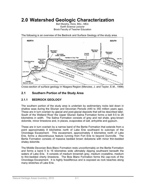
The following is an overview of the Bedrock and Surface Geology of the study area.<br />
Cross-section of surface geology in <strong>Niagara</strong> Region (Menzies, J. and Taylor, E.M., 1998)<br />
2.1 Southern Portion of the Study Area<br />
2.1.1 BEDROCK GEOLOGY<br />
The southern portion of the study area is underlain by sedimentary rocks laid down in<br />
shallow seas during the Silurian and Devonian Periods (440 to 350 million years ago).<br />
These are in turn overlain by glacial and post-glacial deposits that will be described later.<br />
South of the Welland River the Upper Silurian Salina Formation forms a belt 9.5 to 26<br />
kilometres in width. The Salina Formation consists of grey and red shale, grey-brown<br />
dolomite, minor limestone and, in places, evaporates of salt, anhydrite and gypsum.<br />
These are in turn overlain by a narrow band of the Bertie Formation that extends from a<br />
point approximately 8 kilometres north of Lake Erie southward to outcrops of the<br />
Onondaga Escarpment. This escarpment, approximately 4 kilometres north of Lake<br />
Erie, forms a discontinuous feature running from Fort Erie to beyond Dunnville. The<br />
Bertie Formation consists of massive bedded brown dolostone with minor thin-bedded<br />
shaley dolomite.<br />
The Middle Devonian Bois Blanc Formation rests unconformably on the Bertie Formation<br />
and forms a band 5 to 16 kilometres wide ultimately dipping southward beneath the<br />
waters of Lake Erie. It consists of medium brownish grey, medium crystalline, medium<br />
to thin-bedded cherty limestone. The Bois Blanc Formation forms the cap-rock of the<br />
Onondaga Escarpment. It is highly fossiliferous and is exposed as rock beaches along<br />
many stretches of Lake Erie.<br />
Natural Heritage Areas Inventory, 2010 2-1
The exposed portions of the Onondaga Escarpment form local features of note. These<br />
include the exposures just north of Port Colborne on the West Side Road that marks the<br />
boundary of the Wainfleet Bog, and Highway 140 at Chippawa Road. Further east it<br />
provides the route of the scenic Ridge Road north of Ridgeway and the Battle of<br />
Ridgeway exposure on Highway 3. Where the escarpment is exposed the overburden is<br />
thin to absent but thickens southward in the direction the rocks dip.<br />
The Bois Blanc Formation is quarried for crushed stone in operations on both the east<br />
and west sides of Port Colborne. Along with the active operations there are many<br />
abandoned quarries along the escarpment.<br />
The bedrock formations have a general northeast to southwest dip of 3.75 to 9 metres<br />
per kilometer towards a low point known as the Michigan Basin.<br />
2.1.2 SURFACE GEOLOGY<br />
The surface geology consists of glacial and post-glacial deposits. During the retreat of<br />
the last continental ice sheet the study area was inundated by a series of post glacial<br />
lakes beginning 12,900 years ago with the formation of post-glacial Lake Warren. It had<br />
a height of 204 metres a.s.l. (above sea level). It was followed by two lower phases<br />
known as Lakes Grassmere and Lundy at 195 and 189 metres a.s.l.<br />
With the retreat of the ice into the Lake Ontario Basin about 12,500 years ago Lake<br />
Warren and its lower levels drained northward over the <strong>Niagara</strong> Escarpment via a short<br />
lived lake known as Lake Tonawanda. Below and north of the <strong>Niagara</strong> Escarpment the<br />
basin was filled by Lake Iroquois that reached a height of 102 metres a.s.l.<br />
When Lake Warren drained away to become early Lake Erie some remnants of its<br />
waters were trapped between the land rising to the <strong>Niagara</strong> Escarpment in the north and<br />
the face of the Onondaga Escarpment to the south. These entrapments became the<br />
present day Wainfleet Bog, Humberstone Marsh, Willoughby Marsh and numerous other<br />
small wetlands. Prior to the construction of the Welland Canals drainage from these<br />
wetlands was eastward toward the <strong>Niagara</strong> River.<br />
Once the Welland Canals and the Feeder Canal were constructed drainage out of the<br />
Wainfleet Bog was accelerated and rerouted into the canals. Drainage projects to<br />
facilitate agriculture further reduced the extent of the wetlands. Today, only areas east<br />
of the canal now drain to the <strong>Niagara</strong> River. Those west of the canal drain either into it<br />
or down the power canal in <strong>Niagara</strong> Falls via the Welland River. South of the Onondaga<br />
Escarpment a few short streams drain into Lake Erie.<br />
Today, those areas of the former bed of Lake Warren that completely drained away<br />
several thousand years ago are covered with deep clay deposits characteristic of a lake<br />
bottom. They are referred to as the Haldimand Clay plain.<br />
In the north portions of the Haldimand Clay Plain the soils are described as Pedalfer<br />
(formerly Grey Brown Podzols).<br />
Those areas that were the remnant wetlands of Lake Warren are covered by organic<br />
soils derived from deposits of peat and other vegetation characteristic of bogs and<br />
marshes. The post-glacial clay deposits are buried beneath them. The depths of the<br />
Natural Heritage Areas Inventory, 2010 2-2
deposits vary in thickness but in general are deepest just north of the Onondaga<br />
Escarpment, thinning as they extend northward.<br />
The soils that developed on the poorly drained areas in the southeast portion of the<br />
study area are Humic Gleysols.<br />
West of the Wainfleet Bog is an extensive sand plain extending all the way to the Grand<br />
River.<br />
Along stretches of the Lake Erie shore are sand dunes, notably in the areas east and<br />
west of the entrance to the Welland Canal and at Point Abino. The sand dunes are a<br />
result of materials blowing out of the exposed bed of a smaller early phase of Lake Erie.<br />
These dunes have migrated inland ahead of the expanding lake. They have been<br />
stabilized by vegetation and their highest point today is known as Sugarloaf Hill.<br />
Beaches along the Lake Erie shoreline consist of sand in some areas and exposed<br />
bedrock in others. Generally the sand beaches are located in the bays while the<br />
intervening headlands are bedrock. This is the result of wave action by the lake waters.<br />
Numerous large boulders can often be found sitting on the surface of the bedrock<br />
beaches. These are glacial erratics left behind by the retreating glacier. The surface of<br />
the exposed bedrock shows long linear scratches extending from northeast to<br />
southwest. These are the result of gouging by rocks frozen into the ice as the glacier<br />
advanced.<br />
In all areas the present day soils sit unconformably on the bedrock surface. They are<br />
derived from transported materials and do not exhibit the C horizon gradation from<br />
bedrock to regolith characteristic of soils which have developed “in situ”. Instead the C<br />
horizon is derived from glacial till.<br />
2.2 Northern Portion of the Study Area<br />
2.2.1 BEDROCK GEOLOGY<br />
The northern portion of the peninsula is underlain by sedimentary rocks laid down in<br />
shallow seas during the Ordovician and Silurian periods (505 to 409 million years ago).<br />
The lowest formation is known as the Queenston Shale and underlies the portion of the<br />
peninsula from the base of the <strong>Niagara</strong> Escarpment northward to Lake Ontario. It is a<br />
red shale with thin limestone interbeds which forms the uppermost Ordivician strata in<br />
the area. The width of the outcrop, now buried under post glacial deposits, varies from<br />
3.2 to 19.3 kilometres. At the <strong>Niagara</strong> River the strata is approximately 260 metres thick,<br />
thinning to 180 metres thick at Hamilton.<br />
The <strong>Niagara</strong> Escarpment is formed from Silurian strata which overly the Queenston<br />
Shale. The strata are composed of sandstone, shale, limestone and dolostone<br />
formations. At the <strong>Niagara</strong> River these layers can best be observed and consist of, from<br />
bottom to top, the Whirlpool Sandstone, Power Glen Shales and Sandstones, Grimsby<br />
Shales and Sandstones, Thorold Sandstone, Neahga Shale, Reynales Dolostone,<br />
Irondequoit Limestone, Rochester Shale, Decew Dolostone and Lockport Dolostone.<br />
Natural Heritage Areas Inventory, 2010 2-3
It is the hardness of the Lockport and Decew strata overlying softer shales and the<br />
Irondequoit and Reynales strata overlying softer shales and sandstones that resulted in<br />
the erosional feature known as the <strong>Niagara</strong> Escarpment. Because the backslope dips at<br />
an angle less than the face of the escarpment this feature is sometimes identified as the<br />
<strong>Niagara</strong> Questa. The escarpment is a continuous feature running in Ontario from<br />
Queenston to the tip of the Bruce <strong>Peninsula</strong> at Tobermory. In some places there are<br />
deep indentations which represent the sites of former river valleys now mantled by post<br />
glacial deposits, particularly in the St. David’s and Short Hills areas. In most sections<br />
the upper layer of Lockport Dolostone forms a cliff face that gives way to a scree slope<br />
beginning at the top of the Rochester Shale.<br />
South of the brow of the escarpment the Guelph Formation overlies the Lockport<br />
Formation. It appears in the wall of the <strong>Niagara</strong> Gorge about the site of the Rainbow<br />
Bridge and forms the upper rapids above the waterfall. The Guelph Formation is<br />
between 30 and 60 metres thick but does not outcrop anywhere else in the peninsula,<br />
being buried beneath post glacial deposits.<br />
2.2.2 SURFACE GEOLOGY<br />
Except for the <strong>Niagara</strong> Escarpment the bedrock geology of the area is hidden beneath<br />
post glacial deposits. A layer of basal till was deposited directly on the bedrock as the<br />
last phase of continental glaciation waned. The till was then buried beneath lacustrine<br />
deposits of a series of post glacial lakes. The most pronounced and longest lasting of<br />
these was post glacial Lake Iroquois which existed from 12,400 to 11,900 years ago.<br />
This lake, at a height of 102 metres a.s.l., occupied what is now the Lake Ontario basin<br />
to a southern limit that varied between a few hundred metres and several kilometres<br />
from the escarpment. The beach thus formed exists now as a well-defined feature along<br />
which runs Regional Road 81 (formerly Hwy 8). Between the beach and present day<br />
Lake Ontario deposits of silt were laid down over the 500 - 600 year life of the lake. In<br />
some areas sand deposits were laid down.<br />
Rivers entering into Lake Iroquois flowed from south to north and cut through the beach<br />
deposits. At present day Homer (South east St. Catharines), a large baymouth bar was<br />
developed.<br />
When Lake Iroquois drained away with the opening of the St. Lawrence River the water<br />
level dropped, exposing the flat lying silts of the lake bed and is referred to by some as<br />
The Fruit Belt. The positioning of lacustrine silt over the basal till can best be seen in the<br />
bluffs that now form the southern shoreline of Lake Ontario. The existing rivers began to<br />
downcut again to reach the new lower level of the lake. Twelve Mile Creek is an<br />
example of this. Where the rivers enter into Lake Ontario baymouth bars have<br />
developed with lagoons such as Martindale Pond trapped behind them.<br />
Above the escarpment is evidence of an older post glacial lake called Lake Warren<br />
which had a height of 204 metres a.s.l. It existed while the ice still topped the<br />
escarpment and drained southward to the Mississippi River. Its bed is known today as<br />
the Haldimand Clay Plain. Running parallel to the escarpment and just to the south is a<br />
ridge of unconsolidated material known as the Vinemount Moraine. It is best seen as<br />
one travels northward on Regional Road 24.<br />
Natural Heritage Areas Inventory, 2010 2-4
One feature of note is the Fonthill Kame Delta which was developed in Lake Warren by<br />
a river running off the ice. The delta has its highest point at Lookout Point where the<br />
river exited the ice. It grades southwest to a point near Fenwick where the edge can be<br />
determined by the sandy nature of the soil.<br />
The post glacial clays of the Haldimand Clay Plain deepen southward toward the<br />
Wainfleet Bog and Onondaga Escarpment. An appreciation of their depth can be felt as<br />
one descends into the tunnel that passes under the Welland Canal on Townline Road.<br />
Here the sharp contact between the bedrock of the Salina Formation and the overlying<br />
till can be seen.<br />
2.3 A DESCRIPTION OF GEOLOGIC FEATURES WITHIN THE STUDY<br />
AREA<br />
As was described in the geologic overview of the <strong>Niagara</strong> <strong>Peninsula</strong>, there are a number<br />
of features that are locally significant. These will be described in more detail here.<br />
2.3.1 THE ONONDAGA ESCARPMENT<br />
The first of these features, the Onondaga Escarpment, is described both in detail of<br />
present day form and origin because the geologic events described here are important<br />
to understanding the formation of other features as well.<br />
Although not nearly as evident or striking as the <strong>Niagara</strong> Escarpment, the Onondaga<br />
Escarpment is the most obvious geologic feature in the southern portion of the<br />
peninsula. The escarpment is composed of two rock layers; the lower is the Bertie<br />
Formation (of Silurian age) and the upper the Bois Blanc Formation (of Devonian Age).<br />
The rocks are sedimentary in origin and represent periods of time between 410 and 350<br />
million years ago when this area was covered by warm, shallow seas. The Bertie<br />
Formation, consisting of thick beds of brown dolostone and minor beds of shaley<br />
dolomite, rests on top of the Salina Formation which forms a buried band of rock 9.5 to<br />
26 kilometres wide south of the Welland River. (The importance of the Salina Formation<br />
in the development of the present day Onondaga Escarpment will be seen shortly)<br />
The Bois Blanc Formation is a highly fossiliferous limestone with inclusion of chert (also<br />
called flint) and represents the formation of reefs during the Devonian period about 350<br />
million years ago. At that time, because of continental drift, our area was located about<br />
20 degrees south of the equator.<br />
All of the above bedrock layers have a dip of 3.75 to 9 metres per kilometre down to the<br />
southwest.<br />
With the retreat of the seas the area was subjected to a long period of erosion. During<br />
this time the resistant beds of the Bertie and Bois Blanc formation formed a low<br />
escarpment with a north face and a gentle southern back slope. Soils evolved from the<br />
bedrock and a drainage system was created.<br />
The major river through the area flowed eastward in what is now the Lake Erie bed and<br />
eventually found a way northward through a low spot in the Onondaga Escarpment at<br />
Natural Heritage Areas Inventory, 2010 2-5
present day Lowbanks. This river continued northward cutting its valley into the Salina<br />
Formation and out through the <strong>Niagara</strong> Escarpment at present day Short Hills Park.<br />
About two million years ago this area was overridden by the first of four major<br />
continental glaciers. The advancing ice (coming from the northeast to the southwest)<br />
acted like a bulldozer, scraping away the soils, gouging into the bedrock and modifying<br />
the shape of river valleys. This process was repeated three more times and in our area<br />
only evidence of the last glacial period, the Wisconsin, is found. Evidence of the<br />
direction of ice movement is preserved in scratches on the surface of the Bois Blanc<br />
Formation and can be clearly seen in the old Cement Plant Quarry at Quarry Road in<br />
Wainfleet.<br />
The softer beds of the Salina Formation were deeply eroded but the harder Bertie and<br />
Bois Blanc Formations resisted the impact of the ice. About 25 thousand years ago the<br />
ice reached its maximum extent and began to melt away. Large amounts of meltwater<br />
were released to form a series of post-glacial lakes south of the ice front. As the ice<br />
thinned it also lost its ability to erode deeply into the bedrock and began to deposit<br />
material beneath the ice as a mixture of clay to boulders called a basal till. The entire<br />
southern portion of the <strong>Niagara</strong> <strong>Peninsula</strong> is covered by such a till known as the<br />
Wentworth Till, underlying the Haldimand Clay Plain, which is thinnest near the top of<br />
the <strong>Niagara</strong> Escarpment and thickest just north of the Onondaga Escarpment where it<br />
reaches depths of 30 to 45 metres (100 to 150 feet). On top of the Onondaga<br />
Escarpment the till is again thin near the edge and deepens to the south.<br />
As the ice front retreated to a point near the brow of the <strong>Niagara</strong> Escarpment 12,900<br />
years ago, the entire area to the south, including the Onondaga Escarpment, was<br />
covered by the waters of a post-glacial lake named Lake Warren. It was bounded on the<br />
south by the Portage Escarpment in New York and Pennsylvania and reached an<br />
elevation of 200 metres above present sea level. The waters of Lake Warren drained<br />
away westward to the Mississippi River. Layers of sand and clay were deposited in the<br />
lake covering the underlying till in most places. As the ice retreated in stages ridges of<br />
material called recessional moraines were deposited at the ice front but beneath the<br />
waters of the lake. One of these is seen along Bertie Street, Fort Erie in the area of the<br />
Douglas Memorial Hospital today. The largest is the Vinemount Moraine south of the<br />
crest of the <strong>Niagara</strong> Escarpment.<br />
About 12,500 years ago the ice finally retreated into the present day Lake Ontario Basin.<br />
Lake Warren drained away over the <strong>Niagara</strong> Escarpment and the waters eventually<br />
reached the Atlantic Ocean via the Mohawk and Hudson River valleys. A remnant of the<br />
lake was retained in the shallow depression south of the Onondaga Escarpment. This<br />
lake, which reached a height of 140 metres above sea level, was early Lake Erie. Its<br />
waters drained northward into another remnant of Lake Warren called Lake Tonawanda.<br />
From Lake Tonawanda the waters escaped over the <strong>Niagara</strong> Escarpment by way of six<br />
outlets. The largest of these was called the Lewiston Outlet and it is today known as the<br />
<strong>Niagara</strong> River.<br />
Small remnants of the lake were also trapped directly in front of and to the north of the<br />
Onondaga Escarpment. The rise of the land to the north and the escarpment face to the<br />
south forced the drainage from these areas to move from west to east. The areas<br />
became waterlogged and marshy. Deposits of peat accumulated on top of the lake<br />
deposits thus developed the Wainfleet and Humberstone Marshes.<br />
Natural Heritage Areas Inventory, 2010 2-6
Over time the size of Lake Erie expanded to its present extent. The bedrock of the<br />
escarpment now forms the headlands that extend out into the lake as such features as<br />
Morgan’s Point. The shallow dip of the rocks means that the water deepens very slowly<br />
in this lake. In the bays wind and current have caused the accumulation of sand<br />
beaches.<br />
Today the Onondaga Escarpment forms a discontinuous feature a few metres in height<br />
from Fort Erie to beyond Dunnville. In many places it is buried beneath glacial or postglacial<br />
lake deposits. In others it forms local features of note. The most obvious of these<br />
is the outcrop along the West Side Road as it nears Port Colborne from Welland. Other<br />
notable sites are “the ridge” at Ridgeway where the escarpment is followed northeast by<br />
Ridge Road to Bowen Road and as the outcrop now designated the Shagbark Trail.<br />
The presence of the escarpment is also identified by the numerous active and<br />
abandoned quarries along its length. These include those west of Port Colborne along<br />
Highway 3 near Cement Plant and Quarry Roads, east of Port Colborne along Chippawa<br />
Road and East Main Street (Hwy 3), and in Fort Erie at Ridgemount Road. The<br />
escarpment rocks are also seen at Fort Erie in the railroad cut at the intersection of<br />
Bowen and Thompson Roads.<br />
Where the Onondaga Escarpment is prominent the bedrock surface tends to be exposed<br />
or thinly covered by soil near its edge. The soil deepens to the south reaching depths of<br />
up to 15 metres before the shore of Lake Erie is reached. In some areas deep deposits<br />
of sand in the form of dunes cover the bedrock near the shore.<br />
A few short streams flow north to south above the Onondaga Escarpment to enter Lake<br />
Erie. As a result there are no waterfalls of note flowing over the Onondaga Escarpment<br />
as there are with the <strong>Niagara</strong> Escarpment. Most rivers in the peninsula north of the<br />
escarpment flow west to east. One exception is the Grand River which crosses the<br />
rocks of the Onondaga Escarpment from north to south at a low point near Dunnville.<br />
2.3.2 THE WAINFLEET BOG AND HUMBERSTONE MARSH<br />
The bulldozing effect of the Wisconsin Glacier cut deeply into the soft rocks of the Salina<br />
Formation which underlie the southern portion of the <strong>Niagara</strong> <strong>Peninsula</strong>. Directly in<br />
front of the Onondaga Escarpment and east of the Welland Canal this depth to bedrock<br />
reached 15 to 20 metres below the present soil surface. To the west of the Welland<br />
Canal, the depth is even greater, averaging 30 to 45 metres directly north of the<br />
escarpment. In the area of Lowbanks the action of the ice deepened and smoothed the<br />
pre-glacial river valley known today as the Erigan Canyon.<br />
As the ice melted away, still moving from northeast to southwest, it lost its erosive power<br />
and began to deposit materials on the bedrock in what is known as a basal till. Then, as<br />
the area was freed from the ice it flooded beneath the water of Lake Warren and further<br />
deposits of layered sands and clays, known as lacustrine deposits, were laid down over<br />
the till. These deposits show stratification (layering). The waters finally drained away,<br />
first through two lower lake levels and then completely about 12,500 years ago when the<br />
retreat of the ice opened drainage channels over the <strong>Niagara</strong> Escarpment. The result<br />
was essentially a flat plain with deep deposits of clay and a few localized features such<br />
Natural Heritage Areas Inventory, 2010 2-7
as gravel or sand bars. Some of these features show beach lines where they had<br />
emerged as islands in the draining lake.<br />
In the areas immediately north of the Onondaga Escarpment remnants of the lake were<br />
trapped between the escarpment to the south and the gentle rise of the landscape to the<br />
north. The climate was much colder immediately after the retreat of the ice and these<br />
remnants of the lake became extensive bogs with the growth of sphagnum moss. Over<br />
the centuries dead organic materials accumulated in parts of the bogs to form thick<br />
layers of peat. In some places ponds of water persisted, and as the climate warmed<br />
there was a succession of plant types in the area. Water that did escape the area<br />
flowed slowly from west to east in a series of streams that eventually entered the<br />
<strong>Niagara</strong> River.<br />
Had man not interfered this would still be the situation today. However, the construction<br />
of a series of Welland Ship Canals beginning in the mid 19 th century, including the illfated<br />
Feeder Canal, disrupted the natural drainage pattern. The area west of the canals<br />
now drained into them. The canals were deeper than the bogs and so the water table<br />
was lowered. Many of the ponds began to dry up. Clearing of large areas of the bog<br />
for agriculture with subsequent drainage ditches accelerated the process. During the<br />
mid 20 th century these areas became so dry in many summers that smoldering peat fires<br />
would burn for months, being extinguished only by the winter snows. East of the Welland<br />
Canal the areas of bog and marsh are known as the Humberstone Marsh. They<br />
continue to drain eastward via shallow streams to the <strong>Niagara</strong> River.<br />
2.3.3 THE HALDIMAND CLAY PLAIN<br />
In general the entire area of the <strong>Niagara</strong> <strong>Peninsula</strong> south of the <strong>Niagara</strong> Escarpment is<br />
referred to as part of the Haldimand Clay plain. It is composed of glacial till and<br />
overlying lacustrine deposits from post-glacial Lake Warren. The depth of material is<br />
generally less than 15 metres near the lip of the <strong>Niagara</strong> Escarpment and thickens<br />
southward to maximum depths of about 45 metres just in front of the Onondaga<br />
Escarpment. South of the Onondaga the clays again increase southward in depth from<br />
less than a metre to about 3 to 15 metres along the Lake Erie shoreline.<br />
Like the Wainfleet Bog and Humberstone Marsh (which are part of this clay plain) the<br />
remainder of the study area is poorly drained due to the heavy nature of the clays.<br />
Drainage moves from west to east in a few large streams, including the Welland River,<br />
Grand River and Twenty Mile Creek. This is a result of the downward dip of the bedrock<br />
to a structural low occupied by the <strong>Niagara</strong> River.<br />
The plain is very level with only a few local features to break the topography. The most<br />
notable of these is the Fonthill Kame Delta Complex. In the southern part of the plain<br />
local features such as Doan’s Ridge or the Fort Erie Moraine rise only a few metres<br />
above the general landscape.<br />
In the north portions of the Haldimand Clay Plain the soils are described as Pedalfer<br />
(formerly Grey Brown Podzols). They are characterized by a dark surface layer grading<br />
down to a light lower A horizon. The B horizon contains materials leached from the A<br />
horizon and are usually brown to reddish from the accumulation of iron oxides and or<br />
clays. Both horizons are slightly acidic in their pH. The C horizon is partially<br />
decomposed parent material and may be partially cemented by calcium carbonate which<br />
Natural Heritage Areas Inventory, 2010 2-8
has dissolved out of the upper horizons. The material of the C horizon is derived from<br />
unaltered till below.<br />
The soils that developed on the poorly drained areas in the southeast portion of the<br />
study area are Humic Gleysols. The A horizon is dark coloured due to the humus<br />
present. The B horizon is mottled in colour. Leaching may or may not have occurred<br />
from the A horizon due to a high water table.<br />
2.3.4 THE LAKE ERIE SHORELINE<br />
Due to the gentle southerly dip of the rocks of the Onondaga Escarpment Lake Erie<br />
exhibits relatively wide beaches and extensive shallows along its north shore. The lake<br />
came into being about 12,500 years ago with the draining away of the much larger postglacial<br />
Lake Warren. Due to the weight of thousands of years of glacial ice the entire<br />
area had been depressed. When early Lake Erie formed it was much smaller than it is<br />
today.<br />
Slowly the land rose through a process called isostatic rebound. This process continues<br />
even today with the brow of the <strong>Niagara</strong> Escarpment rising at a rate of 20 cm/century.<br />
However, in the center of Lake Erie the rise is now 0 cm/century. As a result the level of<br />
the lake must rise 20 cm/century to continue flowing at the same rate into the <strong>Niagara</strong><br />
River.<br />
The present shoreline of Lake Erie is a result of the thousands of years of isostatic<br />
rebound. Prevailing winds and currents move sand from west to east in the lake. In<br />
some areas this creates long hooked spits such as Turkey Point. In other areas the<br />
sand is removed from points of land into the intervening bays. Here it is also piled into<br />
dunes by the wind.<br />
Early in its history, Lake Erie was actively growing in size. As a result the shoreline kept<br />
moving northward. Since vegetation could not get a permanent hold on the shore the<br />
beaches moved inland just ahead of the water and the sand dunes migrated ahead of<br />
the beaches. Over time the isostatic rebound decreased until the lake almost stabilized<br />
at its present size. This allowed vegetation to gain a foothold on the sand dunes,<br />
stabilizing them and preventing further movement by the wind. For the most part the<br />
tops of the sand dunes appear to be at a constant elevation but some are locally higher.<br />
The highest sand dune in the area is Sugarloaf Hill just west of Port Colborne.<br />
Sand dunes form long sections of the Lake Erie shoreline. The have been extensively<br />
built on for summer cottages and year round homes. Unfortunately these areas<br />
represent the very edge of the active zone of the lake. In rare but severe storms with<br />
high waves the dunes can be attacked and severely damaged. Remedial action such as<br />
the building of breakwalls, groynes or rip rapping can slow the action of erosion.<br />
However, the lake is continuing to refill and eventually will overpower these structures.<br />
One area where large sand dunes are conspicuously absent is at Lowbanks. This is the<br />
opening into the Erigan Canyon, the pre glacial river valley. The valley runs northward<br />
across the Haldimand Clay Plain, beneath the Fonthill Kame and out through the Short<br />
Hills. It is filled with post-glacial debris and shows itself on the surface only as a slight<br />
depression in the landscape, visible only from a distance by observing the treelines that<br />
cross it.<br />
Natural Heritage Areas Inventory, 2010 2-9
On the headlands wave action eats away at the cover of glacial till exposing the bedrock.<br />
The layers are highly fossiliferous and also show numerous chert nodules. There is a<br />
joint pattern in the rocks that divides the surface into large blocks. Wave action attacks<br />
these areas of weakness and wears the bedrock layers into a stepped pattern at the<br />
water’s edge.<br />
There were numerous rounded pieces of rock trapped in the glacial till, ranging in size<br />
from pebbles to boulders. As the finer clay and sand particles were winnowed out by<br />
wave action the rocks, called glacial erratics, were left behind. In some places they, and<br />
the broken pieces from the Onondaga, form pebble beaches. Larger erratics sit<br />
stranded upon the surface of the bedrock, conspicuous by their colour and shape. The<br />
accumulation of pebble beaches is most likely to develop on the eastern side of<br />
headlands.<br />
2.3.5 THE ERIGAN CHANNEL<br />
The Onondaga Escarpment forms a discontinuous feature running east-west across the<br />
southern portion of the Haldimand Clay Plain. In the area of Lowbanks the escarpment<br />
is absent. This site is the beginning of a pre-glacial channel known as the Erigan<br />
Channel. The channel, completely buried by glacial till and the lacustrine deposits of<br />
Lake Warren, is a pre-<strong>Niagara</strong> drainage channel.<br />
The channel was first identified in 1907 by J.W. Spencer. It begins just east of<br />
Lowbanks and runs northward across the peninsula to a point west of Fonthill, exiting<br />
through the <strong>Niagara</strong> Escarpment in the area of the Short Hills. North of the escarpment<br />
there is no present evidence of the channel. Several side channels have been identified,<br />
including one possibly beginning at Dunnville, another running east to west beneath the<br />
Wainfleet Bog and a third called the Falls-Chippawa Valley that begins at the site of the<br />
present <strong>Niagara</strong> Falls and enters the Erigan Channel beneath Fonthill. It has been<br />
suggested that this channel was active several times as the outlet for water from melting<br />
glacial ice prior to the last advance of the continental ice sheet.<br />
Other than the absence of the Onondaga Escarpment at its source and the Short Hills at<br />
its terminus the only physical evidence of the channel on the landscape is a slight dip in<br />
the topography that can best be seen looking southwest from a vantage point near the<br />
intersection of Hwy #20 and Effingham Road on the Fonthill Kame. Where the channel<br />
exists there can be observed a slight dip in the treelines. This indicates a shallow<br />
depression in the landscape.<br />
At Lowbanks the channel is about three kilometers wide and it maintains this width<br />
throughout most of its length. At St. Johns West it narrows to about two kilometers in<br />
width.<br />
Since the channel predates the present great lakes there must have been an extension<br />
north of the <strong>Niagara</strong> Escarpment into a river that flowed in what is the present day Lake<br />
Ontario Basin. However no evidence of this northerly extension across the present day<br />
Lake Iroquois bench or plain is indicated on maps produced by current researchers.<br />
Natural Heritage Areas Inventory, 2010 2-10
2.3.6 POST GLACIAL LAKE WAINFLEET<br />
Approximately 13,000 years ago the southern portion of the peninsula was covered by<br />
the waters of Lake Warren. Since the Lake Ontario basin was filled by glacial ice which<br />
extended up over the <strong>Niagara</strong> Escarpment the waters of Lake Warren drained away<br />
west and southward to the Mississippi River. When the ice cleared, the escarpment<br />
Lake Warren drained northward via the <strong>Niagara</strong> River and Lake Tonawanda (as<br />
described in the section titled “The <strong>Niagara</strong> River”). Two phases in the reduction of Lake<br />
Warren are identified as Lakes Grassmere and Lundy. A beach line for Lake Lundy is<br />
evident on the <strong>Niagara</strong> Falls Moraine.<br />
For several thousand years thereafter the amount of water discharged through the<br />
<strong>Niagara</strong> River was controlled largely by the melting of glacial ice in the Lake Huron and<br />
Superior Basins. Several phases of this melting produced large volumes of water that<br />
can be identified by the width of sections of the <strong>Niagara</strong> Gorge. High water volumes<br />
between 11,000 and 10,500 years ago inundated southern portions of the peninsula in a<br />
phase referred to by some authors as Lake Wainfleet. This lake would have expanded<br />
and waned in size dependent upon the outflow from the upper lake basins. This lake<br />
persisted until about 10,200 years ago.<br />
Evidence of these late phase floodings, including Lake Wainfleet have been identified as<br />
strand lines or beaches evident on other features within the area. For example, there is<br />
a strand line evident on the long sand bar between Ridgeway and Sherkston. At<br />
Doan’s Ridge there is a faint beach line on a gravel bar. Another faint beach line is seen<br />
near Lodba’s Corners in Wainfleet.<br />
When water volumes were high there were probably several channels from Lake Erie<br />
into Lake Wainfleet across the Onondaga Escarpment. The old Erigan Channel would<br />
have been one. Ultimately the waters would have escaped northward via the Welland<br />
and <strong>Niagara</strong> Rivers.<br />
During low levels the area north of the Onondaga Escarpment would have contained a<br />
series of connected ponds. As isostatic rebound raised the land the ponds would have<br />
drained eastward back into the <strong>Niagara</strong>. Today the remnants of some of these are<br />
represented by the poorly drained areas of the Wainfleet Bog, Humberstone Marsh and<br />
Willoughby Marsh as well as many smaller sites.<br />
2.3.7 THE DUNNVILLE SAND PLAIN<br />
A late stage of Lake Warren called Lake Lundy saw water levels drop to expose most of<br />
the peninsula south of the <strong>Niagara</strong> Escarpment. Drainage from this lake was northward<br />
through the present day St. Clair River into an early stage of Lake Huron called Early<br />
Lake Algonquin. At one point in time the area immediately to the east of Dunnville was<br />
flooded. The Grand River built a sandy delta into this embayment at a height of about<br />
180 metres a.s.l.<br />
Eventually the ice cleared the <strong>Niagara</strong> Escarpment allowing Lake Iroquois to form and<br />
causing the drainage to now flow from the Lake Erie basin northward through the<br />
Lewiston Spillway. The drop in water level was enough to change the outlet of the<br />
Grand River to its present position. The sandy delta was abandoned and exists today as<br />
a sand plain extending from the Grand River as far eastward as the Wainfleet Bog. It<br />
Natural Heritage Areas Inventory, 2010 2-11
terminates to the south at Lake Erie and along a northern perimeter that begins at the<br />
Grand River about twelve kilometers from the lake.<br />
In all the sand plain covers an area of over 300 square kilometers.<br />
The two main branches of Big Forks Creek arise from this sand area.<br />
2.3.8 DRAINAGE ON THE HALDIMAND CLAY PLAIN<br />
The three largest streams that drain the Haldimand Clay Plain are the Grand River,<br />
Welland River and Twenty Mile Creek. They meander west to east across the plain.<br />
The Grand River enters Lake Erie at Port Maitland having been controlled by the<br />
location of the Onondaga Escarpment and ultimately finding a low notch through which it<br />
enters the lake.<br />
The Welland River (also known as the Chippawa Creek) enters the <strong>Niagara</strong> River at<br />
Chippawa. In fact it once did this but now the last 6 kilometres has been reversed to<br />
provide the intake for the Chippawa-Queenston power canal. In addition the river has<br />
been diverted under the Welland Ship Canal via large siphons at Welland and Port<br />
Robinson.<br />
The Twenty Mile Creek enters Lake Ontario via a notch in the <strong>Niagara</strong> Escarpment at<br />
Ball’s Falls.<br />
The topography of the clay plain is very flat and the rivers meander sluggishly across it.<br />
The Welland River only drops seventy-three metres in one hundred and sixteen<br />
kilometers from its source to its mouth. Of this drop sixty metres occurs in the first<br />
twenty-four kilometres of its length. As a result the gradient for the remainder is less<br />
than fifteen centimeters per kilometre. The river has few large tributaries, notably Lyons<br />
Creek and Big Forks Creek. It carries a high sediment load derived from the lacustrine<br />
deposits of the plain. The slip-off slopes on the inside of meanders are low and broad<br />
and during spring runoff considerable inundations of the flood plain can occur. Natural<br />
levees are very faint. Several cut off meanders can be observed from aerial<br />
photographs and on the ground are observed as shallow sloughs.<br />
The major control for the west east flow of this river is the slight drop in elevation from<br />
west to east caused by the bedrock topography which dips down to the low of the<br />
<strong>Niagara</strong> River channel. Other local controls are subtle features such as beaches<br />
formed by the various levels of Lake Warren and poorly defined recessional moraines.<br />
The Twenty Mile Creek is similar to the Welland River in that it flows from west to east<br />
across a very low gradient. However a major control to the north is the long low<br />
Vinemount Moraine that occurs just south of the crest of the <strong>Niagara</strong> Escarpment. This<br />
moraine was deposited by the retreating glaciers in the waters of Lake Warren. The<br />
river parallels it and finally finds a way to break through to the north via the channel at<br />
Ball’s Falls. This creek drains an area of only 300 square kilometers. The remainder of<br />
the clay plain is drained primarily by the Welland and Grand Rivers.<br />
The Onondaga Escarpment controls the southern limit of drainage into the Welland<br />
River. Just north of the escarpment the drainage is poor, creating a series of wet areas<br />
Natural Heritage Areas Inventory, 2010 2-12
including the Wainfleet Bog, Humberstone Marsh and Willoughby Marsh. A few short<br />
streams such as Baker’s Creek and Frenchman’s Creek drain eastward to the <strong>Niagara</strong><br />
River. Above the escarpment the dip down to Lake Erie creates a series of short streams<br />
flowing to the south.<br />
2.3.9 THE NIAGARA RIVER<br />
Approximately 12,500 years ago the retreat of glacial ice reached the present day Lake<br />
Ontario Basin. With the freeing of the <strong>Niagara</strong> Escarpment from the ice post-glacial<br />
Lake Warren drained away to the north, leaving a small remnant behind called Early<br />
Lake Erie. The flow of glacial meltwater from this lake northward created a channel that<br />
began between present day Fort Erie and Buffalo. Before reaching the escarpment the<br />
waters filled a long east-west depression to form a narrow lake in the location of present<br />
day Tonawanda Creek. This lake, approximately 100 kilometres long, was known as<br />
Lake Tonawanda. It had six outlets over the escarpment into a new post-glacial lake<br />
known as Lake Iroquois. From east to west they are known as the Holley, Medina,<br />
Gasport, Lockport, Devil’s Hole and Lewiston Outlets.<br />
Over time isostatic rebound caused the land to slowly rise and gradually each outlet<br />
dried up as Lake Tonawanda shrank toward the low of the Lewiston Outlet. Each outlet<br />
produced a gorge extending back from the lip of the escarpment and since the Lewiston<br />
existed for the longest period of time and had the major flow of water over it, that gorge<br />
became the largest. Its original waterfall was at Queenston.<br />
The retreat of the waterfall was at a rate of about a metre a year. It was also controlled<br />
by a series of joints in the caprock of the <strong>Niagara</strong> Escarpment known as the Lockport<br />
Dolostone. Today, that gorge is approximately eleven kilometers long and its waterfalls<br />
are now known as the Horseshoe and American Falls. The outlet is now more<br />
commonly known by a different name – the <strong>Niagara</strong> River.<br />
With the melting away of the continental glaciers the flow of water in the Lewiston Outlet<br />
fluctuated over time. During periods of high water the gorge width was wide, and at<br />
other times it was narrow. Eventually the flow of water decreased to reflect only the<br />
volume supplied by the annual water cycle. The channel above the waterfall reflected<br />
this decrease by becoming more narrow, abandoning its original banks. These<br />
abandoned banks can be observed in many places such as in Fort Erie where a<br />
conspicuous drop occurs on all east west streets approaching the river. It is also very<br />
noticeable parallel to the present day <strong>Niagara</strong> Gorge on both sides of the river.<br />
It might be argued that the <strong>Niagara</strong> River should still be referred to as the Lewiston<br />
Spillway because it lacks many of the features associated with a river. There is little<br />
change in volume between its source and its mouth. It has few tributaries, the Welland<br />
River being the only one of significance. Its change in yearly volume is only by a factor<br />
of two, whereas most rivers show a marked increase and decrease in volume related to<br />
the seasons. It does not meander across the Haldimand Clay Plain in a fashion seen by<br />
most rivers. It is also very short, joining two lakes over a distance of only about 45<br />
kilometres.<br />
Natural Heritage Areas Inventory, 2010 2-13
2.3.10 THE FORT ERIE MORAINE<br />
The process of freeing the peninsula from the grip of the continental glacier was not<br />
measured in a constant number of metres per year. Variations in the climate resulted in<br />
some periods when the ice retreated, some periods when there were minor advances<br />
and others where the ice front remained static for some time. During periods when the<br />
front remained static summer meltwater would deposit materials released from the ice as<br />
a long ridge along its margin. These features are called recessional moraines. Three<br />
such features are recognized within the peninsula. They are the Vinemount, <strong>Niagara</strong><br />
Falls and Fort Erie moraines.<br />
The Fort Erie moraine is located on the back slope of the Onondaga Escarpment. Some<br />
authors suggest that the moraine extended across what is now the course of the <strong>Niagara</strong><br />
River about 12,500 years ago. When the waters of Lake Warren drained over the<br />
escarpment to expose the peninsula as dry land and create early Lake Erie the moraine<br />
would have acted as a dam. This would have caused early Lake Erie to rise several<br />
metres in order to overcome this obstacle to its outflow. Only when the moraine had<br />
been eroded did the lake drop to its current level.<br />
Being the furthest south, the Fort Erie moraine is the oldest but also one of the most<br />
poorly defined. It is best seen as a low ridge running westward from the <strong>Niagara</strong> River<br />
along Bertie Street in Fort Erie. Since the moraine was deposited in the waters of Lake<br />
Warren its surface features are smooth and do not exhibit the hummocky features of<br />
moraines deposited above water. The north face of the moraine is more pronounced<br />
than the south face. This can be best seen on Bertie Street in the area of the Douglas<br />
Memorial Hospital. The moraine creates a rise in the landscape a few metres high and<br />
up to a kilometre in width. Moraine materials are poorly sorted and contain all particle<br />
sizes from clay to glacial erratics. The moraine terminates at a western point about eight<br />
kilometers from the <strong>Niagara</strong> River.<br />
The Fort Erie moraine has been extensively built upon and the initial section of the<br />
Queen Elizabeth Way crosses it.<br />
Attempts have been made to correlate this moraine with an east west moraine feature<br />
about fifteen kilometres long south of Hamilton. In their publication “The Physiography<br />
of Southern Ontario, Third Edition, Chapman and Putman identify both these features as<br />
parts of the Fort Erie moraine. However there is a complete absence of the moraine<br />
between Ridgeway and Binbrook.<br />
2.3.11 THE VINEMOUNT, FORT ERIE AND NIAGARA FALLS MORAINES<br />
Three east west trending moraines are found on the Haldimand Clay Plain above the<br />
<strong>Niagara</strong> Escarpment. These are recessional moraines resulting from times when the ice<br />
front stabilized for a period. The rate of advance equaled the rate of melt and as a result<br />
materials being transported by the ice were released and accumulated along the static<br />
ice front. Of the other two, the most prominent is the Vinemount Moraine. It is located<br />
just south of the brow of the escarpment and is recognized as a low ridge of clayey till.<br />
This moraine was deposited into the waters of a late stage of Lake Warren. As a result it<br />
is a low, linear feature recognizable at a distance, but without sharp contrast to the<br />
surrounding landscape. Its northern limit extends almost to the brow of the escarpment.<br />
Directly to the south of the moraine are lacustrine deposits overlying the glacial till.<br />
Natural Heritage Areas Inventory, 2010 2-14
The Vinemount Moraine can be traced westward beyond Waterdown and in this area it<br />
is a distinct ridge of silty, stony till. It extends eastward as far as the <strong>Niagara</strong> River and<br />
then into New York State. In some places it is interrupted by local features such as the<br />
Short Hills and St. David’s Buried Gorge.<br />
The <strong>Niagara</strong> Falls Moraine, further south, is a much more subdued feature, a mere swell<br />
in the clay plain east of the Welland Canal. Only in the area of Lundy’s Lane where it is<br />
topped by a gravel bar is it truly distinct.<br />
The most southerly of the three, the Fort Erie Moraine has already been described for<br />
that section near Fort Erie itself. South of Hamilton a low ridge of clayey material<br />
extends for several kilometers south of the Twenty Mile Creek. Binbrook and Mount<br />
Hope are both set on its crest. Eight kilometers east of Binbrook it becomes indistinct<br />
but still has enough relief to serve as the drainage divide between the Welland River and<br />
the Twenty Mile Creek. Although this has been identified as an extension of the Fort<br />
Erie Moraine by authors such as Chapman and Putnam, there is a large gap of over<br />
forty kilometers between the east and west sections.<br />
In the area around Smithville, along Hwy 20 the landscape shows low hills, ridges and<br />
indented stream valley, uncharacteristic of the flat landscape further east. This is the<br />
area where the <strong>Niagara</strong> Falls Moraine to the north and the Fort Erie Moraine to the south<br />
created a narrow zone through which flows the Twenty Mile Creek.<br />
The Vinemount Moraine also has an influence on the flow of area streams, particularly<br />
the Twenty Mile Creek. This feature and the eastward slope of the landscape causes<br />
the Twenty Mile Creek to flow sluggishly across the clay plain south of the moraine from<br />
west to east. In the area of Vineland the stream finally finds a point where it cuts<br />
northward through the moraine, crossing the escarpment at Ball’s Falls. The stream<br />
then enters Lake Ontario via the lagoon at Jordan Harbour.<br />
2.3.12 THE FONTHILL KAME-DELTA<br />
The most noticeable feature found on the Haldimand Clay Plain is the Fonthill Kame-<br />
Delta. It is a northeast to southwest trending structure with its highest elevation in the<br />
north and sloping southward to a terminus near Fenwick. The highest point is near the<br />
intersection of Effingham and Tice Roads at an elevation of 260 metres a.s.l.<br />
The kame-delta is an ice front feature that resulted from meltwater pouring off the ice<br />
and depositing material into the waters of Lake Warren. As the lake level rose over<br />
several years the kame-delta also rose keeping its upper surface at about the level of<br />
the lake. The deposits are primarily of sand and gravel and there are evidences of<br />
distributaries near its upper level. Generally speaking the materials are sorted with the<br />
largest particles, boulders to gravel, at the north end grading down to sand farther south.<br />
Intermingled beds of sand and gravel would indicate yearly changes in outflow from the<br />
melting ice. Localized deposits with unique characteristics are also seen. For example,<br />
at the northern tip of the feature, just west of North Pelham Street was a deposit of fine<br />
sand that was mined out in the early 1900’s for molding sand.<br />
The northern terminus of the kame-delta was supported by the ice and when the glacier<br />
finally receded the north side collapsed creating the steep slope seen at Lookout Point.<br />
Natural Heritage Areas Inventory, 2010 2-15
The Fonthill Kame-Delta is the catchment area for rainwater that ultimately enters into<br />
tributaries of both the Twelve Mile Creek, the Welland River, Fifteen, Sixteen and<br />
Eighteen Mile Creeks, and Singers Drain. Rainwater exits from the north side of the<br />
kame-delta via a series of springs that create streams to cut deeply into the landscape<br />
ultimately flowing through the Short Hills area to the Twelve Mile Creek. On the south<br />
side of the kame-delta the springs create marshy areas in the clays of the Haldimand<br />
Clay Plain and ultimately reach the Welland River. It is these springs that gave Fonthill<br />
its original name (from “Fountain Hill”).<br />
Beach lines of two lower levels of Lake Warren, Lakes Grassmere (195 m. a.s.l.) and<br />
Lundy (189 m. a.s.l.) are found on the sides of the kame-delta. The kame-delta sits at<br />
the upper end of the portion of the Erigan Channel that is now occupied by the Short<br />
Hills.<br />
In its higher elevations the kame-delta has been extensively mined in the past for<br />
deposits of sand and gravel. Numerous small pits are still in evidence. Larger<br />
operations have been rehabilitated such as the one that now encompasses <strong>Peninsula</strong><br />
Lakes Golf Course. One pit is still in production. These operations plus the removal of<br />
the original forest cover has had an impact on the water regimen of the area. Spring<br />
runoff is high but many streams still do flow in the drier summer months.<br />
The town of Fonthill occupies the northeast section of the kame-delta. Extensive tender<br />
fruit farming once occurred over much of the remaining surface, but is now replaced by<br />
urban development. The limit of the sand deposits of the kame-delta to the south can be<br />
determined largely by the limit of tender fruit cultivation.<br />
2.3.13 THE SHORT HILLS<br />
The Short Hills occupy the notch (called a re-entrant) in the <strong>Niagara</strong> Escarpment created<br />
by the Erigan Channel. They are bounded by the Fonthill Kame-Delta to the south.<br />
More than half of the area is now within the boundary of Short Hills Provincial Park.<br />
Contrary to their name, the Short Hills do not rise up above the surrounding Haldimand<br />
Clay Plain but rather sit down within the escarpment re-entrant.<br />
During the last period of glacial advance the re-entrant was scoured and modified by the<br />
ice. As the ice retreated glacial till was deposited in the re-entrant and then covered by<br />
a layer of lacustrine material released from the ice and deposited in the waters of a late<br />
stage of Lake Warren. When the lake drained away a dendritic drainage pattern was<br />
established on these deposits and cut deeply into the unconsolidated materials. The<br />
ultimate direction of flow was northward into the channel of the Twelve Mile Creek. This<br />
process continues today. The Short Hills are the remnants of the original surface now<br />
deeply dissected by ravines and valleys.<br />
Where streams entered into the feature from the east or west, they ultimately had to<br />
cross over the <strong>Niagara</strong> Escarpment. Waterfalls were created which then began to erode<br />
back into the escarpment creating gorges. The largest of these waterfalls is Swayze<br />
Falls which drains a western branch of the stream system into the valley. A similar, but<br />
somewhat less impressive, waterfall known as Terrace Creek Falls drains a major<br />
stream from the east. Throughout the short hills there are numerous other small<br />
Natural Heritage Areas Inventory, 2010 2-16
cataracts which form where bedrock is exposed along the rim of the surrounding<br />
escarpment.<br />
Today the area is largely forested except on the remnants of the upper surface where<br />
farming has continued until the present. Some of these farm fields have been replanted<br />
in reforestation projects beginning in the late 1970’s and 80’s. There is ample evidence<br />
of farming in the short hills even in areas that have now returned to forest. This includes<br />
abandoned farm lanes, old farm machinery and old orchards.<br />
The original settlers to the area in the early 19 th century capitalized on the year round<br />
flow of streams and the steep stream gradients by setting up mills utilizing waterpower.<br />
On the east side of the short hills the historic community of St. Johns West once had<br />
twelve mills utilizing the stream. Remnants of mill-races and dams to create millponds<br />
can still be seen. Similar remnants can be seen on the west side of the short hills in the<br />
area of Effingham.<br />
Many of the streams in the Short Hills are ephemeral today, that is to say they flow only<br />
after a rainfall or at the time of the spring thaw. During these times the streams are still<br />
actively eroding the post-glacial deposits. Major streams run year round, in some cases<br />
augmented by springs such as one just north of the St. Johns Outdoor Studies Centre.<br />
The most active scene of erosion today is an area known as the land-slip which is<br />
located about a kilometre south of the Pelham Road parking lot of the Provincial Park.<br />
This huge slump probably began to develop in the 1940’s or 50’s when the meander of<br />
the stream began to undercut the slope. It continues today and is more than a hundred<br />
metres wide.<br />
2.3.14 THE LAKE IROQUOIS PLAIN AND BENCH<br />
Lake Iroquois was perhaps the most famous of the post-glacial lakes to cover parts of<br />
the peninsula. It covered all of the present day Lake Ontario basin and rose to a height<br />
of 102 metres a.s.l before finding an outlet by way of the Mohawk Valley at present day<br />
Rome, New York. Lake Iroquois formed about 12,500 years ago when the glacial<br />
retreat reached a line north of Toronto. The lake received water from above the<br />
escarpment via six outlets, the most westerly of which was called the Lewiston Outlet<br />
and is today known as the <strong>Niagara</strong> River. Ice still plugged the St. Lawrence and for this<br />
reason the lake rose to a high level.<br />
Lake Iroquois existed for a period of 500 to 600 years. During that time thick deposits of<br />
lacustrine silt were laid down over the glacial till forming the lake bottom. The settling<br />
out of silty material on the lake bottom created a flat landscape with little relief. Here and<br />
there are large boulders called glacial erratics that were released from the melting ice, or<br />
from ice chunks that broke off and floated out into the lake. These exposed lake<br />
deposits, up to five metres thick, are known today as the <strong>Niagara</strong> Fruit Belt.<br />
The till in turn sits unconformably on the Queenston Shale.<br />
The lake developed a prominent beach that now runs across the peninsula from the<br />
<strong>Niagara</strong> River, right around Lake Ontario to Trenton. In the <strong>Peninsula</strong> the beach lies 3 to<br />
12 kilometres from the present lake. Between St. Catharines and Hamilton much of<br />
Regional Road 81 follows the beach.<br />
Natural Heritage Areas Inventory, 2010 2-17
Between the beach and the <strong>Niagara</strong> Escarpment the landform is known as the Lake<br />
Iroquois Bench. It is predominantly glacial till. Streams entering Lake Iroquois from the<br />
north cut valleys into the bench and created baymouth bars across the beach openings.<br />
The largest of these bars is the Homer Bar now covered by residences and cemeteries<br />
in St. Catharines.<br />
When Lake Iroquois drained with the opening of the St. Lawrence 11,800 years ago the<br />
lake bottom was laid bare. The initial phase of Lake Ontario was only slightly above sea<br />
level (8 metres a.s.l.). The streams entering this lake reactivated their downward<br />
erosion. As a result the valleys crossing the bench were extensively deepened. When<br />
these streams reached the bed of Lake Iroquois they began downcutting to reach the<br />
new base level of Early Lake Ontario. At present Regional Road 81 (formerly Hwy 8)<br />
descends into some of the larger stream valleys that have cut through the Lake Iroquois<br />
Bench via a steep gradient to accommodate the depth of the valley. This is particularly<br />
true of the valley of the Twenty Mile Creek.<br />
2.3.15 THE LAKE ONTARIO BLUFFS<br />
Unlike Lake Erie the shoreline of Lake Ontario has no well-developed, wide beaches.<br />
Instead, the edge of the lake has a gravel beach only a few metres wide which ends at a<br />
bluff consisting of unconsolidated till overlain by lacustrine deposits of predominantly fine<br />
silt. The bluff varies in height up to 10 metres in some places.<br />
The cause of this feature is essentially isostatic rebound in the Lake Ontario Basin and<br />
St. Lawrence River. When Lake Iroquois drained away with the opening of the St.<br />
Lawrence about 11,800 years ago the continent had been depressed by the mass of the<br />
ice which once reached a thickness in our area of up to two kilometers. As a result the<br />
earliest stage of Lake Ontario (called the Admiralty Phase) was only 8 metres above sea<br />
level and filled only about three quarters of its present basin. The western end of this<br />
early lake was approximately even with present day St.Catharines. The entire St.<br />
Lawrence Valley was inundated by the ocean to form the Champlain Sea. The land then<br />
began to “bounce back” and the rise of the bed of the St. Lawrence in the area of the<br />
Thousand Islands caused water to pond in the Lake Ontario Basin. This process<br />
continues today with isostatic rebound in the St. Lawrence rising at 40 cm/century while<br />
the Lake Ontario Basin is rising at 20 cm/century.<br />
The deposits forming the bed of Lake Iroquois once extended further to the north. But<br />
as the lake basin refilled the water wave action began to attack the deposits. The<br />
unconsolidated materials were easily eroded and continue to do so today.<br />
Over time the area of the lake expanded to eventually encompass its present size by<br />
9,000 years ago.<br />
The rate at which these bluffs are being destroyed varies from year to year. When lake<br />
levels are low the small beach that is formed is enough to protect the bluffs. During<br />
periods of high water the erosion is much greater. In 1972, during a period of high<br />
water, some areas of the bluffs were eroded back by tens of metres.<br />
Evidence of erosion can be seen in the area of Charles Daley Park where there are<br />
remnants of concrete abutments out in the lake. These are the remains of a bridge<br />
which crossed the Fifteen Mile Creek at a time when there was an east west road<br />
Natural Heritage Areas Inventory, 2010 2-18
unning along the top of the bluff. The entire structure and road are now gone as a<br />
result of the retreat of the bluffs.<br />
The lake Ontario Basin continues to fill at a rate of 20 centimetres/century. Add to this<br />
the projection that the Great Lakes Basin could receive 25% more precipitation as a<br />
result of climate change. The result is that the Lake Ontario bluffs will continue to be<br />
destroyed by the lake.<br />
2.3.16 THE LAKE ONTARIO BAYMOUTH BARS AND LAGOONS<br />
With the exception of the <strong>Niagara</strong> River all other streams entering Lake Ontario have at<br />
their mouth a lagoon which is separated from the lake by a baymouth bar. This is a low<br />
structure consisting primarily of gravel with some sand that extends from the west side of<br />
the lagoon toward the east. There is an opening on the east side of the bar which allows<br />
water to drain into the lake.<br />
These features are a result of two actions. The first of these is the rise in the level of<br />
Lake Ontario. When the lake first formed at its level of 8 metres a.s.l. the streams<br />
flowing into the former Lake Iroquois were forced to begin downcutting through the<br />
lacustrine and till deposits to reach the new lake. Over time the rise in the lake level<br />
drowned these river mouths.<br />
The second action is called the longshore drift. The movement of water along the south<br />
side of Lake Ontario in the area west of the <strong>Niagara</strong> River is from west to east. This<br />
water can move fine materials. At the same time wave action is primarily perpendicular<br />
to the shoreline. As a result a wave will drive material up the narrow beach and the<br />
returning water, influenced by the longshore drift will drag the materials slightly to the<br />
east.<br />
When a river mouth is encountered the longshore drift will begin to deposit material at<br />
the extreme western edge of the stream. Over time the action of wave and longshore<br />
drift will extend this material eastward to form a baymouth bar. Water will pond behind<br />
this obstruction to form a lagoon. If the stream has little flow the water will escape from<br />
the lagoon by infiltrating through the bar. However if there is enough flow the stream will<br />
escape from the eastern extreme of the bar by cutting a channel.<br />
This diversion of water to the eastern side of the lagoon increases the rate of erosion of<br />
the bluff on this side. The lagoon begins to extend itself eastward and the baymouth bar<br />
keeps pace.<br />
The reason there is no baymouth bar at the mouth of the <strong>Niagara</strong> River is because of the<br />
high rate of flow of this body. There is too much force in the current of the river as it<br />
enters the lake for a bar to form. Instead the materials are swept away.<br />
Periodically the baymouth bars have been destroyed by high lake levels and wave<br />
action. In 1972 the baymouth bar across the Fifteen Mile Creek was almost entirely<br />
destroyed and the western section that remained was overtopped by the waves. Within<br />
two years time the lake had completely rebuilt the baymouth bar.<br />
Natural Heritage Areas Inventory, 2010 2-19
2.3.17 THE ST. DAVID’S BURIED GORGE<br />
The most recent period of glaciation, known as the Wisconsin Period, actually overrode<br />
the <strong>Niagara</strong> region more than once. A major advance that began over 100,000 years<br />
ago went through a period of retreat that saw the region ice-free again about 70,000<br />
year ago. At that time a river formed where the upper <strong>Niagara</strong> River flows today.<br />
However its outlet over the escarpment was at a point above the village of St. David’s.<br />
The retreat of the waterfall created a gorge from that point southward to about where the<br />
Lower Rapids Bridge is today. Then, about 50,000 years ago the ice returned.<br />
When the final melting of the ice 12,000 years ago reached this area the pre-existing<br />
gorge had been completely filled with glacial debris. The river, now reformed, as the<br />
Lewiston Spillway flowed over the top of this debris to a point where the <strong>Niagara</strong><br />
Whirlpool is today. Then, for some reason, it turned ninety degrees eastward and flowed<br />
ultimately over the escarpment at Queenston.<br />
For the next several thousand years the waterfall retreated upstream, reaching the site<br />
of the previous gorge about 6 – 7,000 years ago. When the erosion of the escarpment<br />
caprock broke through into the pre-existing gorge the force of the river began to flush out<br />
the sands and gravels it contained. The section from the whirlpool to the upper Rapids<br />
Bridge may have been completely flushed out of debris in a matter of a few weeks.<br />
For some reason the river did not flush out the debris north of the whirlpool. Instead,<br />
when the waters entered this area they swirled around counter-clockwise and then<br />
continued downstream to exit at Queenston. The whirlpool had been formed.<br />
What remained of the unopened old gorge is called the St. David’s Buried Gorge. Early<br />
settlers recognized the area as a valuable deposit of sand and gravel. A sand pit was<br />
opened and a road (St. Paul Ave.) built down through the notch in the escarpment.<br />
Numerous glacial erratics were uncovered during the excavation of the sands. One in<br />
particular, the size of a bus, had clear evidence of glacial erosion on its upper surface.<br />
The existence of the buried gorge caused problems with the building of both H.E.P.C.<br />
canals in that the absence of bedrock in the area forced the builders to use concrete rip<br />
rapping to prevent the canal walls from collapsing.<br />
When the sand pit was finally exhausted of its material it was converted into a golf<br />
course and residential housing.<br />
2.3.18 THE NIAGARA GORGE AND GLEN<br />
The present <strong>Niagara</strong> River formed about 12,500 years ago when the retreating glacier<br />
finally cleared the <strong>Niagara</strong> Escarpment. A waterfall that was originally about 10 metres<br />
high formed at what is now Queenston. Over time the erosive power of the water cut<br />
into the bedrock creating a gorge that retreated upstream at a rate of about a metre a<br />
year.<br />
Since the amount of water coming through the system varied at different times<br />
depending upon the melting of the ice and the various other channels that allowed water<br />
to flow from other post-glacial lakes this gorge also varied in width.<br />
Natural Heritage Areas Inventory, 2010 2-20
An observer today would note that the present <strong>Niagara</strong> Gorge that is about eleven<br />
kilometers long is actually composed of a number of linear sections with sharp angular<br />
turns that lead into the next one. Near Queenston the gorge is referred to as the First<br />
Gorge and it becomes the Old Narrow Gorge as one moves upstream. The next section<br />
is called the Devil’s Hole Gorge and it is located just south of the Sir Adam Beck Hydro<br />
Plants. The notch in the American side of the gorge called the Devil’s Hole is one of the<br />
other spillways that drained water from post-glacial Lake Tonawanda. Here there is a<br />
change in direction to a southeasterly lineation.<br />
Above this point the gorge becomes quite wide until it reaches the <strong>Niagara</strong> Glen. The<br />
Glen is a unique feature. The waterfall had reached this point about 8,000 years ago. It<br />
was a wide torrent as indicated by the width of the gorge. Erosion of the waterfall began<br />
to create a U-shaped structure with the major flow of water now directed toward the<br />
American side of the river. Over time less water flowed over the western side and as a<br />
result blocks of Lockport Dolostone eroded from the gorge wall fell into the river here but<br />
were not swept away by the current. These blocks created a talus slope which reached<br />
as high as the contact between the dolostone and the underlying softer Rochester<br />
Shale.<br />
Soon the flow was unable to cut through both the Lockport Dolostone and the<br />
Irondequoit Limestone layer beneath the shale with the same intensity. As a result the<br />
waterfall began to assume a stepped appearance falling first from the upper level of the<br />
river to the top of the Irondequoit and then over this sill to the gorge below. Eventually<br />
the accelerated retreat of the main waterfall caused the crest on the Canadian side to<br />
intersect the river channel and the whole of the west side of the waterfall went dry. The<br />
talus pile is what is known as the <strong>Niagara</strong> Glen today. A plunge pool at the upper end of<br />
the Glen is known as Cripp’s Eddy.<br />
Erosion continued upstream until the retreat of the waterfall intersected the older buried<br />
gorge at what is now the whirlpool (previously described) and for a period of perhaps a<br />
few weeks the waterfall disappeared, replaced by a raging torrent filled with sands and<br />
gravel. The waterfall reformed as soon as the debris had been flushed out of the old<br />
channel. The gorge had also taken another sharp turn and was retreating almost south<br />
again.<br />
The retreat continued until about 900 years ago when the waterfall was at the location of<br />
the present day American Falls. At this point the river flowed almost due west and went<br />
around Goat Island in two channels. The majority of the water went south of the island<br />
and the increased rate of erosion caused the water to separate into two cataracts at this<br />
point. The larger one, now known as the Horseshoe or Canadian Falls, continued its<br />
retreat upstream. The other was to suffer the same fate as had occurred thousands of<br />
years before at the Glen. Not enough water flowed over the crest to wash out the<br />
broken rock. It piled up to cover the shale and erosion ceased. It has been estimated<br />
that the Canadian Falls will reach the upper end of Goat Island in about 1,500 years and<br />
when this happens the American Falls will go dry.<br />
The cataract has now encountered another formation of hard limestone called the<br />
Guelph Formation that sits atop the Lockport Dolostone. This formation is about<br />
seventeen metres thick. The water cascading over the various layers in the Guelph<br />
Formation caused the upper rapids above the waterfall.<br />
Natural Heritage Areas Inventory, 2010 2-21
References<br />
Chapman, L. J., & Putman, D. F. (1984). The physiography of southern Ontario (3rd ed.).<br />
Toronto, Ont.: Ontario Ministry of Natural Resources.<br />
Douglas, R. J. W. (. ). (1970-1976). Geology and economic minerals of Canada (5th ed.).<br />
Ottawa: Dept. of Energy, Mines and Resources.<br />
Eyles, N. (2002). Ontario rocks :three billion years of environmental change. Toronto:<br />
Fitzhenry & Whiteside.<br />
Eyles, N. (2004). Toronto rocks : the geological legacy of the Toronto region. Markham,<br />
Ont.: Fitzhenry & Whiteside.<br />
Flint, J., & Lolcama, J. (1986). Buried ancestral drainage between Lakes Erie and Ontario.<br />
<strong>Geologic</strong>al Society of America Bulletin, 97(1), 75-84.<br />
Flint, R. F. (1971). Glacial and Quaternary geology. New York: Wiley.<br />
Hewitt, D. F., & Ontario. (1972). Paleozoic geology of Southern Ontario. Toronto: Ontario<br />
Division of Mines.<br />
Kay, M., & Colbert, E. H. (1965). Stratigraphy and life history. New York: Wiley.<br />
Lewis, J. C. (1991). Guide to the natural history of the <strong>Niagara</strong> region. St. Catharines, Ont.:<br />
J.C. Lewis.<br />
Murphy, R. J., & <strong>Niagara</strong> South Board of Education. Program Dept. (1982). The making of a<br />
peninsula. The geologic history of the <strong>Niagara</strong> <strong>Peninsula</strong>. Welland, Ont.: <strong>Niagara</strong> South<br />
Board of Education, Program Dept.<br />
Vos, M. A., & Ontario. Dept. of Mines. (1969). Stone resources of the <strong>Niagara</strong> Escarpment.<br />
Toronto: Ontario Dept. of Mines.<br />
Natural Heritage Areas Inventory, 2010 2-22


