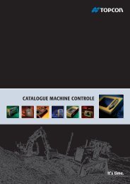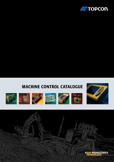
MACHINE CONTROL CATALOGUE - Topcon Positioning
MACHINE CONTROL CATALOGUE - Topcon Positioning
MACHINE CONTROL CATALOGUE - Topcon Positioning

Create successful ePaper yourself
Turn your PDF publications into a flip-book with our unique Google optimized e-Paper software.
<strong>MACHINE</strong> <strong>CONTROL</strong> <strong>CATALOGUE</strong>
Introduction<br />
<strong>Topcon</strong> jobsite automation – for a profitable site<br />
<strong>Topcon</strong> is a worldwide leading manufacturer of positioning<br />
and control instruments and continues to set the world<br />
standard of precision positioning. <strong>Topcon</strong> aims at always<br />
improving the accuracy, durability and affordability in<br />
equipment for machine control and automation in construction.<br />
<strong>Topcon</strong>’s product portfolio includes a wide variety of everything<br />
from optical measuring instruments and rotating<br />
lasers to machine control devices and satellite positioning<br />
equipment. All <strong>Topcon</strong> machine control products are scalable<br />
and upgradeable.<br />
Regardless of the type of machine you use, <strong>Topcon</strong> has a<br />
machine control product that will reduce the set-up time<br />
and down-time significantly. All in order to provide you with<br />
modular and seamless state of the art jobsite management<br />
solutions that improve the savings, productivity, quality and<br />
management on your jobsite significantly.<br />
Cost reductions – Less wear and tear on machinery as<br />
well as less working hours. Optimization of material usage<br />
through high accuracy automatic control and reduction or<br />
even elimination of staking and engineering costs.<br />
Productivity increase – Nearly continuous production.<br />
Doubled, tripled or even quadrupled productivity, and the<br />
use of only the required amount of materials.<br />
Quality increase – You will be able to work with the highest<br />
possible precision. Parameters such as quality and accuracy<br />
are equally high on the whole jobsite and the risk<br />
of human errors and need to re-work parts of the job is<br />
eliminated.<br />
Site Management – Knowing where your machines are,<br />
planning your fleet maintenance, enabling direct communication<br />
between office and machines, monitoring productivity<br />
and real time insight of the construction status. You<br />
will be able to manage, support and check your entire site<br />
directly from your office or mobile.<br />
Index of contenT<br />
Page 2<br />
Page 3<br />
Page 4-5<br />
Page 6-7<br />
Page 8-9<br />
Page 10-11<br />
Page 12-13<br />
Page 14-15<br />
Introduction<br />
Technologies<br />
Jobsite Control with <strong>Topcon</strong><br />
Excavator Systems<br />
Dozer Systems<br />
Motor Grader Systems<br />
Paver Systems<br />
Site Management<br />
This <strong>Topcon</strong> Machine Control catalogue will guide you<br />
through all solutions that we have available for you to<br />
improve your business. Solutions for single machines and<br />
solutions for your entire job site.<br />
2
Technologies<br />
Overview of technologies used in <strong>Topcon</strong> Machine Control solutions<br />
2D <strong>Positioning</strong> – The most basic 2D control system uses<br />
the reference of a laser or sonic transmitter to set the blade,<br />
bucket or screed of your machine. Display indicators show<br />
the operator in which direction to move the bucket or<br />
blade to get “on-grade”. 2D systems immediately eliminate<br />
the need of external grade checkers working around the<br />
machine.<br />
3D <strong>Positioning</strong> – With 3D machine control the engineers’<br />
designs are directly loaded on a computer in the cabin of<br />
the machine. The system continuously measures its actual<br />
position and compares this to the design data. The difference<br />
between the two is automatically corrected via the<br />
machines’ hydraulics. Different sensors are available, like Total<br />
Stations, GPS+ (GPS + GLONASS), mmGPS and 3DMC 2 .<br />
LPS – When satellites are not visible, for instance when<br />
working in a tunnel or dense build areas, Local Position System<br />
(LPS) is the right choice. LPS uses a traditional survey<br />
robotic total station to calculate the machines coordinates.<br />
Technologies<br />
Millimeter GPS – The mmGPS system will give you mm<br />
accuracy. By setting up a Laser Zone transmitter and sensor<br />
on the machine, you finish grade with all benefits of<br />
GPS+ and the accuracy of a Total Station. mmGPS gives you<br />
the flexibility to use multiple machines and survey crews<br />
with the same reference at the same site.<br />
3DMC 2 – Twice as fast, twice as accurate, 3DMC 2 will drastically<br />
change the role your machine plays on a typical site. It<br />
will allow you to use it more efficiently. Along with increased<br />
speed, 3DMC 2 means fewer passes resulting in much more<br />
work done in less time, with less fuel and less machine wear.<br />
SiteLink3D – is the first jobsite management system to<br />
provide site communication, complete data control, remote<br />
support and a reporting system in one. Combine all information<br />
across the line for up to date information on the progress<br />
of a project. Share it throughout the process, connect<br />
your entire fleet.<br />
3
Jobsite Control with <strong>Topcon</strong><br />
Complete jobsite Control with <strong>Topcon</strong> Machine Control Systems<br />
Every construction jobsite is like operating a manufacturing<br />
process, with different steps and phases, all closely related<br />
and the next depending on the previous.<br />
The key to optimize the entire flow of activities in this<br />
process – to increase productivity and to reduce operating<br />
costs – is the automation of positioning and control work<br />
on your jobsite.<br />
<strong>Topcon</strong> offers a complete suite of state-of-the-art solutions<br />
to manage your jobsite data and to efficiently run your<br />
production process, from automated control systems on<br />
your machinery and efficient use of survey data, to integration<br />
of survey staking work with actual execution.<br />
Indicate GPS<br />
3D<br />
clearing<br />
DESIGN – OPERATION – <strong>CONTROL</strong><br />
3D mmGPS<br />
paving<br />
3D mmGPS<br />
finish base material<br />
3<br />
Design and <strong>Positioning</strong> standard – In almost any industry<br />
CAD has long been the standard. Even in construction, it<br />
is used to create all site and building plans. This holds true<br />
from early stage in tendering, bidding and planning to daily<br />
operation, grade checking and job site volume calculations.<br />
3DMC 2<br />
3D GPS<br />
place base material<br />
Where CAD is the standard in design, GPS+ (GPS + GLO-<br />
NASS) is the standard in positioning. Nowadays a GPS+<br />
infrastructure is built on the construction site to ensure that<br />
all parties have accurate positions.<br />
<strong>Topcon</strong> offers solutions that are dedicated for every<br />
construction phase. Perfect for each phase in the execution<br />
process, they also keep the connection to the entire project.<br />
Where GNSS or CAD is not available, <strong>Topcon</strong> instead brings<br />
you tailor made solutions.<br />
<strong>Topcon</strong> Machine Control Technology solutions overview of<br />
Excavator and Dozer Systems<br />
MC Systems Excavator Dozer<br />
2D Laser l l<br />
3D GPS+ l l<br />
3D LPS<br />
l<br />
3D mmGPS<br />
l<br />
3D MC 2<br />
l<br />
4
Jobsite Control with <strong>Topcon</strong><br />
3D GPS<br />
surveying, planning<br />
and managing<br />
Project phases – Each phase of the process has its own<br />
character. Clearing, rough grading, excavating, fine grading,<br />
finishing and paving – all related to each other even though<br />
clearly different types of machines are used. And in spite of<br />
having specific needs, technologies and users, the machines<br />
work together on one goal: to finish the job as soon and as<br />
accurate as possible.<br />
The secret of dedicated solutions with an eye for the whole<br />
project is in the flexible usage of the same components on<br />
different machines. <strong>Topcon</strong> machine control systems are<br />
built up with the same components, creating exchangeable<br />
units that can go from one machine to the other. Besides<br />
exchanging are all systems upgradeable back and forth. This<br />
is unique and guarantees your investment.<br />
D<br />
3D Indicate GPS<br />
roughing in subgrade<br />
3D Indicate GPS<br />
excavation and utilities<br />
SYSTEMS<br />
3DMC 2<br />
3D GPS<br />
finish subgrade<br />
The further the jobsite proceeds, the more valuable the<br />
resources and the more accurately the machines need to<br />
operate. It is logical to use the existing site positioning infrastructure<br />
for the different project phases.<br />
<strong>Topcon</strong> Machine Control Technology solutions overview of<br />
Grader and Paver Systems<br />
Each phase and machine uses 3D GPS+ positioning. Add<br />
mmGPS for accuracy or MC 2 for speed when needed.<br />
MC Systems Grader Paver<br />
2D Laser/Sonic l l<br />
3D GPS+<br />
l<br />
3D LPS l l<br />
3D mmGPS l l<br />
3D MC 2<br />
l<br />
5
Excavator Systems – 2D Laser · 3D GPS+<br />
Excavator Control Systems<br />
An excavator is a special machine to control as it is used in<br />
excavating work, material overhaul and even fine grading.<br />
All moving parts need to be measured, which is done via<br />
highly accurate rotation sensors that are mounted on safe<br />
places on boom, stick and bucket. <strong>Topcon</strong> offers both upgradeable<br />
2D and 3D solutions.<br />
With <strong>Topcon</strong>’s excavator systems you will “get to grade”<br />
faster, be more accurate and therefore save time, material<br />
and money. This goes especially for jobs such as road<br />
construction, landfill slopes, underwater digging and other<br />
earth-moving applications. It will not only help the operator<br />
in finishing, but also the logistic planning of dump trucks will<br />
be more consistent.<br />
All <strong>Topcon</strong> machine control products are scalable and upgradeable.<br />
On top of this, all construction machinery using<br />
<strong>Topcon</strong> 3D systems are interfaced with the same software.<br />
Excavators, dozers, motor graders, wheel loaders, pavers<br />
and even survey crews – all work with the same user-friendly<br />
software.<br />
GPS+ Application 2D Laser 3D GNSS<br />
Infrastructure Road l l<br />
Rail l l<br />
Airport l l<br />
Site Parking lot l l<br />
Landfill Refuse dump (l) l<br />
Landscaping Golf course (l) l<br />
Bucket Control Systems<br />
X-22: 2D Indicate Laser System<br />
X-62: 2D Indicate Laser System (3D Ready)<br />
With <strong>Topcon</strong> 2D indicate systems different<br />
profiles and slopes can be entered directly<br />
into the cabins display. This eliminates delay<br />
as well as the frustration of constantly having to check control<br />
points or wait for a grade checker.<br />
With additional tilt bucket sensor and compass, slopes, profiles<br />
and flat surfaces can be excavated fast and accurate<br />
in any bucket or excavator position. You can<br />
choose from several references, such as an existing<br />
surface, a previous cut, stakes or a rotating laser.<br />
0.50m<br />
0.40m<br />
0.30m<br />
0.20m<br />
0.10m<br />
0.00m<br />
0.10m<br />
0.20m<br />
0.30m<br />
<strong>Topcon</strong> 3D Excavator system combines the<br />
advantages of our industry-leading GPS+<br />
(GPS + GLONASS) technology together with<br />
our industry standard operator interface. With the display,<br />
the final grade and current bucket position, is clearly visible.<br />
The cut/fill indicator clearly guides the operator to grade<br />
with a graphical colour indicator.<br />
6
Excavator Systems – 2D Laser · 3D GPS+<br />
Dozer SYSTEMS<br />
X-63: 3D Indicate GPS+ System<br />
Network Ready – When a GPS+ reference network or<br />
TopNET live service is available, the machine receiver is able<br />
to pick up the correction signals up using GSM and N-Trip.<br />
Via this way a base station is eliminated and the excavator<br />
system is even more flexible.<br />
7
Dozer Systems – 2D Laser · 3D LPS · 3D GPS+ · 3D mmGPS · 3DMC 2<br />
Dozer Control Systems<br />
Your dozer appears in the process where mass material<br />
needs to be spread; usually at sub-base level. To automate<br />
dozers, <strong>Topcon</strong> offers both 2D and 3D solutions. With these<br />
systems, you will eliminate over-cutting and keep control<br />
over material usage, saving you time and money. With<br />
a dozer control system the operator is really in control.<br />
With <strong>Topcon</strong> dozer systems you will dramatically increase<br />
the jobsite’s productivity. Especially in accurate dozer<br />
spreading they might eliminate the need for motor graders<br />
in the next phase and therefore shorten the earth moving<br />
train.<br />
All dozer control systems are part of a modular system. And<br />
all <strong>Topcon</strong> machine control solutions are upgradeable back<br />
and forth. On top of this, all construction machinery using<br />
3D systems are interfaced with the same software.<br />
Application 2D Laser 3D LPS 3D GNSS 3D mmGPS 3DMC 2<br />
Infrastructure Road l l l l l<br />
Rail l l l l l<br />
Airport l l l l l<br />
Site Parking lot l l l l l<br />
Landfill Refuse dump (l) l l l l<br />
Landscaping Golf course (l) l l l l<br />
Blade Control Systems<br />
Z-52: 2D Laser System<br />
i-33: 3D Indicate GPS+ System<br />
Z-63: 3D mmGPS System<br />
<strong>Topcon</strong>’s 2D dozer laser system represents<br />
a giant leap in dozer grade control. The<br />
laser control system includes a 100%<br />
slope sensor to measure the blade’s slope, in case one<br />
laser receiver is used. When using two masts and two<br />
laser receivers the slope sensor is not needed. The<br />
control box presents the desired slope and elevation<br />
to the operator and sends corrections directly to the<br />
machine’s hydraulics.<br />
<strong>Topcon</strong>’s 3D control features GPS+ dual<br />
constellation. It includes a 100% slope sensor<br />
to measure the blade’s slope, in case one<br />
receiver is used. Ideal for long runs and smooth turns.<br />
With two masts and two GPS+ receivers the slope sensor is<br />
not needed and you will get control over fast forward and<br />
backward movements as well as short curves.<br />
2D gives you the flexibility to use reference to<br />
work from: existing surface, a point, a previous<br />
cut, a predefined slope or a rotating laser.<br />
It’s as simple as switching on a laser.<br />
8
Dozer Systems – 2D Laser · 3D LPS · 3D GPS+ · 3D mmGPS · 3DMC 2<br />
3D mmGPS control can be used in case<br />
millimeter accuracy is required, featuring<br />
<strong>Topcon</strong>’s unique Lazer Zone technology. By<br />
setting up the Lazer Zone transmitter and sensor on your<br />
dozer, you will increase the accuracy of the GPS+ elevation<br />
to millimeter level and finish grade with all the benefits of<br />
GPS+ flexibility and the accuracy of a Total Station.<br />
Grader SYSTEMS<br />
Z-63: 3D MC 2 System<br />
DOZER System MAIN Components<br />
2D Laser 3D LPS 3D GPS+ 3D mmGPS 3DMC 2<br />
Laser receiver Prism 360° GPS+ antenna GPS+ antenna plus GPS+ antenna<br />
Radio Radio Radio Radio<br />
MC-R3 receiver MC-R3 receiver MC-R3 receiver MC-R3 receiver<br />
Control box Graphical display Graphical display Graphical display Graphical display<br />
Automatic switch Automatic switch Automatic switch Automatic switch Automatic switch<br />
Hydraulic valve Hydraulic valve Hydraulic valve Hydraulic valve Hydraulic valve<br />
Slope sensor Slope sensor Slope sensor Inertial sensor<br />
Laser transmitter Total station Base station or Base station or Base station or<br />
TopNET live TopNET live TopNET live<br />
Increase dozer fine grading speed<br />
by up to 200% over existing 3D<br />
systems and up to 400% over<br />
uncontrolled machines! 3DMC 2 provides position updates<br />
at a rate of 100 times per second. Smoothness and grading<br />
accuracy are comparable to motor graders.<br />
9
Motor Grader Systems – 2D Laser · 2D Sonic · 3D LPS · 3D GPS+ · 3D mmGPS<br />
Motor Grader Control Systems<br />
The motor grader’s purpose is to finish grade of the rough<br />
grading carried out by heavy equipment as scrapers and<br />
bulldozers. To automate motor graders, <strong>Topcon</strong> offers both<br />
2D and 3D solutions. With these systems, you will finish off<br />
the sub-base and prepare your site for the final phase in the<br />
most accurate way.<br />
With motor grader systems you will increase the jobsite’s<br />
productivity, especially when stakes or stringlines are eliminated.<br />
3D design models replace the stakes and stringlines<br />
into a digital form and create an optimum flow between the<br />
motor grader and other machines.<br />
All <strong>Topcon</strong> motor grader control solutions are upgradeable<br />
back and forth, using the same slope, rotation and mainfall<br />
sensors. Investing in a <strong>Topcon</strong> motor grader system guarantees<br />
years of control.<br />
Application 2D Laser/Sonic 3D LPS 3D GNSS 3D mmGPS 3D MC 2<br />
Infrastructure<br />
Dirtroad l l l l l<br />
Road l l l l l<br />
Highway l l l l l<br />
Rail l l l l l<br />
Airport l l l l l<br />
Main 2D Sonic components<br />
Blade Control Systems<br />
G-52: 2D Laser System<br />
G-63: 3D Total Station System<br />
G-63: 3D GPS+ System<br />
<strong>Topcon</strong>’s 2D grader laser system represents<br />
a giant leap in motor grader grade control. It<br />
features System V laser control for smooth,<br />
consistent hydraulic response. The 2D motor grader laser<br />
is also fully upgradeable to any <strong>Topcon</strong> 3D motor grader<br />
system.<br />
You can also add a sonic tracker to your machine.<br />
With the arrow indicators you will have an indicate<br />
system. When connecting this directly to your<br />
control box and hydraulics you automatically<br />
control the motor grader’s<br />
blade. Imagine the finishing<br />
speed this will give you!<br />
Adding 3D position and elevation to the<br />
blades’ slope enables finishing complex 3D<br />
models and road alignments in no time.<br />
The 3D LPS control forms the most flexible solution for complete<br />
automatic motor grader control and advanced robotic<br />
survey. The position and millimeter elevation is constantly<br />
sent to the machine’s control box via high speed radio link.<br />
<strong>Topcon</strong>’s 3D GPS+ control provides you with a 3D position<br />
at any time at any place. The software is intuitive and the<br />
hydraulic response smooth and consistent.<br />
10
Motor Grader Systems – 2D Laser · 2D Sonic · 3D LPS · 3D GPS+ · 3D mmGPS<br />
3D mmGPS control is used in case millimeter<br />
accuracy is required. By setting up the<br />
Lazer Zone transmitter and sensor on<br />
the machine, you will increase the accuracy of the GPS+ elevation<br />
to laser level and finish grade with all the benefits of<br />
GPS+ flexibility and the accuracy of a Total Station.<br />
Paver SYSTEMS<br />
G-63: 3D mmGPS System<br />
Grader System MAIN Components<br />
2D Sonic 2D Laser 3D LPS 3D GPS+ 3D MC 2 3D mmGPS<br />
Sonic tracker Laser receiver Prism 360° GPS+ antenna GPS+ antenna mmGPS receiver<br />
Radio Radio Radio Radio<br />
Mainfall Mainfall Mainfall Mainfall Mainfall Mainfall<br />
MC-R3 receiver MC-R3 receiver MC-R3 receiver MC-R3 receiver<br />
2D Control box 2D Control box Graphical display Graphical display Graphical display Graphical display<br />
Automatic switch Automatic switch Automatic switch Automatic switch Automatic switch Automatic switch<br />
Hydraulic valve Hydraulic valve Hydraulic valve Hydraulic valve Hydraulic valve Hydraulic valve<br />
Slope sensor Slope sensor Slope sensor Slope sensor Inertial sensor Slope sensor<br />
Rotation sensor Rotation sensor Rotation sensor Rotation sensor Rotation sensor Rotation sensor<br />
String line or other reference Laser Transmitter Total Station Base station or Base station or Base station or<br />
TopNET live TopNET live TopNET live<br />
11
Paver Systems – 2D Laser · 2D Sonic · 3D LPS · 3D mmGPS<br />
Paver Control Systems<br />
Spreading material with a paver in the last phase is different<br />
from spreading material in earlier stages, as material and<br />
mistakes are extremely expensive. Therefore it is critical to<br />
have the right system to achieve the job.<br />
Your paver and paving job dictates which system offers you<br />
the most. <strong>Topcon</strong>’s 3D paving solutions are developed to assist<br />
with complex designs, where 2D paving solutions assist<br />
for smaller sites .<br />
Especially using 3D mmGPS the benefit is very clear. Eliminating<br />
string lines, decreasing the dismantling of road barriers,<br />
simplifying truck logistics, increasing paving accuracy<br />
and simply getting it right at the first time are all direct effects<br />
of automating your paver.<br />
Application 2D Laser 2D Sonic 3D LPS 3D mmGPS<br />
Infrastructure Road (l) l l l<br />
Rail (l) l l l<br />
Airport (l) l l l<br />
Site Parking lot l l l l<br />
Sportfield l l l l<br />
Screed Control Systems<br />
P-32: 2D Laser System<br />
P-32: 2D Sonic System<br />
<strong>Topcon</strong>’s 2D paver laser system represents<br />
the first step in automating your paver. It<br />
features System V laser control for smooth,<br />
consistent hydraulic response. The 2D paver laser is also<br />
fully upgradeable to any <strong>Topcon</strong> 3D paver system.<br />
Besides a laser you can also add a sonic tracker to your<br />
machine. With the arrow indicators it is an indicate system.<br />
When connecting this directly to your control box and hydraulics<br />
you automatically control the paver’s screed. Imagine<br />
the finishing speed this will give you!<br />
12
Paver Systems – 2D Laser · 2D Sonic · 3D LPS · 3D mmGPS<br />
3D-LPS Paver control system – A standard<br />
survey Total Station measures continuously<br />
the position of the screed and sends this over<br />
to the operator’s control box. This robotic Total Station has<br />
been the standard for surveys, and this proven technology<br />
is now used for machine control. So LPS forms the most<br />
flexible solution for complete automated paver control and<br />
advanced robotic surveys with the highest precision.<br />
P-63: 3D LPS System<br />
Software and more<br />
P-63: 3D mmGPS System<br />
Highest precision with mmGPS – <strong>Topcon</strong>’s<br />
industry-leading mmGPS precise positioning<br />
technology has been expanded into the<br />
paving industry, creating the world’s first 3D-GPS control<br />
system for pavers, profilers and trimmers.<br />
<strong>Topcon</strong>’s unique technology provides a significant enhancement<br />
in the vertical precision of GPS. The technology,<br />
known as Laser Zone, is used by hundreds of companies<br />
worldwide to generate a vertical accuracy to within a few<br />
millimeters as compared to the centimeter vertical accuracy<br />
of conventional RTK GPS.<br />
Utilized on pavers, the Millimeter GPS technology incorporates<br />
a unique zone-beam laser transmitter, which sweeps<br />
a 600 m area with a 10m high wall of laser light. A compact<br />
sensor is mounted on a mast which is attached to the toe<br />
arm of the paver. Any time the MC sensor is positioned<br />
within the laser zone signal, the system provides millimeter<br />
vertical precision.<br />
13
Site Management<br />
The ultimate job site management tool<br />
SiteLink3D connects all parts of<br />
a construction site together – people,<br />
data, devices, machines – no<br />
matter where they are. It’s the one system that provides<br />
construction companies with a way to manage their projects<br />
and resources effectively. It provides communication,<br />
management and collaboration tools that shows real-time<br />
site status and improves planning.<br />
What drives the system? - At the heart of the system is<br />
the Enterprise cloud server that manages data and services.<br />
Data and services are securely separated by customer organization<br />
and through comprehensive user-access controls.<br />
SiteLink3D provides reliable and secure connections<br />
through communication networks with guaranteed quality<br />
of service.<br />
As well as data synchronization and distribution, the<br />
SiteLink3D enterprise solution provides powerful site analytics<br />
functions. SiteLink3D constantly measures site progress<br />
through volumetric monitoring and can provide realtime<br />
and ad-hoc volume analysis reports.<br />
Site Management<br />
The idea stemmed from the need to conveniently exchange<br />
data between the office and machines, and onsite construction<br />
workers, surveyors and the office. The mining industry<br />
was an early market adopter more for the sake of safety<br />
rather than convenience. This still applies. Beyond straightforward<br />
data exchange came the opportunity to monitor<br />
and measure machine operations and performance and<br />
productivity especially in the mining sector. With the availability<br />
of high-speed cellular networks almost everywhere,<br />
the construction sector now too can enjoy the convenience<br />
of remote data management and the cost and time-saving<br />
benefits of quantified site metrics.<br />
Real-time overview - The smart thing of SiteLink3D is<br />
that it tracks the real-time as-built surface, the only system<br />
that has this feature. The system keeps a real-time<br />
update of the current state of the job site and the surface.<br />
It can track surface volumes and can exactly calculate how<br />
much dirt already is moved and how much more there is<br />
to move and presents this to those that need it; site manager,<br />
surveyor and operator. It also provides data on progress,<br />
performance and productivity. Out of this data the<br />
project manager can adjust job site schedules and make<br />
changes that can be directly distributed to the machines<br />
from any location. And, by using the productivity element of<br />
SiteLink3D, you can analyze the site´s progress and you will<br />
actually visualize specific areas where time was lost.<br />
14
Site Management<br />
Site communication - Every person connected with<br />
SiteLink3D is able to communicate and collaborate remotely,<br />
no matter where they are.<br />
Fewer people will need to waste time driving around the<br />
job site, stopping the work to update information as sending<br />
files and communicating with the work crews is done<br />
directly on the control box or field computer. It increases<br />
visibility and transparency and eliminates problems related<br />
to remote job sites.<br />
Cloud data - SiteLink3D uses a seamless cloud model for<br />
data warehousing and distribution. Data servers and web<br />
portals are deployed geographically based on user demand<br />
across all continents. By separating data and web services,<br />
SiteLink3D sets the benchmark for job site communications<br />
and project data management and provides an open<br />
architecture for contractors, sub-contractors, surveyors,<br />
engineers, OEMs and third-party participants in projects to<br />
share data and services.<br />
Site Management<br />
Comparing SiteLink3D to anything in today’s mushroom<br />
cloud of technology is like a combination of Mail Service,<br />
chat, Messanging, Screen Sharing, Task Managament and<br />
Scheduling.<br />
SiteLink3D: It’s the link that combines the<br />
best out of all those into one product that<br />
has unlimited applications on every job<br />
sites.<br />
15
About Us<br />
With over 80 years worth of experience in the manufacture,<br />
distribution and support of products, <strong>Topcon</strong> is<br />
well placed to offer comprehensive support to cater for<br />
all your needs.<br />
Established in 1932, <strong>Topcon</strong> today is represented by a<br />
workforce of over 6,000. <strong>Topcon</strong> developes, manufactures,<br />
sells, and provides services for a wide range of<br />
high technology products for the capture, analysis and<br />
presentation of spatial data in the macro, micro and nano<br />
worlds.<br />
Investment in research and development leading to innovative<br />
new solutions and products is key to the <strong>Topcon</strong><br />
philosophy and is evident in a number of industry firsts<br />
that include the first coaxial EDM Total Stations, the<br />
GTS-1 and the unique GPT-7000i series imaging Total<br />
Stations incorporating digital cameras.<br />
Additionally, <strong>Topcon</strong> has produced the first and<br />
only available mmGPS system, and is the first to<br />
offer a true GNSS (Global Navigation Satellite System);<br />
dual frequency, dual constellation, GPS plus GLONASS<br />
satellite receivers.<br />
<strong>Topcon</strong> developed inertial sensors to further improve<br />
stability with fast blade movements on dozers and motor<br />
graders.<br />
Recently <strong>Topcon</strong> introduced cloud-based management<br />
for survey and construction.<br />
www.topcon.eu<br />
Your local authorized <strong>Topcon</strong> distributor is:<br />
* Designs and specifications are subject to change without notice. T400EN - English - C<br />
grafit-werbeagentur.de