Burwash Walk - East Sussex County Council
Burwash Walk - East Sussex County Council
Burwash Walk - East Sussex County Council

You also want an ePaper? Increase the reach of your titles
YUMPU automatically turns print PDFs into web optimized ePapers that Google loves.
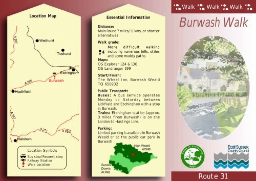
Route 31<br />
Location Map<br />
Location Symbols<br />
Bus stop/Request stop<br />
Railway Station<br />
<strong>Walk</strong> Location<br />
Essential Information<br />
Distance:<br />
Main Route 7 miles/11 kms, or shorter<br />
alternatives<br />
<strong>Walk</strong> grade:<br />
More difficult walking<br />
4 including numerous hills, stiles<br />
and some muddy paths<br />
Maps:<br />
OS Explorer 124 & 136<br />
OS Landranger 199<br />
Start/Finish:<br />
The Wheel Inn, <strong>Burwash</strong> Weald<br />
TQ 650232<br />
Public Transport:<br />
Buses: A bus service operates<br />
Monday to Saturday between<br />
Uckfield and Etchingham with a stop<br />
in <strong>Burwash</strong>.<br />
Trains: Etchingham station (approx.<br />
3 miles from <strong>Burwash</strong>) is on the<br />
London to Hastings Line.<br />
Parking:<br />
Limited parking is available in <strong>Burwash</strong><br />
Weald or at the public car park in<br />
<strong>Burwash</strong><br />
<strong>Walk</strong> <strong>Walk</strong> <strong>Walk</strong><br />
<strong>Burwash</strong> <strong>Walk</strong>
Paths to Prosperity<br />
<strong>East</strong> <strong>Sussex</strong> is a welcome haven for walkers<br />
in the busy south-east of England, with over<br />
two thirds of the <strong>County</strong> covered by the High<br />
Weald and <strong>Sussex</strong> Downs Areas of<br />
Outstanding Natural Beauty.<br />
There is also a wealth of picturesque villages,<br />
country houses and parkland hidden within<br />
its rolling landscape, waiting to be<br />
discovered.<br />
Please come and enjoy the unique splendours<br />
of our countryside, but please also support<br />
the local businesses that help make the<br />
countryside the vibrant place that it is today.<br />
The Countryside Code<br />
• Be Safe - plan ahead and follow any signs<br />
• Leave gates and property as you find them<br />
• Protect plants and animals, and take your<br />
litter home<br />
• Keep dogs under close control<br />
• Consider other people<br />
Tourist Information Centre<br />
Battle Abbey, High Street, Battle<br />
Tel: 01424 773721<br />
Fax: 01424 773436<br />
email: battletic@rother.gov.uk<br />
The information contained in this leaflet was correct<br />
at the time of printing (December 2005)<br />
1<br />
2<br />
3<br />
4<br />
5<br />
6<br />
7<br />
8<br />
9<br />
10<br />
11<br />
Refreshments and<br />
Local Services<br />
(see map for location)<br />
The Wheel Inn<br />
Public House - 01435 882758<br />
Woodlands Farm<br />
Bed & Breakfast Accommodation -<br />
01435 882794<br />
<strong>Burwash</strong> Newsagents & Post Office<br />
Post Office and Newsagents - 01435 882217<br />
Chateau Briand Antiques<br />
Antique Shop - 01435 882535<br />
Chateau Briand Bed & Breakfast<br />
Bed & Breakfast Accommodation -<br />
01435 882535<br />
Church House<br />
Bed & Breakfast Accommodation -<br />
01435 883282<br />
The Bear Inn & <strong>Burwash</strong> Motel<br />
Public House & accommodation -<br />
01435 882540<br />
Lime Tree Tea Rooms<br />
Restaurant - 01435 882221<br />
Wealden Ironcrafts<br />
Blacksmiths - 01435 883422<br />
FJ Jarvis & Sons<br />
Local Family Butcher - 01435 882213<br />
Batemans<br />
National Trust Property - 01435 882302<br />
Please note that inclusion of business details in this<br />
leaflet does not constitute an endorsement of the<br />
business by <strong>East</strong> <strong>Sussex</strong> <strong>County</strong> <strong>Council</strong> or its agents.<br />
We hope that you enjoy the walk in this<br />
leaflet, which is one of a series produced<br />
by <strong>East</strong> <strong>Sussex</strong> <strong>County</strong> <strong>Council</strong>.<br />
Copies of the leaflets for other walks in<br />
the series are available from Tourist<br />
Information Centres and libraries or<br />
direct from <strong>East</strong> <strong>Sussex</strong> <strong>County</strong> <strong>Council</strong>,<br />
by contacting the Rights of Way Team:-<br />
By phone on:-<br />
01273 482250 / 482354 / 482324<br />
By post at:-<br />
Transport and Environment Department<br />
<strong>County</strong> Hall<br />
St. Anne’s Crescent<br />
Lewes BN7 1UE<br />
By e-mail at:-<br />
rightsofway@eastsussex.gov.uk<br />
By downloading from the website at:-<br />
www.eastsussex.gov.uk<br />
If any problems are encountered on the<br />
walk please report them to the above<br />
contact points.<br />
This can be completed as a whole route at a<br />
distance of approximately 7 miles/11 km, or<br />
as one of two shorter routes. A medium length<br />
walk of 5 miles/8 kms, can be undertaken, or<br />
a short walk of 3 miles/5 kms. The variations<br />
in route descriptions for the shorter walks are<br />
indicated in italic text with the main route<br />
description overleaf.
<strong>Burwash</strong> <strong>Walk</strong><br />
<strong>Burwash</strong><br />
<strong>Burwash</strong> was a small hamlet at the time of the<br />
Norman conquest slowly growing into the<br />
current village of just over 3,000<br />
inhabitants. The origins of the name<br />
<strong>Burwash</strong> are believed to have evolved<br />
from Burhercse in the 12th century<br />
through various changes over the<br />
centuries until arriving in the more<br />
familiar form of Burrishe in the<br />
16th century and <strong>Burwash</strong> in the<br />
17th. It is understood that in<br />
ancient English <strong>Burwash</strong><br />
means a “stronghold in a<br />
field”.<br />
<strong>Burwash</strong> Village<br />
The High Street includes<br />
a number of notable houses including Rampyndene on the<br />
southern side, a fine country house built in 1699 and on<br />
the northern side Chateaubriand which is thought to be<br />
the oldest house in the village built in around 1375.<br />
Map Legend<br />
Refreshments & Local Services<br />
(see over for details)<br />
Route<br />
Other Public Footpaths<br />
Other Public Bridleway<br />
Reproduced from<br />
the Ordnance Survey<br />
Mapping with the<br />
permission the Controller<br />
of H. M. Stationery Office.<br />
Crown Copyright.<br />
Unauthorised reproduction<br />
infringes Crown Copyright and may<br />
lead to prosecution or civil proceedings.<br />
<strong>East</strong> <strong>Sussex</strong> <strong>County</strong> <strong>Council</strong> - 100019601,<br />
2005.<br />
0.5miles<br />
0<br />
1km
Starting from the Wheel Inn Public House in <strong>Burwash</strong> Weald, turn left and follow the main road for a<br />
distance of approximately 450 metres (500 yds.) before turning left onto the signposted bridleway<br />
opposite Weald House. Follow the bridleway past Green Farm and turn right at the junction of tracks<br />
to follow the signposted bridleway for a total distance of approximately 2 km (1 1 / 4<br />
miles). This long<br />
enclosed section of the route, passes to the rear of Woodlands Farm along Holton Lane. At the end of<br />
the bridleway, turn left on to Spring Lane and after a short distance, turn right onto the signposted<br />
footpath along the driveway. At the next signposted path junction, turn right to follow the footpath<br />
through the field gate. After a short distance follow the waymarked route to join the drive. Follow<br />
the drive passing the entrance to Mottynsden House, and continue ahead through the field gate as<br />
waymarked. Follow the field edge path to a footbridge, and then through the field gate. Continue<br />
along the edge of the next field, before turning right across a short footbridge. Follow the waymarked<br />
route, keeping the hedge to left. Cross the stile to the left of the house to join the driveway, and<br />
follow to the main road at <strong>Burwash</strong>.<br />
A typical High Weald view near the walk<br />
Turn left, to follow the road into <strong>Burwash</strong> Village, and turn right into the main car park. Follow the route heading to the left of the Scout Hut in the<br />
corner of the car park. Follow the path past the garden and then downhill along the field edge. Turn right at the next footpath junction to cross the<br />
boardwalk. Continue along the path ahead, to the stile in the field corner. Follow the short enclosed path, and continue along the edge of the next field.<br />
From the next stile, cross the field diagonally to a pond. From the pond, follow the field edge to Batemans Lane.<br />
Turn right and follow the lane to its junction in front of Batemans House. Turn left and then right immediately after Corner Cottage to follow the<br />
path around the mill pond. Follow the path beside the stream, and continue ahead, ignoring the path over the bridge on your right. Continue ahead<br />
through a kissing gate, and follow the hedge on your left to a gate. Continue along the signposted route to a further gate and across a field climbing<br />
the steep hill and into the woodland. Beyond the wood, follow the field edge path, crossing a number of stiles to reach Willingford Lane. To complete<br />
the medium length walk, turn right and follow Willingford Lane back to the Wheel Inn.<br />
To start the short walk, from the Wheel Inn, cross the main road and follow Willingford Lane for a distance of 1 km ( 2 / 3<br />
mile) to join the main walk just<br />
after Willingford Bridge.<br />
To continue on the main walk, cross the lane, to follow the signposted bridleway to the left of Willingford Farm, and on to a field gate in the top right<br />
hand corner of the field. Continue through a wood to a field gate, then follow the waymarked path, crossing a number of fields to reach a hand gate<br />
leading onto the woodland path. Follow the well defined path through the woodland for a distance of 570<br />
metres (625 yds.) to a path junction. Turn right to follow the bridleway towards Glaziers Forge. Turn right onto<br />
the drive and past the houses at Glaziers Forge, before turning right at the signposted junction, onto the<br />
footpath. Cross the field, keeping to the right of the farm buildings to a stile. Cross the next field to a gap in<br />
the fence, then bear right across the next field to reach a large footbridge. Follow the waymarked path up hill,<br />
from the bridge, crossing two fields, and then along the edge of the next field, continuing straight ahead at the<br />
path junction. Cross another stile, and follow the path through the wood, and on towards Henhurst Farm. Follow<br />
the signposted path to the right, around Henhurst Farm and then along the drive. After passing a barn,<br />
continue ahead along the signposted path rather than following the drive to the left. From the gate follow the<br />
field edge path steeply down hill to a stile, through the wood, and crossing a bridge, before following the well<br />
defined path leading back up hill to Willingford Lane. Turn left to return to the Wheel Inn and the end of the<br />
A view from the walk<br />
walk.<br />
Janina Holubecki/High Weald<br />
AONB Unit