INDIAN NOTICES TO MARINERS - National Hydrographic Office
INDIAN NOTICES TO MARINERS - National Hydrographic Office
INDIAN NOTICES TO MARINERS - National Hydrographic Office
You also want an ePaper? Increase the reach of your titles
YUMPU automatically turns print PDFs into web optimized ePapers that Google loves.
3.1<br />
SECTION – III<br />
TEMPORARY AND PRELIMINARY <strong>NOTICES</strong><br />
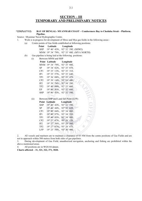
*225(P)/(17/12) BAY OF BENGAL- MYANMAR COAST – Combermere Bay to Cheduba Strait – Platform.<br />
Pipeline.<br />
Source: Myanmar Naval <strong>Hydrographic</strong> Centre.<br />
1. Work is in progress for development of Shwe and Mya gas fields in the following areas:-<br />
(a) Centre points of Gas fields established at following positions:<br />
Point Latitude Longitude<br />
SHP 19° 40´·43N., 92° 32´·59E. (SHWE)<br />
MNM 19° 34´·79N., 92° 35´·08E. (MYA NORTH)<br />
(b) Gas pipeline is being laid at the following positions:<br />
(i) Between MNM and SHP<br />
Point Latitude Longitude<br />
MNM 19° 34´·79N., 92° 35´·08E.<br />
SP 19° 34´·82N., 92° 35´·07E.<br />
CP1 19° 35´·13N., 92° 35´·31E.<br />
IP1 19° 35´·57N., 92° 35´·64E.<br />
TP1 19° 36´·08N., 92° 35´·47E.<br />
CP2 19° 39´·14N., 92° 34´·48E.<br />
IP2 19° 39´·76N., 92° 34´·28E.<br />
TP2 19° 40´·00N., 92° 33´·66E.<br />
EP 19° 40´·41N., 92° 32´·60E.<br />
SHP 19° 40´·43N., 92° 32´·59E.<br />
(ii)<br />
Between SHP and Land fall Point (LFP):<br />
Point Latitude Longitude<br />
SHP 19° 40´·43N., 92° 32´·59E.<br />
SP 19° 40´·44N., 92° 32´·62E.<br />
CP1 19° 40´·84N., 92° 34´·06E.<br />
IP1 19° 40´·97N., 92° 34´·51E.<br />
TP1 19° 40´·85N., 92° 34´·98E.<br />
CP2 19° 27´·47N., 93° 28´·12E.<br />
IP2 19° 27´·36N., 93° 28´·56E.<br />
TP2 19° 27´·07N., 93° 28´·87E.<br />
LFP 19° 25´·59N., 93° 30´·49E.<br />
2. All vessels and mariners are to maintain a clearance of 05 NM from the centre positions of Gas Fields and are<br />
not to approach within 500 metres from both sides of gas pipelines.<br />
3. During development of Gas Field, unauthorized navigation, anchoring and fishing are prohibited within the<br />
above mentioned areas.<br />
4. All positions are in WGS 84 datum.<br />
Charts affected – 31, 321, 322, 371, 3020.


