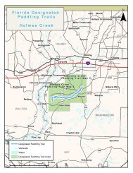
Pellicer Creek - Florida Department of Environmental Protection
Pellicer Creek - Florida Department of Environmental Protection
Pellicer Creek - Florida Department of Environmental Protection

Create successful ePaper yourself
Turn your PDF publications into a flip-book with our unique Google optimized e-Paper software.
<strong>Pellicer</strong> <strong>Creek</strong> <strong>Creek</strong><br />
Aquatic Preserve<br />
Location:<br />
St. Johns and Flagler counties<br />
Acreage:<br />
500 acres <strong>of</strong> sovereign submerged lands<br />
Key Accomplishments<br />
PRESERVE<br />
"Community leaders have preserved extensive areas in the watershed<br />
<strong>of</strong> the <strong>Pellicer</strong> <strong>Creek</strong> Aquatic Preserve resulting in one <strong>of</strong> the state’s<br />
most pristine freshwater, tidal creek and estuarine habitats. This<br />
Aquatic Preserve provides a unique setting to understand nature and<br />
to set goals for protecting other estuaries in the region."<br />
• Coastal and Aquatic Managed Areas (CAMA) coordinates with the DEP Regulatory program to ensure<br />
that <strong>Environmental</strong> Resource Permits and Submerged Land authorizations are as protective <strong>of</strong><br />
aquatic preserve resources as possible. CAMA can provide support to permit review staff through its<br />
resource staff familiar with preserves, boat access, GIS mapping, and field support.<br />
• Water quality, nutrients, and meteorological conditions are Local all monitored Contact: as part <strong>of</strong> the National<br />
Estuarine Research Reserve (NERR) System Wide Monitoring Michael Program. Shirley<br />
<strong>Environmental</strong> Administrator<br />
• CAMA partners with the St. Johns River Water Management GTMNERR District (SJRWMD), US Geological Survey<br />
(USGS), DEP Division <strong>of</strong> Recreation and Parks, Flagler County 505 Guana and other River Road agencies to conduct<br />
monitoring, research, and education programs in the watershed. Ponte Vedra Beach, FL 32082<br />
(904)823-4500<br />
• Coastal Training Programs have targeted water quality issues as well as habitat restoration efforts.<br />
www.aquaticpreserves.org<br />
Floating dock at Faver-Dykes State Park<br />
Coastal and Aquatic Managed Areas<br />
Aquatic Preserve Facts:<br />
• <strong>Pellicer</strong> <strong>Creek</strong> is one <strong>of</strong> the most pristine<br />
estuarine/riverine systems along <strong>Florida</strong>’s east<br />
coast<br />
• <strong>Pellicer</strong> <strong>Creek</strong> is protected by Faver Dykes State<br />
Park to the north and Princess Place Preserve and<br />
<strong>Pellicer</strong> <strong>Creek</strong> Conservation Area to the south.<br />
• <strong>Pellicer</strong> <strong>Creek</strong> Aquatic Preserve is designated as<br />
an Outstanding <strong>Florida</strong> Water.<br />
Aerial view <strong>of</strong> <strong>Pellicer</strong> <strong>Creek</strong><br />
•The submerged lands <strong>of</strong> the preserve include<br />
Project Spotlight<br />
Michael Shirley, Manager,<br />
saltwater marsh, brackish tidal creek, oyster<br />
Guana Tolomato Matanzas Modeling Flow-Ways<br />
bars, tidal mud flats, freshwater marsh and wet<br />
National Estuarine Research The historic Reserve lodge at Princess Place<br />
prairie.<br />
Preserve<br />
A flow-way is a center-line, representing concentrations <strong>of</strong> surface<br />
overland flow, running • <strong>Pellicer</strong> along <strong>Creek</strong> the ontains minimum one contour <strong>of</strong> the rare or elevation habitats for <strong>of</strong> the<br />
landscape flowing submerged from the upper aquatic elevations vegetation <strong>of</strong> the or seagrasses watershed in down a<br />
to the coastal waters.<br />
North<br />
GTM<br />
<strong>Florida</strong><br />
Research<br />
estuary.<br />
Reserve is working on a flow-way<br />
analysis for the <strong>Pellicer</strong> watershed to determine the natural flow<br />
•Both saltwater and freshwater species paths can be <strong>of</strong><br />
caught in Pelllicer <strong>Creek</strong>.<br />
surface water<br />
on the<br />
Nutrient monitoring<br />
landscape that<br />
drains into<br />
<strong>Pellicer</strong> <strong>Creek</strong><br />
Aquatic<br />
Preserve. This<br />
project will help<br />
guide plans for<br />
development<br />
within the<br />
watershed to<br />
protect coastal<br />
<strong>Pellicer</strong> <strong>Creek</strong> Aquatic Preserve<br />
Vegetated buffers along flow-ways protect water quality water quality by<br />
incorporating the concept <strong>of</strong> flow-ways into site plans. Identifying<br />
flow-ways can help protect core and buffer conservation areas to<br />
sustain and improve coastal water quality and habitat corridors.<br />
Other benefits can include: increased flood protection and mosquito<br />
control, protection <strong>of</strong> aquifer recharge areas and wildlife corridors,<br />
allow for habitat migration in response to sea level rise and create<br />
greenways and trails for passive recreation.<br />
A publication funded in part by the <strong>Florida</strong> <strong>Department</strong> <strong>of</strong> <strong>Environmental</strong> <strong>Protection</strong>, <strong>Florida</strong> Coastal<br />
Management Program, pursuant to National Oceanic and Atmospheric Administration Award No.<br />
NA04N0S4190035. The views expressed herein are those <strong>of</strong> the authors and do not necessarily<br />
reflect the view <strong>of</strong> the State <strong>of</strong> <strong>Florida</strong>, NOAA, or any <strong>of</strong> its sub-agencies.