Presentation - UC Davis Geology
Presentation - UC Davis Geology
Presentation - UC Davis Geology

You also want an ePaper? Increase the reach of your titles
YUMPU automatically turns print PDFs into web optimized ePapers that Google loves.
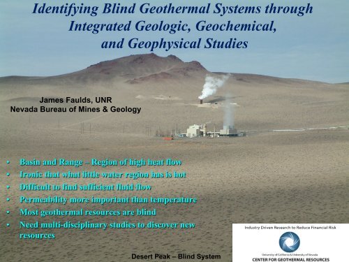
Identifying Blind Geothermal Systems through<br />
Integrated Geologic, Geochemical,<br />
and Geophysical Studies<br />
James Faulds, UNR<br />
Nevada Bureau of Mines & <strong>Geology</strong><br />
• Basin and Range – Region of high heat flow<br />
• Ironic that what little water region has is hot<br />
• Difficult to find sufficient fluid flow<br />
• Permeability more important than temperature<br />
• Most geothermal resources are blind<br />
• Need multi-disciplinary studies to discover new<br />
resources<br />
Desert Peak – Blind System
Challenges, Barriers, and Needs<br />
• Current technology cannot identify best<br />
geothermal sites with a high degree of<br />
certainty without drilling.<br />
– Permeability<br />
– Temperature<br />
• Drilling is expensive and generally has high<br />
risks.<br />
• Inadequate knowledge precludes low-risk<br />
options to effectively select sites and<br />
characterize their physical parameters as<br />
potential geothermal reservoirs before<br />
drilling.<br />
• Better characterization of known systems<br />
needed to address these problems.<br />
• Our approach – Characterize settings<br />
favorable for geothermal activity and develop<br />
more comprehensive, conceptual models that<br />
can facilitate exploration.<br />
Beowawe<br />
Fly Ranch Geyser – Blind system
Exploration Challenges<br />
• Exploration Challenges<br />
– Spring directly above upflow from<br />
deep source (uncommon)<br />
– Outflow from source (common)<br />
– Hidden or blind systems (most<br />
common)<br />
• Results – significant drilling risk<br />
– Hot dry wells<br />
– Overturn in down-hole temperatures<br />
• Need better conceptual models to:<br />
– Locate areas of upflow<br />
– Avoid typically less productive<br />
outflow zones<br />
Non-Productive Well<br />
Blue Mt., Nevada<br />
Productive Well<br />
Productive wells commonly proximal<br />
to non-productive wells<br />
Productive<br />
Non-Productive Well<br />
Productive Well<br />
Non-Productive<br />
Non-Productive<br />
Desert Peak, Nevada<br />
From Richards and<br />
Blackwell, 2002
Project Goals<br />
Gravity Data<br />
Geologic-Structural Data<br />
• Identify multi-faceted characteristic<br />
signature of known, high-enthalpy,<br />
productive geothermal systems based<br />
on several methods and techniques:<br />
– Structural geology and geologic maps<br />
– Gravity<br />
– Seismic reflection-refraction<br />
– Magnetotellurics (MT)<br />
– Soil gas flux<br />
– Geochemistry<br />
• Integrate data into one geodatabase<br />
• Generate 3D models of systems<br />
Magnetotelluric Data<br />
Seismic Reflection Data<br />
3D Model
Project Objectives<br />
• Determine characteristic geologic and<br />
geophysical signature for productive<br />
geothermal systems<br />
• Relate these findings to tectonic setting<br />
and regional strain rates<br />
• Later apply these methods in a Phase<br />
II to discovering blind geothermal<br />
systems<br />
– Estimates suggest that ~3/4 of systems in<br />
Great Basin region are blind or hidden<br />
– Example below from Hot Springs Mts, NW<br />
Nevada – 2 of 3 high-temp systems blind<br />
Structural Settings of Geothermal<br />
Systems (Faulds et al., 2013)
Approach<br />
• Review all available data sets for several<br />
operating geothermal systems in<br />
different structural settings<br />
• Integrate geologic, geophysical, and<br />
geochemical data from productive<br />
geothermal fields in Great Basin region,<br />
(e.g., systems with existing power plants):<br />
– Dixie Valley<br />
– Steamboat<br />
– Desert Peak<br />
• Phase I relies on existing data due to<br />
limited funding for data acquisition and<br />
is collaborative with industry at these<br />
sites<br />
• Very limited new data acquisition<br />
possible in some areas<br />
• Variety of settings selected for study to<br />
best characterize range of values for<br />
productive systems
• Integrated geodatabases<br />
contributed to NGDS.<br />
• Descriptions of characteristic<br />
signatures.<br />
• Final report.<br />
Outcome/Deliverables<br />
• Peer-reviewed published paper.<br />
Steamboat, Reno
Impact<br />
• Project has potential of making critical<br />
breakthroughs<br />
– Identifying characteristic signatures of<br />
geothermal systems<br />
– Developing techniques for identifying blind<br />
geothermal systems<br />
• May significantly expand the overall<br />
geothermal potential of the Great Basin<br />
• May lower costs of geothermal development<br />
• May foster economic development in rural<br />
areas<br />
• Project will help educate next generation of<br />
geothermal geoscientists<br />
Strain rates reflect the<br />
second invariant strain<br />
rate tensor (10 -9 /yr)<br />
Faulds et al. (2012)<br />
Fairway 3D Mapping of Geothermal System<br />
(Siler and Faulds, in press)
Project Duration/Proposed Budget<br />
• Project duration – October 1, 2013<br />
to September 30, 2014.<br />
• Proposed Budget - $59,990<br />
– Non state-funded faculty salaries - $11,000<br />
– Graduate student salaries - $30,000<br />
– Fringe – $8,240<br />
– Travel - $2,750<br />
– Operating - $2,000<br />
– Overhead (10%) - $6,000<br />
Neal Hot Springs, Oregon<br />
Temperature Anomaly,<br />
Desert Peak, NV
Questions?<br />
Please fill out Level of Interest Evaluation Form (L.I.F.E.)<br />
Roosevelt, Utah