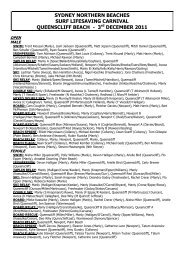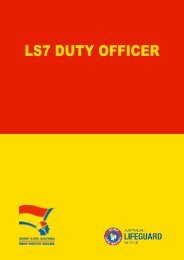
Critical Incident Debrief Flow-Chart - Surf Life Saving NSW
Critical Incident Debrief Flow-Chart - Surf Life Saving NSW
Critical Incident Debrief Flow-Chart - Surf Life Saving NSW

You also want an ePaper? Increase the reach of your titles
YUMPU automatically turns print PDFs into web optimized ePapers that Google loves.
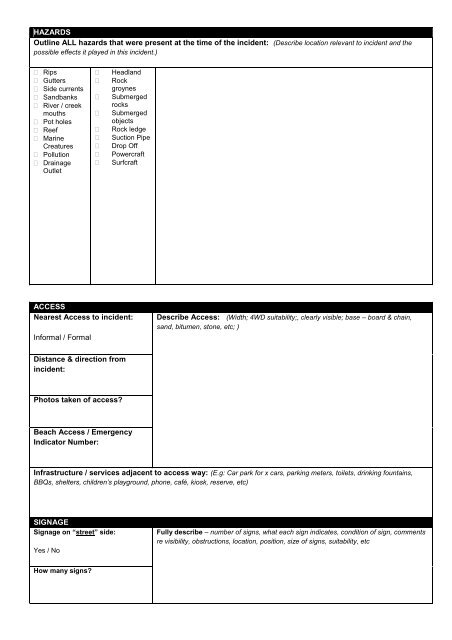
HAZARDS<br />
Outline ALL hazards that were present at the time of the incident: (Describe location relevant to incident and the<br />
possible effects it played in this incident.)<br />
Rips<br />
Gutters<br />
Side currents<br />
Sandbanks<br />
River / creek<br />
mouths<br />
Pot holes<br />
Reef<br />
Marine<br />
Creatures<br />
Pollution<br />
Drainage<br />
Outlet<br />
<br />
<br />
<br />
<br />
<br />
<br />
<br />
<br />
<br />
Headland<br />
Rock<br />
groynes<br />
Submerged<br />
rocks<br />
Submerged<br />
objects<br />
Rock ledge<br />
Suction Pipe<br />
Drop Off<br />
Powercraft<br />
<strong>Surf</strong>craft<br />
ACCESS<br />
Nearest Access to incident:<br />
Informal / Formal<br />
Describe Access: (Width; 4WD suitability;, clearly visible; base – board & chain,<br />
sand, bitumen, stone, etc; )<br />
Distance & direction from<br />
incident:<br />
Photos taken of access?<br />
Beach Access / Emergency<br />
Indicator Number:<br />
Infrastructure / services adjacent to access way: (E.g: Car park for x cars, parking meters, toilets, drinking fountains,<br />
BBQs, shelters, children’s playground, phone, café, kiosk, reserve, etc)<br />
SIGNAGE<br />
Signage on “street” side:<br />
Yes / No<br />
Fully describe – number of signs, what each sign indicates, condition of sign, comments<br />
re visibility, obstructions, location, position, size of signs, suitability, etc<br />
How many signs?