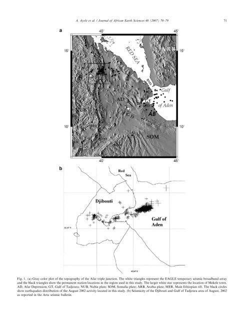
A. Ayele et al. / Journal of African Earth Sciences 48 (2007) 70–79 71 Fig. 1. (a) Gray color plot of the topography of the <strong>Afar</strong> triple junction. <strong>The</strong> white triangles represent the EAGLE temporary seismic broadband array and the black triangles show the permanent station locations <strong>in</strong> the region used <strong>in</strong> this study. <strong>The</strong> larger white star represents the location of Mekele town. AD, <strong>Afar</strong> Depression; GT, Gulf of Tadjoura; NUB, Nubia plate; SOM, Somalia plate; ARB, Arabia plate; MER, Ma<strong>in</strong> Ethiopian rift. <strong>The</strong> black circles show <strong>earthquake</strong>s distribution of the <strong>August</strong> <strong>2002</strong> activity located <strong>in</strong> this study. (b) Seismicity of the Djibouti and Gulf of Tadjoura area of <strong>August</strong>, <strong>2002</strong> as reported <strong>in</strong> the Arta seismic bullet<strong>in</strong>.
72 A. Ayele et al. / Journal of African Earth Sciences 48 (2007) 70–79 of the plume rema<strong>in</strong>s controversial. This propagation of the Red Sea and Gulf of Aden rifts <strong>in</strong>to <strong>Afar</strong> is <strong>in</strong> good agreement with the hypothesis that rift<strong>in</strong>g occurr<strong>in</strong>g close to the boundary between cont<strong>in</strong>ental and oceanic crust preferentially forms on cont<strong>in</strong>ental crust because of its rheological weakness (V<strong>in</strong>k et al., 1984; Müller et al., 2001). <strong>The</strong> <strong>in</strong>teraction of three oblique rifts <strong>in</strong> a plume-affected lithosphere has resulted <strong>in</strong> complex tectonics <strong>in</strong> <strong>Afar</strong>, mak<strong>in</strong>g deformation so distributed that rigid plate k<strong>in</strong>ematics may not currently apply <strong>in</strong> the <strong>in</strong>terior of <strong>Afar</strong>. <strong>The</strong> Red Sea and Gulf of Aden rifts have penetrated <strong>in</strong>to <strong>Afar</strong> where they are now actively open<strong>in</strong>g and propagat<strong>in</strong>g through the development of a series of disconnected rift segments (e.g. Barberi et al., 1972; Manighetti et al., 1998). At a smaller scale, deformation <strong>in</strong> <strong>Afar</strong> seems to have <strong>in</strong>volved the rotation of at least two microplates (Danakil and Ali Sabieh blocks) sandwiched between the three major plates (Chu and Gordon, 1998; Eagles et al., <strong>2002</strong>). From plate reconstructions, the Danakil microplate is <strong>in</strong>ferred to have been part of Nubia at ca. 11 Ma, and s<strong>in</strong>ce then to have rotated counter-clockwise about a pole at 19°N and 42°E (Chu and Gordon, 1998; Eagles et al., <strong>2002</strong>). This model implies oblique-slip to strike-slip motion along the Danakil microplate’s boundary with the Nubia plate and all along the Tendaho-Gobaad discont<strong>in</strong>uity <strong>in</strong> the <strong>Afar</strong> Depression. From radar <strong>in</strong>terferometeric measurement of ground surface displacement (Amelung et al., 2000), significant deformation of about 12 cm subsidence is observed <strong>in</strong> Erta Ale, one of the active volcanoes <strong>in</strong> Ethiopia. <strong>The</strong>se processes are postulated to result from a comb<strong>in</strong>ation of magma withdrawal from a large reservoir and normal fault<strong>in</strong>g. This was the only identifiable deformation event dur<strong>in</strong>g the period June, 1993 to October, 1997 <strong>in</strong> the 80 km long Erta Ale volcanic range, <strong>in</strong>dicat<strong>in</strong>g considerable <strong>in</strong>activity elsewhere <strong>in</strong> the range (Amelung et al., 2000). West of Erta Ale at the plateau marg<strong>in</strong>, there were two periods of <strong>earthquake</strong> activity <strong>in</strong> <strong>August</strong>, <strong>2002</strong> and October, 2004. Start<strong>in</strong>g on <strong>August</strong> 7, <strong>2002</strong>, the Mekele area was shaken by a series of <strong>earthquake</strong>s that occurred near the western marg<strong>in</strong> of the Danakil microplate. <strong>The</strong> activity cont<strong>in</strong>ued until the end of the month and the larger <strong>earthquake</strong>s were widely felt <strong>in</strong> several towns <strong>in</strong> <strong>north</strong>ern Ethiopia (Beyeda, Jane-Amora, Adigrat, Woldia) and Asmara <strong>in</strong> Eritrea, caus<strong>in</strong>g panic <strong>in</strong> particular <strong>in</strong> Mekele town. <strong>The</strong> magnitude of the ma<strong>in</strong> shock is estimated to be 5.6 M w from our study. <strong>The</strong> objective of this paper is to study the <strong>August</strong> <strong>2002</strong> events, which formed the more significant of the two <strong>earthquake</strong> <strong>sequence</strong>s mentioned above, and to <strong>in</strong>terpret the results so as to shed light on the neotectonics of the Danakil microplate. 2. Data and methods <strong>The</strong> <strong>earthquake</strong> <strong>sequence</strong> considered <strong>in</strong> this study was captured by the temporary Ethiopia <strong>Afar</strong> Geoscientific Lithospheric Experiment (EAGLE) phase I broadband network and other permanent seismic stations <strong>in</strong> Ethiopia, Djibouti and Eritrea (Fig. 1a). Most of the seismic stations used <strong>in</strong> the location lie to the south while the two Eritrean stations to the <strong>north</strong> are the nearest to the epicentral region (Fig. 1a). Earthquake locations and relocations are made us<strong>in</strong>g the Hypo<strong>in</strong>verse 2000 (Kle<strong>in</strong>, <strong>2002</strong>) and hypoDD (Waldhauser and Ellsworth, 2000) programs, respectively. A well-constra<strong>in</strong>ed 1-d velocity model (Daly et al., 2004) us<strong>in</strong>g the EAGLE controlled source experiment is used for locat<strong>in</strong>g <strong>earthquake</strong>s. To estimate the <strong>earthquake</strong> source parameters, we modeled the three component displacement waveforms from two or more stations, beg<strong>in</strong>n<strong>in</strong>g with the first P-wave arrival and cont<strong>in</strong>u<strong>in</strong>g through the surface wave tra<strong>in</strong>. Align<strong>in</strong>g at the first P-arrival and bandpass filter<strong>in</strong>g <strong>in</strong> the range of 20–65 s both the observed and synthetic seismograms help to reduce our solution dependence on source location, orig<strong>in</strong> time, and the assumed Earth model. In this bandwidth, almost all the data from the local stations have good signal-to-noise ratio both for the body and surface waves (Figs. 3a–c). Us<strong>in</strong>g complete waveforms from stations located at various azimuths and distances from the source (Fig. 1a) enables a robust estimate of source parameters. We made a time doma<strong>in</strong> l<strong>in</strong>ear <strong>in</strong>version with a least squares approach (Langston, 1981; Ammon et al., 1998). Green’s functions used <strong>in</strong> the <strong>in</strong>version were calculated us<strong>in</strong>g the reflectionmatrix method (Kennett, 1983) as implemented by Randall (1994). We used the same 1-d crustal structure model implemented for <strong>earthquake</strong> locations to generate the Green’s functions. <strong>The</strong> local magnitude, M L , for each of the <strong>earthquake</strong>s <strong>in</strong> the <strong>sequence</strong> is estimated us<strong>in</strong>g the relation presented by Langston et al. (1998). <strong>The</strong> b-value is estimated for the <strong>earthquake</strong>s <strong>in</strong> the Mekele area, <strong>in</strong> the neighborhood of the black rectangle displayed <strong>in</strong> Fig. 1a us<strong>in</strong>g the maximum likelihood approach (Aki, 1965) and least squares to give an idea of the stress status of the seismogenic zone (Scholz, 1968). <strong>The</strong> b-value estimate by Hofstetter and Beyth (2003) for the area is 1.05 but calculated from only seven <strong>earthquake</strong>s with narrow spread <strong>in</strong> magnitude. 3. Results and <strong>in</strong>terpretation Earthquake locations, moment tensor <strong>in</strong>versions and b- value estimates are made for the <strong>August</strong>, <strong>2002</strong> <strong>earthquake</strong> <strong>sequence</strong> <strong>in</strong> <strong>north</strong> <strong>Afar</strong>. 3.1. Earthquake locations From the <strong>August</strong> <strong>2002</strong> seismicity considered <strong>in</strong> this study, 75 <strong>earthquake</strong>s are associated with the plateau marg<strong>in</strong> of the rift east of Mekele and the rema<strong>in</strong><strong>in</strong>g 57 events are distributed <strong>in</strong> other active rift segments of the <strong>Afar</strong> region, mostly <strong>in</strong> the Gulf of Tadjoura (Fig. 1a). Because of the lack of data from Djibouti and Yemen, the Gulf of Tadjoura events are not well-constra<strong>in</strong>ed by our location but the Arta array bullet<strong>in</strong> for that month shows a clear