The Hudson Bay Lithospheric Experiment - University of Bristol
The Hudson Bay Lithospheric Experiment - University of Bristol
The Hudson Bay Lithospheric Experiment - University of Bristol

You also want an ePaper? Increase the reach of your titles
YUMPU automatically turns print PDFs into web optimized ePapers that Google loves.
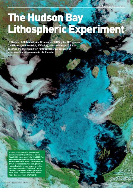
BASTOW ET AL.: HUBLE<strong>The</strong> <strong>Hudson</strong> <strong>Bay</strong><strong>Lithospheric</strong> <strong>Experiment</strong>I D Bastow, J-M Kendall, A M Brisbourne, D B Snyder, D Thompson,D Hawthorn, G R Helffrich, J Wookey, A Horleston and D Eatondescribe the motivation for – and successful operation <strong>of</strong> –a remote seismic survey in Arctic Canada.1: Fields <strong>of</strong> sea ice melt in northeasternCanada’s <strong>Hudson</strong> <strong>Bay</strong> in this false-colourAqua MODIS image acquired in July 2003. <strong>The</strong>ice in this image appears bright turquoise,while liquid water is black. Land is green andbrown, and clouds are white and light blue.<strong>Hudson</strong> <strong>Bay</strong> is the second largest bay in theworld, encompassing 1 230 000 km 2 , but isrelatively shallow with an average depth <strong>of</strong>about 100 m. (Jacques Descloitres, MODISRapid Response Team, NASA/GSFC)A&G 6.21
BASTOW ET AL.: HUBLEGeologists can usually interpret the rocksthey encounter on Earth in the light <strong>of</strong>tectonic and volcanic processes presentlyoperating at the plate boundaries. Thisapproach works well for relatively young rocks(Phanerozoic: younger than 550 million yearsold), but for the older rocks that formed duringPrecambrian times (more than 550 million yearsold), the “plate tectonic” assumption must ultimatelybreak down. Processes operating on theyounger, hotter Earth would have been quite differentto those we see today. Gathering detailedevidence preserved deep within the plates in theancient cores <strong>of</strong> the continents (“shields”), isthus essential to our understanding <strong>of</strong> the earlyEarth. This can be achieved using data fromdense seismograph networks, but building andmaintaining them in remote areas is both logisticallyand financially challenging; innovativestation and equipment designs are required todeliver the success enjoyed in gentler climes.<strong>The</strong> <strong>Hudson</strong> <strong>Bay</strong> <strong>Lithospheric</strong> <strong>Experiment</strong>(HuBLE), a recent UK–Canadian venture inArctic Canada, has addressed these issues inorder to place fundamental constraints on Earthstructure beneath the Canadian Shield. <strong>The</strong>resulting data provide a tantalizing hint as to theprocesses that operated on the youthful Earth.Beneath the shieldsOver the past 25 years seismologists have studiedthe internal structure <strong>of</strong> the Earth beneathregions <strong>of</strong> tectonic interest using data from distantearthquakes recorded by dense networks <strong>of</strong>seismograph stations. <strong>The</strong>se experiments haveyielded high-resolution images <strong>of</strong> crust andmantle structure that have advanced considerablyour understanding <strong>of</strong> the internal structureand dynamics <strong>of</strong> the Earth. However, asbudgets tighten and the target regions for suchendeavours become increasingly remote, maintainingthis level <strong>of</strong> success becomes ever morechallenging. Shields, the diamond and mineralrichancient cores <strong>of</strong> the continents that haveremained stable for billions <strong>of</strong> years since theirformation, can be particularly awkward customersin this regard. <strong>The</strong> motivation to understandtheir geology is high but our database <strong>of</strong>constraints remains relatively small. <strong>The</strong>re isan issue <strong>of</strong> interpretation in shield regions too:most relatively young (
BASTOW ET AL.: HUBLEalso financially and logistically prohibitive, soinnovative station designs are required.HuBLEbatteriespower regulatorseismometerrecording unitWith the goal <strong>of</strong> constraining better the reasonfor the existence <strong>of</strong> <strong>Hudson</strong> <strong>Bay</strong>, and the Precambrianprocesses that shaped the Canadianshield, the <strong>Hudson</strong> <strong>Bay</strong> <strong>Lithospheric</strong> <strong>Experiment</strong>(HuBLE) was deployed in the summer <strong>of</strong> 2007by personnel from the <strong>University</strong> <strong>of</strong> <strong>Bristol</strong>, incollaboration with the Geological Survey <strong>of</strong>Canada. Nunavut, the homeland <strong>of</strong> the Inuit,is the most sparsely populated region <strong>of</strong>Canada; centres <strong>of</strong> population andinfrastructure are few and farbetween. Wherever possible,seismograph stations weredeployed in safe compounds,such as airports and weatherstations with mains powersupply, and in small communitysettlements in Nunavut.Elsewhere, vast tracts <strong>of</strong> wildernessmeant that remote, independentlypowered recording sites had tobe designed within the financial limitations <strong>of</strong>the project. Transport to these locations was bychartered light aircraft with large tundra tyresto permit landing and take-<strong>of</strong>f from relativelyflat and well-drained glacial deposits (figure 4).Figure 4 shows a completed HuBLE seismographstation in northern <strong>Hudson</strong> <strong>Bay</strong>. Eachsite was equipped with a Güralp CMG-3TDbroadband seismometer, recording at 40 samplesper second. Güralp DCM data recorderswere used at the stations, which were poweredby up to six solar panels (providing 100–140 Wsatellite modem4: HuBLE-UK remote station construction. 20–40 W solar panels on a steel frame recharge3 100 Ah batteries that power the seismometer and recording equipment. <strong>The</strong> GPS antennaprovides continuous accurate timing information. Remote communication with the stations isvia an Iridium satellite modem antenna that was scheduled to operate twice weekly. All fieldequipment is provided by NERC’s seismic equipment pool, SEIS-UK (box 1).‘‘ <strong>The</strong>remoteness <strong>of</strong> theHuBLE network wasa hindrance during thefield campaign, buta blessing for thedata analysispower) and three 100 Ah deep-cycle batteries.Each remote site was equipped with an Iridiumsatellite modem that provided state-<strong>of</strong>-healthdata from the stations. Data retrieved using themodems included: station up-time; digitizer,seismometer, and recorder baud rates; externalhard disk usage; seismometer levelling information;GPS timing information; power supply.Using modems over the Iridium networkprovides pole-to-pole global coverage <strong>of</strong> bothshort message and short data burst services.For the CMG-DCM, this allowed the UK basestation to pull <strong>of</strong>f weekly reports <strong>of</strong> thestate <strong>of</strong> health <strong>of</strong> the remote system.Where problems were diagnosed,’’GPS antennasolar panelslow-latency two-way communicationfor reconfiguration<strong>of</strong> the remote systems wasalso used via simple terminalinteraction. All seismicstation equipment are maintainedby SEIS-UK (see box1), part <strong>of</strong> the Natural EnvironmentResearch Council’s geophysicalequipment facility in Leicester.Where major physical damage to a station(such as cable damage from polar bear attacks)was deduced from the satellite modem data, theservicing team was able to focus its visits onthe problem stations, leaving those operatingsmoothly for the following year. This strategysaved thousands <strong>of</strong> pounds in plane chartertime. Arguably the greatest benefit <strong>of</strong> the satellitemodem system, however, was the abilityto carry out instrument configuration repairsremotely from the UK. In the summers <strong>of</strong> 2008and 2009, for example, two stations suffered1: SEIS-UKSEIS-UK – the UK’s Seismic EquipmentFacility based within the <strong>University</strong> <strong>of</strong>Leicester – is one <strong>of</strong> three nodes that makeup the NERC Geophysical EquipmentFacility (GEF). It maintains a large anddiverse pool <strong>of</strong> seismic instrumentationand associated field equipment for onshorerecording <strong>of</strong> both earthquakes andcontrolled seismic sources. <strong>The</strong> equipmentis available for use free-<strong>of</strong>-charge toUK-based academics via a single loanapplication and subsequent peer review.To date the majority <strong>of</strong> SEIS-UK projectshave been basedoutside the UK, fromEthiopia to <strong>Hudson</strong><strong>Bay</strong>, and haveinvolved substantialcollaboration withnon-UK academics and institutions. <strong>The</strong>facility supports around 12 field projectsa year, providing expertise and trainingin the use <strong>of</strong> the field equipment andassociated data management systems.A processing system for continuousseismic data is fully supported, includingearthquake detection and location.In-house servers with more than 20 Tb <strong>of</strong>storage provide a rapid and convenientroute to data processing while removingthe need for users to maintain expensiveand time-consuming computing facilities<strong>of</strong> their own. SEIS-UK also manages thearchiving <strong>of</strong> data at the IRIS DMC fromwhere data become publicly available.winter power-outages from which they could notrecover. <strong>The</strong> seismometer and recording module(figure 4) had defaulted to different communicationbaud rates but, by logging into the stationremotely, the necessary corrections to therecording parameters were made. An additionalbenefit <strong>of</strong> the satellite modem systems was theability to unlock and reorient seismometers thathad moved significantly or ceased to operate –common in spring-time when shallow permafrostin the Arctic can begin to melt. Carryingout station repairs in this way, as opposed towaiting until the summer service runs, improveddata yield from the experiment by ~20%. <strong>The</strong>cost <strong>of</strong> running the modems, the equivalent <strong>of</strong>two or three transatlantic flights per year, wasexcellent value for money.Scientific insights from CanadaWhile the remoteness <strong>of</strong> the HuBLE networkwas a hindrance during the field campaign, itwas a blessing for the data analysis. <strong>The</strong> quality<strong>of</strong> seismic signals from seismic stations installedso close to basement rock, far away fromA&G 6.23
BASTOW ET AL.: HUBLE2: Receiver functions(a)S waveP wavePpPs PsPs Pp Ps+PpSsthree-componentseismic stationMohoReceiver functions are time series, computedfrom three-component seismograms, whichshow the relative response <strong>of</strong> Earth structurenear the receiver (Phinney 1964). <strong>The</strong>waveform is a composite <strong>of</strong> P-to-S convertedwaves that reverberate in the structurebeneath the seismometer (figure 5a). <strong>The</strong>ythus carry valuable information aboutvelocity discontinuities in the Earth suchas the crust–mantle boundary (the Moho).A radial receiver function (figure 5b) candirect P wave(b)PsPpPsPpSs+PsPs5: Receiver function analysis <strong>of</strong> velocity structure beneath a seismic station. (After Ammon 1991)PsSsbe computed by deconvolving the verticalcomponent seismogram from radial (SV)component (and the same procedure for thetangential component, SH). In the frequencydomain this can be written:H(w) = R(w) / Z(w) (1)where w is the angular frequency 2f.Z(w) and R(w) are the Fourier transforms<strong>of</strong> the vertical and radial seismograms.H(w) is the Fourier transform <strong>of</strong> the receiverfunction.3: Shear-wave splittingSeismic anisotropy – the directionaldependence <strong>of</strong> seismic wavespeed – canresult from the alignment <strong>of</strong> minerals suchas olivine in the crust and mantle, andthe preferential alignment <strong>of</strong> fluid. In ananisotropic medium, a shear-wave willsplit into two orthogonal components,one travelling faster than the other. Thisphenomenon is known as shear-wavesplitting. Analysis <strong>of</strong> shear-wave splittingis common amongst seismologists (e.g.Silver and Chan 1991) because the splittingparameters (the orientation <strong>of</strong> the fastshear wave) and t (the lag-time betweenthe fast and slow shear wave, see figure6) can be related readily, for example, tomantle flow (e.g. Fouch et al. 2000), thepreferential alignment <strong>of</strong> magma (e.g.Blackman and Kendall 1997, Bastow et al.2010), pre-existing fossil anisotropy frozendeep in plates (e.g. Helffrich 1995, Bastowet al. 2007), or any combination there<strong>of</strong>.sources <strong>of</strong> cultural noise, has been extremelyhigh. This, in turn, has enabled us to place fundamentalnew constraints on the deep structure<strong>of</strong> the Earth beneath this region.A receiver function (see box 2) study <strong>of</strong> crustalstructure (Thompson et al. 2010) providedfresh insight into the processes that shaped andformed Earth’s oldest crust. Formation <strong>of</strong> theCanadian Shield is likely to have evolved fromprocesses characterized by a hot ductile regimeduring the Paleoarchean, to those more closelyresembling modern day-style plate tectonicsby the Paleoproterozoic. An SKS shear-wavesplitting (see box 3) study <strong>of</strong> seismic anisotropy(Bastow et al. 2011) provided further evidencein support <strong>of</strong> this view, with strong anisotropicfabrics preserved deep in the North Americanplate. <strong>The</strong>se recorded the 1.8 billion-year-oldmountain-building event called the Trans-<strong>Hudson</strong> Orogen that geologists have speculatedwas <strong>of</strong> similar scale and nature to the currentTibetan–Karakoram–Himalayan orogen <strong>of</strong>Asia (e.g. H<strong>of</strong>fman 1988, St-Onge et al. 2006).As well as shedding light on the ancient lithosphericprocesses that shaped northern Canada,our seismic data are capable <strong>of</strong> addressing thegeodynamic puzzle <strong>of</strong> why <strong>Hudson</strong> <strong>Bay</strong> (thelargest intracratonic basin in the world) existsat all. One hypothesis for the existence <strong>of</strong> the<strong>Bay</strong> is that a down-welling in the underlyingmantle is dragging the <strong>Hudson</strong> <strong>Bay</strong> basin downbelow sea level. Using receiver function (box 2)analysis to measure the thickness <strong>of</strong> the mantletransition zone, however, we have shown thatthere is no evidence for a thermal anomaly –hot or cold – beneath the region. This impliesthat whatever the reason for the existence <strong>of</strong> the<strong>Bay</strong>, it is almost certainly confined to the uppermantle (Thompson et al. 2011 in press). Ouranalysis <strong>of</strong> shallow crustal structure beneaththe region also indicates that the <strong>Hudson</strong> <strong>Bay</strong>basin may owe its existence, at least in part, tocrustal thinning (Pawlak et al. 2010).<strong>The</strong> innovative seismograph station designsemployed during the HuBLE experiment showclearly that successful seismic experiments canbe conducted in even the harshest and remotest<strong>of</strong> environments. <strong>The</strong> challenge now is thus toexplore seismically Earth’s more remote regions,as well as the sunnier climes where our database<strong>of</strong> constraints is increasingly well established. ●I D Bastow (ian.bastow@bristol.ac.uk), J-MKendall, G R Helffrich, D A Thompson, J Wookey,A Horleston, School <strong>of</strong> Earth Sciences, <strong>University</strong><strong>of</strong> <strong>Bristol</strong>, UK; A M Brisbourne, D Hawthorn,SEIS-UK, Geology Department, <strong>University</strong><strong>of</strong> Leicester, Leicester; D Eaton, Department<strong>of</strong> Geoscience, <strong>University</strong> <strong>of</strong> Calgary, Alberta,Canada; D B Snyder, Geological Survey <strong>of</strong>Canada, Ottawa, Ontario, Canada.Acknowledgments. HuBLE-UK was supportedby NERC grant NE/F007337/1, with logisticalsupport from the GSC, CNGO, SEIS-UK and FirstNations communities <strong>of</strong> Nunavut. J Beauchesneand J Kendall provided invaluable assistance in thefield. IB is funded by the Leverhulme Trust.ReferencesAmmon CBull. Seis. Soc. Am. 81(6)Bastow I et al.Geophys. Res. Lett. 34(5)Bastow I et al.Geology 39(1)6: Shear-wave splitting in an anisotropicmedia. When the two pulses reach aseismometer, seismologists can measurethe differential time and polarization <strong>of</strong> theenergy. <strong>The</strong>se parameters can then be usedto characterize the anisotropy.Bastow I et al.Geochem. Geophys. Geosyst.Q0AB10Blackman D and J KendallPhil. Trans. R. Soc.Lond. 355Cawood P et al. GSA Today 16(7)Eaton D and F DarbyshireTectonophysicsEaton D J et al. EOS Transactions 86Fouch M A et al. J. Geophys Res. 105Furnes H et al. Science 315(5819)Hamilton WGSA Today 13(11)Helffrich G J. Geophys. Res. 100(B9)H<strong>of</strong>fman PAnnual Review <strong>of</strong> Earth and PlanetarySciences 16Hopkins M et al. Nature 456Pawlak A et al. Geophys. J. Int. 184Phinney R A J. Geophys. Res. 69Silver P and G Chan J. Geophys. Res. 96St-Onge M et al. Tectonics 25 (4)Stern R Geology 33(7)Thompson D A Earth Planet. Sci. Lett. 297Thompson D A et al.Earth Planet. Sci. Lett. 3126.24 A&G