

Draft Plan of Management for the Dargan Creek Reserve - Land
Draft Plan of Management for the Dargan Creek Reserve - Land
Draft Plan of Management for the Dargan Creek Reserve - Land

Create successful ePaper yourself
Turn your PDF publications into a flip-book with our unique Google optimized e-Paper software.
DARGAN CREEK RESERVE<br />
<strong>Draft</strong> <strong>Plan</strong> <strong>of</strong> <strong>Management</strong><br />
Prepared <strong>for</strong><br />
<strong>Dargan</strong> <strong>Creek</strong> <strong>Reserve</strong> Trust, Crown <strong>Land</strong>s Division, NSW Department <strong>of</strong> Primary Industries<br />
20 July 2011<br />
Crown <strong>Land</strong>s Division<br />
Department <strong>of</strong> Primary Industries
D a r g a n C r e e k R e s e r v e P l a n o f M a n a g e m e n t<br />
DOCUMENT TRACKING<br />
ITEM<br />
Project Name<br />
Project Number<br />
File location<br />
Prepared by<br />
Approved by<br />
Status<br />
DETAIL<br />
<strong>Dargan</strong> <strong>Creek</strong> <strong>Plan</strong> <strong>of</strong> <strong>Management</strong><br />
10SUTPLA-0025<br />
G:\Synergy\Projects\10SUTPLA\10SUTPLA-0025 <strong>Dargan</strong> <strong>Creek</strong> <strong>Reserve</strong> <strong>Plan</strong> <strong>of</strong><br />
<strong>Management</strong>\Report\<strong>Draft</strong> Reports<br />
Melissa Head, Steve Dimitriadis, Karen Spicer<br />
Mark Adams<br />
DRAFT<br />
Version Number 6<br />
Last saved on 20 July 2011<br />
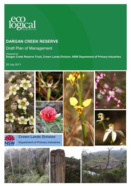
Cover photo<br />
Various flora, <strong>Dargan</strong> <strong>Creek</strong> <strong>Reserve</strong>. Photos by Martin Sullivan or Melissa Head <strong>of</strong> Eco<br />
Logical Australia<br />
This report should be cited as „Eco Logical Australia 2011. <strong>Dargan</strong> <strong>Creek</strong> <strong>Reserve</strong> <strong>Plan</strong> <strong>of</strong><br />
<strong>Management</strong>. Prepared <strong>for</strong> Crown <strong>Land</strong>s Division, NSW Department <strong>of</strong> Primary Industries‟.<br />
ACKNOWLEDGEMENTS<br />
This document has been prepared by Eco Logical Australia Pty Ltd with support from <strong>the</strong> Crown <strong>Land</strong>s<br />
Division, NSW Department <strong>of</strong> Primary Industries.<br />
Disclaimer<br />
This document may only be used <strong>for</strong> <strong>the</strong> purpose <strong>for</strong> which it was commissioned and in accordance with <strong>the</strong> contract between<br />
Eco Logical Australia Pty Ltd and NSW Department <strong>of</strong> Primary Industries (Crown <strong>Land</strong>s Division). The scope <strong>of</strong> services was<br />
defined in consultation with NSW Department <strong>of</strong> Primary Industries (Crown <strong>Land</strong>s Division), by time and budgetary constraints<br />
imposed by <strong>the</strong> client, and <strong>the</strong> availability <strong>of</strong> reports and o<strong>the</strong>r data on <strong>the</strong> subject area. Changes to available in<strong>for</strong>mation,<br />
legislation and schedules are made on an ongoing basis and readers should obtain up to date in<strong>for</strong>mation.<br />
Eco Logical Australia Pty Ltd accepts no liability or responsibility whatsoever <strong>for</strong> or in respect <strong>of</strong> any use <strong>of</strong> or reliance upon this<br />
report and its supporting material by any third party. In<strong>for</strong>mation provided is not intended to be a substitute <strong>for</strong> site specific<br />
assessment or legal advice in relation to any matter. Unauthorised use <strong>of</strong> this report in any <strong>for</strong>m is prohibited.<br />
© E C O L O G I C A L A U S T R A L I A P T Y L T D<br />
i
D a r g a n C r e e k R e s e r v e P l a n o f M a n a g e m e n t<br />
Contents<br />
Executive Summary ................................................................................................................................ 1<br />
1 Introduction ................................................................................................................................. 3<br />
1.1 <strong>Land</strong> to which <strong>the</strong> <strong>Plan</strong> <strong>of</strong> <strong>Management</strong> Applies .......................................................................... 3<br />
1.2 Vision and Objectives ................................................................................................................... 6<br />
1.3 Managing Crown <strong>Land</strong>s ................................................................................................................ 8<br />
1.4 Stakeholder Consultation ........................................................................................................... 10<br />
2 <strong>Reserve</strong> Assessment ............................................................................................................... 11<br />
2.1 <strong>Reserve</strong> Location and Description ............................................................................................. 11<br />
2.2 Background and History ............................................................................................................. 11<br />
2.3 Surrounding <strong>Land</strong> Use and Regional Context ............................................................................ 18<br />
2.4 <strong>Land</strong><strong>for</strong>m, Geology and Soils ..................................................................................................... 18<br />
2.5 Climate ........................................................................................................................................ 23<br />
2.6 Hydrology .................................................................................................................................... 23<br />
2.7 Water Quality .............................................................................................................................. 23<br />
2.8 Vegetation................................................................................................................................... 24<br />
2.9 Fauna Habitat ............................................................................................................................. 32<br />
2.10 Cultural Heritage ......................................................................................................................... 35<br />
2.11 Fire .............................................................................................................................................. 37<br />
3 Issues, Objectives and Actions............................................................................................... 39<br />
3.1 Formation <strong>of</strong> a community trust Board ....................................................................................... 39<br />
3.2 <strong>Reserve</strong> Access .......................................................................................................................... 40<br />
3.3 Public Recreation ....................................................................................................................... 47<br />
3.4 Climbing and Canyoning ............................................................................................................ 48<br />
3.5 Commercial Recreation .............................................................................................................. 49<br />
3.6 Conservation <strong>of</strong> Natural Values .................................................................................................. 51<br />
3.7 Upland Swamps ......................................................................................................................... 52<br />
3.8 Threatened Flora ........................................................................................................................ 54<br />
3.9 Weeds ......................................................................................................................................... 54<br />
3.10 Threatened Fauna ...................................................................................................................... 56<br />
3.11 Vertebrate Pests ......................................................................................................................... 57<br />
3.12 Fire .............................................................................................................................................. 58<br />
3.13 Cultural Heritage ......................................................................................................................... 59<br />
3.14 Additional <strong>Land</strong> ........................................................................................................................... 60<br />
© E C O L O G I C A L A U S T R A L I A P T Y L T D<br />
ii
D a r g a n C r e e k R e s e r v e P l a n o f M a n a g e m e n t<br />
3.15 Summary <strong>of</strong> <strong>Management</strong> objectives ......................................................................................... 61<br />
4 Implementation ......................................................................................................................... 63<br />
4.1 Potential Opportunities ............................................................................................................... 63<br />
4.2 Implementation Action <strong>Plan</strong> ........................................................................................................ 63<br />
5 Monitoring and Review ............................................................................................................ 70<br />
References ............................................................................................................................................. 71<br />
Appendix A: Relevant Legislation ....................................................................................................... 73<br />
Appendix B: Stakeholder Consultation .............................................................................................. 79<br />
Stakeholder Consultation ........................................................................................................................ 79<br />
<strong>Reserve</strong> Values ....................................................................................................................................... 79<br />
Key Issues ............................................................................................................................................... 79<br />
Appendix C: Vegetation Community Descriptions ............................................................................ 82<br />
Appendix D: <strong>Management</strong> Actions <strong>for</strong> Threatened Flora .................................................................. 86<br />
Appendix E: <strong>Management</strong> Actions <strong>for</strong> Threatened Fauna ................................................................ 92<br />
© E C O L O G I C A L A U S T R A L I A P T Y L T D<br />
iii
D a r g a n C r e e k R e s e r v e P l a n o f M a n a g e m e n t<br />
List <strong>of</strong> Figures<br />
Figure 1: <strong>Dargan</strong> <strong>Creek</strong> <strong>Reserve</strong> Study Area ............................................................................................ 5<br />
Figure 2: The location <strong>of</strong> <strong>Dargan</strong> <strong>Creek</strong> <strong>Reserve</strong> at a regional scale. ....................................................... 7<br />
Figure 3: Drainage map ............................................................................................................................ 14<br />
Figure 4: Surrounding <strong>Land</strong> Tenure ......................................................................................................... 19<br />
Figure 5: Soil <strong>Land</strong>scape Map <strong>for</strong> <strong>Dargan</strong> <strong>Creek</strong> <strong>Reserve</strong> ...................................................................... 20<br />
Figure 6: Vegetation Communities within <strong>Dargan</strong> <strong>Creek</strong> <strong>Reserve</strong> ........................................................... 26<br />
Figure 7: The distribution <strong>of</strong> Endangered Ecological Communities within <strong>Dargan</strong> <strong>Creek</strong> <strong>Reserve</strong>. ........ 27<br />
Figure 8: Access issues at <strong>Dargan</strong> <strong>Creek</strong> <strong>Reserve</strong> showing <strong>the</strong> location <strong>of</strong> existing trails and proposed<br />
day use car park. ...................................................................................................................................... 46<br />
List <strong>of</strong> Tables<br />
Table 1: <strong>Land</strong> parcels within <strong>Dargan</strong> <strong>Creek</strong> <strong>Reserve</strong> covered by this <strong>Plan</strong> <strong>of</strong> <strong>Management</strong> ..................... 4<br />
Table 2: Previous Licence Holders........................................................................................................... 15<br />
Table 3: Issues to be considered in commercial licence agreements between <strong>the</strong> Department and<br />
commercial operators (LPMA 2007)......................................................................................................... 16<br />
Table 4: Threatened flora species listed under <strong>the</strong> TSC Act that occur or are likely to occur with <strong>the</strong><br />
<strong>Reserve</strong> .................................................................................................................................................... 29<br />
Table 5: Key habitat features and species ............................................................................................... 32<br />
Table 6: Threatened fauna species likely to occur within <strong>the</strong> <strong>Reserve</strong> .................................................... 34<br />
Table 7: Introduced Fauna Species ......................................................................................................... 35<br />
Table 8: Noxious weeds known to occur at <strong>the</strong> <strong>Reserve</strong> and <strong>the</strong>ir respective control plan ..................... 56<br />
Table 9: Suggested fire management zones to be identified <strong>for</strong> <strong>Dargan</strong> <strong>Creek</strong> <strong>Reserve</strong> (Adapted from<br />
NPWS 2004) ............................................................................................................................................. 58<br />
Table 10: Summary <strong>of</strong> <strong>Management</strong> Objectives ...................................................................................... 61<br />
Table 11: Implementation Action <strong>Plan</strong> .................................................................................................... 63<br />
Table 12: Summary <strong>of</strong> Stakeholder Issues .............................................................................................. 81<br />
© E C O L O G I C A L A U S T R A L I A P T Y L T D<br />
iv
D a r g a n C r e e k R e s e r v e P l a n o f M a n a g e m e n t<br />
List <strong>of</strong> Plates<br />
Plate 1: <strong>Dargan</strong> <strong>Creek</strong> <strong>Reserve</strong> and <strong>the</strong> upper dam .................................................................................. 6<br />
Plate 2: Heathland protected within <strong>Dargan</strong> <strong>Creek</strong> <strong>Reserve</strong> ................................................................... 10<br />
Plate 3: Gate installed to prevent people walking across <strong>the</strong> dam wall <strong>of</strong> <strong>the</strong> lower dam. ...................... 13<br />
Plate 4: The climbing wall located at <strong>the</strong> end <strong>of</strong> <strong>the</strong> easement below <strong>the</strong> lower dam .............................. 17<br />
Plate 5: Steep cliffs at <strong>the</strong> lower dam ....................................................................................................... 21<br />
Plate 6: Heathland north <strong>of</strong> <strong>the</strong> top dam with <strong>the</strong> land sloping down to <strong>the</strong> west towards <strong>Dargan</strong> <strong>Creek</strong>21<br />
Plate 7: Same location as Plate 5 facing east along <strong>the</strong> electricity easement ......................................... 22<br />
Plate 8: Woodland located west <strong>of</strong> <strong>the</strong> railway easement ........................................................................ 22<br />
Plate 9: Weeds including Pinus radiata, Hypericum per<strong>for</strong>atum and Hypochaeris radicata along Chifley<br />
Road on <strong>the</strong> western edge <strong>of</strong> <strong>the</strong> <strong>Reserve</strong>. .............................................................................................. 31<br />
Plate 10: The upper dam wall and associated infrastructures requires a cultural heritage assessment<br />
.................................................................................................................................................................. 37<br />
Plate 11: Evidence <strong>of</strong> a recent fire (
D a r g a n C r e e k R e s e r v e P l a n o f M a n a g e m e n t<br />
Abbreviations<br />
ABBREVIATION<br />
DESCRIPTION<br />
CLA Crown <strong>Land</strong>s Act 1989<br />
CTHLT<br />
OEH<br />
DPI<br />
DSC<br />
EEC<br />
ELA<br />
Central Tablelands Heritage <strong>Land</strong>s Trust<br />
Office <strong>of</strong> Environment and Heritage<br />
Department <strong>of</strong> Primary Industries (NSW)<br />
Dams Safety Committee<br />
Endangered Ecological Community<br />
Eco Logical Australia Pty Ltd<br />
EPBC Environment Protection and Biodiversity Conservation Act 1999<br />
HNCMA<br />
HRB<br />
KTP<br />
LGA<br />
LPMA<br />
NPWS<br />
PAS<br />
PoM<br />
RFS<br />
Hawkesbury-Nepean Catchment <strong>Management</strong> Authority<br />
Hazard Reduction Burn<br />
Key Threatening Process<br />
Local Government Area<br />
<strong>Land</strong> and Property <strong>Management</strong> Authority (now known as <strong>the</strong> Crown <strong>Land</strong>s Division <strong>of</strong> <strong>the</strong><br />
NSW Department <strong>of</strong> Primary Industries, in this report „Department‟)<br />
National Parks and Wildlife Service<br />
Priority Action Statement<br />
<strong>Plan</strong> <strong>of</strong> <strong>Management</strong><br />
Rural Fire Service<br />
TSC Threatened Species Conservation Act 1995<br />
UMCC<br />
Upper Macquarie County Council<br />
© E C O L O G I C A L A U S T R A L I A P T Y L T D<br />
vi
D a r g a n C r e e k R e s e r v e P l a n o f M a n a g e m e n t<br />
Executive Summary<br />
<strong>Dargan</strong> <strong>Creek</strong> <strong>Reserve</strong> is located in <strong>the</strong> Central Tablelands <strong>of</strong> New South Wales between <strong>the</strong> towns <strong>of</strong><br />
Clarence and <strong>Dargan</strong>, approximately 15 km east <strong>of</strong> Lithgow. The <strong>Reserve</strong> has an area <strong>of</strong><br />
approximately 591.5 ha and falls within <strong>the</strong> Lithgow City Council Local Government Area (LGA).<br />
The <strong>Reserve</strong> is defined by Bells Line <strong>of</strong> Road / Chifley Road to <strong>the</strong> north, <strong>Dargan</strong> <strong>Creek</strong> to <strong>the</strong> sou<strong>the</strong>astern<br />
boundary and residential areas to <strong>the</strong> northwest. The sou<strong>the</strong>rn section <strong>of</strong> <strong>the</strong> <strong>Reserve</strong> is<br />
contiguous with large areas <strong>of</strong> vegetation including Blue Mountains National Park World Heritage Area<br />
to <strong>the</strong> east.<br />
The <strong>Reserve</strong> is Crown <strong>Land</strong> apart from <strong>the</strong> western railway, which runs through <strong>the</strong> north <strong>of</strong> <strong>the</strong><br />
<strong>Reserve</strong>, with <strong>the</strong> railway corridor and a network <strong>of</strong> easements owned and managed by RailCorp.<br />
There are also two freehold lots within <strong>the</strong> <strong>Reserve</strong>. The current purpose <strong>of</strong> <strong>the</strong> Crown <strong>Land</strong> in <strong>Dargan</strong><br />
<strong>Creek</strong> <strong>Reserve</strong> is <strong>for</strong> recreation and is managed by <strong>the</strong> <strong>Dargan</strong> <strong>Creek</strong> <strong>Reserve</strong> Trust.<br />
This <strong>Plan</strong> <strong>of</strong> <strong>Management</strong> (PoM) has been prepared <strong>for</strong> <strong>the</strong> <strong>Dargan</strong> <strong>Creek</strong> <strong>Reserve</strong> Trust in accordance<br />
with <strong>the</strong> requirements <strong>of</strong> <strong>the</strong> Crown <strong>Land</strong>s Act 1989 (CLA). The <strong>Reserve</strong>s values and threats have<br />
been identified, along with objectives and actions <strong>for</strong> <strong>the</strong> long-term sustainable management <strong>of</strong> <strong>Dargan</strong><br />
<strong>Creek</strong> <strong>Reserve</strong>. The plan has been produced in consultation with community and relevant<br />
stakeholders.<br />
The <strong>Reserve</strong> is comprised <strong>of</strong> largely intact native vegetation with <strong>the</strong> main areas <strong>of</strong> disturbance in <strong>the</strong><br />
north-east associated with two disused concrete dams. Disturbance includes littering, soil erosion and<br />
sedimentation, and vegetation disturbance primarily from visitors to <strong>the</strong> dam and illegal vehicle use<br />
throughout <strong>the</strong> <strong>Reserve</strong>s management access tracks and railway easements.<br />
Key values <strong>of</strong> <strong>the</strong> <strong>Reserve</strong> include:<br />
Recreational value <strong>of</strong> <strong>the</strong> <strong>Reserve</strong> <strong>for</strong> bushwalking, rock climbing and canyoning.<br />
Commercial value <strong>for</strong> operators running rock climbing and canyoning guided tours.<br />
High ecological value due to <strong>the</strong> <strong>Reserve</strong>s large intact size, low levels <strong>of</strong> weed invasion,<br />
proximity to Blue Mountains World Heritage Area, presence <strong>of</strong> several upland swamps<br />
(endangered ecological communities and key habitat <strong>for</strong> a number <strong>of</strong> threatened species),<br />
overall good condition <strong>of</strong> vegetation and varied habitat features.<br />
Recreational opportunities including rock climbing, bushwalking and canyoning, which a<br />
number <strong>of</strong> commercial operators using <strong>the</strong> <strong>Reserve</strong>.<br />
The <strong>Reserve</strong> is threatened by rubbish dumping and environmental degradation, particularly from<br />
vehicular access to <strong>the</strong> dam, which has widened and eroded <strong>the</strong> tracks and spoils <strong>the</strong> visual amenity <strong>of</strong><br />
<strong>the</strong> area and threatens <strong>the</strong> endangered upland swamp communities. Previous attempts to keep<br />
vehicles out <strong>of</strong> <strong>the</strong> <strong>Reserve</strong> have been met with vandalism <strong>of</strong> gates, bollards and locks.<br />
This PoM identifies opportunities <strong>for</strong> <strong>Dargan</strong> <strong>Creek</strong> <strong>Reserve</strong> to be managed in a sustainable way<br />
through <strong>the</strong> following actions:<br />
© E C O L O G I C A L A U S T R A L I A P T Y L T D<br />
1
D a r g a n C r e e k R e s e r v e P l a n o f M a n a g e m e n t<br />
Constructing a day-use car park <strong>of</strong>f Chifley Road using a Crown Road and closing all o<strong>the</strong>r<br />
public vehicular access using locked gates and fencing;<br />
Restricting vehicle access will protect biodiversity, reduce erosion and sedimentation and<br />
protect public safety;<br />
Develop a network <strong>of</strong> <strong>for</strong>mal walking tracks and in<strong>for</strong>mation signage to allow safe enjoyment <strong>of</strong><br />
<strong>the</strong> <strong>Reserve</strong>;<br />
Identify <strong>the</strong> biodiversity and cultural heritage values <strong>of</strong> <strong>the</strong> <strong>Reserve</strong> which will in<strong>for</strong>m<br />
management <strong>of</strong> <strong>the</strong> <strong>Reserve</strong> including management <strong>of</strong> weeds, threatened species, upland<br />
swamps, fire and cultural heritage;<br />
Manage <strong>the</strong> sustainable use <strong>of</strong> <strong>the</strong> <strong>Reserve</strong> <strong>for</strong> recreational and commercial uses<br />
Encourage community involvement in management <strong>of</strong> <strong>the</strong> <strong>Reserve</strong> through landcare and<br />
swampcare, restoration works and <strong>for</strong>ming a community trust once management <strong>of</strong> <strong>the</strong> <strong>Reserve</strong><br />
is stabilised.<br />
© E C O L O G I C A L A U S T R A L I A P T Y L T D<br />
2
D a r g a n C r e e k R e s e r v e P l a n o f M a n a g e m e n t<br />
1 Introduction<br />
This <strong>Plan</strong> <strong>of</strong> <strong>Management</strong> (PoM) has been prepared <strong>for</strong> <strong>the</strong> <strong>Dargan</strong> <strong>Creek</strong> <strong>Reserve</strong> Trust in accordance<br />
with <strong>the</strong> requirements <strong>of</strong> <strong>the</strong> Crown <strong>Land</strong>s Act 1989 (CLA). The PoM identifies objectives and actions<br />
<strong>for</strong> <strong>the</strong> long-term sustainable management <strong>of</strong> <strong>Dargan</strong> <strong>Creek</strong> <strong>Reserve</strong>. This PoM has been prepared by<br />
Eco Logical Australia <strong>for</strong> <strong>the</strong> <strong>Dargan</strong> <strong>Creek</strong> <strong>Reserve</strong> Trust, managed by <strong>the</strong> <strong>Land</strong>s Administration<br />
Ministerial Corporation. This report was funded from <strong>the</strong> Public <strong>Reserve</strong>s <strong>Management</strong> Fund. The<br />
procedure <strong>for</strong> adoption <strong>of</strong> <strong>the</strong> PoM is outlined briefly below.<br />
The draft PoM will be on display <strong>for</strong> no less than 28 days and notified in <strong>the</strong> Government<br />
Gazette and a newspaper with local or State circulation inviting people to submit <strong>the</strong>ir<br />
views on <strong>the</strong> <strong>for</strong>m and content <strong>of</strong> <strong>the</strong> PoM.<br />
Following any amendments as a result <strong>of</strong> public display, <strong>the</strong> draft PoM will be submitted to<br />
The Minister <strong>for</strong> approval.<br />
After consideration, The Minister may adopt <strong>the</strong> PoM under section 114 <strong>of</strong> <strong>the</strong> CLA. The<br />
Minister has <strong>the</strong> right to amend or revoke <strong>the</strong> PoM at any time.<br />
This PoM has been prepared in consultation with <strong>the</strong> Crown <strong>Land</strong>s Division <strong>of</strong> <strong>the</strong> NSW Department <strong>of</strong><br />
Primary Industries, hereafter referred to as “<strong>the</strong> Department”.<br />
1.1 LAND TO WHICH THE PL AN OF M ANAGEMENT APP LIES<br />
<strong>Dargan</strong> <strong>Creek</strong> <strong>Reserve</strong> is located in <strong>the</strong> Lithgow City Council local government area in <strong>the</strong> Blue<br />
Mountains <strong>of</strong> NSW. <strong>Dargan</strong> <strong>Creek</strong> <strong>Reserve</strong> (Figure 1) is comprised <strong>of</strong> 22 separate land parcels within 5<br />
Crown <strong>Reserve</strong>s and two o<strong>the</strong>r areas <strong>of</strong> Crown land. The total area is about 591.5 hectares. The<br />
<strong>Reserve</strong>s and parcels are listed in Table 1.<br />
© E C O L O G I C A L A U S T R A L I A P T Y L T D<br />
3
D a r g a n C r e e k R e s e r v e P l a n o f M a n a g e m e n t<br />
Table 1: <strong>Land</strong> parcels within <strong>Dargan</strong> <strong>Creek</strong> <strong>Reserve</strong> covered by this <strong>Plan</strong> <strong>of</strong> <strong>Management</strong><br />
<strong>Land</strong> District Lithgow LGA Lithgow City Council<br />
County Cook Parish Lett<br />
Suburbs<br />
<strong>Reserve</strong> Number<br />
Clarence, <strong>Dargan</strong>, Hartley and Hartley Vale<br />
R1014490<br />
Lot and Deposited <strong>Plan</strong> Lot 2 DP 778317<br />
Lot 7014 DP 1020484<br />
Lot 7311 DP 1154270Lot 7312 DP<br />
1154269<br />
Lot 7313 DP 1154269<br />
Lot 7301 DP 1123766<br />
Lot 7033 DP 1051528<br />
Lot 7015 DP 1051527<br />
Lot 1 DP 778317<br />
Lot 7018 DP1051736<br />
Lot 7019 DP 1051736<br />
Lot 266 DP 751650<br />
Lot 251 DP 751650<br />
Lot 250 DP 751650<br />
Lot 7034 DP 1051528<br />
Lot 7035 DP 1051737<br />
Lot 82 DP 751650<br />
Lot 239 DP 751650<br />
Lot 235 DP 751650<br />
Lot 234 DP 751650<br />
Lot 7015 DP 1051527<br />
Lot 7035 DP 1051737<br />
There are two additional parcels <strong>of</strong> Crown <strong>Land</strong> shown in Figure 1 (Lot 7300 DP 1123766 and Lot 370<br />
DP 726995) that are contiguous with <strong>Dargan</strong> <strong>Creek</strong> <strong>Reserve</strong>, and but are not currently included in <strong>the</strong><br />
reserve. As a priority action, <strong>the</strong>se Lots should be included in <strong>the</strong> reserve (see Section 3.14).<br />
© E C O L O G I C A L A U S T R A L I A P T Y L T D<br />
4
D a r g a n C r e e k R e s e r v e P l a n o f M a n a g e m e n t<br />
Figure 1: <strong>Dargan</strong> <strong>Creek</strong> <strong>Reserve</strong> Study Area<br />
© E C O L O G I C A L A U S T R A L I A P T Y L T D<br />
5
D a r g a n C r e e k R e s e r v e P l a n o f M a n a g e m e n t<br />
1.2 VISION AND OBJECTIVE S<br />
The Vision <strong>for</strong> this <strong>Plan</strong> <strong>of</strong> <strong>Management</strong> is:<br />
To conserve biodiversity, allow compatible recreational uses and manage<br />
sustainable commercial recreation activities, in consultation with various<br />
stakeholders and <strong>the</strong> Department.<br />
Figure 2 illustrates that <strong>Dargan</strong> <strong>Creek</strong> <strong>Reserve</strong> protects a large area <strong>of</strong> native vegetation <strong>of</strong> <strong>the</strong> Newnes<br />
Plateau. It is part <strong>of</strong> contiguous vegetation that has been identified as a biodiversity corridor linking <strong>the</strong><br />
north and south parts <strong>of</strong> <strong>the</strong> Greater Blue Mountains World Heritage Area (WHA) along <strong>the</strong> western<br />
escarpment. Its proximity to <strong>the</strong> WHA and its high connectivity value represent a significant opportunity<br />
<strong>for</strong> in-situ conservation <strong>of</strong> biodiversity. While <strong>the</strong> <strong>Reserve</strong> has not yet been <strong>for</strong>mally surveyed <strong>for</strong> flora<br />
and fauna, it is highly likely that a number <strong>of</strong> threatened plants and animals occur within <strong>the</strong> <strong>Reserve</strong>.<br />
Plate 1: <strong>Dargan</strong> <strong>Creek</strong> <strong>Reserve</strong> and <strong>the</strong> upper dam<br />
© E C O L O G I C A L A U S T R A L I A P T Y L T D<br />
6
D a r g a n C r e e k R e s e r v e P l a n o f M a n a g e m e n t<br />
Figure 2: The location <strong>of</strong> <strong>Dargan</strong> <strong>Creek</strong> <strong>Reserve</strong> at a regional scale.<br />
© E C O L O G I C A L A U S T R A L I A P T Y L T D<br />
7
D a r g a n C r e e k R e s e r v e P l a n o f M a n a g e m e n t<br />
1.3 M ANAGING CROWN LANDS<br />
1.3.1 <strong>Management</strong> Principles<br />
Section 10 <strong>of</strong> <strong>the</strong> Crown <strong>Land</strong>s Act 1989 (CLA) requires <strong>the</strong> Department „to ensure that Crown land is<br />
managed <strong>for</strong> <strong>the</strong> benefit <strong>of</strong> <strong>the</strong> people <strong>of</strong> NSW‟. The principles <strong>of</strong> Crown <strong>Land</strong> management are listed in<br />
Section 11 <strong>of</strong> <strong>the</strong> CLA, as follows:<br />
that environmental protection principles be observed in relation to <strong>the</strong> management and<br />
administration <strong>of</strong> Crown <strong>Land</strong>,<br />
that <strong>the</strong> natural resources <strong>of</strong> Crown <strong>Land</strong> (including water, soil, flora, fauna and scenic quality)<br />
be conserved where possible,<br />
that public use and enjoyment <strong>of</strong> Crown <strong>Land</strong> be encouraged,<br />
that, where appropriate, multiple use <strong>of</strong> Crown land be encouraged,<br />
that, where appropriate, Crown <strong>Land</strong> should be used and managed in such a way that both <strong>the</strong><br />
land and its resources are sustained in perpetuity<br />
that Crown <strong>Land</strong> be occupied, used, sold, leased or licensed in <strong>the</strong> best interests <strong>of</strong> <strong>the</strong> State<br />
consistent with <strong>the</strong> above principles.<br />
This PoM balances encouragement <strong>of</strong> sustainable public use, <strong>the</strong> safety <strong>of</strong> visitors and <strong>the</strong> protection<br />
and conservation <strong>of</strong> <strong>the</strong> natural landscape. The Department requires that <strong>Reserve</strong> trusts adopt good<br />
risk management practices to ensure that risks are being proactively managed and that responsible<br />
action is planned. The Department provides a Risk Assessment Matrix (LPMA, 2007) to help guide <strong>the</strong><br />
<strong>Management</strong> Trust in making decisions about <strong>the</strong> management <strong>of</strong> <strong>the</strong> <strong>Reserve</strong>.<br />
1.3.2 Crown <strong>Land</strong>s Act 1989 and Crown <strong>Land</strong>s Regulation 2000<br />
The CLA and Crown <strong>Land</strong>s Regulation 2000 specifies requirements <strong>for</strong> land assessments; sale, lease<br />
or disposal <strong>of</strong> Crown land; dedication and reservation <strong>of</strong> land; administration and record-keeping by <strong>the</strong><br />
<strong>Reserve</strong> Trust; and penalty notice <strong>of</strong>fences.<br />
1.3.3 Requirements <strong>for</strong> a PoM <strong>for</strong> a Crown <strong>Reserve</strong><br />
On 29 February 2008, <strong>the</strong> <strong>Dargan</strong> <strong>Creek</strong> <strong>Reserve</strong> Trust was appointed by <strong>the</strong> Minister <strong>for</strong> Primary<br />
Industries under section 92 <strong>of</strong> <strong>the</strong> CLA. The Trust is managed by <strong>Land</strong> Administration Ministerial<br />
Corporation and is comprised <strong>of</strong> three <strong>of</strong>ficers from <strong>the</strong> Orange Department <strong>of</strong> DPI <strong>of</strong>fice with a diverse<br />
range <strong>of</strong> knowledge and skills. The Ministerial Corporation manage <strong>the</strong> <strong>Reserve</strong> utilising Department<br />
staff where possible and outside contractors as required and are responsible <strong>for</strong> <strong>the</strong> care, control and<br />
management <strong>of</strong> <strong>the</strong> <strong>Reserve</strong> consistent with provisions in <strong>the</strong> CLA.<br />
The Department encourages <strong>the</strong> public to be ei<strong>the</strong>r directly involved in, or contribute to, <strong>the</strong> planning<br />
and management <strong>of</strong> <strong>the</strong> <strong>Reserve</strong> trust system.<br />
Adopted <strong>Plan</strong>s <strong>of</strong> <strong>Management</strong> become regulatory instruments, which bind <strong>the</strong> Trust Manager and can<br />
give statutory authority to o<strong>the</strong>r types <strong>of</strong> plans, such as conservation management plans <strong>for</strong> heritage<br />
components.<br />
This <strong>Plan</strong> <strong>of</strong> <strong>Management</strong> has been prepared in accordance with Section 112 <strong>of</strong> <strong>the</strong> CLA. A range <strong>of</strong><br />
legislation, policies and o<strong>the</strong>r planning instruments are relevant to <strong>the</strong> management <strong>of</strong> <strong>the</strong> <strong>Reserve</strong> and<br />
© E C O L O G I C A L A U S T R A L I A P T Y L T D<br />
8
D a r g a n C r e e k R e s e r v e P l a n o f M a n a g e m e n t<br />
have been considered in <strong>the</strong> <strong>for</strong>mulation <strong>of</strong> <strong>the</strong> <strong>Plan</strong> <strong>of</strong> <strong>Management</strong>. The management implications <strong>of</strong><br />
<strong>the</strong>se are detailed in Appendix A..<br />
1.3.4 O<strong>the</strong>r Relevant Legislation<br />
The associated legislative requirements and relevant polices relating to this plan include:<br />
Environmental Protection and Biodiversity Conservation Act 1999 (EPBC Act)<br />
Native Title Act 1993<br />
Environmental <strong>Plan</strong>ning and Assessment Act 1979 (EP&A Act 1979)<br />
Threatened Species Conservation Act 1995 (TSC Act)<br />
National Parks and Wildlife Act 1974 (NPW Act)<br />
Noxious Weeds Act 1993 (NW Act)<br />
Native Vegetation Act 2003 (NV Act)<br />
Dams Safety Act 1978<br />
SEPP (Infrastructure) 2007<br />
Drinking Water Catchment Regional Environmental <strong>Plan</strong> No. 1 (REP No. 1).<br />
Lithgow City Council Local Environment <strong>Plan</strong> 1994 (LCC LEP)<br />
Blue Mountains National Park <strong>Plan</strong> <strong>of</strong> <strong>Management</strong><br />
Blue Mountains National Park Fire <strong>Management</strong> Strategy<br />
Hawkesbury-Nepean Catchment Action <strong>Plan</strong> (HNCAP)<br />
NSW Biodiversity Strategy 2010-2015 (<strong>Draft</strong>)<br />
Blue Mountains Nature Recreation Strategy 2004<br />
NSW Invasive Species <strong>Plan</strong> 2008-2015<br />
Each <strong>of</strong> <strong>the</strong>se requirements and how <strong>the</strong>y impact on <strong>the</strong> management <strong>of</strong> <strong>Dargan</strong> <strong>Creek</strong> <strong>Reserve</strong> are<br />
detailed in Appendix A.<br />
© E C O L O G I C A L A U S T R A L I A P T Y L T D<br />
9
D a r g a n C r e e k R e s e r v e P l a n o f M a n a g e m e n t<br />
1.4 ST AKEHOLDER CONSULTATION<br />
In preparing this <strong>Plan</strong> <strong>of</strong> <strong>Management</strong>, a range <strong>of</strong> stakeholders were consulted from across <strong>the</strong><br />
community. Relevant stakeholders were identified from previous community discussions regarding<br />
management issues surrounding <strong>the</strong> <strong>Reserve</strong>. They included representatives from <strong>the</strong> <strong>Dargan</strong> <strong>Creek</strong><br />
<strong>Reserve</strong> Trust, local and state government, local residents, special interest groups and <strong>the</strong> broader<br />
community. Stakeholders were consulted over <strong>the</strong> phone and asked to provide feedback on what <strong>the</strong><br />
values <strong>of</strong> <strong>the</strong> <strong>Reserve</strong> are and how <strong>the</strong> <strong>Reserve</strong> should be managed in future. Feedback from this<br />
process was presented to <strong>the</strong> Department as a report titled <strong>Dargan</strong> <strong>Creek</strong> <strong>Reserve</strong> Stakeholder Issues<br />
Paper (ELA Dec 2010).<br />
Consulting with <strong>the</strong> community is an integral part <strong>of</strong> developing a PoM and this feedback has been used<br />
to in<strong>for</strong>m <strong>the</strong> objectives and management actions <strong>for</strong> <strong>the</strong> <strong>Reserve</strong>. Appendix B details <strong>the</strong> results <strong>of</strong><br />
stakeholder consultation and provides a summary <strong>of</strong> comments.<br />
As part <strong>of</strong> this PoM, fur<strong>the</strong>r consultation is recommended in particular to meet <strong>the</strong> legislative<br />
requirements but also specifically with <strong>the</strong> local Wiradjuri and Gundungurra people with regard to<br />
heritage values, commercial operators and user groups.<br />
Plate 2: Heathland protected within <strong>Dargan</strong> <strong>Creek</strong> <strong>Reserve</strong><br />
© E C O L O G I C A L A U S T R A L I A P T Y L T D<br />
10
D a r g a n C r e e k R e s e r v e P l a n o f M a n a g e m e n t<br />
2 <strong>Reserve</strong> Assessment<br />
2.1 RESERVE LOCATION AND DESCRIPTION<br />
<strong>Dargan</strong> <strong>Creek</strong> <strong>Reserve</strong> has an area <strong>of</strong> approximately 591.5 ha. It is located in <strong>the</strong> Central Tablelands <strong>of</strong><br />
New South Wales between <strong>the</strong> towns <strong>of</strong> Clarence and <strong>Dargan</strong>, approximately 15 km east <strong>of</strong> Lithgow<br />
(Figure 2). The <strong>Reserve</strong> falls within <strong>the</strong> Lithgow City Council Local Government Area (LGA).<br />
On <strong>the</strong> nor<strong>the</strong>rn boundary <strong>the</strong> <strong>Reserve</strong> is bounded by <strong>the</strong> Bells Line <strong>of</strong> Road / Chifley Road. <strong>Dargan</strong><br />
<strong>Creek</strong> runs through <strong>the</strong> north-eastern part <strong>of</strong> <strong>the</strong> <strong>Reserve</strong> and defines its south-eastern boundary<br />
(Figure 3). The western railway runs through <strong>the</strong> <strong>Reserve</strong> and this land is owned by RailCorp. There<br />
are also two o<strong>the</strong>r freehold lots inside, but not part <strong>of</strong>, <strong>the</strong> crown <strong>Reserve</strong> (Figure 1).<br />
The <strong>Reserve</strong> is comprised <strong>of</strong> largely intact native vegetation adjacent to <strong>the</strong> Greater Blue Mountains<br />
World Heritage Area (WHA). The main areas <strong>of</strong> disturbance are in <strong>the</strong> north-east associated with two<br />
disused concrete dams and impacts from visitors to <strong>the</strong> dams (Figure 3). There are a number <strong>of</strong> trails<br />
throughout <strong>the</strong> <strong>Reserve</strong> which include various easements <strong>for</strong> <strong>the</strong> railway, phone lines and powerlines.<br />
2.2 BACKGROUND AND HISTORY<br />
<strong>Dargan</strong> <strong>Creek</strong> <strong>Reserve</strong> (R1014490) was originally gazetted as R190027 <strong>for</strong> Public Recreation on 9<br />
December 1988 and was under <strong>the</strong> care, control and management <strong>of</strong> <strong>the</strong> Central Tablelands Heritage<br />
<strong>Land</strong>s Trust (CTHLT). The <strong>Reserve</strong> has a history <strong>of</strong> being used <strong>for</strong> recreation; specifically swimming in<br />
<strong>the</strong> disused dams and rock climbing. The disused dams were historically used <strong>for</strong> supplying water to<br />
<strong>the</strong> steam trains at <strong>the</strong> Zig Zag Railway located north <strong>of</strong> <strong>Dargan</strong> <strong>Creek</strong> <strong>Reserve</strong>, on <strong>the</strong> o<strong>the</strong>r side <strong>of</strong><br />
Chifley Road. The dams are used as a popular swimming hole by local residents. The climbing<br />
occurs on various cliffs within and adjacent to <strong>the</strong> <strong>Reserve</strong> such as „Cosmic County‟, <strong>the</strong> „Dam Cliffs‟<br />
and <strong>the</strong> „Freezer‟.<br />
The main access track to <strong>the</strong> dams from Chifley Road is along <strong>the</strong> RailCorp easement <strong>the</strong>n through <strong>the</strong><br />
freehold lot (Lot 3 DP 778317), <strong>the</strong>n onto <strong>the</strong> crown <strong>Reserve</strong>. There has been a long history <strong>of</strong> access<br />
issues relating to <strong>the</strong> dams and rock climbing areas through <strong>the</strong> <strong>Reserve</strong>. Because <strong>of</strong> <strong>the</strong>se issues <strong>the</strong><br />
status was revoked on 12 May 2000 and <strong>the</strong> land became vacant crown land and was no longer under<br />
<strong>the</strong> management <strong>of</strong> CTHLT.<br />
In January 2007 Department closed <strong>the</strong> <strong>Reserve</strong> after being made aware <strong>of</strong> <strong>the</strong> high risk issues<br />
associated with <strong>the</strong> dams. The Department conducted a risk assessment which identified that <strong>the</strong>re<br />
were significant hazards present that could result in serious harm to people using <strong>the</strong> dams such as trip<br />
hazards, exposed metal edges and unfenced dam walls. The Department closed <strong>the</strong> <strong>Reserve</strong> and<br />
asked RailCorp to install a gate at <strong>the</strong> top <strong>of</strong> <strong>the</strong> easement to block vehicle access. The community was<br />
strongly opposed to closing <strong>the</strong> <strong>Reserve</strong> and <strong>the</strong> gate was vandalised and removed. The Department<br />
had also received requests from commercial operators <strong>for</strong> access licences to continue commercial trips<br />
into <strong>the</strong> <strong>Reserve</strong>.<br />
In accordance with <strong>the</strong> Dams Safety Act 1978, <strong>the</strong> Department commissioned GHD to conduct a<br />
structural assessment <strong>of</strong> <strong>the</strong> dams. The assessment found that both <strong>the</strong> upper and lower dams were in<br />
satisfactory condition however highlighted that <strong>the</strong>re were significant risks to <strong>the</strong> public as a recreational<br />
© E C O L O G I C A L A U S T R A L I A P T Y L T D<br />
11
D a r g a n C r e e k R e s e r v e P l a n o f M a n a g e m e n t<br />
area. The Dams Safety Committee (DSC) is <strong>the</strong> statutory body under <strong>the</strong> Dams Safety Act 1978<br />
responsible <strong>for</strong> ensuring <strong>the</strong> safety <strong>of</strong> dams in New South Wales. The DSC recommended <strong>the</strong><br />
installation <strong>of</strong> a number <strong>of</strong> safety fences and locked gates to prevent <strong>the</strong> public from accessing <strong>the</strong> dam<br />
walls. They also recommended <strong>the</strong> removal <strong>of</strong> disused steel infrastructure and undertaking routine<br />
safety surveillance. The Department addressed <strong>the</strong>se risks by installing gates across <strong>the</strong> dam walls<br />
(Plate 3) and signage to make people aware <strong>of</strong> <strong>the</strong> risks in <strong>the</strong> area. Signage was vandalised and not<br />
all <strong>of</strong> <strong>the</strong> safety recommendations have been implemented due to limited funds. A member <strong>of</strong> <strong>the</strong> soil<br />
conservation service is employed as a sub-contractor to <strong>the</strong> Department to undertake routine<br />
inspections <strong>of</strong> <strong>the</strong> dams safety every 3 months.<br />
As a result <strong>of</strong> <strong>the</strong> ongoing access issues, <strong>the</strong> Department organised a community consultation at<br />
Clarence on 27 November 2007 facilitating a discussion about access issues, risk associated with <strong>the</strong><br />
dams and o<strong>the</strong>r conflicting use issues. There is no <strong>for</strong>mal record <strong>of</strong> <strong>the</strong> outcomes <strong>of</strong> this meeting<br />
however <strong>the</strong> need <strong>for</strong> a <strong>Plan</strong> <strong>of</strong> <strong>Management</strong> <strong>for</strong> <strong>Dargan</strong> <strong>Creek</strong> <strong>Reserve</strong> was raised.<br />
On 29 February 2008 <strong>the</strong> <strong>Reserve</strong> was re-gazetted <strong>for</strong> Public Recreation under <strong>the</strong> management <strong>of</strong><br />
<strong>Dargan</strong> <strong>Creek</strong> <strong>Reserve</strong> Trust.<br />
© E C O L O G I C A L A U S T R A L I A P T Y L T D<br />
12
D a r g a n C r e e k R e s e r v e P l a n o f M a n a g e m e n t<br />
Plate 3: Gate installed to prevent people walking across <strong>the</strong> dam wall <strong>of</strong> <strong>the</strong> lower dam.<br />
© E C O L O G I C A L A U S T R A L I A P T Y L T D<br />
13
D a r g a n C r e e k R e s e r v e P l a n o f M a n a g e m e n t<br />
Figure 3: Drainage map<br />
© E C O L O G I C A L A U S T R A L I A P T Y L T D<br />
14
D a r g a n C r e e k R e s e r v e P l a n o f M a n a g e m e n t<br />
2.2.1 Purpose <strong>of</strong> Reservation<br />
The current purpose <strong>of</strong> <strong>the</strong> Crown <strong>Land</strong> in <strong>Dargan</strong> <strong>Creek</strong> <strong>Reserve</strong> is <strong>for</strong> recreation. This PoM identifies<br />
<strong>the</strong> conservation significance <strong>of</strong> <strong>the</strong> <strong>Reserve</strong>, and recommends that <strong>the</strong> <strong>Reserve</strong> purpose include<br />
recreation and environmental protection. This will allow conservation values to be protected and<br />
compatible recreational activities including sustainable commercial recreation activities to continue.<br />
2.2.2 Current Leases and Licences<br />
The Department has issued a number <strong>of</strong> licences to commercial operators and utility providers to<br />
access different parts <strong>of</strong> <strong>the</strong> <strong>Reserve</strong>. They are listed in Table 2 and are provided <strong>for</strong> in this PoM. The<br />
renewal and new licence agreements will be subject to <strong>the</strong> recommendations <strong>for</strong> recreational use in this<br />
PoM. There is potential <strong>for</strong> licence fees to contribute to <strong>the</strong> revenue <strong>for</strong> management <strong>of</strong> <strong>the</strong> <strong>Reserve</strong>.<br />
Such Crown land licences are subject to:<br />
payment <strong>of</strong> annual rent, which is determined on a market value basis;<br />
review and reassessment at regular intervals and may also be subject to annual Consumer<br />
Price Index (CPI) adjustments;<br />
a specified or unspecified period <strong>of</strong> time;<br />
non transfer rights (except in specified circumstances), but in appropriate circumstances may<br />
be revoked and a new licence granted in its place.<br />
Table 2: Previous Licence Holders<br />
Licensee<br />
Integral Energy<br />
High n Wild<br />
Perpendicular<br />
Adventures<br />
Licence Type<br />
3 month temporary Commercial Recreation Licence* from <strong>the</strong> Department to use <strong>the</strong><br />
area at <strong>the</strong> end <strong>of</strong> Donald Road <strong>for</strong> <strong>the</strong> purpose <strong>of</strong> storage <strong>of</strong> a site shed, portable<br />
toilet and storage container. The lease has expired.<br />
They have a 1 year Commercial Recreation Licence* agreement with <strong>the</strong> Department<br />
to run commercial recreational trips <strong>for</strong> rock climbing, canyoning, mountain-biking,<br />
bushwalking and vehicle-touring. Commenced 10/9/08, now expired.<br />
Intention to obtain a Commercial Recreation Licence from <strong>the</strong> Department to operate<br />
commercial recreational trips. The Commercial Recreation Licence places restrictions<br />
on <strong>the</strong> total number <strong>of</strong> trips that can be run per week and per year. It also specifies <strong>the</strong><br />
guide to client ratios <strong>for</strong> each activity.<br />
Carinya Christian School<br />
<strong>Land</strong>holders <strong>of</strong> Lot 275<br />
DP 751650<br />
Rocla Quarry Products<br />
A two day Commercial Recreation Licence has been issued <strong>for</strong> <strong>the</strong> purposes <strong>of</strong><br />
canyoning and bushwalking on a continual basis, with a new temporary licence issue<br />
each year. The most recent licence was <strong>for</strong> <strong>the</strong> 9 th and 10 th March 2011.<br />
A 5 year licence has been prepared <strong>for</strong> <strong>the</strong> owners <strong>of</strong> <strong>the</strong> large freehold lot in <strong>the</strong><br />
middle <strong>of</strong> <strong>Dargan</strong> <strong>Creek</strong> <strong>Reserve</strong> (Lot 275 DP 751650) to gain legal access to <strong>the</strong>ir lot.<br />
This licence allows access to <strong>the</strong> lot from <strong>the</strong> end <strong>of</strong> Donald Road via an access road<br />
through crown land (Lot 82 DP 751650 and Lot 7035 DP 1051737). At <strong>the</strong> time this<br />
PoM was prepared however, <strong>the</strong> licence had not yet been signed by <strong>the</strong> landholders.<br />
5 year licence to pump water from <strong>the</strong> dams via a pipeline (3 m diameter, 600 m long).<br />
The pump station is not located within <strong>the</strong> <strong>Reserve</strong>. Commenced 10/9/98 and is a<br />
perpetual licence with Crown <strong>Land</strong>s.<br />
© E C O L O G I C A L A U S T R A L I A P T Y L T D<br />
15
D a r g a n C r e e k R e s e r v e P l a n o f M a n a g e m e n t<br />
This PoM identifies that <strong>the</strong> <strong>Dargan</strong> <strong>Creek</strong> <strong>Reserve</strong> has high conservation values, and <strong>the</strong> Ministerial<br />
Corporation are required to manage <strong>the</strong> Crown <strong>Reserve</strong> <strong>for</strong> <strong>the</strong> purpose <strong>of</strong> public recreation with care<br />
and consideration <strong>for</strong> <strong>the</strong> natural values <strong>of</strong> <strong>the</strong> <strong>Reserve</strong>. Table 3 lists a number <strong>of</strong> issues that need to<br />
be addressed when considering <strong>the</strong> provision <strong>of</strong> a licence or lease to a commercial operator or special<br />
group within <strong>Dargan</strong> <strong>Creek</strong> <strong>Reserve</strong>. See sections 3.2 and 3.3 <strong>for</strong> fur<strong>the</strong>r recommendations.<br />
Table 3: Issues to be considered in commercial licence agreements between <strong>the</strong> Department and<br />
commercial operators (LPMA 2007)<br />
Issues<br />
Considerations<br />
The sustainable use and management <strong>of</strong> <strong>the</strong> <strong>Reserve</strong><br />
The size and scale <strong>of</strong> <strong>the</strong> proposed area or facility in<br />
relation to <strong>the</strong> size <strong>of</strong> <strong>the</strong> <strong>Reserve</strong><br />
The relationship <strong>of</strong> <strong>the</strong> proposal to development on<br />
adjoining land or on o<strong>the</strong>r land in <strong>the</strong> locality;<br />
<strong>Land</strong>scaping provisions which ensure <strong>the</strong> preservation<br />
<strong>of</strong> trees and o<strong>the</strong>r vegetation and enhancement <strong>of</strong> <strong>the</strong><br />
visual experience and amenity values <strong>of</strong> <strong>the</strong> <strong>Reserve</strong><br />
Provision <strong>of</strong> adequate infrastructure, water, electricity<br />
and sewerage<br />
Provision <strong>for</strong> adequate protection and management <strong>of</strong><br />
environmental features/ hazards such as land<strong>for</strong>m<br />
stability, erosion control, drainage & flooding, bushfire<br />
hazards, buffer zones, vegetation and landscaping,<br />
waste control and noise and lighting<br />
The social and economic effect <strong>of</strong> <strong>the</strong> proposal on <strong>the</strong><br />
<strong>Reserve</strong> and <strong>the</strong> locality<br />
The character, siting, scale, shape, size, height, design<br />
and external appearance <strong>of</strong> <strong>the</strong> proposal<br />
Provisions <strong>for</strong> <strong>the</strong> protection and maintenance <strong>of</strong> any<br />
Adherence to a Code <strong>of</strong> conduct <strong>for</strong> rock climbing<br />
(eg. cliffcare) – see section 3.3<br />
Ensure minimal impact practices <strong>for</strong> all activities<br />
undertaken in <strong>the</strong> <strong>Reserve</strong><br />
Limit group size to minimise impact. This plan<br />
recommends small group sizes and an optimal<br />
group size should be negotiated with operators that<br />
balances commercial viability with sustainable use.<br />
Quota on visitation rates, again to be negotiated<br />
with operators.<br />
Rotation <strong>of</strong> locations <strong>for</strong> bushwalking, rockclimbing<br />
and abseiling activities<br />
Limits on <strong>the</strong> number <strong>of</strong> operators to use <strong>the</strong><br />
<strong>Reserve</strong><br />
N/A<br />
Tree protectors when abseiling<br />
Removal <strong>of</strong> all litter<br />
Only walking within established trails<br />
Consider <strong>the</strong> installation <strong>of</strong> a composting toilet on<br />
<strong>the</strong> <strong>Reserve</strong><br />
All o<strong>the</strong>r waste to be carried out by commercial<br />
groups<br />
Prohibit <strong>the</strong> lighting <strong>of</strong> fires<br />
Walking and driving within established trails<br />
Avoiding tracking across steep lands<br />
Cancel activities in hazardous conditions such as<br />
during heavy rains or high bushfire risk<br />
Positive impacts on locality when using local<br />
commercial operators, transport and services<br />
N/A<br />
Observing <strong>the</strong> recommendations from a cultural heritage<br />
© E C O L O G I C A L A U S T R A L I A P T Y L T D<br />
16
D a r g a n C r e e k R e s e r v e P l a n o f M a n a g e m e n t<br />
Issues<br />
heritage buildings, archaeological, indigenous cultural<br />
values or sites or threatened species critical habitat<br />
Criteria <strong>for</strong> <strong>the</strong> erection <strong>of</strong> signs <strong>for</strong> <strong>the</strong> proposed use<br />
which will provide <strong>for</strong> minimal signage located on <strong>the</strong><br />
site <strong>of</strong> <strong>the</strong> activity or facility, with product advertising and<br />
sponsorship signage to have minimal impact on <strong>the</strong><br />
landscape or amenity<br />
The amount <strong>of</strong> traffic, parking, loading unloading and<br />
manoeuvring likely to be generated by <strong>the</strong> proposal and<br />
how it can be provided without compromising o<strong>the</strong>r<br />
users <strong>of</strong> <strong>the</strong> <strong>Reserve</strong><br />
Considerations<br />
study (if funding available to be undertaken <strong>for</strong> <strong>the</strong><br />
<strong>Reserve</strong>)<br />
Given <strong>the</strong> natural landscape <strong>of</strong> <strong>Dargan</strong>, signage<br />
advertising commercial activities in <strong>the</strong> <strong>Reserve</strong> would<br />
be inappropriate<br />
Operators to only use <strong>for</strong>mal trails provided<br />
Quotas on trip numbers will reduce <strong>the</strong> impact to<br />
trails and car parking areas<br />
Plate 4: The climbing wall located at <strong>the</strong> end <strong>of</strong> <strong>the</strong> easement below <strong>the</strong> lower dam<br />
© E C O L O G I C A L A U S T R A L I A P T Y L T D<br />
17
D a r g a n C r e e k R e s e r v e P l a n o f M a n a g e m e n t<br />
2.3 SURROUNDING LAND USE AND REGIONAL CONTEXT<br />
The <strong>Reserve</strong> <strong>for</strong>ms part <strong>of</strong> a greater area <strong>of</strong> native vegetation and is adjacent to <strong>the</strong> Blue Mountains<br />
National Park, part <strong>of</strong> <strong>the</strong> Greater Blue Mountains WHA (Figure 2). The Greater Blue Mountains World<br />
Heritage Area was inscribed as a WHA in 2000 <strong>for</strong> its outstanding natural values (NPWS and<br />
Environment Australia 1998):<br />
outstanding examples <strong>of</strong> significant ongoing ecological and biological processes in <strong>the</strong> evolution<br />
and development <strong>of</strong> ecosystems and communities <strong>of</strong> plants and animals (criterion II),<br />
particularly eucalypt-dominated ecosystems; and<br />
important and significant natural habitats <strong>for</strong> in-situ conservation <strong>of</strong> biological diversity (criterion<br />
IV), including <strong>the</strong> eucalypts and eucalypt-dominated communities, primitive species with<br />
Gondwanan affinities such as <strong>the</strong> Wollemi Pine, and a diversity <strong>of</strong> rare or threatened plants and<br />
animals <strong>of</strong> conservation significance.<br />
The Newnes Plateau extends to <strong>the</strong> north <strong>of</strong> <strong>the</strong> <strong>Reserve</strong>. Clarence Colliery is located on <strong>the</strong> nor<strong>the</strong>rn<br />
side <strong>of</strong> <strong>the</strong> Chifley Road. North <strong>of</strong> <strong>the</strong> colliery is Newnes State Forest which is a popular location <strong>for</strong><br />
recreational activities.<br />
The adjoining land parcels are predominantly freehold land but three <strong>of</strong> <strong>the</strong> adjacent land parcels on <strong>the</strong><br />
sou<strong>the</strong>rn boundary are also crown land (Figure 4). The surrounding land has been zoned as 1(a) Rural<br />
(General) in Lithgow City Council‟s Local Environment <strong>Plan</strong>. The land south <strong>of</strong> <strong>Dargan</strong> <strong>Creek</strong> <strong>Reserve</strong><br />
and downstream <strong>of</strong> <strong>Dargan</strong> <strong>Creek</strong> is zoned as „Environmentally Sensitive‟.<br />
2.4 LANDFORM, GEOLOGY AN D SOILS<br />
Geographically, most <strong>of</strong> <strong>the</strong> <strong>Reserve</strong> lies on <strong>the</strong> Newnes Plateau within <strong>the</strong> western part <strong>of</strong> <strong>the</strong> Sydney<br />
Basin Bioregion (Mitchell 2003). This landscape is characterised by an undulating high level sandstone<br />
plateau with shallowly incised swampy streams and occasional relic sand dunes on horizontal Triassic<br />
quartz sandstones and shale (Figure 5). The soils are thin stony yellow red sands, deep yellow earths,<br />
podzols on dunes and yellow or grey texture-contrast soils on shale units. The highest part <strong>of</strong> <strong>the</strong><br />
<strong>Reserve</strong> is in <strong>the</strong> north at 1100 m elevation and slopes down to <strong>the</strong> Hartley Valley in <strong>the</strong> south at 800 m<br />
elevation.<br />
© E C O L O G I C A L A U S T R A L I A P T Y L T D<br />
18
D a r g a n C r e e k R e s e r v e P l a n o f M a n a g e m e n t<br />
Figure 4: Surrounding <strong>Land</strong> Tenure<br />
© E C O L O G I C A L A U S T R A L I A P T Y L T D<br />
19
D a r g a n C r e e k R e s e r v e P l a n o f M a n a g e m e n t<br />
Figure 5: Soil <strong>Land</strong>scape Map <strong>for</strong> <strong>Dargan</strong> <strong>Creek</strong> <strong>Reserve</strong><br />
© E C O L O G I C A L A U S T R A L I A P T Y L T D<br />
20
D a r g a n C r e e k R e s e r v e P l a n o f M a n a g e m e n t<br />
Plate 5: Steep cliffs at <strong>the</strong> lower dam<br />
Plate 6: Heathland north <strong>of</strong> <strong>the</strong> top dam with <strong>the</strong> land sloping down to <strong>the</strong> west towards <strong>Dargan</strong> <strong>Creek</strong><br />
© E C O L O G I C A L A U S T R A L I A P T Y L T D<br />
21
D a r g a n C r e e k R e s e r v e P l a n o f M a n a g e m e n t<br />
Plate 7: Same location as Plate 5 facing east along <strong>the</strong> electricity easement<br />
Plate 8: Woodland located west <strong>of</strong> <strong>the</strong> railway easement<br />
© E C O L O G I C A L A U S T R A L I A P T Y L T D<br />
22
D a r g a n C r e e k R e s e r v e P l a n o f M a n a g e m e n t<br />
2.5 CLIM ATE<br />
The climate in <strong>the</strong> area is temperate with an average annual rainfall <strong>of</strong> 803 mm at Lithgow. Rainfall is<br />
fairly evenly distributed across <strong>the</strong> year where with <strong>the</strong> wettest month is January with an average rainfall<br />
<strong>of</strong> 84 mm. The driest month is May with an average rainfall <strong>of</strong> 53mm. June has <strong>the</strong> highest average<br />
number <strong>of</strong> rain days (11 days).<br />
The annual mean minimum temperature is 6.4°C and <strong>the</strong> annual mean maximum temperate is 18.4°C.<br />
The coldest month is July with a mean temperate range <strong>of</strong> 0.6°C to 10.3°C. The warmest month is<br />
January with a mean temperate range <strong>of</strong> 12.7°C to 26.8°C.<br />
2.6 HYDROLOGY<br />
The <strong>Reserve</strong> is located within <strong>the</strong> Hawkesbury-Nepean Catchment <strong>Management</strong> Authority (HNCMA)<br />
within <strong>the</strong> Mid Coxs River Subcatchment. <strong>Dargan</strong> <strong>Creek</strong> is a perennial waterway that runs through <strong>the</strong><br />
north east corner <strong>of</strong> <strong>the</strong> <strong>Reserve</strong> and defines its south eastern boundary (Figure 3). Water drains<br />
through a series <strong>of</strong> swamps as one <strong>of</strong> <strong>the</strong> headwaters to <strong>Dargan</strong> <strong>Creek</strong> be<strong>for</strong>e being dammed in two<br />
sections <strong>of</strong> <strong>the</strong> creek. In general, impacts <strong>of</strong> dams on natural waterways include <strong>the</strong> following:<br />
Reducing flows downstream<br />
Changes to <strong>the</strong> temperature <strong>of</strong> discharged waters<br />
Restrictions to fish passage and movement <strong>of</strong> o<strong>the</strong>r aquatic organisms and organic matter.<br />
The degree <strong>of</strong> such impacts to <strong>Dargan</strong> <strong>Creek</strong> has not been quantified. However it is likely <strong>the</strong> ecology<br />
<strong>of</strong> <strong>Dargan</strong> <strong>Creek</strong> has adapted to <strong>the</strong> historical presence <strong>of</strong> <strong>the</strong> dams.<br />
<strong>Dargan</strong> <strong>Creek</strong> drains into Reach 1 <strong>of</strong> <strong>the</strong> River Lett in <strong>the</strong> upper part <strong>of</strong> <strong>the</strong> Mid Coxs River Subcatchment.<br />
The River Lett drains into <strong>the</strong> Coxs River which in turn drains into Warragamba Dam, <strong>the</strong><br />
main reservoir <strong>for</strong> Sydney‟s water supply. The sub-catchment as a whole is described by <strong>the</strong> HNCMA<br />
as „stressed‟ however <strong>the</strong> condition <strong>of</strong> <strong>the</strong> River Lett is described as near intact and is not under active<br />
management (HNCMA 2008). The <strong>Reserve</strong> is not within <strong>the</strong> Sydney Catchment Authorities Special<br />
Areas boundary. The recommendations <strong>for</strong> this reach are to develop conservation management<br />
agreements to protect riparian vegetation.<br />
2.7 W ATER QUALITY<br />
Riparian vegetation and upland swamps which are present at <strong>the</strong> <strong>Reserve</strong> all contribute to protecting<br />
<strong>the</strong> water quality <strong>of</strong> waterways. Upland swamps in particular play important hydrological roles, acting as<br />
water filters, releasing water slowly to downstream watercourses, <strong>the</strong>reby regulating water quality and<br />
stream flows (NSW Scientific Committee, 2005).<br />
In terms <strong>of</strong> recreational use <strong>of</strong> <strong>the</strong> disused dams, <strong>the</strong>re has been no water quality testing undertaken by<br />
<strong>the</strong> Department. Aquatic or fish surveys, also known to be an indicator <strong>of</strong> stream health, have not been<br />
conducted <strong>for</strong> <strong>the</strong> area.<br />
However, from an ecological perspective, <strong>the</strong> condition <strong>of</strong> <strong>the</strong> surrounding vegetation would indicate a<br />
healthy aquatic environment. Regular visual inspections <strong>of</strong> <strong>the</strong> dam by Department staff have not<br />
indicated elevated levels <strong>of</strong> algae and <strong>the</strong> dark colour <strong>of</strong> <strong>the</strong> water has been attributed to high dissolved<br />
© E C O L O G I C A L A U S T R A L I A P T Y L T D<br />
23
D a r g a n C r e e k R e s e r v e P l a n o f M a n a g e m e n t<br />
organic matter from <strong>the</strong> surrounding vegetation (pers. comm. Bruce Hundy, Soil Conservation Officer,<br />
March 2011).<br />
2.8 VEGET ATION<br />
The vegetation <strong>of</strong> <strong>the</strong> western Blue Mountains was mapped by OEH in 2006 (DEC 2006). The<br />
vegetation communities that have been mapped within <strong>Dargan</strong> <strong>Creek</strong> <strong>Reserve</strong> are shown in Figure 6.<br />
The sou<strong>the</strong>rn part <strong>of</strong> <strong>the</strong> <strong>Reserve</strong> was not included in <strong>the</strong> Western Blue Mountains vegetation mapping.<br />
It is likely that <strong>the</strong>se communities can be extended to <strong>the</strong> unmapped portions <strong>of</strong> <strong>the</strong> <strong>Reserve</strong> however;<br />
ground-truthing would need to confirm this. These communities are representative <strong>of</strong> vegetation <strong>of</strong> <strong>the</strong><br />
upper Blue Mountains and contain a number <strong>of</strong> species that are endemic to <strong>the</strong> Blue Mountains.<br />
Descriptions <strong>of</strong> each vegetation community are contained in Appendix C.<br />
2.8.1 Endangered Ecological Communities<br />
Map Unit 50, Newnes Plateau Shrub Swamp is listed as Endangered Ecological Community (EEC)<br />
under <strong>the</strong> New South Wales Threatened Species Conservation Act 1995 (NSW Scientific Committee<br />
2005). Both Map Units 50 and 51 (Newnes Plateau Shrub Swamp and Newnes Plateau Hanging<br />
Swamp) are listed as „Temperate Highland Peat Swamps on Sandstone‟, an Endangered Ecological<br />
Community under <strong>the</strong> Commonwealth Environment Protection and Biodiversity Act 1999 (DEH 2005).<br />
The location <strong>of</strong> <strong>the</strong>se communities at <strong>Dargan</strong> <strong>Creek</strong> <strong>Reserve</strong> is shown in Figure 7. These communities<br />
have a restricted distribution, occurring only at high elevations and are sensitive to fire and hydrological<br />
change. Upland swamps (which includes Newnes Plateau Shrub Swamp EEC) have been identified as<br />
Priority Fauna Habitat (DECC 2007a). These are habitats that contain more than three species <strong>of</strong> top<br />
conservation priority, having restricted extent in <strong>the</strong> region, having biogeographical importance and are<br />
highly threatened. The swamps contain a high level <strong>of</strong> flora and fauna diversity and are key habitat <strong>for</strong><br />
at least 11 TSC listed threatened fauna species. Full descriptions to <strong>the</strong>se two communities are<br />
contained in Appendix C.<br />
2.8.2 O<strong>the</strong>r Vegetation Communities<br />
The o<strong>the</strong>r vegetation communities recorded at <strong>Dargan</strong> <strong>Creek</strong> and illustrated in Figure 6 are listed below.<br />
They are common vegetation associations occurring across <strong>the</strong> bioregion. For full descriptions <strong>of</strong> each<br />
community, see Appendix C.<br />
Mu 3 Hillslope Talus Mountain Grey Gum –Brown Stringybark – Grey Gum – Broad-Leaved<br />
Hickory Moist Forest<br />
Mu 8 Newnes Sheltered Peppermint – Brown Barrel Shrubby Forest<br />
Mu 26 Newnes Plateau Narrow-Leaved Peppermint – Silvertop Ash Layered Open Forest<br />
MU26a Newnes Plateau Gum Hollows Variant – Brittle Gum – Mountain Gum, Scribbly Gum –<br />
Snow Gum Shrubby Open Forest<br />
Mu 28 Sandstone Plateau And Ridge Scribbly Gum – Silvertop Ash Shrubby Woodland<br />
Mu 29 Sandstone Slopes Sydney Peppermint Shrubby Forest<br />
Mu 30 Exposed Blue Mountains Sydney Peppermint – Silvertop Ash Shrubby Woodland<br />
Mu 43 Pagoda Rock Sparse Shrubland<br />
© E C O L O G I C A L A U S T R A L I A P T Y L T D<br />
24
D a r g a n C r e e k R e s e r v e P l a n o f M a n a g e m e n t<br />
Mu 44 Sandstone Plateaux Tea Tree – Dwarf Sheoak – Banksia Rocky Heath<br />
Mu 46 Newnes Plateau Dwarf Sheoak – Banksia Heath<br />
© E C O L O G I C A L A U S T R A L I A P T Y L T D<br />
25
D a r g a n C r e e k R e s e r v e P l a n o f M a n a g e m e n t<br />
Figure 6: Vegetation Communities within <strong>Dargan</strong> <strong>Creek</strong> <strong>Reserve</strong><br />
© E C O L O G I C A L A U S T R A L I A P T Y L T D<br />
26
D a r g a n C r e e k R e s e r v e P l a n o f M a n a g e m e n t<br />
Figure 7: The distribution <strong>of</strong> Endangered Ecological Communities within <strong>Dargan</strong> <strong>Creek</strong> <strong>Reserve</strong>.<br />
© E C O L O G I C A L A U S T R A L I A P T Y L T D<br />
27
D a r g a n C r e e k R e s e r v e P l a n o f M a n a g e m e n t<br />
2.8.3 Threatened Flora<br />
The Greater Blue Mountains World Heritage Area is recognised <strong>for</strong> an exceptional level <strong>of</strong> diversity in a<br />
number <strong>of</strong> plant families. A search <strong>of</strong> <strong>the</strong> NSW Wildlife Atlas shows that <strong>the</strong>re have only been six<br />
threatened species recorded within <strong>the</strong> <strong>Reserve</strong>. These are:<br />
Pultenaea aristata<br />
Persoonia hindii<br />
Persoonia acerosa<br />
Derwentia blakelyi<br />
Boronia deanei<br />
Acacia meiantha<br />
Acacia bynoeana<br />
However, based on a habitat assessment <strong>the</strong> number <strong>of</strong> threatened flora species found in <strong>the</strong> <strong>Reserve</strong><br />
is likely to be much greater. The Community Pr<strong>of</strong>iles <strong>of</strong> <strong>the</strong> vegetation map units that occur within <strong>the</strong><br />
<strong>Reserve</strong> list 23 threatened species (TSC Act) that definitely occur or have a possibility <strong>of</strong> occurring<br />
(DEC 2006) in <strong>the</strong> <strong>Reserve</strong>. Of <strong>the</strong>se, 18 are also listed on <strong>the</strong> EPBC Act (Table 4).<br />
© E C O L O G I C A L A U S T R A L I A P T Y L T D<br />
28
MU8<br />
MU26<br />
MU28<br />
MU29<br />
MU30<br />
MU43<br />
MU50<br />
MU8<br />
MU26<br />
MU28<br />
MU29<br />
MU30<br />
MU43<br />
MU44<br />
MU46<br />
MU50<br />
MU51<br />
D a r g a n C r e e k R e s e r v e P l a n o f M a n a g e m e n t<br />
Table 4: Threatened flora species listed under <strong>the</strong> TSC Act that occur or are likely to occur with <strong>the</strong> <strong>Reserve</strong><br />
Species<br />
Recorded<br />
Definite 2 Possible 2<br />
within <strong>the</strong><br />
Acacia bynoeana^<br />
<br />
Acacia flocktoniae^ <br />
Acacia meiantha <br />
Astrotricha crassifolia^ <br />
Atkinsonia ligustrina <br />
Baloskion longipes^ <br />
Boronia deanei^ <br />
Carex klaphakei<br />
Darwinia peduncularis <br />
Derwentia blakelyi <br />
Euphrasia bowdeniae^ <br />
Grammitis stenophylla <br />
Grevillea evansiana^ <br />
Haloragodendron lucasii^<br />
Lastreopsis hispida<br />
Leionema sympetalum^ <br />
Leucopogon fletcheri subsp. Fletcheri <br />
Persoonia acerosa^<br />
<br />
Persoonia hindii <br />
Persoonia hirsuta^ <br />
Persoonia marginata^<br />
Philo<strong>the</strong>ca ericifolia^<br />
Prostan<strong>the</strong>ra cryptandroides^ <br />
Prostan<strong>the</strong>ra stricta^ <br />
Pultenaea aristata^<br />
<br />
Pultenaea glabra^ <br />
Pultenaea sp. ‘Genowlan Point’^<br />
<br />
1 Records from <strong>the</strong> NSW Wildlife Atlas and pers. comm. with <strong>the</strong> Blue Mountains Conservation Society 2 As per Community Pr<strong>of</strong>iles described in Volume 2 <strong>of</strong> DEC 2006<br />
^ Listed on <strong>the</strong> EPBC Act<br />
<br />
<br />
<br />
<br />
<br />
© E C O L O G I C A L A U S T R A L I A P T Y L T D<br />
29
D a r g a n C r e e k R e s e r v e P l a n o f M a n a g e m e n t<br />
2.8.4 Weed Species<br />
While most <strong>of</strong> <strong>the</strong> <strong>Reserve</strong> is in very good condition weeds are present in isolated areas throughout <strong>the</strong><br />
<strong>Reserve</strong>. Weeds are present along <strong>the</strong> nor<strong>the</strong>rn boundary at <strong>the</strong> urban interface with Chifley Road.<br />
Some <strong>of</strong> <strong>the</strong> weed species noted within <strong>the</strong> <strong>Reserve</strong> include African Lovegrass (Eragrostis curvula), St<br />
John‟s Wort (Hypericum per<strong>for</strong>atum), Blackberry (Rubus fruticosus), Apple (Malus sp.) and Pine (Pinus<br />
sp.). Small patches <strong>of</strong> Blackberry occur throughout <strong>the</strong> dam area. The Blue Mountains Conservation<br />
Society has reported <strong>the</strong> occurrence <strong>of</strong> Pampas Grass (Cortaderia selloana) particularly along <strong>the</strong> rail<br />
corridor and along rail access easements in <strong>the</strong> sou<strong>the</strong>rn part <strong>of</strong> <strong>the</strong> <strong>Reserve</strong>. The Upland Swamp<br />
EECs have been identified as at high risk <strong>of</strong> being invaded by Scotch Broom (Cytisus scoparius) and<br />
Gorse (Ulex europaeus) (DECC 2007b). Scotch Broom is highly invasive in <strong>the</strong> cool climate, high<br />
rainfall areas <strong>of</strong> <strong>the</strong> Blue Mountains. Currently <strong>the</strong> extent <strong>of</strong> <strong>the</strong>se weed threats to <strong>the</strong> EEC are<br />
unknown.<br />
African Lovegrass, St John‟s Wort, Blackberry and Pampas Grass are all listed as Class 4 noxious<br />
weeds. Under <strong>the</strong> Noxious Weeds Act (NW Act), Class 4 noxious weeds are plants that pose a threat to<br />
primary production, <strong>the</strong> environment or human health, are widely distributed in an area to which <strong>the</strong><br />
order applies and are likely to spread in <strong>the</strong> area or to ano<strong>the</strong>r area. The local control authority <strong>for</strong><br />
noxious weeds at <strong>Dargan</strong> <strong>Creek</strong> <strong>Reserve</strong> is <strong>the</strong> Upper Macquarie County Council (UMCC), and <strong>the</strong><br />
legal requirement <strong>for</strong> Class 4 weeds is: <strong>the</strong> growth and spread <strong>of</strong> <strong>the</strong> plant must be controlled according<br />
to <strong>the</strong> measures specified in a management plan published by <strong>the</strong> local control authority.<br />
The UMCC Weed <strong>Management</strong> <strong>Plan</strong> Number 4 (UCMM 2006) requires that <strong>the</strong> growth and spread <strong>of</strong><br />
Class 4 weeds must be controlled according to <strong>the</strong> principles <strong>of</strong> Integrated Weed <strong>Management</strong>.<br />
Integrated Weed <strong>Management</strong> means <strong>the</strong> planning and implementation <strong>of</strong> a program <strong>of</strong> work <strong>for</strong><br />
controlling <strong>the</strong> growth and spread <strong>of</strong> a weed using such <strong>of</strong> <strong>the</strong> available methods <strong>of</strong> control that may be<br />
appropriate in <strong>the</strong> circumstances, including, but not necessarily limited to:<br />
Measures to prevent invasion, or reinvasion, by <strong>the</strong> weed,<br />
Physical or mechanical measures,<br />
Biological agents,<br />
Herbicide methods,<br />
Cultural methods, and<br />
<strong>Land</strong> management practices.<br />
Control <strong>of</strong> noxious and environmental weeds at <strong>Dargan</strong> <strong>Creek</strong> <strong>Reserve</strong> is outlined in Section 3.9.<br />
© E C O L O G I C A L A U S T R A L I A P T Y L T D<br />
30
D a r g a n C r e e k R e s e r v e P l a n o f M a n a g e m e n t<br />
Plate 9: Weeds including Pinus radiata, Hypericum per<strong>for</strong>atum and Hypochaeris radicata along Chifley<br />
Road on <strong>the</strong> western edge <strong>of</strong> <strong>the</strong> <strong>Reserve</strong>.<br />
© E C O L O G I C A L A U S T R A L I A P T Y L T D<br />
31
D a r g a n C r e e k R e s e r v e P l a n o f M a n a g e m e n t<br />
2.9 FAUNA HABIT AT<br />
The vegetation <strong>of</strong> <strong>Dargan</strong> <strong>Creek</strong> <strong>Reserve</strong> is in mostly very good condition with only few weeds<br />
throughout. The impacts on vegetation are mostly limited to <strong>the</strong> area around <strong>the</strong> dam. The rest <strong>of</strong> <strong>the</strong><br />
<strong>Reserve</strong> is in near pristine condition and is rarely disturbed by human activities.<br />
The <strong>Reserve</strong> falls within an area assessed by OEH as a key corridor <strong>for</strong> biodiversity (DECC 2007a).<br />
The Blue Mountains Western Escarpment continues <strong>the</strong> latitudinal link along <strong>the</strong> western escarpment<br />
edge linking <strong>the</strong> nor<strong>the</strong>rn and sou<strong>the</strong>rn parts <strong>of</strong> <strong>the</strong> Greater Blue Mountains World Heritage Area.<br />
This <strong>Reserve</strong> as a whole is likely to provide habitat <strong>for</strong> a range <strong>of</strong> fauna species however <strong>the</strong>re has<br />
been no <strong>for</strong>mal fauna survey within <strong>the</strong> <strong>Reserve</strong>. Table 5 provides a summary <strong>of</strong> <strong>the</strong> key habitat<br />
features found throughout <strong>the</strong> study area and <strong>the</strong> faunal groups which use this habitat.<br />
Table 5: Key habitat features and species<br />
Key Habitat Feature<br />
Upland Swamps<br />
Hollow-bearing tree / stag<br />
Stag<br />
Rocky outcrop<br />
Sandstone watercourse<br />
Dense shrubs<br />
Autumn / winter-flowering Eucalypts<br />
Flowering Myrtaceous trees and<br />
shrubs<br />
Fallen timber<br />
Leaf litter<br />
Defoliating bark<br />
Species<br />
Reptiles and amphibians<br />
Arboreal mammals, microchiropteran bats, hollow-dependent birds<br />
including owls, reptiles<br />
Birds, particularly birds <strong>of</strong> prey<br />
Reptiles<br />
Amphibians, birds, reptiles, microchiropteran bats<br />
Small birds, ground-dwelling mammals<br />
Birds & bats, in particular Swift Parrot and Grey-headed Flying-fox<br />
Foraging resources <strong>for</strong> birds and mammals.<br />
Small mammals & reptiles<br />
Amphibians, reptiles, ground- dwelling mammals<br />
Microchiropteran bats, reptiles<br />
2.9.1 Threatened Fauna<br />
No <strong>for</strong>mal fauna surveys have been conducted within <strong>the</strong> <strong>Reserve</strong> and <strong>the</strong>re are no Wildlife Atlas<br />
records within <strong>the</strong> <strong>Reserve</strong>. A search <strong>of</strong> <strong>the</strong> NSW Wildlife Atlas identified 13 threatened species listed<br />
under <strong>the</strong> TSC Act that have been recorded within a 10 km radius <strong>of</strong> <strong>Dargan</strong> <strong>Creek</strong> <strong>Reserve</strong> and could<br />
potentially occur within <strong>the</strong> <strong>Reserve</strong> (Table 6). Six species are also listed under <strong>the</strong> EPBC Act.<br />
The Upland Swamps are key habitat <strong>for</strong> 11 threatened species (Table 6). The Giant Dragonfly and Blue<br />
Mountains Water Skink are endemic to <strong>the</strong>se habitats and conservation <strong>of</strong> <strong>the</strong>se species is inherently<br />
linked to conservation <strong>of</strong> Upland Swamps. Upland Swamps are also important habitat <strong>for</strong> <strong>the</strong> Tawny-<br />
© E C O L O G I C A L A U S T R A L I A P T Y L T D<br />
32
D a r g a n C r e e k R e s e r v e P l a n o f M a n a g e m e n t<br />
crowned Honeyeater, Emu Wren, Beautiful Firetail, Swamp Rat and Dusky Antechinus which are<br />
regionally important fauna and also support a high diversity <strong>of</strong> frog species (DECCW 2007).<br />
© E C O L O G I C A L A U S T R A L I A P T Y L T D<br />
33
D a r g a n C r e e k R e s e r v e P l a n o f M a n a g e m e n t<br />
Table 6: Threatened fauna species likely to occur within <strong>the</strong> <strong>Reserve</strong><br />
BIRDS<br />
Common Name Scientific Name TSC Act EPBC Act<br />
Recorded Within 10km<br />
<strong>of</strong> <strong>the</strong> <strong>Reserve</strong><br />
Brown Treecreeper Climacteris picumnus <br />
Key Habitat is Upland<br />
Swamps<br />
Eastern Bristlebird Dasyornis brachypterus <br />
Flame Robin Petroica phoenicea <br />
Gang Gang Cockatoo Callocephalon fimbriatum <br />
Glossy Black Cockatoo Calyptorhynchus lathami <br />
Ground Parrot Pezoporus wallicus wallicus <br />
Hooded Robin Melanodryas cucullata <br />
Powerful Owl Ninox strenua <br />
Scarlet Robin Petroica boodang <br />
Turquoise Parrot Neophema pulchella <br />
MAMMALS<br />
Eastern Pygmy Possum Cercartetus nanus <br />
Grey-headed Flying-fox Pteropus poliocephalus <br />
Koala Phascolarctos cinereus <br />
Long-nosed Potoroo Potorous tridactylus <br />
Spotted-tailed Quoll Dasyurus maculatus <br />
Squirrel Glider Petaurus norfolcensis <br />
Yellow-bellied Glider Petaurus australis <br />
REPTILES<br />
Blue Mountains Water Skink Eulamprus leuraensis <br />
Rosenberg‟s Goanna Varanus rosenbergi <br />
AMPHIBIANS<br />
Giant Burrowing Frog Heleioporus australiacus <br />
Littlejohn‟s Tree Frog Litoria littlejohni <br />
Red-crowned Toadlet Pseudophryne australis <br />
INVERTEBRATES<br />
Giant Dragonfly Petalura gigantea <br />
© E C O L O G I C A L A U S T R A L I A P T Y L T D<br />
34
D a r g a n C r e e k R e s e r v e P l a n o f M a n a g e m e n t<br />
2.9.2 Vertebrate Pest Species<br />
Introduced species are not only a threat to native fauna but also impact on water quality in catchment<br />
areas by harbouring elevated levels <strong>of</strong> human pathogens and by increasing erosion and sedimentation.<br />
A number <strong>of</strong> exotic pest species have been recorded in <strong>the</strong> greater area <strong>of</strong> <strong>Dargan</strong> <strong>Creek</strong> <strong>Reserve</strong><br />
(Table 7).<br />
Table 7: Introduced Fauna Species<br />
Common Name Scientific Name Priority Pest Species (DECC 2007c)<br />
Fox Vulpes vulpes <br />
Dog Canis lupus <br />
Cat Felis catus <br />
Pig<br />
Rabbit<br />
Sus scr<strong>of</strong>a<br />
Oryctolagus cuniculus<br />
Foxes and dogs are <strong>the</strong> main predators in <strong>the</strong> upper Blue Mountains (DECC 2007a) and in particular,<br />
Foxes are <strong>the</strong> main predators within Upland Swamps. Fox control is a priority <strong>for</strong> Upland Swamps as<br />
<strong>the</strong>y support a rich diversity <strong>of</strong> fauna, including many species <strong>of</strong> high conservation concern (DECC<br />
2007b). These species are predominantly ground-dwelling and are particularly at risk <strong>of</strong> fox predation<br />
which is suspected to be a major factor in causing <strong>the</strong> local extinction <strong>of</strong> some fauna in Upland<br />
Swamps.<br />
The threat <strong>of</strong> Feral Cats is not thought to be significant throughout upper Blue Mountains and <strong>the</strong>y do<br />
not appear to be common. However, Upland Swamps, particularly those inhabited by <strong>the</strong> Blue<br />
Mountains Water Skinks on <strong>the</strong> sou<strong>the</strong>rn edges <strong>of</strong> <strong>the</strong> <strong>Reserve</strong> could be areas <strong>for</strong> targeted control<br />
(DECCW 2007b).<br />
Although Feral Pigs are not common at present, <strong>the</strong> threat <strong>the</strong>y pose is very great, especially if <strong>the</strong>y are<br />
to increase in high conservation value areas like <strong>the</strong> Wolgan Valley or <strong>the</strong> Upland Swamps <strong>of</strong> <strong>the</strong> area.<br />
They should be a very high priority <strong>for</strong> continued control to ensure this does not happen. Upland<br />
Swamp fauna, in particular Blue Mountains Water Skink and Giant Dragonfly, are particularly at risk<br />
(DECCW 2007b).<br />
As rabbits prefer open areas to graze, <strong>the</strong>y historically have not been a management issue at <strong>Dargan</strong><br />
<strong>Creek</strong> <strong>Reserve</strong>. Section 3.11 addresses management <strong>of</strong> vertebrate pest species in <strong>the</strong> <strong>Reserve</strong>.<br />
2.10 CULTURAL HERIT AGE<br />
2.10.1 Indigenous Heritage<br />
The broader Lithgow region borders on <strong>the</strong> Aboriginal Nations <strong>of</strong> <strong>the</strong> Wiradjuri and Gundungurra<br />
peoples (and Dharug fur<strong>the</strong>r to <strong>the</strong> nor<strong>the</strong>ast) (Lithgow City Council 2008). Wiradjuri country extends<br />
from <strong>the</strong> western slopes <strong>of</strong> <strong>the</strong> Great Dividing Range, near Lithgow, and is bounded by <strong>the</strong> three rivers:<br />
Macquarie, Lachlan and Murrumbidgee. The Wiradjuri are <strong>the</strong> largest Aboriginal group in New South<br />
Wales. A number <strong>of</strong> customs were unique to <strong>the</strong> Wiradjuri communities, particularly <strong>the</strong> marking on<br />
trees to signify <strong>the</strong> burial place <strong>of</strong> a Wiradjuri person. Logging and land clearing have destroyed almost<br />
all <strong>of</strong> <strong>the</strong>se burial markers, with one surviving tree trunk now on display in Bathurst Museum.<br />
© E C O L O G I C A L A U S T R A L I A P T Y L T D<br />
35
D a r g a n C r e e k R e s e r v e P l a n o f M a n a g e m e n t<br />
The Gundungurra Tribal Council indicates occupation and use <strong>of</strong> <strong>the</strong> Coxs River catchment prior to<br />
European settlement. There were possibly up to fourteen named bands occupying fourteen countries in<br />
Gundungurra traditional homelands. The “Therabulat” clan is believed to have occupied <strong>the</strong> Middle<br />
Coxs River including <strong>the</strong> Kanimbla, Hartley and Megalong Valleys down to Kowmung River junction,<br />
with <strong>the</strong> “Wywandy” occupying <strong>the</strong> nor<strong>the</strong>rn catchment <strong>of</strong> <strong>the</strong> Upper Coxs River including Pipers Flat,<br />
Portland, and Wallerawang (Lithgow City Council 2008).<br />
To date <strong>the</strong>re are no known locations <strong>of</strong> Aboriginal heritage items or locations within <strong>Dargan</strong> <strong>Creek</strong><br />
<strong>Reserve</strong>. Past searches <strong>of</strong> <strong>the</strong> Aboriginal Heritage In<strong>for</strong>mation <strong>Management</strong> System (AHIMS) database<br />
by Department staff did not highlight any Indigenous heritage artefact recorded locations within <strong>the</strong><br />
<strong>Reserve</strong>. A number <strong>of</strong> sites <strong>of</strong> Indigenous cultural significance have been found on <strong>the</strong> Newnes<br />
Plateau, north <strong>of</strong> <strong>Dargan</strong> <strong>Creek</strong> <strong>Reserve</strong> and to <strong>the</strong> south at Hyde Park <strong>Reserve</strong>. The Wiradjuri people<br />
claim value and significance <strong>of</strong> <strong>the</strong> area, particularly within Hyde Park <strong>Reserve</strong>, with some members <strong>of</strong><br />
<strong>the</strong> Wiradjuri community maintaining a strong connection (Lithgow City Council, 2008).<br />
There has been no archaeological survey conducted within <strong>Dargan</strong> <strong>Creek</strong> <strong>Reserve</strong> and as such <strong>the</strong><br />
indigenous heritage values <strong>of</strong> <strong>the</strong> <strong>Reserve</strong> are not currently documented.<br />
Two (2) aboriginal <strong>Land</strong> Claims have been identified on this <strong>Reserve</strong> being Claims 17624 and 17627<br />
which are being investigated by <strong>the</strong> Crown <strong>Land</strong>s Division, Department <strong>of</strong> Primary Industries.<br />
2.10.2 Non-Indigenous Heritage<br />
There are no known locations <strong>of</strong> European cultural heritage sites within <strong>the</strong> <strong>Reserve</strong>. However, a<br />
<strong>for</strong>mal cultural heritage assessment is required to identify if <strong>the</strong> dams and associated infrastructure (e.g.<br />
<strong>the</strong> steel stairs giving access below <strong>the</strong> lower dam and <strong>the</strong> crane) are potentially significant cultural<br />
heritage items, as it was used to service <strong>the</strong> steam trains at Zig Zag Railway.<br />
The Department sub-contractor who implemented <strong>the</strong> dam safety measures believes that some <strong>of</strong> <strong>the</strong><br />
structures deemed to be unsafe may have cultural heritage value (pers.comm Bruce Hundy, Soil<br />
Conservation Officer, March 2011). For example, <strong>the</strong> crane and an asbestos pipeline that runs from <strong>the</strong><br />
bottom dam to <strong>the</strong> reservoir at Newnes Junction. The pipe is present above ground <strong>for</strong> about 40m<br />
through <strong>the</strong> <strong>Reserve</strong>. While this may be <strong>of</strong> cultural heritage value, <strong>the</strong>re are safety concerns associated<br />
with disturbing asbestos.<br />
© E C O L O G I C A L A U S T R A L I A P T Y L T D<br />
36
D a r g a n C r e e k R e s e r v e P l a n o f M a n a g e m e n t<br />
Plate 10: The upper dam wall and associated infrastructures requires a cultural heritage assessment<br />
2.11 FIRE<br />
The bush fire season in <strong>the</strong> Lithgow Bush Fire <strong>Management</strong> Committee (LBFMC) area generally runs<br />
from November to March. Prevailing wea<strong>the</strong>r conditions associated with <strong>the</strong> bush fire season in <strong>the</strong><br />
Lithgow BFMC area are north-westerly winds accompanied by high daytime temperatures and low<br />
relative humidity. Dry lightning storms occur frequently during <strong>the</strong> bush fire season (LBFMC 2009).<br />
Fire is a natural part <strong>of</strong> <strong>the</strong> Australian landscape and <strong>the</strong> native vegetation has evolved to become<br />
ecologically adapted to fire. Ideally, a landscape should have mosaic patches including „unburnt‟ areas<br />
within each vegetation type. These „Unburnt‟ patches play an important role as post-fire refugia <strong>for</strong><br />
fauna and are important reservoirs <strong>for</strong> seed dispersal and post-fire succession.<br />
Alteration <strong>of</strong> natural fire regimes is a threat to biodiversity. „High frequency fire resulting in <strong>the</strong> disruption<br />
<strong>of</strong> life cycle processes in plants and animals and loss <strong>of</strong> vegetation structure and composition‟ is listed<br />
as a Key Threatening Process on Schedule 3 <strong>of</strong> <strong>the</strong> TSC Act.<br />
One <strong>of</strong> <strong>the</strong> threats to Upland Swamp communities is high frequency <strong>of</strong> fire. <strong>Management</strong> <strong>of</strong> fire around<br />
<strong>the</strong>se ecosystems is critical because <strong>the</strong>y contain many plant species that occur only within swamps<br />
and provide core habitat to some fauna species that only occur in <strong>the</strong> swamps, such as <strong>the</strong> Blue<br />
Mountains Water Skink. While <strong>the</strong> Blue Mountains is characterised by fire-prone vegetation and<br />
species show evolutionary adaptation to fire, <strong>the</strong>re is limited dispersal <strong>of</strong> genetic material between<br />
swamps and fire through a swamp could result in <strong>the</strong> local extinction <strong>of</strong> some species. Fur<strong>the</strong>rmore, fire<br />
is likely to increase <strong>the</strong> risk <strong>of</strong> predation by foxes and cats on <strong>the</strong> predominantly ground-dwelling fauna<br />
species that use Upland Swamps as <strong>the</strong>ir core habitat by decreasing <strong>the</strong> amount <strong>of</strong> cover.<br />
Bush fires have a significant effect on a landscape‟s hydrology, as an intense fire removes cover<br />
vegetation and exposes <strong>the</strong> soil. The lack <strong>of</strong> vegetative cover allows water run-<strong>of</strong>f to increase, and<br />
during heavy rain can lead to soil erosion and increased turbidity in waterways.<br />
<strong>Dargan</strong> <strong>Creek</strong> <strong>Reserve</strong> is mapped as a bushfire hazard on <strong>the</strong> Lithgow Bushfire Hazard Risk Mapping.<br />
As such it presents a risk to adjacent landowners, recreational users <strong>of</strong> <strong>the</strong> park and <strong>the</strong> cultural<br />
© E C O L O G I C A L A U S T R A L I A P T Y L T D<br />
37
D a r g a n C r e e k R e s e r v e P l a n o f M a n a g e m e n t<br />
heritage values within <strong>Dargan</strong>. There are a number <strong>of</strong> private properties on Donald Road, Kerma<br />
Crescent and Valley View Road that are adjacent to <strong>the</strong> <strong>Reserve</strong>. The areas surrounding <strong>the</strong>se<br />
properties are defined as a Strategic Fire Advantage Zone by <strong>the</strong> LBFMC.<br />
According to <strong>the</strong> Rural Fire Service (RFS) <strong>the</strong> last wildfire within <strong>the</strong> <strong>Reserve</strong> was 1997. Since <strong>the</strong>n<br />
<strong>the</strong>re have been no fires in <strong>the</strong> area except <strong>for</strong> small-scale hazard reduction burns (HRBs) in <strong>the</strong><br />
Strategic Fire Advantage Zones adjacent to <strong>the</strong> freehold properties. These were most recently<br />
undertaken in 2009 and 2010 behind Kerma Crescent and to <strong>the</strong> sou<strong>the</strong>ast <strong>of</strong> <strong>the</strong> railway line in 2008.<br />
Fur<strong>the</strong>r HRBs have been proposed within <strong>the</strong> <strong>Reserve</strong> in patches, mostly located around <strong>the</strong> nor<strong>the</strong>rn<br />
boundaries <strong>of</strong> <strong>the</strong> <strong>Reserve</strong>. The RFS avoids conducting HRBs in <strong>the</strong> areas around <strong>the</strong> dams as this is<br />
used frequently <strong>for</strong> recreation.<br />
During <strong>the</strong> site inspection, <strong>the</strong>re was evidence <strong>of</strong> a small fire near <strong>the</strong> intersection <strong>of</strong> <strong>the</strong> railway corridor<br />
and Chifley Road (see Plate 11).<br />
Plate 11: Evidence <strong>of</strong> a recent fire (
D a r g a n C r e e k R e s e r v e P l a n o f M a n a g e m e n t<br />
3 Issues, Objectives and Actions<br />
The previous section <strong>of</strong> this PoM describes <strong>the</strong> biophysical characteristics and values <strong>of</strong> <strong>Dargan</strong> <strong>Creek</strong><br />
<strong>Reserve</strong>. Issues affecting <strong>the</strong>se values, objectives <strong>for</strong> management, and management actions are<br />
presented in <strong>the</strong> following section.<br />
3.1 FORM ATION OF A COMMUNITY TRUST BOARD<br />
On 29 February 2008, <strong>the</strong> <strong>Dargan</strong> <strong>Creek</strong> <strong>Reserve</strong> Trust was appointed by <strong>the</strong> Minister <strong>for</strong> Primary<br />
Industries under section 92 <strong>of</strong> <strong>the</strong> CLA. The Trust is managed by <strong>Land</strong> Administration Ministerial<br />
Corporation and is comprised <strong>of</strong> three <strong>of</strong>ficers from <strong>the</strong> Orange Department <strong>of</strong> DPI <strong>of</strong>fice with a diverse<br />
range <strong>of</strong> knowledge and skills. The Ministerial Corporation manage <strong>the</strong> <strong>Reserve</strong> utilising Department<br />
staff where possible and outside contractors as required, and are responsible <strong>for</strong> <strong>the</strong> care, control and<br />
management <strong>of</strong> <strong>the</strong> <strong>Reserve</strong> consistent with provisions in <strong>the</strong> CLA.<br />
However, <strong>the</strong>re is an opportunity <strong>for</strong> <strong>the</strong> public to be ei<strong>the</strong>r directly involved in, or contribute to, <strong>the</strong><br />
planning and management <strong>of</strong> <strong>the</strong> <strong>Reserve</strong> trust system via <strong>the</strong> <strong>for</strong>mation <strong>of</strong> a community based<br />
management trust. The nature <strong>of</strong> <strong>the</strong> management issues at <strong>Dargan</strong> <strong>Creek</strong> <strong>Reserve</strong> means a<br />
community based trust would provide <strong>the</strong> opportunity <strong>for</strong> a range <strong>of</strong> existing stakeholders, including<br />
recreational users, commercial operators and/or clubs to play an active role in <strong>the</strong> sustainable<br />
management <strong>of</strong> <strong>the</strong> <strong>Reserve</strong>. The Department may provide <strong>the</strong> trust with operational support, financial<br />
assistance and guidance.<br />
3.1.1 OBJECTIVE<br />
To establish a community trust <strong>for</strong> <strong>Dargan</strong> <strong>Creek</strong> <strong>Reserve</strong>.<br />
3.1.2 ACTION<br />
a) A community trust could be established once management <strong>of</strong> <strong>Dargan</strong> <strong>Creek</strong> <strong>Reserve</strong> is<br />
stabilised through <strong>the</strong> implementation <strong>of</strong> priority actions in this management plan;<br />
b) To establish a community trust, <strong>the</strong> Ministerial Corporation facilitate <strong>the</strong> <strong>for</strong>mation <strong>of</strong> a<br />
community trust through advertising and in<strong>for</strong>ming key stakeholders including:<br />
Lithgow City Council,<br />
OEH (Office <strong>of</strong> Environment and Heritage)<br />
members <strong>of</strong> <strong>the</strong> local Wiradjuri and Gundungurra peoples,<br />
Lithgow Rural Fire Service<br />
Commercial Operators<br />
Recreational Users<br />
Adjoining <strong>Land</strong>holders<br />
© E C O L O G I C A L A U S T R A L I A P T Y L T D<br />
39
D a r g a n C r e e k R e s e r v e P l a n o f M a n a g e m e n t<br />
Community and o<strong>the</strong>r interested groups<br />
c) Once established, <strong>the</strong> Ministerial Corporation will be disbanded and management <strong>of</strong> <strong>the</strong> <strong>Dargan</strong><br />
<strong>Creek</strong> <strong>Reserve</strong> will continue through <strong>the</strong> community trust.<br />
3.2 RESERVE ACCESS<br />
The main access into <strong>the</strong> <strong>Reserve</strong> has been through <strong>the</strong> RailCorp easement immediately east <strong>of</strong> <strong>the</strong><br />
railway, accessed from Chifley Road. This track follows <strong>the</strong> railway easement <strong>the</strong>n joins up to <strong>the</strong><br />
Crown Road within Lot 3. In <strong>the</strong> past, RailCorp has attempted to block access to <strong>the</strong> easement but <strong>the</strong><br />
gates and fences that were installed were consistently removed or damaged through vandalism.<br />
RailCorp has since reinstalled ano<strong>the</strong>r gate approximately 350 m south <strong>of</strong> <strong>the</strong> highway. This has<br />
allowed vehicles to continue to drive on part <strong>of</strong> <strong>the</strong> RailCorp easement, but excludes <strong>the</strong>m from driving<br />
fur<strong>the</strong>r along <strong>the</strong> railway corridor.<br />
A network <strong>of</strong> easements to access <strong>the</strong> railway is present across <strong>the</strong> north-western part <strong>of</strong> <strong>the</strong> <strong>Reserve</strong>,<br />
between <strong>the</strong> railway and <strong>the</strong> rural residential area. There are several locked gates located along <strong>the</strong>se<br />
easements to prevent access to <strong>the</strong> public (see Figure 8).<br />
For example, at <strong>the</strong> end <strong>of</strong> Donald Road, a locked gate and several bollards have been installed to<br />
prevent unauthorised access. However <strong>the</strong>re is a well worn track indicating vehicles are driving around<br />
<strong>the</strong> bollards and Railcorp has reported that locked gates are regularly vandalised or removed.<br />
Plate 12: Uncontrolled 4WD access along powerline easements in <strong>the</strong> nor<strong>the</strong>ast corner <strong>of</strong> <strong>the</strong> <strong>Reserve</strong> is<br />
causing erosion problems and is upslope <strong>of</strong> hanging swamp EEC.<br />
© E C O L O G I C A L A U S T R A L I A P T Y L T D<br />
40
D a r g a n C r e e k R e s e r v e P l a n o f M a n a g e m e n t<br />
Plate 13: Access track from <strong>the</strong> railway corridor to <strong>the</strong> lower dam<br />
Plate 14: Track proposed to be closed due to erosion and proximity to hanging swamp<br />
© E C O L O G I C A L A U S T R A L I A P T Y L T D<br />
41
D a r g a n C r e e k R e s e r v e P l a n o f M a n a g e m e n t<br />
Plate 15: Locked gate located at <strong>the</strong> end <strong>of</strong> Donald Road<br />
There are a number <strong>of</strong> tracks used by vehicles between <strong>the</strong> upper and lower dam, some <strong>of</strong> which are<br />
highly eroded and bisect an upland swamp community which is listed as an endangered ecological<br />
community. Earth banks have been used to fill eroded area and timber barriers have been put across<br />
<strong>the</strong> tracks, but cars have continued to cross <strong>the</strong> swamp to access <strong>the</strong> lower dam ra<strong>the</strong>r than taking <strong>the</strong><br />
slightly longer way around <strong>the</strong> swamp. There is no signage in place to educate <strong>the</strong> public about <strong>the</strong><br />
values <strong>of</strong> <strong>the</strong> swamps and <strong>the</strong> penalties <strong>for</strong> illegal access.<br />
There are two in<strong>for</strong>mal parking areas at <strong>the</strong> upper and lower dams. The upper dam receives less use<br />
from <strong>the</strong> public and currently has parking space <strong>for</strong> 5 vehicles, but space is restricted with little room<br />
available <strong>for</strong> turning vehicles. The ground is relatively stable at this location and erosion is not currently<br />
a problem although some sections <strong>of</strong> <strong>the</strong> track coming down to <strong>the</strong> car park are eroding.<br />
The lower dam is more popular <strong>for</strong> visitors and has a larger area available <strong>for</strong> parking with a stable<br />
rocky plat<strong>for</strong>m that has low erosion potential (see Plate 16). The access track currently needs<br />
maintenance.<br />
There are a number <strong>of</strong> issues associated with allowing unrestricted vehicular access throughout <strong>the</strong><br />
<strong>Reserve</strong> such as illegal timber collection, rubbish dumping, increased risk <strong>of</strong> fire ignition, track scouring<br />
and resultant erosion and sedimentation. There is also a risk to public safety when using vehicles on<br />
in<strong>for</strong>mal tracks.<br />
© E C O L O G I C A L A U S T R A L I A P T Y L T D<br />
42
D a r g a n C r e e k R e s e r v e P l a n o f M a n a g e m e n t<br />
Plate 16: Car parking area <strong>for</strong> <strong>the</strong> lower dam<br />
The <strong>for</strong>mal access into <strong>the</strong> <strong>Reserve</strong> is via a Crown Road from Chifley Road as shown on<br />
Figure 8. This Crown Road continues through private land (Lot 3 DP778317) and <strong>the</strong>n becomes an<br />
in<strong>for</strong>mal track that continues on to <strong>the</strong> dams. While <strong>the</strong> Crown Road is not <strong>the</strong> main access route,, it will<br />
be used to create a <strong>for</strong>mal access to a day-use parking area as discussed below. Vehicle access will be<br />
regulated throughout <strong>the</strong> <strong>Reserve</strong>, apart from emergency vehicles and use <strong>of</strong> <strong>the</strong> easements by<br />
RailCorp and energy utilities. This will reduce threats to public safety and allow in<strong>for</strong>mal tracks to be<br />
rehabilitated. Future use <strong>of</strong> this access will be regulated <strong>for</strong> commercial operators through Licence<br />
Agreements.<br />
It is important to in<strong>for</strong>m <strong>the</strong> local community about what activities are permissible within <strong>the</strong> <strong>Reserve</strong>.<br />
This in<strong>for</strong>mation process could be conducted through advertising in <strong>the</strong> local media, issuing media<br />
releases at peak times and increasing <strong>the</strong> visibility <strong>of</strong> signage in <strong>the</strong> <strong>Reserve</strong> (LPMA 2007). The current<br />
level <strong>of</strong> signage within <strong>the</strong> <strong>Reserve</strong> is shown below in Plate 17 and 18. A number <strong>of</strong> signs are proposed<br />
within <strong>the</strong> day-use parking area including in<strong>for</strong>mation on <strong>the</strong> <strong>Reserve</strong>s biodiversity, cultural heritage and<br />
pedestrian access tracks.<br />
Plate 17: Signage in <strong>the</strong> <strong>Reserve</strong> indicating various risks and preventative action.<br />
© E C O L O G I C A L A U S T R A L I A P T Y L T D<br />
43
D a r g a n C r e e k R e s e r v e P l a n o f M a n a g e m e n t<br />
Plate 18: Main access track to <strong>the</strong> upper dam adjacent to <strong>the</strong> parking area and indicating a range <strong>of</strong> risks<br />
associated with using <strong>the</strong> area.<br />
As indicated in <strong>the</strong> signage above, <strong>the</strong> Department is concerned about injury resulting from people<br />
using <strong>the</strong> area. These risks need to be identified and managed through a risk assessment which <strong>for</strong>ms<br />
a high priority action in this PoM. While swimming within <strong>the</strong> dams is popular in <strong>the</strong> warmer months,<br />
<strong>the</strong>re are numerous risks associated with this including unknown submerged objects. There<strong>for</strong>e,<br />
signage indicating that swimming is prohibited must be installed at both dams.<br />
3.2.1 Objectives<br />
3.2.2 Actions<br />
1. Formalise access to <strong>the</strong> <strong>Reserve</strong> through <strong>the</strong> Crown Road <strong>of</strong>f Chifley Road;<br />
2. Restrict vehicle access to allow closure and regeneration <strong>of</strong> in<strong>for</strong>mal tracks;<br />
3. Ensure <strong>the</strong>re is ongoing public access to <strong>the</strong> <strong>Reserve</strong> <strong>for</strong> recreational purposes via<br />
pedestrian access using authorised tracks;<br />
4. Minimise <strong>the</strong> environmental impact <strong>of</strong> visitation on <strong>the</strong> area;<br />
5. Minimise risks to public safety;<br />
a) Consult with RailCorp to close down vehicle access to <strong>the</strong>ir easement. Ensure <strong>the</strong> locked gate<br />
and fencing is as “vandal-pro<strong>of</strong>” as possible;<br />
b) Consult with managers <strong>of</strong> <strong>the</strong> electricity transmission easement to control <strong>the</strong> erosion<br />
c) Establish access to <strong>the</strong> <strong>Reserve</strong> via <strong>the</strong> Crown Road <strong>of</strong>f Chifley Road and construct a day-use<br />
car park between Chifley Road and Lot 3;<br />
d) Maintain an access route into <strong>the</strong> <strong>Reserve</strong> <strong>for</strong> emergency purposes using <strong>the</strong> existing RailCorp<br />
easements and Crown road entry point;<br />
© E C O L O G I C A L A U S T R A L I A P T Y L T D<br />
44
D a r g a n C r e e k R e s e r v e P l a n o f M a n a g e m e n t<br />
e) Fencing and gates around <strong>the</strong> car park area will be installed to prevent vehicle access into <strong>the</strong><br />
<strong>Reserve</strong> and may be removed in <strong>the</strong> future if <strong>the</strong> threat <strong>of</strong> vandalism is reduced;<br />
f) Rehabilitate and revegetate <strong>the</strong> in<strong>for</strong>mal tracks within <strong>the</strong> <strong>Reserve</strong>;<br />
g) Ensure vehicular access into <strong>the</strong> <strong>Reserve</strong> from Donald Road is restricted to RailCorp and<br />
emergency vehicles only;<br />
h) Undertake a risk assessment <strong>of</strong> <strong>the</strong> site based on Department guidelines;<br />
i) Based on <strong>the</strong> risk assessment, <strong>for</strong>malise a network <strong>of</strong> pedestrian access tracks throughout <strong>the</strong><br />
<strong>Reserve</strong>;<br />
j) Install signs regarding prohibition <strong>of</strong> littering and asking visitors to carry out all waste;<br />
k) Install signs indicating <strong>the</strong> location <strong>of</strong> walking tracks, grades and times to complete walks;<br />
l) Consider <strong>the</strong> installation <strong>of</strong> a composting toilet within <strong>the</strong> day-use car park area if visitor use<br />
justifies <strong>the</strong> need.<br />
m) Installation <strong>of</strong> signs at <strong>the</strong> dams that swimming is <strong>for</strong>bidden.<br />
© E C O L O G I C A L A U S T R A L I A P T Y L T D<br />
45
D a r g a n C r e e k R e s e r v e P l a n o f M a n a g e m e n t<br />
Figure 8: Access issues at <strong>Dargan</strong> <strong>Creek</strong> <strong>Reserve</strong> showing <strong>the</strong> location <strong>of</strong> existing trails and proposed day use car park.<br />
© E C O L O G I C A L A U S T R A L I A P T Y L T D<br />
46
D a r g a n C r e e k R e s e r v e P l a n o f M a n a g e m e n t<br />
3.3 PUBLIC RECREATION<br />
The <strong>Reserve</strong> is a popular location with local residents and visitors to <strong>the</strong> Blue Mountains <strong>for</strong> passive and<br />
active recreational activities. The <strong>Reserve</strong> is gazetted <strong>for</strong> public recreation under <strong>the</strong> CLA and <strong>the</strong><br />
overall objective is to manage <strong>the</strong> <strong>Reserve</strong> <strong>for</strong> recreation without significantly impacting on natural and<br />
cultural values. Although <strong>the</strong>re is potential <strong>for</strong> conflict between conserving biodiversity and maintaining<br />
opportunities <strong>for</strong> recreational activities in <strong>the</strong> <strong>Reserve</strong>, <strong>the</strong>se goals are not incompatible but involve<br />
<strong>for</strong>malisation <strong>of</strong> <strong>the</strong> area <strong>for</strong> recreational use and restriction <strong>of</strong> vehicle access to minimise <strong>the</strong> impact on<br />
biodiversity, particularly <strong>the</strong> Upland Swamps.<br />
The dams have a long history <strong>of</strong> being used as a recreational area <strong>for</strong> swimming, picnicking and<br />
bushwalking, with highest visitation during <strong>the</strong> summer months. High visitation rates to <strong>the</strong> area have<br />
resulted in rubbish dumping, track degradation and erosion issues through excess vehicle usage. The<br />
sensitive Upland Swamp vegetation communities are located in close proximity to <strong>the</strong> dams and are<br />
vulnerable to <strong>the</strong>se impacts.<br />
There are a number <strong>of</strong> hazards associated with <strong>the</strong> dams that present a considerable risk to public<br />
safety. While a number <strong>of</strong> recommended safety measures have been put in place since <strong>the</strong> risk<br />
assessment <strong>of</strong> <strong>the</strong> dams, <strong>the</strong>re are a number <strong>of</strong> hazards that have not been addressed, including<br />
exposed metal and <strong>the</strong> swing rope (<br />
Plate 19). A fence was installed to prevent access to <strong>the</strong> lower dam wall (Plate 3), however people can<br />
still access <strong>the</strong> wall by swimming to it. A cultural heritage assessment needs to be conducted prior to<br />
removing and/or addressing all safety issues.<br />
While <strong>the</strong> site is popular <strong>for</strong> swimming <strong>the</strong>re are numerous safety issues that cannot be addressed<br />
including unknown submerged objects and rock ledges, cold water and no permanent supervision.<br />
There<strong>for</strong>e, swimming will not be allowed in <strong>the</strong> dams and appropriate signage will be installed to in<strong>for</strong>m<br />
<strong>the</strong> public.<br />
Plate 19: The swings into <strong>the</strong> lower dam that <strong>the</strong> Department wish to remove <strong>for</strong> safety reasons<br />
© E C O L O G I C A L A U S T R A L I A P T Y L T D<br />
47
D a r g a n C r e e k R e s e r v e P l a n o f M a n a g e m e n t<br />
Blue Mountains National Park (BMNP) is adjacent to <strong>Dargan</strong> <strong>Creek</strong> <strong>Reserve</strong> and <strong>the</strong> <strong>Plan</strong> <strong>of</strong><br />
<strong>Management</strong> <strong>for</strong> BMNP (NPWS 2001) includes specific objectives <strong>for</strong> recreation. Some <strong>of</strong> <strong>the</strong>se<br />
objectives are applicable to public recreation in <strong>Dargan</strong> <strong>Creek</strong> <strong>Reserve</strong>, and include:<br />
Encourage awareness and appreciation <strong>of</strong> <strong>the</strong> park and maintain <strong>the</strong> local significance <strong>of</strong> <strong>the</strong><br />
park in providing nature- based recreation and tourism opportunities.<br />
<strong>Management</strong> <strong>of</strong> recreation and tourism within <strong>the</strong> <strong>Reserve</strong> to ensure sustainable use, to<br />
minimise <strong>the</strong> impacts on <strong>the</strong> <strong>Reserve</strong>s natural and cultural features and to maintain<br />
opportunities <strong>for</strong> a range <strong>of</strong> recreational experiences.<br />
Achieving <strong>the</strong>se objectives <strong>for</strong> recreation will require specific monitoring and improved management <strong>of</strong><br />
public (and commercial) recreation activities.<br />
3.3.1 Objectives<br />
1. Sustainable use <strong>of</strong> <strong>the</strong> <strong>Reserve</strong> <strong>for</strong> public recreation;<br />
2. Avoid, mitigate and manage impacts from recreation on <strong>the</strong> natural environmental<br />
values <strong>of</strong> <strong>the</strong> <strong>Reserve</strong>;<br />
3. Avoid, mitigate and manage <strong>the</strong> risk to public from hazards associated with <strong>the</strong> dams<br />
and infrastructure; and<br />
4. Avoid conflicts from different user groups <strong>of</strong> <strong>the</strong> <strong>Reserve</strong>.<br />
Actions to address <strong>the</strong>se recreational objectives are also addressed through <strong>the</strong> access provisions<br />
(outlined in 3.2.2).<br />
3.3.2 Actions<br />
a) Install appropriate signage prohibiting walking on dam walls and o<strong>the</strong>r dangerous<br />
structures;<br />
b) Remove exposed metal infrastructure;<br />
c) Routine assessment <strong>of</strong> <strong>the</strong> structural soundness <strong>of</strong> <strong>the</strong> dams;<br />
d) Remove <strong>the</strong> rope swing at <strong>the</strong> lower dam;<br />
e) Continue to erect and maintain signage prohibiting swimming, camping and lighting fires;<br />
f) Continue to erect and maintain signage prohibiting visitors from littering including food<br />
scraps;<br />
g) Develop interpretive signage to foster community stewardship <strong>for</strong> <strong>the</strong> <strong>Reserve</strong>;<br />
3.4 CLIMBING AND CANYONI NG<br />
There are a number <strong>of</strong> well established climbing areas within <strong>the</strong> <strong>Reserve</strong> that provide recreational<br />
opportunities <strong>for</strong> rock sports enthusiasts (Plate 4). These areas are well-known among <strong>the</strong> climbing<br />
© E C O L O G I C A L A U S T R A L I A P T Y L T D<br />
48
D a r g a n C r e e k R e s e r v e P l a n o f M a n a g e m e n t<br />
community and are described in <strong>the</strong> climbing guide book <strong>for</strong> <strong>the</strong> Blue Mountains area. Currently <strong>the</strong><br />
Dams Cliffs are heavily bolted <strong>for</strong> sports climbing and accessed regularly. O<strong>the</strong>r routes known as<br />
Cosmic County and <strong>the</strong> Freezer are also bolted, however predominately rely on traditional climbing gear<br />
(non permanent or fixed anchors). It is suggested that new routes within <strong>the</strong> <strong>Reserve</strong> which require<br />
bolting seek <strong>the</strong> approval <strong>of</strong> <strong>the</strong> trust prior to establishment.<br />
The climbing community has established its own code <strong>of</strong> conduct (Cliffcare code <strong>of</strong> conduct) <strong>for</strong><br />
appropriate and sustainable use <strong>of</strong> natural areas which <strong>for</strong>ms an excellent basis <strong>for</strong> an approach to<br />
recreational use <strong>of</strong> <strong>the</strong> <strong>Reserve</strong>. The code includes a requirement to:<br />
Observe all access restrictions and agreements<br />
Use existing access tracks and keep to hard ground and rock surfaces<br />
Do not disturb nesting birds or o<strong>the</strong>r wildlife and protect all native plants especially at <strong>the</strong> base <strong>of</strong><br />
cliffs.<br />
Avoid removing vegetation from cracks and ledges when developing new climbs<br />
Respect Aboriginal sites and avoid developing climbs in near vicinity<br />
Minimise use <strong>of</strong> chalk especially near walking tracks. Remove „tick marks‟ after you have climbed<br />
Minimise <strong>the</strong> placement <strong>of</strong> fixed gear and respect established 'no bolting' areas<br />
Carry out all your rubbish – this includes finger tape, cigarette butts and citrus peel<br />
Bury your human waste and paper correctly – at least 50 metres from any water source<br />
3.4.1 Objectives<br />
Promote appropriate and sustainable climbing and canyoning activities.<br />
3.4.2 Actions<br />
a) Develop key partnerships with Council, NPWS and <strong>Reserve</strong> user groups to promote <strong>the</strong><br />
benefits <strong>of</strong> long term sustainable use <strong>of</strong> <strong>the</strong> <strong>Reserve</strong> and address issues with respect to use <strong>of</strong><br />
<strong>the</strong> site;<br />
b) Through <strong>the</strong>se partnerships, support working bees, maintenance and clean-up days and<br />
promote <strong>the</strong> sustainable use <strong>of</strong> <strong>the</strong> <strong>Reserve</strong>s. Although funding may not be available o<strong>the</strong>r<br />
means <strong>of</strong> support may be provided including equipment, in<strong>for</strong>mation dissemination etc;<br />
c) Place signage outlining a code <strong>of</strong> conduct similar to that presented in this plan at <strong>the</strong> entrance<br />
to <strong>the</strong> <strong>Reserve</strong>;<br />
d) It is suggested that new routes within <strong>the</strong> <strong>Reserve</strong> which require bolting seek <strong>the</strong> approval <strong>of</strong><br />
<strong>the</strong> trust prior to establishment;<br />
3.5 COMMERCIAL RECREATION<br />
The Department has issued a number <strong>of</strong> licences to commercial operators and utility providers to<br />
access parts <strong>of</strong> <strong>the</strong> <strong>Reserve</strong> <strong>for</strong> various purposes (Table 2). While <strong>the</strong> revenue earned from <strong>the</strong>se<br />
© E C O L O G I C A L A U S T R A L I A P T Y L T D<br />
49
D a r g a n C r e e k R e s e r v e P l a n o f M a n a g e m e n t<br />
licences would not be adequate <strong>for</strong> funding management actions, it is a requirement under <strong>the</strong> CLA to<br />
licence commercial operations within crown land.<br />
Commercial recreation based activities can be defined as those including paying and non-paying<br />
groups involved in organised instructional, training and recreational activities. Groups are comprised <strong>of</strong><br />
identifiable leaders or instructors managing a number <strong>of</strong> less experienced persons and can be large,<br />
with up to 20 or more people (BMCC, 2004). The LPMA Trusts handbook states that Trusts that<br />
organise or host high-risk activities are required by <strong>the</strong> Department to obtain <strong>the</strong>ir own public liability<br />
insurance <strong>for</strong> not less than $10,000,000 coverage, at <strong>the</strong>ir own cost. Likewise, <strong>the</strong> Department also<br />
requires that trusts ensure that <strong>the</strong> organisers <strong>of</strong> high-risk and/or commercial activities hold <strong>the</strong>ir own<br />
public liability insurance as a condition <strong>of</strong> <strong>the</strong> use <strong>of</strong> trust land and provide <strong>the</strong> necessary<br />
indemnification.<br />
The Blue Mountains City Council Nature-based Recreation Strategy 2005-2015 notes that recent<br />
re<strong>for</strong>ms to Insurance Liability legislation have placed much <strong>of</strong> <strong>the</strong> responsibility <strong>for</strong> personal safety in<br />
recreation activities back onto <strong>the</strong> individual participant. There are a number <strong>of</strong> re<strong>for</strong>ms with respect to<br />
legal liability that need careful legal examination. Re<strong>for</strong>ms address <strong>the</strong> definition <strong>of</strong> negligence; risk<br />
warnings; and assumption <strong>of</strong> risk matters. General principles have been established <strong>for</strong> determining<br />
liability including a requirement to consider <strong>the</strong> financial and o<strong>the</strong>r resources that are available to an<br />
authority, <strong>the</strong> range <strong>of</strong> activities <strong>of</strong> <strong>the</strong> authority and compliance with general procedures and applicable<br />
standards. These issues should be considered as part <strong>of</strong> <strong>the</strong> future leasing/licencing agreements.<br />
The commercial rock climbing, abseiling and canyoning operators would like to continue to guide clients<br />
within <strong>the</strong> <strong>Reserve</strong>. The existing use generally results in minimum impacts on <strong>the</strong> <strong>Reserve</strong> from <strong>the</strong>se<br />
activities and provided <strong>the</strong>y are undertaken in a sustainable and responsible manner, and in partnership<br />
with <strong>the</strong> managing trust to leverage resources, knowledge and expertise should continue.<br />
There is a need to increase user awareness <strong>of</strong> <strong>the</strong> impacts <strong>of</strong> recreation activities and <strong>the</strong> way to<br />
minimise <strong>the</strong>se impacts (BMCC 2004). Ensuring that commercial operators operate in a sustainable<br />
manner and communicate appropriate messages to clientele is critical.<br />
Plate 20: Access to <strong>the</strong> canyon below <strong>the</strong> lower dam is via this ladder<br />
© E C O L O G I C A L A U S T R A L I A P T Y L T D<br />
50
D a r g a n C r e e k R e s e r v e P l a n o f M a n a g e m e n t<br />
3.5.1 Objectives<br />
To allow <strong>for</strong> sustainable use <strong>of</strong> <strong>Dargan</strong> <strong>Creek</strong> <strong>Reserve</strong> by commercial operators without compromising<br />
<strong>the</strong> natural and cultural values <strong>of</strong> <strong>the</strong> <strong>Reserve</strong>;<br />
3.5.2 Actions<br />
a. Ensure that commercial operators comply with <strong>the</strong> issues outlined in Table 3 <strong>of</strong> this PoM;<br />
b. The <strong>Management</strong> Trust and <strong>the</strong> commercial operator applying <strong>for</strong> a licence work through a risk<br />
assessment matrix prior to signing <strong>the</strong> licence agreement to determine risk liabilities - Legal<br />
liability issues should be considered as part <strong>of</strong> <strong>the</strong> future leasing/licencing agreements;<br />
c. The <strong>Management</strong> Trust and Commercial operators collaboratively develop a „Rocksports<br />
Guideline‟ <strong>for</strong> <strong>the</strong> <strong>Reserve</strong> which defines and identifies <strong>the</strong> most sustainable group numbers,<br />
site rotation requirements, minimal impact practices, codes <strong>of</strong> conduct, and self-impact<br />
assessment that serves a per<strong>for</strong>mance measure and condition <strong>of</strong> issuing a commercial licence;<br />
d. The <strong>Management</strong> Trust is to <strong>for</strong>m partnerships with commercial operators and local climbing<br />
communities to support working bees, maintenance and clean-up days and promote <strong>the</strong><br />
sustainable use <strong>of</strong> <strong>the</strong> <strong>Reserve</strong>s. Although funding may not be available o<strong>the</strong>r means <strong>of</strong><br />
support may be provided including equipment, in<strong>for</strong>mation dissemination etc.<br />
3.6 CONSERVATION OF NATURAL VALUES<br />
While <strong>the</strong> vegetation mapping <strong>for</strong> <strong>the</strong> area is fairly recent (DEC 2006), <strong>the</strong> mapping does not extend to<br />
<strong>the</strong> sou<strong>the</strong>rn part <strong>of</strong> <strong>the</strong> <strong>Reserve</strong>. The vegetation communities within <strong>Dargan</strong> <strong>Creek</strong> <strong>Reserve</strong> are<br />
representative <strong>of</strong> vegetation <strong>of</strong> <strong>the</strong> upper Blue Mountains area and contain a number <strong>of</strong> endemic<br />
species to <strong>the</strong> area. Given its proximity to <strong>the</strong> Blue Mountains National Park, a conservation area <strong>of</strong><br />
international significance and also possessing World Heritage Values, it is clear that <strong>the</strong> <strong>Reserve</strong> should<br />
be managed <strong>for</strong> biodiversity conservation.<br />
3.6.1 Objectives<br />
1. To enhance and protect plants and animals (biodiversity) and maintain ecosystem function<br />
through appropriate management <strong>of</strong> <strong>the</strong> <strong>Reserve</strong>;<br />
2. To protect threatened flora and fauna habitat, including connectivity;<br />
3. To increase community awareness <strong>of</strong> <strong>the</strong> natural values <strong>of</strong> <strong>the</strong> <strong>Reserve</strong>.<br />
3.6.2 Actions<br />
a. Commission flora and fauna surveys to document <strong>the</strong> <strong>Reserve</strong>s ecological values and complete<br />
<strong>the</strong> vegetation mapping <strong>of</strong> <strong>the</strong> sou<strong>the</strong>rn section <strong>of</strong> <strong>the</strong> <strong>Reserve</strong>. Where funding is an issue<br />
consider partnerships with tertiary institutions;<br />
b. The purpose <strong>of</strong> <strong>the</strong> crown <strong>Reserve</strong> be gazetted <strong>for</strong> environmental protection in addition to <strong>the</strong><br />
current declared purpose <strong>for</strong> recreation (see Section 121a <strong>of</strong> <strong>the</strong> Crown <strong>Land</strong>s Act 1989);<br />
c. Provide training to owners <strong>of</strong> <strong>the</strong> freehold land and RailCorp Operations staff with respect to<br />
identification <strong>of</strong> threatened flora and fauna and appropriate management as detailed in Section<br />
3.7.2 and 3.8.2;<br />
© E C O L O G I C A L A U S T R A L I A P T Y L T D<br />
51
D a r g a n C r e e k R e s e r v e P l a n o f M a n a g e m e n t<br />
d. Update records on threatened species and <strong>the</strong>ir locations through 12 monthly reviews <strong>of</strong> <strong>the</strong><br />
NPWS Wildlife Atlas and when in<strong>for</strong>mation becomes available;<br />
e. Review this <strong>Plan</strong> <strong>of</strong> <strong>Management</strong> every 5 years and incorporate in<strong>for</strong>mation ga<strong>the</strong>red from <strong>the</strong><br />
ecological survey and any relevant Recovery <strong>Plan</strong>s prepared <strong>for</strong> species listed under <strong>the</strong> TSC<br />
Act and EPBC Act;<br />
f. Liaise with OEH <strong>of</strong>ficers regarding identified threatened species and habitat and <strong>the</strong>ir ongoing<br />
management and conservation, particularly with regard to appropriate fire management;<br />
g. Promote conservation <strong>of</strong> <strong>the</strong> <strong>Reserve</strong> through partnerships with <strong>the</strong> <strong>for</strong>mation <strong>of</strong> <strong>the</strong> <strong>Dargan</strong><br />
<strong>Creek</strong> <strong>Reserve</strong> Community Trust;<br />
h. Produce a pamphlet <strong>for</strong> <strong>the</strong> community introducing this PoM and <strong>the</strong> major changes to<br />
management <strong>of</strong> <strong>the</strong> <strong>Reserve</strong> including access and recreation, highlighting <strong>the</strong> conservation<br />
significance <strong>of</strong> <strong>the</strong> <strong>Reserve</strong> and <strong>the</strong> need to remove threatening processes;<br />
3.7 UPLAND SW AM PS<br />
The mapped vegetation units Newnes Plateau Shrub Swamp and Newnes Plateau Hanging Swamp as<br />
shown in Figure 7 are Endangered Ecological Communities and are collectively referred to as Upland<br />
Swamps. These communities primarily occur in <strong>the</strong> nor<strong>the</strong>rn part <strong>of</strong> <strong>the</strong> <strong>Reserve</strong> adjacent to <strong>the</strong> disused<br />
dams, where impacts from recreational use are highest. Given <strong>the</strong>ir proximity to areas <strong>of</strong> high visitation,<br />
it is important that <strong>the</strong>se sensitive ecosystems are managed appropriately.<br />
Newnes Plateau Shrub Swamp provides habitat <strong>for</strong> threatened species including Boronia deanei,<br />
Petalura gigantea, <strong>the</strong> Giant Dragonfly, and Eulamprus leuraensis, <strong>the</strong> Blue Mountains Water Skink.<br />
The endangered shrub, Persoonia hindii, is also associated with <strong>the</strong> margins <strong>of</strong> <strong>the</strong> swamps. Upland<br />
swamps play important hydrological roles, acting as water filters, releasing water slowly to downstream<br />
watercourses, <strong>the</strong>reby regulating water quality and stream flows (NSW Scientific Committee 2005).<br />
Threats to Upland Swamps that are relevant to <strong>Dargan</strong> <strong>Creek</strong> <strong>Reserve</strong> include (NSW Scientific<br />
Committee 2005):<br />
Changes to drainage and moisture conditions caused by damming <strong>of</strong> swamp watercourses;<br />
creation <strong>of</strong> tracks across <strong>the</strong> swamps and sedimentation and erosion associated with roadways<br />
Invasion <strong>of</strong> exotic species and changes to fire regimes<br />
Weed invasion by woody weeds – Pinus radiata, Rubus sp, Ulex europaeus (Gorse) and<br />
Cytisus scoparia (Scotch Broom).<br />
The <strong>Draft</strong> NSW Biodiversity Strategy 2010-2015 lists Temperate Highland Peat Swamps on Sandstone<br />
EEC as a priority freshwater wetland. This includes Newnes Plateau Shrub Swamp and Newnes<br />
Plateau Hanging Swamp. The draft Strategy lists threats to freshwater wetlands including:<br />
river regulation and water diversion works that alter <strong>the</strong> timing and volumes <strong>of</strong> water to<br />
wetlands, including floodplain drainage<br />
catchment scale disturbance that affects <strong>the</strong> quality <strong>of</strong> water and ecosystem functioning<br />
© E C O L O G I C A L A U S T R A L I A P T Y L T D<br />
52
D a r g a n C r e e k R e s e r v e P l a n o f M a n a g e m e n t<br />
altered native vegetation composition and structure resulting from reductions in annual rainfall<br />
in some inland areas<br />
Key threatening processes (KTP) <strong>of</strong> relevance to upland swamps include:<br />
Ecological consequences <strong>of</strong> high frequency fires<br />
Alteration to <strong>the</strong> natural flow regimes <strong>of</strong> rivers, streams, floodplains and wetlands<br />
The Blue Mountains National Park Fire <strong>Management</strong> Strategy (2004) lists Blue Mountains Sedge<br />
Swamps (similar community to Newnes Plateau Shrub Swamp, but occurs at lower altitudes) as a<br />
vegetation community at high risk <strong>of</strong> extinction from ecologically inappropriate fire regimes and fire<br />
management activities. Upland swamps require special consideration with regard to fire management.<br />
High intensity fires should be excluded from Upland Swamps as <strong>the</strong>y damage <strong>the</strong> peat layer and<br />
destroy <strong>the</strong> hydrological function <strong>of</strong> <strong>the</strong> swamp.<br />
Widespread high intensity fires also open up <strong>the</strong> dense vegetation cover that characterises this habitat<br />
making it more accessible to introduced predators. In addition, <strong>the</strong> patchy distribution <strong>of</strong> Upland<br />
Swamps and <strong>the</strong> fact that many swamp fauna have poor capacity to disperse means that <strong>the</strong>y are<br />
particularly vulnerable to local extinction.<br />
The Bell-Clarence-<strong>Dargan</strong> <strong>Land</strong>care Group does some weed management in <strong>the</strong> Newnes Plateau<br />
Shrub Swamp adjacent to Kerma Crescent but not within <strong>the</strong> <strong>Reserve</strong>.<br />
3.7.1 Objectives<br />
Ensure that <strong>the</strong> upland swamp communities are protected through removal <strong>of</strong> threats including high<br />
intensity fire, weed invasion and trampling from recreation.<br />
3.7.2 Actions<br />
a. Ecological survey to validate <strong>the</strong> mapping <strong>of</strong> <strong>the</strong> upland swamp EEC‟s. Include a survey <strong>for</strong><br />
swamp dependent threatened flora and fauna;<br />
b. Encourage community groups including eg. Swampcare and <strong>Land</strong>care to work within <strong>the</strong><br />
<strong>Reserve</strong>;<br />
c. Work with <strong>the</strong> HNCMA to ensure <strong>the</strong> health <strong>of</strong> <strong>the</strong> upstream catchment;<br />
d. Obtain external funding to supply local <strong>Land</strong>care groups (e.g. Bell-Clarence-<strong>Dargan</strong><br />
<strong>Land</strong>care Group) with <strong>the</strong> resources to manage <strong>the</strong> upland swamps (e.g. manage weeds,<br />
employ „s<strong>of</strong>t engineering‟ techniques to manage erosion etc.);<br />
e. Approach Lithgow Council to raise awareness in <strong>the</strong> community about <strong>the</strong> presence <strong>of</strong><br />
upland swamps within <strong>the</strong> <strong>Reserve</strong> as part <strong>of</strong> Swampcare educational workshops;<br />
f. Ensure <strong>the</strong> RFS are aware <strong>of</strong> <strong>the</strong> upland swamps and amend <strong>the</strong>ir asset maps as<br />
appropriate;<br />
g. Signage and policing <strong>of</strong> <strong>the</strong> no fire policy <strong>for</strong> recreational users in <strong>the</strong> <strong>Reserve</strong>;<br />
h. Formalisation <strong>of</strong> pedestrian access to avoid upland swamp vegetation.<br />
© E C O L O G I C A L A U S T R A L I A P T Y L T D<br />
53
D a r g a n C r e e k R e s e r v e P l a n o f M a n a g e m e n t<br />
3.8 THREATENED FLORA<br />
A list <strong>of</strong> threatened flora species that are known or likely to occur within <strong>the</strong> <strong>Reserve</strong> is shown in Table<br />
4. Fur<strong>the</strong>r threatened species are likely to occur at <strong>the</strong> site following a detailed flora survey.<br />
3.8.1 Objectives<br />
To conserve all threatened species within <strong>the</strong> <strong>Reserve</strong> through appropriate management as detailed in<br />
recovery plans and priority action statements (PAS).<br />
3.8.2 Actions<br />
a. Conduct a survey <strong>of</strong> <strong>the</strong> <strong>Reserve</strong>, with targeted searches <strong>for</strong> <strong>the</strong> species listed in Table 4. The<br />
survey should focus on disturbed areas where intervention and management is a priority.<br />
Locations <strong>of</strong> threatened flora should be mapped;<br />
b. At this time, no recovery plans under <strong>the</strong> EPBC Act or TSC Act have been made <strong>for</strong> <strong>the</strong> species<br />
listed below. Appendix D lists species likely to occur at <strong>the</strong> <strong>Reserve</strong> along with relevant<br />
management actions from <strong>the</strong> PAS‟s <strong>for</strong> each species. Once <strong>the</strong> presence <strong>of</strong> a threatened<br />
species is confirmed on <strong>the</strong> site, <strong>the</strong> actions in Appendix D should be incorporated into on-site<br />
management <strong>of</strong> <strong>the</strong> species.<br />
c. General management actions that protect threatened flora species include:<br />
o<br />
o<br />
o<br />
o<br />
Appropriate fire management in accordance with <strong>the</strong> Lithgow Bush Fire Risk<br />
<strong>Management</strong> <strong>Plan</strong><br />
Restricting access to areas with known threatened species;<br />
Eradicating weeds;<br />
Appropriate management <strong>of</strong> railway corridor and easements involving identification and<br />
care <strong>of</strong> threatened species and education <strong>of</strong> staff who undertake maintenance works.<br />
3.9 WEEDS<br />
While <strong>the</strong> <strong>Reserve</strong> has relatively low weed invasion, this <strong>of</strong>fers an opportunity to control and eradicate<br />
weeds to prevent <strong>the</strong>ir spread. Weeds species can reduce <strong>the</strong> ecological integrity <strong>of</strong> <strong>the</strong> <strong>Reserve</strong> by<br />
reducing biodiversity and can threaten populations <strong>of</strong> rare and threatened plants and endangered<br />
ecological communities.<br />
3.9.1 Objectives<br />
Implement integrated weed control measures to improve ecological integrity <strong>of</strong> <strong>the</strong> <strong>Reserve</strong> and fulfil <strong>the</strong><br />
legal requirements under <strong>the</strong> Noxious Weeds Act (NW Act).<br />
3.9.2 Actions<br />
a. Survey and map weed distribution throughout <strong>the</strong> <strong>Reserve</strong> and develop a weed management<br />
strategy in line with <strong>the</strong> NSW Invasive Species <strong>Plan</strong> 2008-2015, to control environmental and<br />
noxious weeds;<br />
b. Discussions with Railcorp regarding <strong>the</strong> removal <strong>of</strong> <strong>the</strong> Pampas Grass present in <strong>the</strong> rail<br />
corridor;<br />
© E C O L O G I C A L A U S T R A L I A P T Y L T D<br />
54
D a r g a n C r e e k R e s e r v e P l a n o f M a n a g e m e n t<br />
c. Discussions with Railcorp, Integral Energy and private landholders regarding weed control<br />
within easements/private land and maintenance techniques involving <strong>the</strong> removal <strong>of</strong> weed seed<br />
and stockpiles and <strong>the</strong> use <strong>of</strong> clean machinery prevent <strong>the</strong> introduction <strong>of</strong> seeds from o<strong>the</strong>r<br />
locations;<br />
d. Control noxious weeds as outlined in <strong>the</strong>ir respective control plans (see Table 8);<br />
e. With regard to chemical control, <strong>the</strong> following document provides in<strong>for</strong>mation on control <strong>of</strong><br />
noxious and environmental weeds. However, <strong>the</strong> use <strong>of</strong> chemical techniques should only<br />
involve <strong>the</strong> use <strong>of</strong> non-persistent chemicals such as Roundup Biactive, particularly near<br />
watercourses (howevhttp://www.dpi.nsw.gov.au/__data/assets/pdf_file/0017/123317/noxiousand-environmental-weed-control-handbook.pdf).<br />
© E C O L O G I C A L A U S T R A L I A P T Y L T D<br />
55
D a r g a n C r e e k R e s e r v e P l a n o f M a n a g e m e n t<br />
Table 8: Noxious weeds known to occur at <strong>the</strong> <strong>Reserve</strong> and <strong>the</strong>ir respective control plan<br />
Noxious Weed Class Legal Requirement Control plan<br />
African Lovegrass<br />
Eragrostis curvula<br />
Blackberry Rubus<br />
fruticosus aggregate<br />
Pampas Grass Cortaderia<br />
selloana<br />
St John‟s Wort Hypericum<br />
per<strong>for</strong>atum<br />
4 The growth and spread <strong>of</strong> <strong>the</strong> plant<br />
must be controlled according to <strong>the</strong><br />
measures specified in a management<br />
plan published by <strong>the</strong> local control<br />
authority<br />
4 The growth and spread <strong>of</strong> <strong>the</strong> plant<br />
must be controlled according to <strong>the</strong><br />
measures specified in a management<br />
plan published by <strong>the</strong> local control<br />
authority and <strong>the</strong> plant may not be sold,<br />
propagated or knowingly distributed<br />
4 The growth and spread <strong>of</strong> <strong>the</strong> plant<br />
must be controlled according to <strong>the</strong><br />
measures specified in a management<br />
plan published by <strong>the</strong> local control<br />
authority<br />
4 The growth and spread <strong>of</strong> <strong>the</strong> plant<br />
must be controlled according to <strong>the</strong><br />
measures specified in a management<br />
plan published by <strong>the</strong> local control<br />
authority<br />
http://www.dpi.nsw.gov.au/agri<br />
culture/pestsweeds/weeds/pr<strong>of</strong>iles/africanlovegrass#Control<br />
http://www.dpi.nsw.gov.au/__d<br />
ata/assets/pdf_file/0020/30168<br />
2/awmg_blackberry.pdf<br />
http://www.dpi.nsw.gov.au/agri<br />
culture/pestsweeds/weeds/pr<strong>of</strong>iles/pampas<br />
-grass<br />
http://www.dpi.nsw.gov.au/agri<br />
culture/pestsweeds/weeds/pr<strong>of</strong>iles/st-johnswort<br />
3.10 THREATENED FAUNA<br />
No fauna survey has been undertaken within <strong>the</strong> <strong>Reserve</strong>; however 23 threatened species have been<br />
recorded in <strong>the</strong> locality and may occur on <strong>the</strong> site (see Table 6). Appendix E lists all <strong>the</strong>se species<br />
along with relevant priority action statements to manage <strong>the</strong> recovery <strong>of</strong> <strong>the</strong>se species.<br />
Of particular concern to <strong>Dargan</strong> <strong>Creek</strong> <strong>Reserve</strong> is <strong>the</strong> presence <strong>of</strong> Upland Swamps, which provide<br />
habitat <strong>for</strong> 11 <strong>of</strong> <strong>the</strong> threatened species likely to occur. There<strong>for</strong>e, <strong>the</strong> management actions listed below<br />
have focused on protection <strong>of</strong> <strong>the</strong>se species.<br />
3.10.1 Objectives<br />
To identify and manage threatened fauna species within <strong>the</strong> <strong>Reserve</strong> in line with recovery plans and<br />
priority action statements.<br />
3.10.2 Actions<br />
a. Conduct a survey to confirm <strong>the</strong> presence <strong>of</strong> habitat <strong>for</strong> threatened fauna listed in Table 6;<br />
b. Refer to Appendix E <strong>for</strong> management <strong>of</strong> particular species;<br />
© E C O L O G I C A L A U S T R A L I A P T Y L T D<br />
56
D a r g a n C r e e k R e s e r v e P l a n o f M a n a g e m e n t<br />
c. General management actions that will protect threatened fauna species include:<br />
o<br />
o<br />
o<br />
o<br />
o<br />
o<br />
o<br />
o<br />
o<br />
o<br />
o<br />
o<br />
o<br />
Close and regenerate access tracks in known habitat;<br />
Control foxes, feral cats, rabbits;<br />
Provide input to local bushfire management plans to minimise impacts <strong>of</strong> fire on critical<br />
habitat resources;<br />
Conduct annual monitoring <strong>of</strong> key populations;<br />
Retain dead timber on <strong>the</strong> ground in open <strong>for</strong>est and woodland areas;<br />
Work with Lithgow Council to encourage residents to keep domestic cats indoors at<br />
night;<br />
Control weeds particularly in <strong>the</strong> upland swamps;<br />
Undertake a community education and involvement program in conjunction with<br />
existing landcare and bushcare groups (eg. Swampcare) to promote protection <strong>of</strong><br />
threatened species and <strong>the</strong>ir habitat;<br />
Control pigs impacting on upland swamps;<br />
Liaise with landholders <strong>of</strong> <strong>the</strong> freehold sites if <strong>the</strong>ir land contains threatened species<br />
habitat, particularly upland swamps. Explore opportunities <strong>for</strong> private landholder<br />
incentives to promote best practice management <strong>of</strong> such habitat areas;<br />
Manage fire trails and unsealed roads to reduce sedimentation impacts<br />
Where impacts <strong>of</strong> bushwalkers or use <strong>of</strong> in<strong>for</strong>mal trails are a problem install signage<br />
that conveys <strong>the</strong> significance <strong>of</strong> this species and <strong>the</strong> sensitive nature <strong>of</strong> its habitat<br />
Maintain hydrological regimes and protect water flows and water quality around <strong>the</strong><br />
upper reaches <strong>of</strong> streams and perched swamps<br />
3.11 VERTEBRATE PESTS<br />
3.11.1 Objectives<br />
Implement measures to control <strong>the</strong> impacts <strong>of</strong> vertebrate pest species on water quality, predation and<br />
competition with native fauna and land degradation.<br />
3.11.2 Actions<br />
a. Develop a pest management plan in consultation with <strong>the</strong> NSW Invasive Species <strong>Plan</strong> 2008-<br />
2015 which is a strategic document that prioritises and directs invasive species management<br />
programs, funding and resources <strong>for</strong> NSW. Threat Abatement <strong>Plan</strong>s including Predation by<br />
European Fox, Predation by Feral Cats and Competition and <strong>Land</strong> Degradation by <strong>the</strong> Feral<br />
Rabbit should also be consulted in <strong>the</strong> preparation <strong>of</strong> <strong>the</strong> pest management plan.<br />
b. Work with <strong>the</strong> Livestock Health and Pest Authority to control vertebrate pest species including<br />
periodic poisoning <strong>of</strong> fox, trapping cats and shooting <strong>of</strong> feral pigs.<br />
© E C O L O G I C A L A U S T R A L I A P T Y L T D<br />
57
D a r g a n C r e e k R e s e r v e P l a n o f M a n a g e m e n t<br />
c. Develop relationships with local residents who can report sightings <strong>of</strong> feral animals to <strong>the</strong><br />
<strong>Reserve</strong>s trust.<br />
3.12 FIRE<br />
<strong>Dargan</strong> <strong>Creek</strong> <strong>Reserve</strong> is mapped as a Bushfire Hazard under Lithgow Councils Bushfire Hazard Maps.<br />
As such, commercial and recreational use <strong>of</strong> <strong>the</strong> <strong>Reserve</strong> should be avoided during periods <strong>of</strong> high<br />
bush fire risk.<br />
3.12.1 Objectives<br />
1. Prioritise protection <strong>for</strong> life and property and <strong>the</strong> upland swamp communities;<br />
2. Ensure fire management within <strong>the</strong> <strong>Reserve</strong> maximises protection <strong>of</strong> water quality and<br />
ecosystem integrity.<br />
3. Ensure that future planned hazard reduction burns retain patches <strong>of</strong> „unburnt‟ vegetation <strong>of</strong><br />
each vegetation type.<br />
3.12.2 Actions<br />
a. Close access to <strong>the</strong> <strong>Reserve</strong> during times <strong>of</strong> high bush fire risk. Visitors will be in<strong>for</strong>med by<br />
signage within <strong>the</strong> car park area.<br />
b. Suppress all unplanned fires within <strong>the</strong> <strong>Reserve</strong> as soon as possible.<br />
c. The <strong>Dargan</strong> <strong>Creek</strong> <strong>Reserve</strong> Trust participates in <strong>the</strong> Lithgow Bush Fire <strong>Management</strong><br />
Committee, particularly in regard to preparation <strong>of</strong> <strong>the</strong> updated Lithgow Bush Fire Risk<br />
<strong>Management</strong> <strong>Plan</strong> (in preparation);<br />
d. Cooperation with Rural Fire Service, Lithgow Bush Fire <strong>Management</strong> Committee, adjacent<br />
landholders and private landholders within <strong>the</strong> <strong>Reserve</strong> with <strong>the</strong> aim <strong>of</strong> reducing fuel levels and<br />
fire suppression;<br />
e. Develop a fire management plan <strong>of</strong> prescribed fires <strong>for</strong> patches within <strong>the</strong> <strong>Reserve</strong> with <strong>the</strong> aim<br />
<strong>of</strong> maintaining maximum biodiversity and reducing fuel levels so as to avoid uncontrollable high<br />
intensity wild fires, particularly adjacent to <strong>the</strong> upland swamp EEC‟s. The Blue Mountains<br />
National Park Fire <strong>Management</strong> <strong>Plan</strong> (2004) provides a good example <strong>of</strong> fire management by<br />
classifying land into fire management zones. The plan has assessed <strong>the</strong> risks to life, property,<br />
natural heritage and cultural heritage values. The Strategy <strong>the</strong>n details bush fire management<br />
actions <strong>for</strong> each zone to minimise <strong>the</strong>se risks. An example <strong>of</strong> <strong>the</strong>ses management zones<br />
includes:<br />
Table 9: Suggested fire management zones to be identified <strong>for</strong> <strong>Dargan</strong> <strong>Creek</strong> <strong>Reserve</strong> (Adapted from NPWS<br />
2004)<br />
Fire<br />
<strong>Management</strong><br />
Zone<br />
Primary Objective Locations Strategies<br />
Asset<br />
Protection<br />
Zones (APZ)<br />
To protect human life,<br />
including permanent<br />
residents, visitors and fire<br />
fighters from bush fires.<br />
Areas adjacent to urban<br />
areas, high visitation<br />
areas, utilities or o<strong>the</strong>r<br />
built assets, which are<br />
exposed to a high level <strong>of</strong><br />
Prescribed burning.<br />
Slashing/ mowing.<br />
Selective shrub/tree<br />
removal and under<br />
© E C O L O G I C A L A U S T R A L I A P T Y L T D<br />
58
D a r g a n C r e e k R e s e r v e P l a n o f M a n a g e m e n t<br />
To protect residential<br />
areas, utilities, day use<br />
areas, urban interface,<br />
cultural heritage assets<br />
and o<strong>the</strong>r built assets<br />
from bush fire.<br />
bush fire Risk<br />
scrubbing.<br />
Herbicide application.<br />
Watering.<br />
Trail maintenance and<br />
construction where<br />
necessary.<br />
Strategic Fire<br />
<strong>Management</strong><br />
Zones (SFMZ)<br />
To reduce fire intensity,<br />
spotting distance and<br />
containment <strong>of</strong> bush fires<br />
and <strong>the</strong> protection <strong>of</strong> fire<br />
fighters.<br />
To reduce <strong>the</strong> probability<br />
<strong>of</strong> bush fires being ignited<br />
in areas <strong>of</strong> high bush fire<br />
risk.<br />
To complement APZs and<br />
to streng<strong>the</strong>n existing fire<br />
control advantages.<br />
To restrict <strong>the</strong> movement<br />
<strong>of</strong> bush fires between Fire<br />
<strong>Management</strong> Zones.<br />
Within large continuous<br />
areas <strong>of</strong> high bush fire<br />
behaviour potential.<br />
In areas with a proven<br />
history <strong>of</strong> bush fire<br />
ignitions.<br />
In areas <strong>of</strong> high bush fire<br />
behaviour potential that<br />
occurs along <strong>the</strong><br />
boundaries <strong>of</strong> <strong>the</strong><br />
<strong>Reserve</strong>.<br />
Adjacent to APZs.<br />
O<strong>the</strong>r strategic areas <strong>for</strong><br />
controlling <strong>the</strong> spread <strong>of</strong><br />
bush fires.<br />
Generally prescribed<br />
burning supplemented<br />
with slashing/mowing,<br />
selective shrub/tree<br />
removal and underscrubbing.<br />
Heritage Area<br />
<strong>Management</strong><br />
Zones<br />
(HAMZ)<br />
To prevent <strong>the</strong> extinction<br />
<strong>of</strong> all species which are<br />
known to occur naturally<br />
within <strong>the</strong> <strong>Reserve</strong><br />
To protect Aboriginal<br />
sites, Historic Heritage<br />
sites and o<strong>the</strong>r culturally<br />
significant features from<br />
fire.<br />
Areas not satisfying <strong>the</strong><br />
criteria <strong>for</strong> inclusion in<br />
APZs or SFMZs.<br />
As appropriate to<br />
conserve biodiversity and<br />
cultural heritage<br />
Suppressing bush fires<br />
and, where necessary,<br />
conducting prescribed<br />
burns to maintain fire<br />
regimes within biodiversity<br />
thresholds<br />
3.13 CULTURAL HERIT AGE<br />
The <strong>Reserve</strong> has not been <strong>for</strong>mally surveyed <strong>for</strong> Indigenous and non-Indigenous cultural heritage<br />
values.<br />
3.13.1 Objectives<br />
Formally assess <strong>the</strong> <strong>Reserve</strong> <strong>for</strong> any significant Indigenous and non-Indigenous cultural heritage.<br />
© E C O L O G I C A L A U S T R A L I A P T Y L T D<br />
59
D a r g a n C r e e k R e s e r v e P l a n o f M a n a g e m e n t<br />
3.13.2 Actions<br />
a. Commission a qualified archaeologist to survey <strong>the</strong> <strong>Reserve</strong> <strong>for</strong> potential Indigenous heritage<br />
items or locations.<br />
b. Liaise with <strong>the</strong> Local Aboriginal <strong>Land</strong> Council to discuss <strong>the</strong> significance <strong>of</strong> <strong>the</strong> <strong>Reserve</strong> to local<br />
indigenous communities and to obtain comment and feedback on this plan.<br />
c. Commission a qualified heritage <strong>of</strong>ficer to assess <strong>the</strong> non-indigenous cultural heritage <strong>of</strong> <strong>the</strong><br />
<strong>Reserve</strong>, in particular, <strong>the</strong> structures associated with <strong>the</strong> dams.<br />
3.14 ADDITIONAL LAND<br />
Two small areas <strong>of</strong> Crown <strong>Land</strong> (Lot 7300 DP 1123766 and Lot 370 DP 726995) are shown in Figure 1<br />
and occur within <strong>the</strong> boundaries <strong>of</strong> <strong>Dargan</strong> <strong>Creek</strong> <strong>Reserve</strong>, but are not included in <strong>the</strong> reserve. As a<br />
priority action, <strong>the</strong>se Lots should be included in <strong>the</strong> reserve.<br />
Large areas <strong>of</strong> Crown <strong>Land</strong> are contiguous with <strong>the</strong> sou<strong>the</strong>rn part <strong>of</strong> <strong>Dargan</strong> <strong>Creek</strong> <strong>Reserve</strong> (Figure 4)<br />
and should be considered <strong>for</strong> future incorporation into <strong>the</strong> <strong>Reserve</strong> to enhance <strong>the</strong> conservation values<br />
and management <strong>of</strong> <strong>the</strong>se areas. To <strong>the</strong> north <strong>of</strong> <strong>the</strong> reserve are smaller areas <strong>of</strong> Crown <strong>Land</strong> that<br />
could also be incorporated into <strong>the</strong> <strong>Reserve</strong>. In particularly, <strong>the</strong> alignment <strong>of</strong> <strong>the</strong> old Wolgan Valley<br />
Railway is situated on Crown <strong>Land</strong> to <strong>the</strong> north <strong>of</strong> Chifley Road and <strong>the</strong> existing railway corridor.<br />
Including this Crown <strong>Land</strong> into <strong>the</strong> reserve may enhance <strong>the</strong> overall European Cultural Heritage values<br />
<strong>of</strong> <strong>the</strong> <strong>Reserve</strong>.<br />
3.14.1 Objectives<br />
Incorporate areas <strong>of</strong> contiguous Crown <strong>Land</strong> into <strong>Dargan</strong> <strong>Creek</strong> <strong>Reserve</strong> to enhance <strong>the</strong> management<br />
and conservation <strong>of</strong> <strong>the</strong>se lands.<br />
3.14.2 Actions<br />
a. Include <strong>the</strong> two Crown <strong>Land</strong> Lots identified in Figure 1 (Lot 7300 DP 1123766 and Lot 370 DP<br />
726995) into <strong>the</strong> <strong>Dargan</strong> <strong>Creek</strong> <strong>Reserve</strong>.<br />
b. Investigate surrounding contiguous areas <strong>of</strong> Crown <strong>Land</strong> <strong>for</strong> incorporation into <strong>Dargan</strong> <strong>Creek</strong><br />
<strong>Reserve</strong>.<br />
© E C O L O G I C A L A U S T R A L I A P T Y L T D<br />
60
D a r g a n C r e e k R e s e r v e P l a n o f M a n a g e m e n t<br />
3.15 SUMM ARY OF M ANAGEMENT OBJECTIVES<br />
Table 10 below lists all <strong>of</strong> <strong>the</strong> management objectives <strong>for</strong> <strong>Dargan</strong> <strong>Creek</strong> <strong>Reserve</strong> against <strong>the</strong> relevant<br />
management issue.<br />
Table 10: Summary <strong>of</strong> <strong>Management</strong> Objectives<br />
Issue <strong>Management</strong> Objectives Section<br />
<strong>Reserve</strong><br />
<strong>Management</strong><br />
To establish a community trust <strong>for</strong> <strong>Dargan</strong> <strong>Creek</strong> <strong>Reserve</strong>. 3.1<br />
1. Formalise access to <strong>the</strong> <strong>Reserve</strong> through <strong>the</strong> Crown Road <strong>of</strong>f Chifley Road;<br />
<strong>Reserve</strong><br />
Access<br />
2. Restrict vehicle access to allow closure and regeneration <strong>of</strong> in<strong>for</strong>mal tracks;<br />
3. Ensure <strong>the</strong>re is ongoing public access to <strong>the</strong> <strong>Reserve</strong> <strong>for</strong> recreational<br />
purposes via pedestrian access using authorised tracks;<br />
3.2<br />
4. Minimise <strong>the</strong> environmental impact <strong>of</strong> visitation on <strong>the</strong> area;<br />
5. Minimise risks to public safety;<br />
1. Sustainable use <strong>of</strong> <strong>the</strong> <strong>Reserve</strong> <strong>for</strong> public recreation;<br />
Public<br />
Recreation<br />
2. Avoid, mitigate and manage impacts from recreation on <strong>the</strong> natural<br />
environmental values <strong>of</strong> <strong>the</strong> <strong>Reserve</strong>;<br />
3. Avoid, mitigate and manage <strong>the</strong> risk to public from hazards associated with<br />
<strong>the</strong> dams and infrastructure; and<br />
3.3<br />
4. Avoid conflicts from different user groups <strong>of</strong> <strong>the</strong> <strong>Reserve</strong>.<br />
Climbing and<br />
Canyoning<br />
Promote appropriate and sustainable climbing and canyoning activities. 3.4<br />
Commercial<br />
Recreation<br />
To allow <strong>for</strong> sustainable use <strong>of</strong> <strong>Dargan</strong> <strong>Creek</strong> <strong>Reserve</strong> by commercial operators<br />
without compromising <strong>the</strong> natural and cultural values <strong>of</strong> <strong>the</strong> <strong>Reserve</strong>;<br />
3.5<br />
Conservation<br />
<strong>of</strong> Natural<br />
Values<br />
Upland<br />
Swamps<br />
1. To enhance and protect plants and animals (biodiversity) and maintain<br />
ecosystem function through appropriate management <strong>of</strong> <strong>the</strong> <strong>Reserve</strong>;<br />
2. To protect threatened flora and fauna habitat, including connectivity;<br />
3. To increase community awareness <strong>of</strong> <strong>the</strong> natural values <strong>of</strong> <strong>the</strong> <strong>Reserve</strong>.<br />
Ensure that <strong>the</strong> upland swamp communities are protected through removal <strong>of</strong><br />
threats including high intensity fire, weed invasion and trampling from recreation.<br />
3.6<br />
3.7<br />
Threatened<br />
Flora<br />
To conserve all threatened species within <strong>the</strong> <strong>Reserve</strong> through appropriate<br />
management as detailed in recovery plans and priority action statements (PAS).<br />
3.8<br />
© E C O L O G I C A L A U S T R A L I A P T Y L T D<br />
61
D a r g a n C r e e k R e s e r v e P l a n o f M a n a g e m e n t<br />
Issue <strong>Management</strong> Objectives Section<br />
Weeds<br />
Threatened<br />
Fauna<br />
Vertebrate<br />
Pests<br />
Implement integrated weed control measures to improve ecological integrity <strong>of</strong><br />
<strong>the</strong> <strong>Reserve</strong> and fulfil <strong>the</strong> legal requirements under <strong>the</strong> Noxious Weeds Act (NW<br />
Act).<br />
To identify and manage threatened fauna species within <strong>the</strong> <strong>Reserve</strong> in line with<br />
recovery plans and priority action statements.<br />
Implement measures to control <strong>the</strong> impacts <strong>of</strong> vertebrate pest species on water<br />
quality, predation and competition with native fauna and land degradation.<br />
3.9<br />
3.10<br />
3.11<br />
Fire<br />
Cultural<br />
Heritage<br />
Additional<br />
<strong>Land</strong><br />
1. Prioritise protection <strong>for</strong> life and property and <strong>the</strong> upland swamp<br />
communities;<br />
2. Ensure fire management within <strong>the</strong> <strong>Reserve</strong> maximises protection <strong>of</strong> water<br />
quality and ecosystem integrity.<br />
3. Ensure that future planned hazard reduction burns retain patches <strong>of</strong><br />
„unburnt‟ vegetation <strong>of</strong> each vegetation type.<br />
Formally assess <strong>the</strong> <strong>Reserve</strong> <strong>for</strong> any significant Indigenous and non-Indigenous<br />
cultural heritage.<br />
Incorporate areas <strong>of</strong> contiguous Crown <strong>Land</strong> into <strong>Dargan</strong> <strong>Creek</strong> <strong>Reserve</strong><br />
to enhance <strong>the</strong> management and conservation <strong>of</strong> <strong>the</strong>se lands.<br />
3.12<br />
3.13<br />
3.14<br />
© E C O L O G I C A L A U S T R A L I A P T Y L T D<br />
62
D a r g a n C r e e k R e s e r v e P l a n o f M a n a g e m e n t<br />
4 Implementation<br />
4.1 POTENTIAL OPPORTUNIT IES<br />
This PoM identifies opportunities <strong>for</strong> <strong>Dargan</strong> <strong>Creek</strong> <strong>Reserve</strong> to be managed in a sustainable way<br />
through <strong>the</strong> following actions:<br />
Restricting vehicle access to protect biodiversity, reduce erosion and sedimentation and protect<br />
public safety<br />
Develop a network <strong>of</strong> <strong>for</strong>mal walking tracks to allow safe enjoyment <strong>of</strong> <strong>the</strong> <strong>Reserve</strong><br />
Identify <strong>the</strong> biodiversity and cultural heritage values <strong>of</strong> <strong>the</strong> <strong>Reserve</strong>. This in<strong>for</strong>mation will <strong>the</strong>n<br />
be used to in<strong>for</strong>m management <strong>of</strong> <strong>the</strong> <strong>Reserve</strong> including management <strong>of</strong> weeds, threatened<br />
species, upland swamps, fire and cultural heritage.<br />
Manage <strong>the</strong> sustainable use <strong>of</strong> <strong>the</strong> <strong>Reserve</strong> <strong>for</strong> recreational and commercial uses<br />
4.2 IMPLEMENTATION ACTION PLAN<br />
The management objectives specified in section 3 above will be implemented by <strong>the</strong> <strong>Dargan</strong> <strong>Creek</strong><br />
<strong>Reserve</strong> Trust, or any subsequent managing authority, according to <strong>the</strong> resources available and <strong>the</strong><br />
broad priorities indicated in Table 11.<br />
The <strong>Dargan</strong> <strong>Creek</strong> <strong>Reserve</strong> Trust will monitor and assess <strong>the</strong> implementation <strong>of</strong> this plan according to<br />
<strong>the</strong> criteria shown in Table 11.<br />
Table 11: Implementation Action <strong>Plan</strong><br />
No. Objective Met Action Priority<br />
Per<strong>for</strong>mance<br />
Criteria<br />
Produce a pamphlet <strong>for</strong> <strong>the</strong> community introducing<br />
1<br />
Conservation <strong>of</strong><br />
Natural Values<br />
this PoM and <strong>the</strong> major changes to management <strong>of</strong><br />
<strong>the</strong> <strong>Reserve</strong> including access and recreation,<br />
highlighting <strong>the</strong> conservation significance <strong>of</strong> <strong>the</strong><br />
<strong>Reserve</strong> and <strong>the</strong> need to remove threatening<br />
processes<br />
High<br />
Prepared prior to<br />
on-ground works<br />
so community are<br />
in<strong>for</strong>med<br />
On-ground works<br />
2 Erosion control<br />
Discuss and address erosion along <strong>the</strong> transmission<br />
line easement with energy company<br />
High<br />
in place along<br />
easement to<br />
control erosion<br />
3 Fire<br />
Close access to <strong>the</strong> <strong>Reserve</strong> during times <strong>of</strong> high<br />
bush fire risk. Visitors will be in<strong>for</strong>med by signage<br />
within <strong>the</strong> car park area.<br />
High<br />
Car park<br />
completed and<br />
signage installed<br />
© E C O L O G I C A L A U S T R A L I A P T Y L T D<br />
63
D a r g a n C r e e k R e s e r v e P l a n o f M a n a g e m e n t<br />
No. Objective Met Action Priority<br />
Per<strong>for</strong>mance<br />
Criteria<br />
The <strong>Dargan</strong> <strong>Creek</strong> <strong>Reserve</strong> Trust participates in <strong>the</strong><br />
4 Fire<br />
Lithgow Bush Fire <strong>Management</strong> Committee,<br />
particularly in regard to preparation <strong>of</strong> <strong>the</strong> updated<br />
Lithgow Bush Fire Risk <strong>Management</strong> <strong>Plan</strong> (in<br />
preparation)<br />
High<br />
Meetings<br />
between <strong>the</strong><br />
Trust and LBFMC<br />
Cooperation with RFS, Lithgow Bush Fire<br />
5 Fire<br />
<strong>Management</strong> Committee, adjacent landholders and<br />
private landholders within <strong>the</strong> <strong>Reserve</strong> with <strong>the</strong> aim<br />
<strong>of</strong> reducing fuel levels and fire suppression;<br />
High<br />
Ongoing<br />
communication<br />
6<br />
Incorporate<br />
contiguous Crown<br />
<strong>Land</strong><br />
Reclassify Crown <strong>Land</strong> - Lot 7300 DP 1123766<br />
and Lot 370 DP 726995 as <strong>Dargan</strong> <strong>Creek</strong><br />
<strong>Reserve</strong><br />
High<br />
Lots included into<br />
<strong>Dargan</strong> <strong>Creek</strong><br />
<strong>Reserve</strong><br />
Maintain emergency access route using <strong>the</strong> existing<br />
7<br />
Maintain emergency<br />
access<br />
RailCorp easements and management access<br />
tracks – ensure locked gates can be open by<br />
emergency services and RFS<br />
High<br />
Keys/access<br />
codes exchanged<br />
Control foxes, feral cats, rabbits and pigs<br />
8<br />
Pest control and<br />
threatened fauna<br />
protection<br />
particularly in upland swamps in line with <strong>the</strong> NSW<br />
Invasive Species <strong>Plan</strong> 2008-2015 and Threat<br />
Abatement <strong>Plan</strong>s in consultation with <strong>the</strong> Rural<br />
<strong>Land</strong>s Protection Board<br />
High<br />
Pest control<br />
undertaken<br />
Littering signage<br />
9 Prevent littering<br />
Install signs regarding prohibition <strong>of</strong> littering and<br />
asking visitors to carry out all waste<br />
High<br />
installed in car<br />
park and dam<br />
areas<br />
Formal<br />
10 Protect public safety<br />
Undertake risk assessment <strong>of</strong> <strong>the</strong> <strong>Reserve</strong> based<br />
on Department guidelines<br />
High<br />
pedestrian tracks<br />
established and<br />
safety signage<br />
installed<br />
11 Protect Public Safety<br />
Installation <strong>of</strong> signs at <strong>the</strong> dams that swimming is<br />
<strong>for</strong>bidden<br />
High<br />
No swimming<br />
related accidents<br />
12 Protect Public Safety<br />
Install appropriate signage prohibiting walking on<br />
dam walls and o<strong>the</strong>r dangerous structures;<br />
High<br />
No accidents<br />
related to dam<br />
structures<br />
13 Protect Public Safety Remove exposed metal infrastructure High<br />
No accidents<br />
related to dam<br />
structures<br />
© E C O L O G I C A L A U S T R A L I A P T Y L T D<br />
64
D a r g a n C r e e k R e s e r v e P l a n o f M a n a g e m e n t<br />
No. Objective Met Action Priority<br />
Per<strong>for</strong>mance<br />
Criteria<br />
14<br />
Protect public safety<br />
and upland swamps<br />
Formalise a network <strong>of</strong> pedestrian access tracks<br />
throughout <strong>the</strong> <strong>Reserve</strong> and provide in<strong>for</strong>mation on<br />
walking tracks, grades and times to complete walks<br />
High<br />
Public walking<br />
only within<br />
<strong>for</strong>malised<br />
walking tracks<br />
15<br />
Public safety and<br />
upland swamp<br />
protection<br />
Continue to erect and maintain signage prohibiting<br />
camping and lighting fires<br />
High<br />
Regeneration <strong>of</strong><br />
native vegetation;<br />
no arson events<br />
16<br />
Restrict vehicle<br />
access<br />
Consult with RailCorp to close down vehicle access<br />
to <strong>the</strong>ir easements. Ensure <strong>the</strong> locked gate and<br />
fencing is as “vandal-pro<strong>of</strong>” as possible<br />
High<br />
No vehicle use<br />
within <strong>the</strong><br />
<strong>Reserve</strong><br />
17<br />
Restrict vehicle<br />
access<br />
Establish <strong>for</strong>mal access to <strong>the</strong> <strong>Reserve</strong> via <strong>the</strong><br />
Crown Road <strong>of</strong>f Chifley Road and construct a dayuse<br />
car park between Chifley Road and Lot 3;<br />
High<br />
No vehicle use<br />
within <strong>the</strong><br />
<strong>Reserve</strong><br />
18<br />
Restrict vehicle<br />
access<br />
Install fencing and gates around <strong>the</strong> car park area.<br />
Remove in future if threat <strong>of</strong> vandalism is reduced.<br />
High<br />
No vehicle use<br />
within <strong>the</strong><br />
<strong>Reserve</strong><br />
Meeting with RFS<br />
19<br />
Threatened fauna<br />
protection<br />
Provide input to local bushfire management plans to<br />
minimise impacts <strong>of</strong> fire on critical habitat resources;<br />
High<br />
to identify<br />
threatened fauna<br />
habitat areas<br />
20<br />
Threatened fauna<br />
protection<br />
Manage fire trails and unsealed roads to reduce<br />
sedimentation impacts<br />
High<br />
On-ground works<br />
in place to reduce<br />
erosion<br />
21 Weed control<br />
Survey and map weed distribution throughout <strong>the</strong><br />
<strong>Reserve</strong> and develop a weed management strategy<br />
in line with <strong>the</strong> NSW Invasive Species <strong>Plan</strong> 2008-<br />
2015, to control environmental and noxious weeds<br />
High<br />
Weed<br />
management<br />
strategy written<br />
and on-ground<br />
works underway<br />
22 Weed control<br />
Discussions with Railcorp regarding <strong>the</strong> removal <strong>of</strong><br />
<strong>the</strong> Pampas Grass present in <strong>the</strong> rail corridor<br />
High<br />
Pampas grass<br />
removed<br />
Discussions with Railcorp, Integral Energy and<br />
23 Weed control<br />
private landholders regarding weed control within<br />
easements/private land and maintenance<br />
techniques involving <strong>the</strong> removal <strong>of</strong> weed seed and<br />
stockpiles and <strong>the</strong> use <strong>of</strong> clean machinery prevent<br />
<strong>the</strong> introduction <strong>of</strong> seeds from o<strong>the</strong>r locations<br />
High<br />
Reduction in<br />
weeds within<br />
easements and<br />
private land<br />
24 Weed control<br />
Control noxious weeds as outlined in <strong>the</strong>ir<br />
respective control plans (see Table 8);<br />
High<br />
Noxious weeds<br />
controlled<br />
© E C O L O G I C A L A U S T R A L I A P T Y L T D<br />
65
D a r g a n C r e e k R e s e r v e P l a n o f M a n a g e m e n t<br />
No. Objective Met Action Priority<br />
Per<strong>for</strong>mance<br />
Criteria<br />
25<br />
Access <strong>for</strong><br />
commercial users<br />
Discuss potential use <strong>of</strong> easements and<br />
management access tracks <strong>for</strong> commercial<br />
operators as part <strong>of</strong> licence agreements<br />
Medium<br />
During renewal <strong>of</strong><br />
or new licence<br />
preparation<br />
26<br />
Community<br />
involvement in<br />
<strong>Reserve</strong><br />
management<br />
Develop interpretive signage to foster community<br />
stewardship <strong>for</strong> <strong>the</strong> <strong>Reserve</strong><br />
Medium<br />
Community<br />
support <strong>of</strong><br />
management<br />
plan<br />
27<br />
Community<br />
involvement/<br />
Threatened fauna<br />
protection<br />
Develop relationships with local residents who can<br />
report sightings <strong>of</strong> feral animals to <strong>the</strong> <strong>Reserve</strong>s<br />
Trust.<br />
Medium<br />
Community<br />
meeting to<br />
introduce this<br />
PoM<br />
28<br />
Community<br />
involvement/<br />
Threatened fauna<br />
protection<br />
Work with Lithgow Council to encourage residents<br />
to keep domestic cats indoors at night<br />
Medium<br />
A reduction in cat<br />
predation in<br />
native fauna<br />
(difficult to<br />
record)<br />
29<br />
Conservation <strong>of</strong><br />
Natural Values<br />
Provide training to owners <strong>of</strong> <strong>the</strong> freehold land and<br />
RailCorp Operations staff with respect to<br />
identification <strong>of</strong> threatened flora and fauna and<br />
appropriate management as detailed in Section<br />
3.7.2 and 3.8.2<br />
Medium<br />
Threatened<br />
species identified<br />
within private<br />
land and<br />
easements are<br />
protected<br />
Fire management<br />
30<br />
Conservation <strong>of</strong><br />
Natural Values<br />
Liaise with OEH <strong>of</strong>ficers regarding identified<br />
threatened species and habitat and <strong>the</strong>ir ongoing<br />
management and conservation, particularly with<br />
regard to appropriate fire management<br />
Medium<br />
plan to<br />
incorporate<br />
threatened<br />
species<br />
requirements<br />
31<br />
Conservation <strong>of</strong><br />
Natural Values and<br />
Threatened Species<br />
Commission Flora and fauna surveys to document<br />
<strong>the</strong> <strong>Reserve</strong>s ecological values (particularly upland<br />
swamps) and complete <strong>the</strong> vegetation mapping <strong>of</strong><br />
<strong>the</strong> sou<strong>the</strong>rn section <strong>of</strong> <strong>the</strong> <strong>Reserve</strong>. Where funding<br />
is an issue consider partnerships with tertiary<br />
institutions;<br />
Medium<br />
Documented<br />
inventory <strong>of</strong><br />
biodiversity<br />
values within <strong>the</strong><br />
<strong>Reserve</strong><br />
32 Cultural Heritage<br />
Commission a qualified archaeologist to survey <strong>the</strong><br />
<strong>Reserve</strong> <strong>for</strong> potential Indigenous and nonindigenous<br />
heritage items or locations<br />
Medium<br />
Archaeological<br />
survey completed<br />
33 Cultural Heritage<br />
Liaise with <strong>the</strong> Local Aboriginal <strong>Land</strong> Council to<br />
discuss <strong>the</strong> significance <strong>of</strong> <strong>the</strong> <strong>Reserve</strong> to local<br />
indigenous communities and to obtain comment and<br />
Medium<br />
Discussions held<br />
between Trust<br />
and LALC<br />
© E C O L O G I C A L A U S T R A L I A P T Y L T D<br />
66
D a r g a n C r e e k R e s e r v e P l a n o f M a n a g e m e n t<br />
No. Objective Met Action Priority<br />
Per<strong>for</strong>mance<br />
Criteria<br />
feedback on this plan.<br />
34<br />
Erosion control and<br />
biodiversity protection<br />
Rehabilitate and revegetate <strong>the</strong> in<strong>for</strong>mal tracks<br />
within <strong>the</strong> <strong>Reserve</strong><br />
Medium<br />
Native vegetation<br />
within closed<br />
tracks<br />
Develop a fire management plan <strong>of</strong> prescribed fires<br />
35 Fire<br />
<strong>for</strong> patches within <strong>the</strong> <strong>Reserve</strong> with <strong>the</strong> aim <strong>of</strong><br />
maintaining maximum biodiversity and reducing fuel<br />
levels so as to avoid uncontrollable high intensity<br />
wild fires, particularly adjacent to <strong>the</strong> upland swamp<br />
EEC‟s<br />
Medium<br />
Fire <strong>Management</strong><br />
<strong>Plan</strong> prepared<br />
after biodiversity<br />
survey<br />
36 Protect Public Safety<br />
Routine assessment <strong>of</strong> <strong>the</strong> structural soundness <strong>of</strong><br />
<strong>the</strong> dams;<br />
Medium<br />
No accidents or<br />
incidents related<br />
to <strong>the</strong> dam<br />
37 Protect Public Safety Remove <strong>the</strong> rope swing at <strong>the</strong> lower dam Medium<br />
No swimming<br />
related accidents<br />
38<br />
Protection <strong>of</strong> upland<br />
swamps<br />
Encourage community groups including Swampcare<br />
and <strong>Land</strong>care to work within <strong>the</strong> <strong>Reserve</strong> and obtain<br />
external funding to resource work<br />
Medium<br />
Onground<br />
restoration works<br />
underway within<br />
upland swamps<br />
Meetings with<br />
39<br />
Protection <strong>of</strong> upland<br />
swamps<br />
Work with <strong>the</strong> HNCMA to ensure <strong>the</strong> health <strong>of</strong> <strong>the</strong><br />
upstream catchment<br />
Medium<br />
HNCMA to<br />
introduce this<br />
PoM<br />
40<br />
Protection <strong>of</strong> upland<br />
swamps<br />
Approach Lithgow Council to raise awareness in <strong>the</strong><br />
community about <strong>the</strong> presence <strong>of</strong> upland swamps<br />
within <strong>the</strong> <strong>Reserve</strong> as part <strong>of</strong> Swampcare<br />
educational workshops<br />
Medium<br />
Educational<br />
material<br />
circulated in<br />
community<br />
Meeting with RFS<br />
41<br />
Protection <strong>of</strong> upland<br />
swamps<br />
Ensure <strong>the</strong> RFS are aware <strong>of</strong> <strong>the</strong> upland swamps<br />
and amend <strong>the</strong>ir asset maps as appropriate<br />
Medium<br />
to introduce this<br />
PoM and identify<br />
upland swamps<br />
42<br />
Protection <strong>of</strong> upland<br />
swamps<br />
Work with private landholders who have upland<br />
swamps<br />
Medium<br />
Meetings with<br />
landholders <strong>of</strong> Lot<br />
3<br />
All new licence<br />
43<br />
Sustainable<br />
commercial use<br />
Ensure that commercial operators comply with <strong>the</strong><br />
issues outlined in Table 3 <strong>of</strong> this PoM<br />
Medium<br />
agreements and<br />
licence renewals<br />
to demonstrate<br />
compliance prior<br />
© E C O L O G I C A L A U S T R A L I A P T Y L T D<br />
67
D a r g a n C r e e k R e s e r v e P l a n o f M a n a g e m e n t<br />
No. Objective Met Action Priority<br />
Per<strong>for</strong>mance<br />
Criteria<br />
to licence<br />
issued/renewed<br />
44<br />
Sustainable<br />
commercial use<br />
Legal liability issues should be considered in future<br />
leasing/licencing agreements including commercial<br />
user completing a risk assessment<br />
Medium<br />
Compliance prior<br />
to licence<br />
issued/renewed<br />
The Trust and Commercial operators collaboratively<br />
develop a „Rocksports Guideline‟ which defines and<br />
45<br />
Sustainable<br />
commercial use<br />
identifies <strong>the</strong> most sustainable group numbers, site<br />
rotation requirements, minimal impact practices,<br />
codes <strong>of</strong> conduct, and self-impact assessment that<br />
serves a per<strong>for</strong>mance measure and condition <strong>of</strong><br />
issuing a commercial licence<br />
Medium<br />
Prior to licence<br />
renewal / issue<br />
46<br />
Sustainable<br />
recreational use<br />
Develop partnerships with Council, NPWS and<br />
<strong>Reserve</strong> user groups to promote <strong>the</strong> benefits <strong>of</strong> long<br />
term sustainable use <strong>of</strong> <strong>the</strong> <strong>Reserve</strong> and address<br />
issues with respect to use <strong>of</strong> <strong>the</strong> site<br />
Medium<br />
Meetings held<br />
between user<br />
groups to discuss<br />
commercial use<br />
47<br />
Sustainable<br />
recreational use<br />
Install signage outlining a „code <strong>of</strong> conduct‟ <strong>for</strong><br />
climbing within <strong>the</strong> <strong>Reserve</strong><br />
Medium<br />
Signage install<br />
48<br />
Sustainable<br />
recreational use<br />
Trust approve any new bolting <strong>of</strong> climbing routes<br />
Medium<br />
Only “approved”<br />
bolts installed<br />
49<br />
Threatened Fauna<br />
Protection<br />
As part <strong>of</strong> biodiversity survey, confirm <strong>the</strong> presence<br />
<strong>of</strong> threatened fauna listed in Table 6<br />
Medium<br />
Biodiversity<br />
survey completed<br />
50<br />
Threatened Flora<br />
Protection<br />
As part <strong>of</strong> biodiversity survey, map locations <strong>of</strong><br />
threatened flora species listed in Table 4 with focus<br />
on disturbed areas where management is a priority.<br />
Medium<br />
Threatened flora<br />
mapped within<br />
<strong>Reserve</strong><br />
<strong>Management</strong><br />
51<br />
Threatened Species<br />
Protection<br />
Refer to Appendix D and E <strong>of</strong> this PoM <strong>for</strong><br />
management <strong>of</strong> threatened species detected on site<br />
Medium<br />
strategy <strong>for</strong><br />
threatened<br />
species written<br />
and implemented<br />
52<br />
Threatened fauna<br />
protection<br />
Conduct annual monitoring <strong>of</strong> key populations - If necessary<br />
53<br />
Community<br />
involvement in<br />
<strong>Reserve</strong><br />
management<br />
Once <strong>Reserve</strong> management has stabilised, Min.<br />
Corp to advertise <strong>for</strong> volunteers to create a<br />
community trust<br />
Low<br />
Min Corp is<br />
disbanded<br />
54<br />
Conservation <strong>of</strong><br />
Natural Values<br />
The purpose <strong>of</strong> <strong>the</strong> crown <strong>Reserve</strong> be gazetted <strong>for</strong><br />
environmental protection in addition to <strong>the</strong> current<br />
Low<br />
New purpose<br />
gazetted<br />
© E C O L O G I C A L A U S T R A L I A P T Y L T D<br />
68
D a r g a n C r e e k R e s e r v e P l a n o f M a n a g e m e n t<br />
No. Objective Met Action Priority<br />
Per<strong>for</strong>mance<br />
Criteria<br />
declared purpose <strong>for</strong> recreation (see Section 121a<br />
<strong>of</strong> <strong>the</strong> Crown <strong>Land</strong>s Act 1989);<br />
55<br />
Conservation <strong>of</strong><br />
Natural Values<br />
Update records on threatened species and <strong>the</strong>ir<br />
locations through 12 monthly reviews <strong>of</strong> <strong>the</strong> NPWS<br />
Wildlife Atlas and when in<strong>for</strong>mation becomes<br />
available<br />
Low<br />
Data entered<br />
onto Wildlife Atlas<br />
once a year<br />
Review this <strong>Plan</strong> <strong>of</strong> <strong>Management</strong> every 5 years and<br />
56<br />
Conservation <strong>of</strong><br />
Natural Values<br />
incorporate in<strong>for</strong>mation ga<strong>the</strong>red from <strong>the</strong> ecological<br />
survey and any relevant Recovery <strong>Plan</strong>s prepared<br />
<strong>for</strong> species listed under <strong>the</strong> TSC Act and EPBC Act<br />
Low<br />
Revised plan<br />
every 5 years<br />
57<br />
Incorporate<br />
contiguous Crown<br />
<strong>Land</strong><br />
Investigate surrounding contiguous areas <strong>of</strong><br />
Crown <strong>Land</strong> to <strong>the</strong> north and south <strong>of</strong> <strong>the</strong><br />
<strong>Reserve</strong> <strong>for</strong> incorporation into <strong>Dargan</strong> <strong>Creek</strong><br />
<strong>Reserve</strong><br />
Low<br />
Investigations /<br />
recommendations<br />
made<br />
58<br />
Protection <strong>of</strong> water<br />
quality<br />
Install a composting toilet within <strong>the</strong> day-use car<br />
park area if visitor use justifies <strong>the</strong> need.<br />
Low<br />
Low faecal<br />
coli<strong>for</strong>ms in dam<br />
© E C O L O G I C A L A U S T R A L I A P T Y L T D<br />
69
D a r g a n C r e e k R e s e r v e P l a n o f M a n a g e m e n t<br />
5 Monitoring and Review<br />
To ensure that this document stays current and relevant it will need to be reviewed and updated at key<br />
intervals. It is recommended that this document be updated and reviewed every five years. As results<br />
<strong>of</strong> future survey and monitoring become available, management actions may need to be adjusted in<br />
response. <strong>Management</strong> practices also need to respond to new management techniques, technology or<br />
in<strong>for</strong>mation. In particularly, changes to relevant legislation and <strong>the</strong> introduction <strong>of</strong> new legislation<br />
relating to natural resource management and biodiversity should trigger a review <strong>of</strong> all or part <strong>of</strong> this<br />
PoM.<br />
With respect to <strong>the</strong> monitoring and review <strong>of</strong> identified actions, <strong>the</strong> action table above (Table 11)<br />
identifies priorities and per<strong>for</strong>mance measures. The recommended approach to monitoring is based on<br />
a two tiered structure that a dedicated member/s <strong>of</strong> <strong>the</strong> Trust will need to be responsible <strong>for</strong>. These two<br />
tiers are monitoring <strong>of</strong> process and monitoring <strong>of</strong> outcome.<br />
The first tier <strong>of</strong> assessment (process) involves ensuring that each <strong>of</strong> <strong>the</strong> actions identified in this PoM<br />
are undertaken and implemented in consultation with relevant stakeholders. This is generally evaluated<br />
by recording what action was completed, who completed it and when it was completed.<br />
The second tier <strong>of</strong> assessment (outcome) involves identifying <strong>the</strong> measure <strong>of</strong> success <strong>for</strong> <strong>the</strong> actions in<br />
Table 11, and <strong>the</strong>n reviewing and evaluating progress against <strong>the</strong>se measures and how well <strong>the</strong>y have<br />
been achieved by <strong>the</strong> nominated actions to address <strong>the</strong>m. Evaluation should include adequacy <strong>of</strong><br />
resourcing, timing and any constraints or opportunities identified in trying to achieve <strong>the</strong> action.<br />
© E C O L O G I C A L A U S T R A L I A P T Y L T D<br />
70
D a r g a n C r e e k R e s e r v e P l a n o f M a n a g e m e n t<br />
References<br />
Benson D.H. and Keith D.A. (1990) The natural vegetation <strong>of</strong> <strong>the</strong> Wallerawang 1:100 000 map sheet.<br />
Cunninghamia 2, 305-335.<br />
BMCC (2004). Blue Mountains City Council Nature Based Recreation Strategy 2005-2015<br />
DEC (2006) The Vegetation <strong>of</strong> <strong>the</strong> Western Blue Mountains. Unpublished report funded by <strong>the</strong><br />
Hawkesbury-Nepean Catchment <strong>Management</strong> Authority. Department <strong>of</strong> Environment and Conservation,<br />
Hurstville.<br />
DECC (2007a) Terrestrial Vertebrate Fauna <strong>of</strong> <strong>the</strong> Greater Sou<strong>the</strong>rn Sydney Region: Volume 1 -<br />
Background Report. A joint project between <strong>the</strong> Sydney Catchment Authority and <strong>the</strong> Department <strong>of</strong><br />
Environment and Climate Change (NSW) (DECC) under <strong>the</strong> Special Areas Strategic <strong>Plan</strong> <strong>of</strong><br />
<strong>Management</strong> (SASPoM) by <strong>the</strong> In<strong>for</strong>mation and Assessment Section, Metropolitan Branch, Climate<br />
Change and Environment Protection Branch, Department <strong>of</strong> Environment and Climate Change,<br />
Hurstville.<br />
DECC (2007b) Blue Mountains Region Pest <strong>Management</strong> Strategy 2007-2011. Department <strong>of</strong><br />
Environment and Climate Change, Sydney.<br />
DECC (2007c) Terrestrial Vertebrate Fauna <strong>of</strong> <strong>the</strong> Greater Sou<strong>the</strong>rn Sydney Region: Volume 5 – The<br />
Fauna <strong>of</strong> <strong>the</strong> Blue Mountains Special Areas. A joint project between <strong>the</strong> Sydney Catchment Authority<br />
and <strong>the</strong> Department <strong>of</strong> Environment and Climate Change (NSW) (DECC) under <strong>the</strong> Special Areas<br />
Strategic <strong>Plan</strong> <strong>of</strong> <strong>Management</strong> (SASPoM) by <strong>the</strong> In<strong>for</strong>mation and Assessment Section, Metropolitan<br />
Branch, Climate Change and Environment Protection Group, Department <strong>of</strong> Environment and Climate<br />
Change, Hurstville.<br />
DEH 2005, Nationally threatened Species and Ecological communities: Temperate Highland Peat<br />
Swamps on Sandstone. Department <strong>of</strong> Environment and Heritage, Canberra.<br />
HNCMA (2008) Hawkesbury-Nepean Catchment Action <strong>Plan</strong> 2007-2016. Hawkesbury-Nepean<br />
Catchment <strong>Management</strong> Authority, Goulburn.<br />
Lithgow City Council (2008). Hyde Park <strong>Reserve</strong> Hartley <strong>Plan</strong> <strong>of</strong> <strong>Management</strong>.<br />
Lithgow Bush Fire <strong>Management</strong> Committee (LBFMC) (2009). <strong>Draft</strong> Bush Fire Risk <strong>Management</strong> <strong>Plan</strong>.<br />
LPMA (2007). <strong>Land</strong> and Property <strong>Management</strong> Authority: Trust Handbook.<br />
Mitchell, P.B. (2003) NSW ecosystems database mapping unit descriptions. Unpublished report to <strong>the</strong><br />
NSW National Parks and Wildlife Service, Hurstville.<br />
NPWS and Environment Australia (1998) The Greater Blue Mountains Area World Heritage Nomination.<br />
Unpublished report, NSW National Parks and Wildlife Service, Hurstville.<br />
NPWS (2001). Blue Mountains National Park <strong>Plan</strong> <strong>of</strong> <strong>Management</strong><br />
© E C O L O G I C A L A U S T R A L I A P T Y L T D<br />
71
D a r g a n C r e e k R e s e r v e P l a n o f M a n a g e m e n t<br />
NSW National Parks and Wildlife Service (2004) Fire <strong>Management</strong> Strategy Blue Mountains National<br />
Park.<br />
NSW Scientific Committee (2005) Newnes Plateau Shrub Swamp in <strong>the</strong> Sydney Basin Bioregion -<br />
Endangered ecological community determination - final. Department <strong>of</strong> Environment and Conservation,<br />
Hurstville.<br />
UCMM (2006) Upper Macquarie County Council Weed <strong>Management</strong> <strong>Plan</strong> Number 4. Adopted by <strong>the</strong><br />
Upper Macquarie County Council as amended 5 December 2008.<br />
© E C O L O G I C A L A U S T R A L I A P T Y L T D<br />
72
D a r g a n C r e e k R e s e r v e P l a n o f M a n a g e m e n t<br />
Appendix A: Relevant Legislation<br />
Statutory Document<br />
Considerations<br />
FEDERAL LEGISLATION<br />
Environmental Protection and Biodiversity<br />
Conservation Act 1999 (EPBC Act)<br />
EPBC Act provides a national scheme <strong>for</strong> protecting <strong>the</strong><br />
environment and conserving biodiversity values. Approval from <strong>the</strong><br />
Commonwealth Environment Minister is required under <strong>the</strong> EPBC<br />
Act if an action will, or is likely to, have a significant impact on<br />
matters considered to be <strong>of</strong> National Environmental Significance<br />
(NES matters). NES matters relevant to this proposal include listed<br />
threatened species and ecological communities including:<br />
18 flora species (Table 4)<br />
7 fauna (Table 6)<br />
Temperate Highland Peat Swamps on Sandstone EEC.<br />
Recovery plans relevant to this PoM have been reviewed and<br />
incorporated into Section 3 where applicable. Any impacts to<br />
matters <strong>of</strong> NES listed under <strong>the</strong> EPBC will require an assessment <strong>of</strong><br />
significance.<br />
Native Title Act 1993<br />
Aboriginal <strong>Land</strong> Rights Act 1983<br />
The Native Title Act 1993 was enacted as a result <strong>of</strong> <strong>the</strong> decision<br />
made by <strong>the</strong> High Court <strong>of</strong> Australia in Mabo v Queensland (No.2)<br />
1992. Native title is <strong>the</strong> recognition by Australian law that some<br />
Indigenous people have rights and interests to <strong>the</strong>ir land that come<br />
from <strong>the</strong>ir traditional laws and customs. Since 1993, over 1400<br />
claims have been dealt with under <strong>the</strong> Native Title Act 1993. There<br />
are no claims to <strong>the</strong> land within <strong>Dargan</strong> <strong>Creek</strong> <strong>Reserve</strong>.<br />
The Aboriginal <strong>Land</strong> Rights Act 1983 provides a mechanism <strong>for</strong><br />
compensating Aboriginal people <strong>of</strong> NSW <strong>for</strong> loss <strong>of</strong> <strong>the</strong>ir land. To<br />
redress <strong>the</strong> loss <strong>of</strong> land Aboriginal <strong>Land</strong> Councils can claim crown<br />
land which, if granted is transferred as freehold title. There are 121<br />
Local Aboriginal <strong>Land</strong> Councils and <strong>the</strong> NSW Aboriginal <strong>Land</strong><br />
Council comprising <strong>of</strong> 9 regional councillors that are elected every 4<br />
years. Additionally, <strong>the</strong> Aboriginal <strong>Land</strong> Rights Act 1983 established<br />
a statutory investment fund, managed by <strong>the</strong> NSW Aboriginal <strong>Land</strong><br />
Council that invests and disburses funds to maintain <strong>the</strong> network <strong>of</strong><br />
land councils, and when possible invests in o<strong>the</strong>r initiatives <strong>for</strong> <strong>the</strong><br />
betterment <strong>of</strong> <strong>the</strong> Aboriginal people <strong>of</strong> NSW.<br />
STATE LEGISLATION<br />
© E C O L O G I C A L A U S T R A L I A P T Y L T D<br />
73
D a r g a n C r e e k R e s e r v e P l a n o f M a n a g e m e n t<br />
Statutory Document<br />
Environmental <strong>Plan</strong>ning and Assessment<br />
Act 1979 (EP&A Act 1979)<br />
Considerations<br />
The NSW Environmental <strong>Plan</strong>ning and Assessment Act 1979<br />
(EP&A Act) is <strong>the</strong> principal planning legislation <strong>for</strong> NSW. It provides<br />
a framework <strong>for</strong> <strong>the</strong> overall environmental planning and assessment<br />
<strong>of</strong> development proposals. Various legislation and environmental<br />
planning instruments, such as <strong>the</strong> NSW TSC Act, are integrated with<br />
EP&A Act.<br />
Section 5A <strong>of</strong> <strong>the</strong> EP&A Act specifically requires consideration <strong>of</strong><br />
whe<strong>the</strong>r <strong>the</strong>re is likely to be a significant effect on threatened<br />
species, populations or ecological communities or <strong>the</strong>ir habitats.<br />
This assessment <strong>of</strong> significance is known as <strong>the</strong> „seven part test‟<br />
and is undertaken in relation to species, communities, habitat and<br />
processes listed under ei<strong>the</strong>r <strong>the</strong> TSC Act 1995 or <strong>the</strong> Fisheries<br />
<strong>Management</strong> Act 1994 (FM Act).<br />
Activities or development proposals that are not endorsed in <strong>the</strong><br />
plan <strong>of</strong> management would need to be subject to a separate<br />
assessment and approvals process under <strong>the</strong> EP&A Act.<br />
Threatened Species Conservation Act 1995<br />
(TSC Act)<br />
The TSC Act aims to protect and encourage <strong>the</strong> recovery <strong>of</strong><br />
threatened species, populations and communities listed under <strong>the</strong><br />
Act. The following threatened species occur or are likely to occur<br />
with <strong>Dargan</strong> <strong>Creek</strong> <strong>Reserve</strong>:<br />
27 flora species (Table 4)<br />
23 fauna (Table 6)<br />
Newnes Plateau Shrub Swamp in <strong>the</strong> Sydney Basin Bioregion<br />
EEC.<br />
Recovery plans and Threat Abatement <strong>Plan</strong>s relevant to this PoM<br />
have been reviewed and incorporated into Section 3 where<br />
applicable.<br />
© E C O L O G I C A L A U S T R A L I A P T Y L T D<br />
74
D a r g a n C r e e k R e s e r v e P l a n o f M a n a g e m e n t<br />
Statutory Document<br />
National Parks and Wildlife Act 1974 (NPW<br />
Act)<br />
Considerations<br />
Under <strong>the</strong> NPW Act, <strong>the</strong> Director-General <strong>of</strong> <strong>the</strong> NPWS is<br />
responsible <strong>for</strong> <strong>the</strong> care, control and management <strong>of</strong> all national<br />
parks, historic sites, nature reserves, reserves, Aboriginal areas and<br />
state game reserves. The Director-General is also responsible<br />
under this legislation <strong>for</strong> <strong>the</strong> protection and care <strong>of</strong> native fauna and<br />
flora, and Aboriginal places and objects throughout NSW.<br />
All native flora and fauna within <strong>Dargan</strong> <strong>Creek</strong> <strong>Reserve</strong> is protected<br />
under <strong>the</strong> NPW Act. No Aboriginal places and objects are currently<br />
known from <strong>the</strong> site, but a recommendation in this PoM is <strong>for</strong> an<br />
Aboriginal Heritage Study to be undertaken.<br />
Restoration works within <strong>the</strong> <strong>Reserve</strong> may require that contractors<br />
obtain a licence under section 132C <strong>of</strong> <strong>the</strong> NPW Act works are likely<br />
to harm protected fauna, threatened species or endangered<br />
ecological communities (eg. collecting plant specimens or collecting<br />
seed <strong>for</strong> revegetation purposes).<br />
Noxious Weeds Act 1993 (NW Act)<br />
The objectives <strong>of</strong> <strong>the</strong> NW Act is to identify which noxious weeds<br />
require control measures, identify control measures suitable to those<br />
species and to specify <strong>the</strong> responsibilities <strong>of</strong> both public and private<br />
landholders <strong>for</strong> noxious weed control.<br />
The site lies within <strong>the</strong> Upper Macquarie County Council control<br />
area which includes <strong>the</strong> local government areas <strong>of</strong> Bathurst<br />
Regional, Blayney, Lithgow and Oberon. Control <strong>of</strong> noxious weeds<br />
known to occur at <strong>Dargan</strong> <strong>Creek</strong> <strong>Reserve</strong> and <strong>the</strong> legal<br />
requirements under <strong>the</strong> NW Act is addressed in Section 2.8.4.<br />
Native Vegetation Act 2003 (NV Act)<br />
Dams Safety Act 1978<br />
This Native Vegetation Act 2003 repealed <strong>the</strong> Native Vegetation<br />
Conservation Act 1997 and regulates <strong>the</strong> clearing <strong>of</strong> native<br />
vegetation on all land in NSW. <strong>Land</strong> excluded from <strong>the</strong> Act is listed<br />
in Schedule 1 and includes National Parks, State Forests, urban<br />
areas and biodiversity certified land. The Act outlines what<br />
landowners can and cannot do in clearing native vegetation. As no<br />
clearing is proposed under this PoM, <strong>the</strong> NV Act is not considered<br />
fur<strong>the</strong>r.<br />
All dams in NSW have to meet <strong>the</strong> requirements <strong>of</strong> <strong>the</strong> Dams Safety<br />
Committee (DSC) under <strong>the</strong> NSW Dams Safety Act, 1978. The<br />
Dams Safety Committee (DSC) is <strong>the</strong> State‟s regulator <strong>for</strong> dam<br />
safety and <strong>the</strong>re<strong>for</strong>e responsible to develop and implement policies<br />
and procedures <strong>for</strong> effective dam safety management to protect life,<br />
property and <strong>the</strong> environment from dam failures.<br />
The safety requirements <strong>of</strong> this Act would be imposed on <strong>the</strong> two<br />
disused dams on <strong>the</strong> site.<br />
© E C O L O G I C A L A U S T R A L I A P T Y L T D<br />
75
D a r g a n C r e e k R e s e r v e P l a n o f M a n a g e m e n t<br />
Statutory Document<br />
SEPP (Infrastructure) 2007<br />
Considerations<br />
Under <strong>the</strong> Infrastructure SEPP:<br />
Clause 65(2) states ‘Development <strong>for</strong> any purpose may be carried<br />
out without consent: ...<br />
(d) in <strong>the</strong> case <strong>of</strong> land that is a reserve within <strong>the</strong> meaning <strong>of</strong> Part 5<br />
<strong>of</strong> <strong>the</strong> Crown <strong>Land</strong>s Act 1989, by or on behalf <strong>of</strong> <strong>the</strong> Director-<br />
General <strong>of</strong> <strong>the</strong> Department <strong>of</strong> <strong>Land</strong>s, a trustee <strong>of</strong> <strong>the</strong> reserve or (if<br />
appointed under that Act to manage <strong>the</strong> reserve) <strong>the</strong> Ministerial<br />
Corporation constituted under that Act or an administrator,<br />
if <strong>the</strong> development is <strong>for</strong> <strong>the</strong> purposes <strong>of</strong> implementing a plan <strong>of</strong><br />
management adopted <strong>for</strong> <strong>the</strong> land under <strong>the</strong> Act referred to above in<br />
relation to <strong>the</strong> land.’<br />
There<strong>for</strong>e, implementing this PoM will not require development<br />
consent or approval. However, a Section 132C licence from may be<br />
required (OEH) as discussed above under <strong>the</strong> NPW Act.<br />
Drinking Water Catchment Regional<br />
Environmental <strong>Plan</strong> No. 1 (REP No. 1).<br />
Lithgow City Council Local Environment<br />
<strong>Plan</strong> 1994 (LCC LEP)<br />
Blue Mountains National Park <strong>Plan</strong> <strong>of</strong><br />
<strong>Management</strong><br />
The sou<strong>the</strong>ast <strong>of</strong> <strong>the</strong> Lithgow LGA including Lithgow, Hartley and<br />
Wallerawang is located within <strong>the</strong> Sydney drinking water catchment<br />
and is subsequently subject to <strong>the</strong> requirements <strong>of</strong> <strong>the</strong> Drinking<br />
Water Catchment Regional Environmental <strong>Plan</strong> No. 1 (REP No. 1).<br />
The REP sets out obligations relating to planning and regulating<br />
new development in <strong>the</strong> catchments, and preparing plans to rectify<br />
<strong>the</strong> effects <strong>of</strong> existing development on <strong>the</strong> catchments.<br />
Any development proposed to be carried out must have a neutral or<br />
beneficial effect on water quality. This PoM aims to enhance <strong>the</strong><br />
ecological integrity <strong>of</strong> <strong>the</strong> <strong>Reserve</strong> which will protect <strong>the</strong> water<br />
quality <strong>of</strong> <strong>the</strong> catchment.<br />
The LCC LEP is <strong>the</strong> primary planning document <strong>for</strong> <strong>the</strong> Lithgow<br />
LGA. <strong>Dargan</strong> <strong>Creek</strong> <strong>Reserve</strong> is zoned 1(a) Rural General on <strong>the</strong><br />
LEP planning maps. An environmental sensitive overlay applies to<br />
<strong>the</strong> majority <strong>of</strong> <strong>the</strong> site, excluding <strong>the</strong> nor<strong>the</strong>rn sections containing<br />
<strong>the</strong> railway. One <strong>of</strong> <strong>the</strong> objectives <strong>of</strong> this zone is to protect, enhance<br />
and conserve trees and o<strong>the</strong>r vegetation in environmentally<br />
sensitive areas, where <strong>the</strong> conservation <strong>of</strong> <strong>the</strong> vegetation is<br />
significant <strong>for</strong> scenic amenity or natural wildlife habitat or is likely to<br />
control land degradation.<br />
Blue Mountains National Park occurs to <strong>the</strong> east <strong>of</strong> <strong>Dargan</strong> <strong>Creek</strong><br />
<strong>Reserve</strong>. The <strong>Reserve</strong> and national park share a common<br />
boundary along a section <strong>of</strong> Chifley Road, and <strong>the</strong> vegetation in<br />
both <strong>Reserve</strong>s is contiguous below Chifley Road.<br />
© E C O L O G I C A L A U S T R A L I A P T Y L T D<br />
76
D a r g a n C r e e k R e s e r v e P l a n o f M a n a g e m e n t<br />
Statutory Document<br />
Blue Mountains National Park Fire<br />
<strong>Management</strong> Strategy<br />
Hawkesbury-Nepean Catchment Action<br />
<strong>Plan</strong> (HNCAP)<br />
Considerations<br />
This Strategy provides direction <strong>for</strong> fire management activities within<br />
Blue Mountains National Park to fulfil <strong>the</strong> NPWS‟ obligations under<br />
various legislation and Government policy. The plan identifies <strong>the</strong><br />
primary objectives and per<strong>for</strong>mance indicators <strong>for</strong> fire management<br />
operations, <strong>the</strong> characteristics <strong>of</strong> <strong>the</strong> bush fire environment and a<br />
summary <strong>of</strong> <strong>the</strong> major assets and natural heritage. This document<br />
has been consulted <strong>for</strong> fire management <strong>of</strong> <strong>Dargan</strong> <strong>Creek</strong> <strong>Reserve</strong>,<br />
particularly <strong>for</strong> <strong>the</strong> EEC swamp vegetation that is adversely<br />
impacted by fire.<br />
The Hawkesbury Nepean Catchment Action <strong>Plan</strong> (CAP) is a tenyear<br />
plan to improve natural resource management outcomes<br />
throughout <strong>the</strong> Hawkesbury Nepean Catchment. The CAP aims to:<br />
improve river health<br />
protect biodiversity and<br />
identify and encourage best practice soil and land<br />
management.<br />
These goals will be achieved within <strong>the</strong> context <strong>of</strong> community and<br />
partnerships by building general community awareness and<br />
capacity, and supporting Indigenous community involvement.<br />
<strong>Dargan</strong> <strong>Creek</strong> <strong>Reserve</strong> is within <strong>the</strong> Mid Coxs River Sub-catchment<br />
<strong>of</strong> <strong>the</strong> Hawkesbury Nepean CMA. The CAP is fur<strong>the</strong>r discussed in<br />
Section 2.6. The actions proposed in this plan area consistent with<br />
<strong>the</strong> actions in <strong>the</strong> CAP.<br />
NSW Biodiversity Strategy 2010-2015<br />
(<strong>Draft</strong>)<br />
The draft NSW Biodiversity Strategy 2010-2015 has recently been<br />
on public exhibition and was prepared by OEH and Department <strong>of</strong><br />
Primary Industry (DPI), with <strong>the</strong> aim to coordinate and guide<br />
investment and ef<strong>for</strong>t in biodiversity conservation in New South<br />
Wales <strong>for</strong> <strong>the</strong> next five years.<br />
The draft Strategy identifies state-scale investment priorities <strong>for</strong> 15<br />
broad terrestrial and aquatic ecosystems in New South Wales.<br />
Freshwater Wetlands is one such priority ecosystem that includes<br />
Temperate Highland Peat Swamps on Sandstone‟ which is a<br />
nationally listed EEC present at <strong>the</strong> <strong>Reserve</strong> as Newnes Plateau<br />
Shrub Swamp and Newnes Plateau Hanging Swamp. Protection <strong>of</strong><br />
<strong>the</strong>se vegetation communities is discussed in Section 3.7.<br />
© E C O L O G I C A L A U S T R A L I A P T Y L T D<br />
77
D a r g a n C r e e k R e s e r v e P l a n o f M a n a g e m e n t<br />
Statutory Document<br />
Blue Mountains Nature Recreation Strategy<br />
2004<br />
Considerations<br />
Blue Mountains City Council has prepared a Nature Based<br />
Recreation Strategy in consultation with key stakeholders to guide<br />
<strong>the</strong> management <strong>of</strong> recreation on natural areas <strong>of</strong> <strong>the</strong> City in both<br />
public and private ownership.<br />
This strategy provides a basis <strong>for</strong> Council policy and decisionmaking<br />
in <strong>the</strong> management <strong>of</strong> sustainable nature based recreation<br />
opportunities and tourism in <strong>the</strong> Blue Mountains.<br />
NSW Invasive Species <strong>Plan</strong> 2008-2015<br />
The NSW Invasive Species <strong>Plan</strong> 2007-2015 has four goals:<br />
1. Exclude – prevent <strong>the</strong> establishment <strong>of</strong> new invasive<br />
species<br />
2. Eradicate or contain – eliminate or prevent <strong>the</strong> spread <strong>of</strong><br />
new invasive species<br />
3. Effectively manage – reduce <strong>the</strong> impacts <strong>of</strong> widespread<br />
invasive species<br />
4. Capacity – ensure New South Wales has <strong>the</strong> ability and<br />
commitment to manage invasive<br />
The plan has been consulted <strong>for</strong> <strong>the</strong> control <strong>of</strong> invasive species<br />
within <strong>Dargan</strong> <strong>Creek</strong> <strong>Reserve</strong>.<br />
© E C O L O G I C A L A U S T R A L I A P T Y L T D<br />
78
D a r g a n C r e e k R e s e r v e P l a n o f M a n a g e m e n t<br />
Appendix B: Stakeholder Consultation<br />
ST AKEHOLDER CONSULTATION<br />
A list <strong>of</strong> stakeholders was provided to Eco Logical Australia by <strong>the</strong> <strong>Dargan</strong> <strong>Creek</strong> <strong>Reserve</strong> Trust. The<br />
stakeholders listed were contacted by <strong>the</strong> Department in 2008 as part <strong>of</strong> a community consultation<br />
about issues surrounding <strong>the</strong> use <strong>of</strong> <strong>Dargan</strong> <strong>Creek</strong> <strong>Reserve</strong>. The outcome <strong>of</strong> <strong>the</strong> 2008 consultation was<br />
that <strong>the</strong> community became aware that management <strong>of</strong> <strong>the</strong> <strong>Reserve</strong> would benefit from having a <strong>Plan</strong><br />
<strong>of</strong> <strong>Management</strong> prepared.<br />
ELA consulted with stakeholders over <strong>the</strong> phone between November 2010 and December 2010. 24<br />
people were able to be consulted over <strong>the</strong> phone including interested individuals, representatives <strong>for</strong><br />
government organisations and community groups.<br />
Stakeholders were divided into <strong>the</strong> following groups:<br />
Commercial Operators<br />
Government Organisations<br />
Tourism<br />
Recreational Users<br />
Adjoining <strong>Land</strong>holders<br />
RESERVE VALUES<br />
Key values identified from <strong>the</strong> literature review and stakeholder consultation:<br />
Recreational value <strong>of</strong> <strong>the</strong> <strong>Reserve</strong> <strong>for</strong> bushwalking, rock climbing and canyoning.<br />
Commercial value <strong>for</strong> operators running rock climbing and canyoning guided tours.<br />
The <strong>Reserve</strong> has high ecological value as it is largely intact and free <strong>of</strong> weeds and is adjacent<br />
to <strong>the</strong> Blue Mountains World Heritage Area. The <strong>Reserve</strong> contains several Upland Swamps<br />
which are threatened vegetation communities and key habitat <strong>for</strong> a number <strong>of</strong> threatened<br />
species. The condition <strong>of</strong> <strong>the</strong> vegetation is near pristine and is likely to provide habitat to a<br />
variety <strong>of</strong> fauna.<br />
KEY ISSUES<br />
Stakeholder issues are summarised in Table 1. The key issues that were identified were:<br />
The main purpose <strong>of</strong> <strong>the</strong> <strong>Reserve</strong> should be <strong>for</strong> biodiversity conservation.<br />
Stakeholders appreciate <strong>the</strong> <strong>Reserve</strong> as a large area <strong>of</strong> intact bushland and <strong>the</strong> visual amenity it<br />
provides. The Department <strong>of</strong> Environment, Climate Change and Water, Lithgow City Council (David<br />
© E C O L O G I C A L A U S T R A L I A P T Y L T D<br />
79
D a r g a n C r e e k R e s e r v e P l a n o f M a n a g e m e n t<br />
Durie) and <strong>the</strong> Blue Mountains City Council (Michael Hensen) recognise that <strong>the</strong> <strong>Reserve</strong> is adjacent to<br />
<strong>the</strong> Greater Blue Mountains World Heritage Area and it has ecological value in facilitating connectivity<br />
across <strong>the</strong> landscape. Community groups such as <strong>the</strong> Blue Mountains Conservation Society and<br />
various <strong>Land</strong>care groups also value <strong>the</strong> <strong>Reserve</strong> <strong>for</strong> its diversity <strong>of</strong> flora and fauna and are aware <strong>of</strong> a<br />
number <strong>of</strong> threatened or rare species that are within <strong>the</strong> <strong>Reserve</strong>. They are also concerned with<br />
managing weeds within <strong>the</strong> <strong>Reserve</strong> as it is largely in pristine condition.<br />
Maintaining recreational use <strong>of</strong> <strong>the</strong> dam and climbing areas within <strong>the</strong> <strong>Reserve</strong>.<br />
The dams have a long history <strong>of</strong> being used as a recreational area <strong>for</strong> swimming, picnicking and<br />
bushwalking. The dams are a popular swimming hole <strong>for</strong> <strong>the</strong> local residents <strong>of</strong> Lithgow, Clarence and<br />
<strong>Dargan</strong>. The area around <strong>the</strong> dams is highly utilised as an area <strong>for</strong> nature-based recreation and is<br />
particularly attractive to families as <strong>the</strong> area is level ground.<br />
There are also a number <strong>of</strong> well established climbing sites within <strong>the</strong> <strong>Reserve</strong> that provide recreational<br />
opportunities. These sites are well-known among <strong>the</strong> climbing community and are described in <strong>the</strong><br />
climbing guide book <strong>for</strong> <strong>the</strong> Blue Mountains area. Rock climbing is a popular activity in <strong>the</strong> upper Blue<br />
Mountains. Comments from NPWS (Neil Stone) regarding rock climbing in surrounding National Parks<br />
is that it is generally treated as a self-managed activity and <strong>the</strong>ir main concerns have been associated<br />
with track maintenance and erosion; however <strong>the</strong>re is no clear policy on rock climbing in National Parks.<br />
The commercial operators would also like to continue to guide clients on rock climbing and canyoning<br />
trips.<br />
Environmental impacts<br />
A consistent response from stakeholders who used <strong>the</strong> dam and surrounds concerned rubbish dumping<br />
and environmental degradation. Respondents recognised that allowing vehicular access to <strong>the</strong> dam has<br />
widened and eroded <strong>the</strong> tracks and spoils <strong>the</strong> visual amenity <strong>of</strong> <strong>the</strong> area. There are ongoing problems<br />
with managing rubbish in <strong>the</strong> area which is perhaps exacerbated because people can drive vehicles all<br />
<strong>the</strong> way to <strong>the</strong> dams. Many expressed <strong>the</strong> desire to prohibit vehicles from this activity. This part <strong>of</strong> <strong>the</strong><br />
<strong>Reserve</strong> also contains a number <strong>of</strong> threatened Upland Swamp communities. The Blue Mountains<br />
Conservation Society and o<strong>the</strong>r individuals are concerned about <strong>the</strong> impacts <strong>of</strong> 4WD vehicles and high<br />
visitation on <strong>the</strong>se communities.<br />
Access tracks<br />
Stakeholders strongly expressed <strong>the</strong> desire to continue to allow access to <strong>the</strong> dam area. The <strong>Reserve</strong><br />
has had a long history <strong>of</strong> access issues. There is no <strong>for</strong>mal access track through <strong>the</strong> <strong>Reserve</strong>. The main<br />
access track used to get to <strong>the</strong> dam area begins on <strong>the</strong> RailCorp easement and <strong>the</strong>n passes through<br />
<strong>the</strong> nor<strong>the</strong>rn freehold lot be<strong>for</strong>e going onto <strong>the</strong> crown lots. In <strong>the</strong> past RailCorp have attempted to block<br />
access to <strong>the</strong> easement but <strong>the</strong> gates and fences that were installed were consistently removed or<br />
damaged through vandalism. RailCorp has since reinstalled ano<strong>the</strong>r gate approximately 350 m south <strong>of</strong><br />
<strong>the</strong> highway. This effectively has allowed vehicles to continue to drive on part <strong>of</strong> <strong>the</strong> RailCorp easement<br />
to <strong>the</strong> dam areas but excludes <strong>the</strong>m from driving along <strong>the</strong> railway corridor. There are a number <strong>of</strong><br />
tracks between <strong>the</strong> upper and lower dam, some <strong>of</strong> which are highly eroded and bisect an upland swamp<br />
community which is listed as an endangered ecological community.<br />
© E C O L O G I C A L A U S T R A L I A P T Y L T D<br />
80
Each row represents one stakeholder response<br />
Protect Flora and Fauna<br />
Upland Swamps<br />
Protect Large Remnant<br />
Bushland Area<br />
Aes<strong>the</strong>tic Value<br />
Bushfire<br />
Weed <strong>Management</strong><br />
Signage<br />
Maintaining Access (including<br />
<strong>for</strong>malising legal access)<br />
Continued Use <strong>of</strong> <strong>the</strong> Dam<br />
Restricting <strong>the</strong> Number <strong>of</strong><br />
Access Roads<br />
4WD/Dirt Bike/Motorbike<br />
Use<br />
Change Attitudes <strong>of</strong><br />
Visitors/Education<br />
Parking<br />
Illegal Timber Collection<br />
Rubbish Dumping<br />
Soil Erosion<br />
Vandalism<br />
Human Waste<br />
Passive Recreation<br />
Dog Walking<br />
Rock Climbing<br />
Canyoning<br />
Wants to be notified when<br />
draft PoM is prepared<br />
D a r g a n C r e e k R e s e r v e P l a n o f M a n a g e m e n t<br />
Table 12: Summary <strong>of</strong> Stakeholder Issues<br />
<br />
<br />
<br />
<br />
<br />
No issues raised<br />
<br />
No issues raised<br />
<br />
<br />
<br />
<br />
No issues raised<br />
<br />
<br />
<br />
<br />
<br />
<br />
<br />
<br />
<br />
<br />
<br />
© E C O L O G I C A L A U S T R A L I A P T Y L T D<br />
81
D a r g a n C r e e k R e s e r v e P l a n o f M a n a g e m e n t<br />
Appendix C: Vegetation Community<br />
Descriptions<br />
Mu 50 Newnes Plateau Shrub Swamp<br />
This recently listed NSW Endangered Ecological Community (Newnes Plateau Shrub Swamp in <strong>the</strong><br />
Sydney Basin Bioregion) occurs on long gentle open drainage lines on <strong>the</strong> Newnes Plateau. It <strong>for</strong>ms a<br />
dense, wet heath with an unevenly-textured, tussock sedge understorey. Trees are typically absent,<br />
although occasional eucalypts do occur where <strong>the</strong>re is greater influence from incoming sediments. The<br />
main shrub species are Baeckea linifolia, Boronia deanei, Grevillea acanthifolia, Epacris and<br />
Leptospermum sp. The consistent feature <strong>of</strong> <strong>the</strong> groundcover is <strong>the</strong> Cyperoid species Lepidosperma<br />
limicola, and button grass (Gymnoschoenus sphaerocephalus) and Empodisma sp. Members <strong>of</strong> <strong>the</strong><br />
Restionaceae, Xyris, <strong>the</strong> yellow flag, is also very common in <strong>the</strong> community (DEC, 2006).<br />
This particular swamp community is restricted to <strong>the</strong> high elevations <strong>of</strong> <strong>the</strong> Blue Mountains. While some<br />
examples are likely to fall within <strong>the</strong> Blue Mountains <strong>Reserve</strong> system, <strong>the</strong> largest patches fall within <strong>the</strong><br />
Newnes State Forest. It is estimated that <strong>the</strong>re is approximately 650 ha <strong>of</strong> Newnes Plateau Shrub<br />
Swamp with only 160 ha protected within <strong>the</strong> Blue Mountains and Wollemi National Parks, with <strong>the</strong><br />
remainder occurring on state <strong>for</strong>est or freehold land (Benson and Keith 1990).<br />
For fur<strong>the</strong>r in<strong>for</strong>mation please see (DEC, 2006).<br />
Mu 51 Newnes Plateau Hanging Swamp<br />
Newnes Plateau Hanging Swamps share many species with <strong>the</strong> endangered community Newnes<br />
Plateau Shrub Swamp (MU50) however <strong>the</strong>y occupy a different habitat niche. The Hanging Swamps<br />
occupy gully heads and ridgetop sites at points <strong>of</strong> water seepage where percolating groundwater<br />
travelling through <strong>the</strong> sandstone is <strong>for</strong>ced outwards by impermeable shale layers. These <strong>for</strong>m<br />
ephemeral wet peaty soils on which a range <strong>of</strong> swamp heath plants grows. The uppermost stratum,<br />
which may include mallees such as E. gregsoniana and tea tree (Leptospermum juniperinum) and<br />
Banksias are usually only a few metres above ground level and may only be sparse. By contrast <strong>the</strong><br />
lowest stratum may be a metre <strong>of</strong>f <strong>the</strong> ground or more, with coral fern (Gleichenia) and umbrella fern<br />
(Sticherus) combining with large saw-sedge (Gahnia sieberiana) to <strong>for</strong>m a nearly impenetrable layer.<br />
Diversity is relatively low, but <strong>the</strong> species present are <strong>of</strong>ten restricted to wet habitats (DEC, 2006).<br />
For fur<strong>the</strong>r in<strong>for</strong>mation please see (DEC, 2006).<br />
Mu 3 Hillslope Talus Mountain Grey Gum –Brown Stringybark – Grey Gum – Broad-Leaved<br />
Hickory Moist Forest<br />
A tall, moist <strong>for</strong>est <strong>of</strong>ten found along <strong>the</strong> steep Permian escarpment and ranges <strong>of</strong> <strong>the</strong> Wolgan and<br />
Capertee Valleys on sheltered slopes. It <strong>for</strong>ms an open canopy <strong>of</strong> eucalypts – mainly mountain grey<br />
gum (E. cypellocarpa), grey gum (E. punctata), red box (E. polyan<strong>the</strong>mos) and brown stringybark (E.<br />
blaxlandii) above a broken, uneven canopy <strong>of</strong> wattles. The groundcover is <strong>of</strong>ten discontinuous, with<br />
areas <strong>of</strong> graminoids and <strong>for</strong>bs separated by areas <strong>of</strong> fallen litter or rockfall. In all cases <strong>the</strong> sites are<br />
moderately diverse, with microtopography inducing greater site variation (DEC, 2006).<br />
© E C O L O G I C A L A U S T R A L I A P T Y L T D<br />
82
D a r g a n C r e e k R e s e r v e P l a n o f M a n a g e m e n t<br />
For fur<strong>the</strong>r in<strong>for</strong>mation please see (DEC, 2006).<br />
Mu 8 Newnes Sheltered Peppermint – Brown Barrel Shrubby Forest<br />
Newnes Sheltered Peppermint –Brown Barrel Shrubby Forest is a tall <strong>for</strong>est (c. 35 metres) that<br />
occupies steep protected slopes and gorges that dissect <strong>the</strong> outer areas <strong>of</strong> <strong>the</strong> Newnes Plateau. The<br />
principal canopy species are Eucalyptus piperita, E. radiata and E. fastigata while E. oreades, E.<br />
cypellocarpa and E. dalrympleana subsp. dalrympleana occur less frequently. One <strong>of</strong> <strong>the</strong> characteristic<br />
features <strong>of</strong> this community is <strong>the</strong> moderately dense mid stratum <strong>of</strong> shrubs and small trees that includes<br />
Leptospermum polygalifolium, Leucopogon lanceolatus, Monotoca scoparia and Polyscias sambucifolia.<br />
Moister sites include taller mesic species such as Callicoma serratifolia. The ground cover features a<br />
consistently occurring mix <strong>of</strong> graminoids such as Lomandra longifolia, <strong>the</strong> distinctive Dianella tasmanica<br />
and an abundance <strong>of</strong> small ferns such as Pteridium esculentum and Sticherus flabellatus var. flabellatus<br />
(DEC, 2006).<br />
For fur<strong>the</strong>r in<strong>for</strong>mation please see (DEC, 2006).<br />
Mu 26 Newnes Plateau Narrow-Leaved Peppermint – Silvertop Ash Layered Open Forest And<br />
MU26a Newnes Plateau Gum Hollows Variant – Brittle Gum – Mountain Gum, Scribbly Gum –<br />
Snow Gum Shrubby Open Forest<br />
A highly variable eucalypt <strong>for</strong>est and woodland found on <strong>the</strong> Newnes Plateau. This map unit unites a<br />
range <strong>of</strong> similar sclerophyllous shrub dominant assemblages found on shallow soils. The shrub layer is<br />
diverse and moderately dense and is dominated by Proteaceae, legumes and Boronia. The tree species<br />
vary with soil depth and appear as identifiable combinations in <strong>the</strong> field. In gentle depressions (Map Unit<br />
26a) a combination <strong>of</strong> twisted white-stemmed gums are prominent such as E. mannifera, E.<br />
sclerophylla, and E. dalrympleana <strong>of</strong>ten with E. dives. More commonly <strong>the</strong> ridges support a <strong>for</strong>est that is<br />
taller with E. blaxlandii, E. radiata and E.sieberi replacing <strong>the</strong> <strong>for</strong>mer species (Map Unit 26). The<br />
conspicuous straight white stems <strong>of</strong> E. oreades are inconsistently found throughout this map unit (DEC,<br />
2006).<br />
The lowest storey varies in its density, but is usually <strong>of</strong> moderate cover, dominated by tussock grasses<br />
(Austrostipa, Poa and Joycea) and graminoids such as lomandras, Patersonia and Dianella. A diverse<br />
range <strong>of</strong> small herbs also occupies <strong>the</strong> groundcover stratum. The diversity leads to a number <strong>of</strong><br />
identifiable layers in <strong>the</strong> structure, which it appears is more pronounced with increasing time since fire<br />
(DEC, 2006).<br />
The distribution <strong>of</strong> <strong>the</strong> unit appears to be restricted to <strong>the</strong> Newnes Plateau and o<strong>the</strong>r small areas <strong>of</strong> high<br />
elevation enriched sandstone soils between Blackheath and Mount Victoria. These <strong>for</strong>ests are poorly<br />
<strong>Reserve</strong>d only small areas are found within <strong>the</strong> adjoining Wollemi National Park (Bell 1998 in DEC,<br />
2006).<br />
For fur<strong>the</strong>r in<strong>for</strong>mation please see (DEC, 2006).<br />
Mu 28 Sandstone Plateau And Ridge Scribbly Gum – Silvertop Ash Shrubby Woodland<br />
A community found on <strong>the</strong> shallow soils and rocky sites across <strong>the</strong> upper Blue Mountains sandstones. It<br />
is usually an open <strong>for</strong>est or woodland community that is characterised by a diverse midstratum that may<br />
be quite dense. The shrub layer is a diverse range <strong>of</strong> species from legumes (Acacia and Bossiaea) and<br />
epacrids (Leucopogon and Monotoca mainly) to Proteaceae (Hakea, Persoonia and Lomatia) and<br />
Myrtaceae (especially Leptospermum). Boronia microphylla is a common member <strong>of</strong> <strong>the</strong> community and<br />
with <strong>the</strong> o<strong>the</strong>r species a springtime flowering in this community is a spectacular sight. The canopy is<br />
© E C O L O G I C A L A U S T R A L I A P T Y L T D<br />
83
D a r g a n C r e e k R e s e r v e P l a n o f M a n a g e m e n t<br />
dominated by silvertop ash (E. sieberi) and scribbly gum (E. sclerophylla), although o<strong>the</strong>r species are<br />
occasionally present. The groundcover is also quite diverse, and is dominated by legumes and<br />
graminoids, particularly sedges and flag iris (Patersonia). The community is well conserved throughout<br />
<strong>the</strong> Blue Mountains and Wollemi National Parks (DEC, 2006).<br />
For fur<strong>the</strong>r in<strong>for</strong>mation please see (DEC, 2006).<br />
Mu 29 Sandstone Slopes Sydney Peppermint Shrubby Forest<br />
Semi sheltered sandstone slopes and deeper soils on ridges on lower elevation <strong>of</strong> <strong>the</strong> Newnes Plateau<br />
carry a taller <strong>for</strong>est <strong>of</strong>ten solely dominated by Sydney peppermint (E. piperita), but sometimes including<br />
brown stringybark (E. blaxlandii). It delineates <strong>the</strong> grade between <strong>the</strong> ridgetop woodlands and in <strong>the</strong><br />
protected gully <strong>for</strong>ests that gain more narrow-leaved peppermint (E. radiata) in <strong>the</strong> canopy. The<br />
midstratum is <strong>of</strong>ten dense, dominated by wattles, Proteaceae and epacrids, particularly Leucopogon,<br />
Monotoca and Persoonia. The groundcover layer is <strong>of</strong>ten relatively sparse, although <strong>the</strong> ground is well<br />
covered by litter and plant debris. The main species in <strong>the</strong> groundcover reflect <strong>the</strong> more sheltered<br />
position and include <strong>the</strong> native broom (Amperea), flax-lilies (Dianella), Lomandras and bracken fern<br />
(Pteridium). The community is widespread throughout <strong>the</strong> Blue Mountains and Wollemi National Parks<br />
(DEC, 2006).<br />
For fur<strong>the</strong>r in<strong>for</strong>mation please see (DEC, 2006).<br />
Mu 30 Exposed Blue Mountains Sydney Peppermint – Silvertop Ash Shrubby Woodland<br />
A very common vegetation community <strong>of</strong> <strong>the</strong> broad sandstone ridges found across extensive areas <strong>of</strong><br />
<strong>the</strong> Blue Mountains region. This moderately tall <strong>for</strong>est <strong>of</strong> less than 20 metres in height is usually<br />
dominated by two eucalypt species E. piperata and E. sieberi. The shrub layer is typically rich in<br />
legumes, epacrids and members <strong>of</strong> <strong>the</strong> Proteaceae family. Taller shrubs such as Leptospermum and<br />
Hakea are also a distinctive component <strong>of</strong> <strong>the</strong> mid-stratum. The groundcover is typically sparse, and<br />
dominated by tough-leaved plants such as <strong>the</strong> smaller Lomandras and <strong>the</strong> leafless small shrub<br />
Amperea. It grades into Map Unit 29 on <strong>the</strong> adjoining sheltered upper sandstone slopes. The<br />
community is extensively distributed to <strong>the</strong> north, south and east <strong>of</strong> <strong>the</strong> study area throughout <strong>the</strong> more<br />
elevated areas <strong>of</strong> <strong>the</strong> Blue Mountains and Wollemi <strong>Reserve</strong>s (DEC, 2006).<br />
For fur<strong>the</strong>r in<strong>for</strong>mation please see (DEC, 2006).<br />
Mu 43 Pagoda Rock Sparse Shrubland<br />
This map unit is one <strong>of</strong> several heath communities that grow in and around sandstone rock outcrops<br />
known as „pagodas‟. The consistent heath species found in this unit are Calytrix tetragona,<br />
Leptospermum parvifolium and L.arachnoides and Leucopogon muticus. Exposed rock makes up a<br />
large proportion <strong>of</strong> each <strong>of</strong> <strong>the</strong> sites and as result total vegetation cover is variable. Some sites include<br />
scattered Callitris pines or low stunted eucalypts.<br />
Data analysis suggests that this heath is a different complex to those found elsewhere in <strong>the</strong> Blue<br />
Mountains. It is most prominent on <strong>the</strong> drier western escarpment. While it may loosely be considered a<br />
component <strong>of</strong> Blue Mountains Heath <strong>of</strong> Tindall et al. (2004) and Sydney Montane Heaths <strong>of</strong> Keith<br />
(2004) it is perhaps better considered as a unique feature <strong>of</strong> pagoda systems in this region. The<br />
community is found extensively throughout Gardens <strong>of</strong> Stone and western Wollemi National Park (DEC,<br />
2006).<br />
For fur<strong>the</strong>r in<strong>for</strong>mation please see (DEC, 2006)..<br />
© E C O L O G I C A L A U S T R A L I A P T Y L T D<br />
84
D a r g a n C r e e k R e s e r v e P l a n o f M a n a g e m e n t<br />
Mu 44 Sandstone Plateaux Tea Tree – Dwarf Sheoak – Banksia Rocky Heath<br />
The Newnes Plateau and adjoining sandstone escarpments support a low heath community that grows<br />
on rock plates and rock terraces amongst rock pagodas and cliff edges. This patchy though widespread<br />
community is characterised by three consistently occurring species; dwarf she oak (Allocasuarina<br />
nana), Banksia ericifolia, and tea tree (Leptospermum arachnoides). The groundcover is rarely more<br />
than localised in nature, with sedges (particularly Lepidosperma) being <strong>the</strong> dominant cover, and <strong>the</strong><br />
small shrub Platysace linearifolia also common. The dwarf triggerplant (Stylidium lineare) is a ubiquitous<br />
member <strong>of</strong> <strong>the</strong> community (DEC, 2006).<br />
The community is part <strong>of</strong> <strong>the</strong> Blue Mountains Heath <strong>of</strong> Tindall et al. (2004), and as such is part <strong>of</strong> <strong>the</strong><br />
Sydney Montane Heath <strong>of</strong> Keith (2004). Extensive areas are included within <strong>the</strong> Blue Mountains<br />
<strong>Reserve</strong> system (DEC, 2006).<br />
For fur<strong>the</strong>r in<strong>for</strong>mation please see (DEC, 2006)..<br />
Mu 46 Newnes Plateau Dwarf Sheoak – Banksia Heath<br />
In <strong>the</strong> east <strong>of</strong> <strong>the</strong> Newnes Plateau <strong>the</strong>re are extensive patches <strong>of</strong> a dense, low heath dominated by<br />
dwarf she oak Allocasuarina nana with a range <strong>of</strong> dwarf Myrtaceae (Micromyrtus, Darwinia, Calytrix),<br />
Rutaceae (Philo<strong>the</strong>ca) and Proteaceae (Banksia, Isopogon). Occasional mallee and mallee-<strong>for</strong>m<br />
eucalypts (<strong>the</strong> uncommon E. gregsoniana as well as E. stricta, E. mannifera) and tall Banksia ericifolia<br />
and Leptospermum trinervium may also occur. The groundcover is mainly herbaceous, with Goodenia<br />
bellidifolia and Lindsaea linearis joining <strong>the</strong> wiry grass Entolasia and <strong>the</strong> sedges Lepidosperma and<br />
Schoenus. Stylidium lineare, <strong>the</strong> dwarf triggerplant, may also <strong>for</strong>m a prominent part <strong>of</strong> <strong>the</strong> groundcover<br />
(DEC, 2006).<br />
For fur<strong>the</strong>r in<strong>for</strong>mation please see (DEC, 2006).<br />
© E C O L O G I C A L A U S T R A L I A P T Y L T D<br />
85
D a r g a n C r e e k R e s e r v e P l a n o f M a n a g e m e n t<br />
Appendix D: <strong>Management</strong> Actions <strong>for</strong> Threatened Flora<br />
Species<br />
Relevant actions from PAS<br />
Conduct surveys to determine <strong>the</strong> status <strong>of</strong> Sou<strong>the</strong>rn Highlands and Upper Blue Mountains sites<br />
Ensure that sites on crown land are appropriately managed <strong>for</strong> conservation <strong>of</strong> species<br />
Incorporate appropriate fire regime into land management practices<br />
Incorporate site specific threat abatement measures <strong>for</strong> <strong>the</strong> species into <strong>Plan</strong> <strong>of</strong> <strong>Management</strong> <strong>for</strong> sites in council or crown reserves<br />
Acacia bynoeana^<br />
Increase <strong>the</strong> level <strong>of</strong> legislative protection <strong>for</strong> sites through land-use planning mechanisms and conservation agreements.<br />
Retain vegetative linkages between sites where possible<br />
Public authorities undertaking road, trail, or easement maintenance activities in potential habitat are to ensure that planning and maintenance staff<br />
are aware <strong>of</strong> <strong>the</strong> species and that processes are in place to avoid impacting upon it<br />
Restrict access to sites, where necessary<br />
Undertake targeted bush regeneration works, where required<br />
Identify and survey potential habitat<br />
Ensure personnel planning and undertaking hazard reduction work can identify species and its habitat<br />
Acacia<br />
flocktoniae^<br />
Investigate increasing <strong>the</strong> legislative protection <strong>of</strong> sites through land use planning mechanisms or conservation agreements<br />
Investigate optimal fire regime<br />
Mark known sites and potential habitat onto maps used <strong>for</strong> planning hazard reduction work<br />
© E C O L O G I C A L A U S T R A L I A P T Y L T D<br />
86
D a r g a n C r e e k R e s e r v e P l a n o f M a n a g e m e n t<br />
Acacia meiantha<br />
No PAS<br />
Record location <strong>of</strong> sites accurately on <strong>the</strong> NSW Wildlife Atlas<br />
Identify, map and survey potential habitat<br />
Astrotricha<br />
crassifolia^<br />
Liaise with landowners to ensure <strong>the</strong> effective implementation <strong>of</strong> threat abatement measures<br />
Prepare management plans <strong>for</strong> <strong>of</strong>f-park sites, in consultation with landowners<br />
Survey recorded sites to determine status and document threats<br />
Atkinsonia<br />
ligustrina<br />
Baloskion<br />
longipes^<br />
Boronia deanei^<br />
No PAS<br />
Conduct fur<strong>the</strong>r survey in areas where populations have been recorded<br />
Continue to control feral pigs where a threat<br />
Ascertain population extent and status in Newnes Plateau area<br />
Identify and survey potential habitat<br />
Carex klaphakei<br />
Increase protection status <strong>of</strong> sites outside conservation reserves using land use planning mechanisms or conservation agreements<br />
Negotiate with private landholders to prepare and implement site management statements to address threats on private land<br />
Identify and survey potential habitat, particularly in <strong>the</strong> Blue Mountains<br />
Darwinia<br />
peduncularis<br />
Implement sympa<strong>the</strong>tic habitat management in crown reserves where <strong>the</strong> species occurs, particularly addressing fire management and weed<br />
invasion<br />
Liaise with RFS to relocate any turning circles that are located on rock plat<strong>for</strong>ms in its habitat and ensure RFS staff have processes in place such<br />
that any future trails or turning circles avoid <strong>the</strong>se areas<br />
Where possible, close trails in areas that pass through populations<br />
© E C O L O G I C A L A U S T R A L I A P T Y L T D<br />
87
D a r g a n C r e e k R e s e r v e P l a n o f M a n a g e m e n t<br />
Undertake targeted survey to verify distribution and population status<br />
Identify threats to known populations and implement management actions to ameliorate <strong>the</strong>m<br />
Derwentia blakelyi<br />
Liaise with landholders/stakeholders and facilitate <strong>the</strong> implementation <strong>of</strong> site management specific monitoring and threat abatement measures<br />
Monitor impact <strong>of</strong> fire on populations to in<strong>for</strong>m OEH/ RFS/ Lithgow Council<br />
Monitor known populations annually to determine changes to site and population status<br />
Identify, map and survey potential habitat during flowering period to establish distribution<br />
Monitor known sites <strong>for</strong> <strong>the</strong> operation <strong>of</strong> threats and <strong>for</strong> changes in population status.<br />
Euphrasia<br />
bowdeniae^<br />
Provide map <strong>of</strong> known occurrences to RFS and seek inclusion <strong>of</strong> mitigation measures on Bush Fire Risk <strong>Management</strong> <strong>Plan</strong>(s), risk register and/or<br />
operation maps<br />
<strong>Reserve</strong> fire management strategy to include operational guidelines to protect this species from fire<br />
Undertake targeted bush regeneration works, where required. (Medium priority)<br />
Where possible, restrict access to sites through fencing or re-routing tracks.<br />
Install signage along tracks near recorded locations that explain <strong>the</strong> sensitive nature <strong>of</strong> this species' habitat<br />
Grammitis<br />
stenophylla<br />
Grevillea<br />
evansiana^<br />
Haloragodendron<br />
lucasii^<br />
No PAS<br />
Survey <strong>for</strong> potential habitat to verify distribution<br />
Ensure that any personnel undertaking hazard reduction activities near known populations or habitat are aware <strong>of</strong> <strong>the</strong> fire sensitivity <strong>of</strong> this species<br />
Provide map <strong>of</strong> known occurrences to RFS and seek inclusion <strong>of</strong> fire frequency >7 years on Bush Fire Risk <strong>Management</strong> <strong>Plan</strong>(s), risk register<br />
and/or operation maps.<br />
Implement drainage works to manage impacts from run<strong>of</strong>f<br />
© E C O L O G I C A L A U S T R A L I A P T Y L T D<br />
88
D a r g a n C r e e k R e s e r v e P l a n o f M a n a g e m e n t<br />
Implement weed control measures<br />
Monitor impact <strong>of</strong> fire on populations to in<strong>for</strong>m OEH/ RFS/ Lithgow Council<br />
Restrict access to sites through track relocation and erect fencing<br />
Confirm sightings and establish status <strong>of</strong> population<br />
Identify and survey potential habitat taking care not to trample through fragile fern habitats<br />
Lastreopsis<br />
hispida<br />
Protect habitat around known populations from weeds using best practice bush regeneration methods taking care not to adversely affect this<br />
species or damage its habitat<br />
Report any new records to <strong>the</strong> Department <strong>of</strong> Environment, Climate Change and Water<br />
Leionema<br />
sympetalum^<br />
Leucopogon<br />
fletcheri subsp.<br />
Fletcheri<br />
Conduct fur<strong>the</strong>r surveys to confirm known records and search similar habitat <strong>for</strong> new populations<br />
Install signage or fencing, or equivalent, to prevent trackwork from impacting on populations <strong>of</strong> <strong>the</strong> species<br />
Conduct surveys in likely habitat<br />
Undertake surveys <strong>of</strong> potential habitat<br />
Ensure agencies undertaking road and easement maintenance works are aware <strong>of</strong> <strong>the</strong> species and have processes in place to prevent habitat<br />
destruction or degradation<br />
Persoonia<br />
acerosa^<br />
Ensure personnel undertaking hazard reduction burns are able to identify <strong>the</strong> species and are aware <strong>of</strong> its habitat and habitat requirements,<br />
particularly in regard to fire intervals<br />
Investigate whe<strong>the</strong>r <strong>the</strong> addition to OEH estate <strong>of</strong> Crown <strong>Land</strong>s between Blue Mountains suburbs and NP is possible and would reduce<br />
fragmentation <strong>of</strong> population<br />
Persoonia hindii<br />
Undertake targeted survey <strong>for</strong> this species in potential habitat to establish distribution<br />
Assess size & extent <strong>of</strong> each population, select key ones <strong>for</strong> monitoring, & establish monitoring system<br />
© E C O L O G I C A L A U S T R A L I A P T Y L T D<br />
89
D a r g a n C r e e k R e s e r v e P l a n o f M a n a g e m e n t<br />
Ensure personnel undertaking utility maintenance and o<strong>the</strong>r works in known locations are aware <strong>of</strong> this species, its habitat requirements and that<br />
<strong>the</strong>y do not undertake actions that may negatively impact this species<br />
Monitor impact <strong>of</strong> fire on populations to in<strong>for</strong>m OEH/ RFS/ Lithgow Council<br />
Carry out targeted surveys in potential habitat, particularly freehold land and Crown land that may be alienated<br />
Develop and implement site-awareness and protection procedures <strong>for</strong> use by land owners/managers and public utilities and <strong>the</strong>ir contractors when<br />
undertaking road, trail, or easement maintenance<br />
Fence sites and exclude livestock and/or feral animals, where required<br />
Persoonia hirsuta^<br />
Incorporate best knowledge regarding appropriate fire regime into land management practices<br />
Prepare and implement site management plans <strong>for</strong> sites that are located on public land outside <strong>the</strong> NPWS estate<br />
Restrict vehicular and pedestrian access to sites, where necessary<br />
Review classification <strong>of</strong> Crown land where sites occur to ensure appropriate classification and management <strong>for</strong> nature conservation<br />
Undertake targeted bush regeneration works, where required<br />
Persoonia<br />
marginata^<br />
Develop and implement habitat management strategies, including a fire management strategy, management <strong>of</strong> recreational use, prevention <strong>of</strong><br />
rubbish dumping, weed control<br />
Ensure personnel planning and undertaking road maintenance activities are able to identify <strong>the</strong> species and are aware <strong>of</strong> its habitat<br />
Include or review <strong>the</strong> hazard reduction conditions on <strong>the</strong> Threatened Species Hazard Reduction List<br />
Philo<strong>the</strong>ca<br />
ericifolia^<br />
Prostan<strong>the</strong>ra<br />
cryptandroides^<br />
Conduct baseline surveys to locate new populations<br />
Monitor all known populations<br />
Control access (people, domestic/feral/native herbivores) to reduce trampling & grazing impacts at priority sites<br />
Identify, map and survey potential habitat as per advice from Miller 2000.<br />
© E C O L O G I C A L A U S T R A L I A P T Y L T D<br />
90
D a r g a n C r e e k R e s e r v e P l a n o f M a n a g e m e n t<br />
Liaise with landholders/stakeholders and facilitate <strong>the</strong> implementation <strong>of</strong> site management specific monitoring and threat abatement measures,<br />
including weed removal and fencing<br />
Opportunistically monitor populations after wildfire to determine fire ecology<br />
Provide map <strong>of</strong> known occurrences to RFS and seek a fire frequency >8 years on Bush Fire Risk <strong>Management</strong> <strong>Plan</strong>(s), risk register and/or<br />
operation maps<br />
Undertake restoration works at sites where access-related degradation <strong>of</strong> habitat has occurred<br />
Identify, map and survey potential habitat during flowering season (winter-spring), as per recommendations in Miller 1999.<br />
Prostan<strong>the</strong>ra<br />
stricta^<br />
Implement an annual monitoring program at priority sites<br />
Prepare and implement fire management guidelines, including recommended fire interval > 8yrs<br />
Restrict vehicular access<br />
Confirm location details <strong>of</strong> existing records.<br />
Pultenaea<br />
aristata^<br />
Provide map <strong>of</strong> known occurrences to RFS and seek inclusion <strong>of</strong> mitigation measures in Bush Fire Risk <strong>Management</strong> <strong>Plan</strong>, risk register and/or<br />
operation map(s).<br />
<strong>Reserve</strong> Fire <strong>Management</strong> Strategy to include operational guidelines to protect this species from fire.<br />
Provide map <strong>of</strong> known occurrences to RFS and seek inclusion <strong>of</strong> mitigation measures in Bush Fire Risk <strong>Management</strong> <strong>Plan</strong>, risk register and/or<br />
operation map(s).<br />
Undertake appropriate weed control activities where necessary<br />
Pultenaea glabra^<br />
Ensure personnel undertaking road maintenance activities on roadsides where this species occurs can identify it, are aware <strong>of</strong> its presence and do<br />
not undertake any activities that may negatively impact on it.<br />
Monitor impact <strong>of</strong> fire on populations to in<strong>for</strong>m OEH/ RFS/ Lithgow Council<br />
Monitor known populations <strong>for</strong> changes in population status and potential threats<br />
© E C O L O G I C A L A U S T R A L I A P T Y L T D<br />
91
D a r g a n C r e e k R e s e r v e P l a n o f M a n a g e m e n t<br />
Appendix E: <strong>Management</strong> Actions <strong>for</strong> Threatened Fauna<br />
Common Name<br />
BIRDS<br />
Brown<br />
Treecreeper<br />
Climacteris<br />
picumnus<br />
Recovery <strong>Plan</strong>s<br />
No recovery plan<br />
Relevant actions from PAS<br />
Implement sympa<strong>the</strong>tic habitat management in conservation reserves, council reserves and crown reserves where <strong>the</strong><br />
species occurs.<br />
Undertake surveys <strong>for</strong> threatened woodland birds in new and existing conservation reserves containing suitable habitat to<br />
assess <strong>the</strong> species' conservation status and identify key breeding and <strong>for</strong>aging habitat<br />
Close and regenerate tracks in known habitat, o<strong>the</strong>r than those used <strong>for</strong> fire and o<strong>the</strong>r management purposes<br />
Eastern<br />
Bristlebird<br />
Dasyornis<br />
brachypterus<br />
No recovery plan<br />
Control foxes and cats where bristlebirds are vulnerable to predation, particularly after large-scale fire<br />
Encourage environmental protection zones to be assigned to important habitat and linking areas at each location<br />
Encourage private landholders with bristlebird habitat to undertake VCAs<br />
Monitor habitat and its response to fire<br />
Flame Robin<br />
Petroica<br />
phoenicea<br />
No recovery plans<br />
No PAS but <strong>the</strong> following recovery in<strong>for</strong>mation <strong>for</strong> <strong>the</strong> species is relevant:<br />
Retain dead timber on <strong>the</strong> ground in open <strong>for</strong>est and woodland areas<br />
Avoid <strong>the</strong> use <strong>of</strong> exotic berry-producing shrubs in landscape and garden plantings in areas adjacent to Flame Robin habitats<br />
Gang Gang<br />
Cockatoo<br />
Callocephalon<br />
fimbriatum<br />
No recovery plans<br />
Identify important nesting habitat on public lands<br />
Increase landholder and public awareness <strong>of</strong> status, threats and priority actions<br />
Negotiate management agreements and covenants over important areas <strong>of</strong> habitat<br />
© E C O L O G I C A L A U S T R A L I A P T Y L T D<br />
92
D a r g a n C r e e k R e s e r v e P l a n o f M a n a g e m e n t<br />
Common Name<br />
Recovery <strong>Plan</strong>s<br />
Relevant actions from PAS<br />
Provide input to National Parks and local bushfire mgt. plans to minimise impacts <strong>of</strong> fire on critical resources<br />
Encourage <strong>the</strong> restoration <strong>of</strong> <strong>for</strong>aging habitat that has been cleared or degraded by previous impacts<br />
Glossy Black<br />
Cockatoo<br />
Calyptorhynchu<br />
s lathami<br />
No recovery plans<br />
Identify and map key breeding and <strong>for</strong>aging habitat, similar to <strong>the</strong> mapping done by Robinson (2004) at St Georges Basin<br />
Increase landholder and public awareness and interest in Glossy Black Cockatoo conservation and habitat management<br />
Provide incentives <strong>for</strong> landholders to fence and manage key sites<br />
Utilise <strong>the</strong> Glossy Black Cockatoo as a flagship threatened species <strong>for</strong> woodland and <strong>for</strong>est conservation education and<br />
awareness programs<br />
Ground Parrot<br />
Pezoporus<br />
wallicus wallicus<br />
No recovery plans<br />
Implement habitat management strategies proposed by Baker (1996) and B&ES (1996) on Beecr<strong>of</strong>t Peninsula<br />
Provide map <strong>of</strong> known occurrences to Rural Fire Service and seek inclusion <strong>of</strong> mitigative measures on Bush Fire Risk<br />
<strong>Management</strong> <strong>Plan</strong>(s), risk register and/or operation maps<br />
<strong>Reserve</strong> Fire <strong>Management</strong> Strategies to include operational guidelines to protect this species from fire.<br />
Hooded Robin<br />
Melanodryas<br />
cucullata<br />
Powerful Owl<br />
Ninox strenua<br />
Scarlet Robin<br />
Petroica<br />
boodang<br />
No recovery plans<br />
No recovery plans<br />
No recovery plan<br />
Conduct annual monitoring <strong>of</strong> key populations that are managed under property agreements or are within OEH estate,<br />
conservation reserves, council reserves and crown reserves<br />
Implement sympa<strong>the</strong>tic habitat mangement in conservation reserves, council reserves and crown reserves where <strong>the</strong> species<br />
occurs<br />
Provide stewardship payments, develop property agreements and apply o<strong>the</strong>r land management incentives <strong>for</strong> <strong>the</strong> protection<br />
and enhanced management <strong>of</strong> priority woodland vegetation that is used by <strong>the</strong> Hooded Robin<br />
Encourage private landholders to undertake management options to conserve and/or actively manage <strong>for</strong>est owl habitat<br />
No PAS but <strong>the</strong> following recovery in<strong>for</strong>mation <strong>for</strong> <strong>the</strong> species is relevant:<br />
Retain dead timber on <strong>the</strong> ground in open <strong>for</strong>est and woodland areas.<br />
© E C O L O G I C A L A U S T R A L I A P T Y L T D<br />
93
D a r g a n C r e e k R e s e r v e P l a n o f M a n a g e m e n t<br />
Common Name<br />
Recovery <strong>Plan</strong>s<br />
Relevant actions from PAS<br />
Keep domestic cats indoors at night<br />
Control feral cats and foxes near high density populations<br />
Turquoise<br />
Parrot<br />
Neophema<br />
pulchella<br />
MAMMALS<br />
Eastern Pygmy<br />
Possum<br />
Cercartetus<br />
nanus<br />
Grey-headed<br />
Flying-fox<br />
Pteropus<br />
poliocephalus<br />
No recovery plans<br />
No recovery plans<br />
No recovery plans<br />
Control feral goats and pigs <strong>of</strong> known or potential habitat<br />
Control weeds at priority sites<br />
Identify sites where <strong>the</strong> species is commonly observed and target <strong>for</strong> incentives and habitat management<br />
Implement sympa<strong>the</strong>tic habitat management in conservation reserves, council reserves and crown reserves where <strong>the</strong><br />
species occurs<br />
Conduct field surveys using "Elliot" traps in trees and on <strong>the</strong> ground and pitfall traps to fur<strong>the</strong>r delineate distribution and key<br />
populations. Avoid periods <strong>of</strong> cold wea<strong>the</strong>r<br />
Control and monitor abundance <strong>of</strong> feral predators, especially cats, where <strong>the</strong>re are known populations <strong>of</strong> EPP in areas <strong>of</strong><br />
high quality habitat and encourage night-time curfews <strong>for</strong> cats on urban fringes adjacent to <strong>the</strong>se habitats<br />
Control feral predators and rabbits<br />
Avoid frequent burning <strong>of</strong> habitat<br />
Provide map <strong>of</strong> known occurrences to Rural Fire Service and seek fire frequency <strong>of</strong> >10 years on Bush Fire Risk<br />
<strong>Management</strong> <strong>Plan</strong>(s), risk register and/or operation map(s)<br />
<strong>Reserve</strong> fire management strategies to include operational guidelines to protect this species from fire, with fire frequency <strong>of</strong><br />
>10 years<br />
Enhance and sustain <strong>the</strong> vegetation <strong>of</strong> camps critical to <strong>the</strong> survival <strong>of</strong> Grey-headed Flying-foxes<br />
Protect roosting habitat critical to <strong>the</strong> survival <strong>of</strong> Grey-headed Flying-foxes, <strong>for</strong> example through management plans, local<br />
environmental plans and development assessments, and through volunteer conservation programs <strong>for</strong> privately owned land<br />
© E C O L O G I C A L A U S T R A L I A P T Y L T D<br />
94
D a r g a n C r e e k R e s e r v e P l a n o f M a n a g e m e n t<br />
Common Name<br />
Koala<br />
Phascolarctos<br />
cinereus<br />
Recovery <strong>Plan</strong>s<br />
Approved NSW<br />
Recovery <strong>Plan</strong><br />
should be consulted<br />
if <strong>the</strong> species is<br />
present<br />
http://www.environ<br />
ment.nsw.gov.au/th<br />
reatenedspecies/re<br />
coveryplans.htm<br />
Relevant actions from PAS<br />
Provide educational resources to improve public attitudes toward Grey-headed Flying-foxes<br />
No relevant PAS but <strong>the</strong> following recovery in<strong>for</strong>mation <strong>for</strong> Koala applied if this species is present:<br />
Undertake feral predator control<br />
Apply low intensity, mosaic pattern fuel reduction burns in or adjacent to Koala habitat<br />
Protect populations close to urban areas from attacks by domestic dogs<br />
Control weeds, particularly those that affect <strong>the</strong> understorey layer, in Long-nosed Potoroo habitat<br />
Prevent <strong>the</strong> spread <strong>of</strong> Phytophthora sp.<br />
Long-nosed<br />
Potoroo<br />
Potorous<br />
tridactylus<br />
No recovery plans<br />
Seek <strong>for</strong>mal protection <strong>of</strong> all remaining areas <strong>of</strong> known habitat under voluntary conservation agreements, joint management<br />
agreements or as critical habitat<br />
Undertake control burn using a mosaic pattern to ensure adequate vegetation cover<br />
Undertake fox control in priority Long-nosed Potoroo sites as per Fox TAP<br />
Using survey methods such as hair-tubing, trapping, scat analysis and <strong>the</strong> abundance <strong>of</strong> diggings, estimate <strong>the</strong> population<br />
sizes and relative densities <strong>of</strong> populations<br />
Spotted-tailed<br />
Quoll<br />
Dasyurus<br />
maculatus<br />
No recovery plans<br />
Conduct systematic monitoring at key sites. Monitoring sites will be distributed across <strong>the</strong> NSW range <strong>of</strong> <strong>the</strong> Spotted-tailed<br />
Quoll and within different habitat types such as Kosciusko NP, Limeburner's <strong>Creek</strong> NR, nor<strong>the</strong>rn tablelands and <strong>the</strong> Blue<br />
Mountains<br />
Develop a communication strategy to raise public awareness <strong>of</strong> <strong>the</strong> Spotted-tailed Quoll, compile education resources and<br />
distribute to identified target audience. Support community participation in survey and monitoring programs<br />
Liaise with key aboriginal groups and document understanding <strong>of</strong> Spotted-tailed Quoll's local distribution, abundance, ecology<br />
and threats<br />
© E C O L O G I C A L A U S T R A L I A P T Y L T D<br />
95
D a r g a n C r e e k R e s e r v e P l a n o f M a n a g e m e n t<br />
Common Name<br />
Squirrel Glider<br />
Petaurus<br />
norfolcensis<br />
Recovery <strong>Plan</strong>s<br />
No recovery plans<br />
Relevant actions from PAS<br />
<strong>Reserve</strong> Fire management Strategy(s) include operational guidelines that protect rocky outcrops and riparian zones within<br />
areas <strong>of</strong> known habitat<br />
Conduct surveys and assessments <strong>of</strong> less known sites to confirm presence <strong>of</strong> species and negotiate, develop and implement<br />
conservation management agreements <strong>for</strong> high priority sites<br />
Community awareness<br />
Yellow-bellied<br />
Glider<br />
Petaurus<br />
australis<br />
No recovery plans<br />
Consider species in reserve management and planning to protect and enhance habitat and connection corridors<br />
Identify significant populations and identify management issues. Support monitoring <strong>of</strong> populations and where possible<br />
implement appropriate management<br />
Provide map <strong>of</strong> known occurrences to Rural Fire Service and seek inclusion <strong>of</strong> mitigative measures on Bush Fire Risk<br />
<strong>Management</strong> <strong>Plan</strong>(s), risk register and/or operation map(s)<br />
Stakeholder awareness <strong>of</strong> species habitat requirements, ecology and management<br />
REPTILES<br />
Blue Mountains<br />
Water Skink<br />
Eulamprus<br />
leuraensis<br />
National Recovery<br />
<strong>Plan</strong> to be consulted<br />
<strong>for</strong> management <strong>of</strong><br />
species if found at<br />
<strong>the</strong> site<br />
http://www.environ<br />
ment.gov.au/biodiv<br />
ersity/threatened/p<br />
ublications/recover<br />
y/blue-mtns-waterskink/index.html<br />
Control invasion <strong>of</strong> Pinus species into sites within or adjoining State Forest pine plantations<br />
Control pigs impacting on swamp sites, particularly on <strong>the</strong> Newnes Plateau.<br />
Control weeds at sites adjoining urban areas or impacted by run<strong>of</strong>f from <strong>the</strong> Great Western Highway. Carry out weed control<br />
using bush regeneration techniques that do not damage <strong>the</strong> sensitive swamp habitat <strong>of</strong> this species<br />
Develop and implement strategies to reduce impacts <strong>of</strong> urban run<strong>of</strong>f on upland swamps. Impacts include erosion and<br />
channelisation, sedimentation, changes in water quality and spread <strong>of</strong> weeds<br />
Ensure that developments upstream <strong>of</strong> swamps containing this species maintain, and if possible improve, water quality<br />
exiting <strong>the</strong> site<br />
Identify and map potential habitat and undertake targeted survey to assess potential habitat <strong>for</strong> presence <strong>of</strong> skinks<br />
© E C O L O G I C A L A U S T R A L I A P T Y L T D<br />
96
D a r g a n C r e e k R e s e r v e P l a n o f M a n a g e m e n t<br />
Common Name<br />
Recovery <strong>Plan</strong>s<br />
Relevant actions from PAS<br />
Liaise with relevant landholders at freehold sites containing this species about <strong>the</strong> significance <strong>of</strong> this species and how best<br />
to manage it. Provide incentives to promote best practice management<br />
Maintain gates and barriers to prevent vehicular, particularly recreational 4WD and trail bike, access to fire trails that access<br />
swamps with records <strong>of</strong> this species<br />
Manage fire trails and unsealed roads to reduce sedimentation impacts on this species' habitat<br />
Undertake a community education and involvement program in conjunction with existing landcare and bushcare groups and<br />
o<strong>the</strong>r catchment based programs<br />
Undertake rehabilitation and restoration works as required on this species' habitat to repair damage such as sedimentation,<br />
erosion and channelisation, as well as weed invasion<br />
Where impacts <strong>of</strong> bushwalkers or use <strong>of</strong> in<strong>for</strong>mal trails are a problem install signage that conveys <strong>the</strong> significance <strong>of</strong> this<br />
species and <strong>the</strong> sensitive nature <strong>of</strong> its habitat<br />
Rosenberg‟s<br />
Goanna<br />
Varanus<br />
rosenbergi<br />
No recovery plans<br />
Develop and undertake community education strategy that reduces demand <strong>for</strong> bush rock as landscaping material and<br />
provides/promotes alternatives<br />
Identify key habitats or areas <strong>for</strong> protection and enhanced management on private land through management agreements<br />
and incentives<br />
Identify suitable habitat across <strong>the</strong> range <strong>of</strong> <strong>the</strong> species with reference to satellite imagery and vegetation surveys<br />
Implement management strategies that reduce <strong>the</strong> prevalence <strong>of</strong> bush rock removal, including surveillance<br />
Provide map <strong>of</strong> known occurrences to Rural Fire Service and seek protection <strong>of</strong> rocky outcrops and riparian zones on Bush<br />
Fire Risk <strong>Management</strong> <strong>Plan</strong>(s), risk register and/or operation map(s)<br />
Undertake surveys <strong>for</strong> <strong>the</strong> species within identified suitable habitat<br />
AMPHIBIANS<br />
Giant Burrowing<br />
Frog<br />
No recovery plans<br />
Determine priorities <strong>for</strong> regions and populations to be included in a gene bank to provide an assurance <strong>for</strong> populations that<br />
© E C O L O G I C A L A U S T R A L I A P T Y L T D<br />
97
D a r g a n C r e e k R e s e r v e P l a n o f M a n a g e m e n t<br />
Common Name<br />
Heleioporus<br />
australiacus<br />
Recovery <strong>Plan</strong>s<br />
Relevant actions from PAS<br />
may decline and disappear in <strong>the</strong> future<br />
Determine <strong>the</strong> threats and o<strong>the</strong>r management issues affecting all key populations identified <strong>for</strong> this species<br />
Encourage and support community projects that benefit <strong>the</strong> conservation <strong>of</strong> <strong>the</strong> Giant Burrowing Frog. Ensure records from<br />
surveys and assessments are entered on <strong>the</strong> Atlas <strong>of</strong> NSW Wildlife<br />
Once a monitoring protocol is developed, incorporate it into all site management plans<br />
Prepare and implement site specific management plans to protect key Giant Burrowing frog populations from identified<br />
threats. Source funding to implement <strong>the</strong>se plans<br />
Littlejohn‟s Tree<br />
Frog<br />
Litoria littlejohni<br />
No recovery plans<br />
Investigate opportunities to remove exotic fish or attenuate chytrid infection if identified in known breeding areas<br />
Maintain hydrological regimes and protect water flows and water quality around <strong>the</strong> upper reaches <strong>of</strong> streams and perched<br />
swamps<br />
Undertake survey in some <strong>of</strong> <strong>the</strong> less surveyed parts <strong>of</strong> <strong>the</strong> species distribution such as <strong>the</strong> Blue Mountains<br />
Red-crowned<br />
Toadlet<br />
Pseudophryne<br />
australis<br />
No recovery plans<br />
Develop a guide to fire trail, track and road construction and maintenance that includes details <strong>of</strong> microhabitat manipulation<br />
likely to beneficial to <strong>the</strong> species.<br />
Develop a preferred habitat fire regime and mosaic burn, heap burn and o<strong>the</strong>r burn strategies that reduce impacts on <strong>the</strong><br />
species<br />
Develop best practice habitat management strategies that reduce bushrock removal from important habitat areas<br />
Develop best practice management strategies that buffer and protect important headwater/ridge top breeding sites from<br />
changes to water flow, flow regimes and water quality changes<br />
Develop educational strategies and raise awareness <strong>of</strong> actions land owners can take to reduce impact on <strong>the</strong> species<br />
Prepare guide to creating, rehabilitating or augmenting habitat <strong>for</strong> <strong>the</strong> species; this might include provision <strong>of</strong> rock/log ground<br />
cover, diversion <strong>of</strong> water, provision <strong>of</strong> breeding/nesting sites and material.<br />
© E C O L O G I C A L A U S T R A L I A P T Y L T D<br />
98
D a r g a n C r e e k R e s e r v e P l a n o f M a n a g e m e n t<br />
Common Name<br />
INVERTEBRATES<br />
Recovery <strong>Plan</strong>s<br />
Relevant actions from PAS<br />
Assess known sites <strong>for</strong> threats, monitor changes in site condition, and develop and implement strategies to address threats<br />
Control invasion <strong>of</strong> Pinus species into swamp habitat within or adjoining Newnes SF and control weeds at sites adjoining<br />
urban areas<br />
Develop and implement strategies to reduce impacts <strong>of</strong> urban run<strong>of</strong>f on upland swamps. Impacts include erosion and<br />
channelisation, sedimentation, changes in water quality and spread <strong>of</strong> weeds<br />
Ensure that developments upstream <strong>of</strong> swamps containing this species maintain, and if possible improve, water quality<br />
exiting <strong>the</strong> site<br />
Exclude pigs from areas containing actual and potential breeding habitat<br />
Giant Dragonfly<br />
Petalura<br />
gigantea<br />
No recovery plans<br />
Identify and map potential habitat and undertake targeted survey to assess potential habitat <strong>for</strong> presence <strong>of</strong> dragonfly<br />
Liaise with relevant landholders at freehold sites containing this species about <strong>the</strong> significance <strong>of</strong> this species and how best<br />
to manage it. Provide incentives to promote best practice management<br />
Maintain gates and barriers to prevent vehicular, particularly recreational 4WD and trail bike, access to fire trails that access<br />
swamps with records <strong>of</strong> this species<br />
Maintain hydrological regimes <strong>of</strong> swamp habitats and and protect water flows and water quality<br />
Manage fire trails and unsealed roads to reduce sedimentation impacts on this species' habitat<br />
Undertake a community education and involvement program in conjunction with existing landcare and bushcare groups and<br />
o<strong>the</strong>r catchment based programs<br />
Undertake rehabilitation and restoration works as required on this species' habitat to repair damage such as sedimentation,<br />
erosion and channelisation, as well as weed invasion<br />
Where impacts <strong>of</strong> bushwalkers or use <strong>of</strong> in<strong>for</strong>mal trails are a problem install signage that conveys <strong>the</strong> significance <strong>of</strong> this<br />
© E C O L O G I C A L A U S T R A L I A P T Y L T D<br />
99
D a r g a n C r e e k R e s e r v e P l a n o f M a n a g e m e n t<br />
Common Name<br />
Recovery <strong>Plan</strong>s<br />
Relevant actions from PAS<br />
species and <strong>the</strong> sensitive nature <strong>of</strong> its habitat<br />
© E C O L O G I C A L A U S T R A L I A P T Y L T D<br />
100
HEAD OFFICE<br />
Suite 4, Level 1<br />
2-4 Merton Street<br />
Su<strong>the</strong>rland NSW 2232<br />
T 02 8536 8600<br />
F 02 9542 5622<br />
SYDNEY<br />
Suite 604, Level 6<br />
267 Castlereagh Street<br />
Sydney NSW 2000<br />
T 02 8536 8650<br />
F 02 9993 0573<br />
ST GEORGES BASIN<br />
8/128 Island Point Road<br />
St Georges Basin NSW 2540<br />
T 02 4443 5555<br />
F 02 4443 6655<br />
CANBERRA<br />
Level 2<br />
11 London Circuit<br />
Canberra ACT 2601<br />
T 02 6103 0145<br />
F 02 6103 0148<br />
HUNTER<br />
Suite 17, Level 4<br />
19 Bolton Street<br />
Newcastle NSW 2300<br />
T 02 4910 0125<br />
F 02 4910 0126<br />
NAROOMA<br />
5/20 Canty Street<br />
Narooma NSW 2546<br />
T 02 4476 1151<br />
F 02 4476 1161<br />
COFFS HARBOUR<br />
35 Orlando Street<br />
C<strong>of</strong>fs Harbour Jetty NSW 2450<br />
T 02 6651 5484<br />
F 02 6651 6890<br />
ARMIDALE<br />
92 Taylor Street<br />
Armidale NSW 2350<br />
T 02 8081 2681<br />
F 02 6772 1279<br />
BRISBANE<br />
93 Boundary St<br />
West End QLD 4101<br />
T 1300 646 131<br />
WESTERN AUSTRALIA<br />
108 Stirling Street<br />
Perth WA 6000<br />
T 08 9227 1070<br />
F 08 9227 1078<br />
© E C O L O G I C A L A U S T R A L I A P T Y L T D<br />
WOLLONGONG<br />
Level 2<br />
25 Atchison Street<br />
Wollongong NSW 2500<br />
T 02 8536 8615<br />
F 02 4254 6699


