Narrabeen Lagoon Estuary Management Plan - Warringah Council ...
Narrabeen Lagoon Estuary Management Plan - Warringah Council ...
Narrabeen Lagoon Estuary Management Plan - Warringah Council ...

Create successful ePaper yourself
Turn your PDF publications into a flip-book with our unique Google optimized e-Paper software.
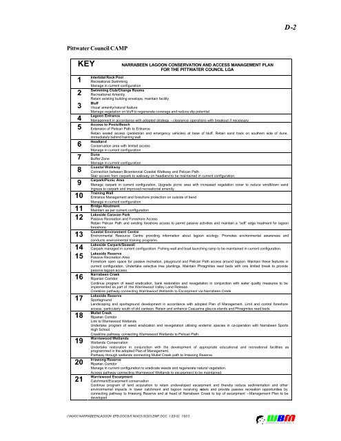
D-2<br />
Pittwater <strong>Council</strong> CAMP<br />
KEY<br />
1<br />
2<br />
3<br />
4<br />
5<br />
6<br />
7<br />
8<br />
9<br />
10<br />
11<br />
12<br />
13<br />
14<br />
15<br />
16<br />
17<br />
18<br />
19<br />
20<br />
21<br />
NARRABEEN LAGOON CONSERVATION AND ACCESS MANAGEMENT PLAN<br />
FOR THE PITTWATER COUNCIL LGA<br />
Intertidal Rock Pool<br />
Recreational Swimming<br />
Manage in current configuration<br />
Swimming Club/Change Rooms<br />
Recreational Amenity<br />
Retain existing building envelope, maintain facility<br />
Bluff<br />
Visual amenity/natural feature<br />
Manage vegetation on bluff to regenerate coverage and reduce slip potential<br />
<strong>Lagoon</strong> Entrance<br />
<strong>Management</strong> in accordance with adopted strategy – clearance operations with breakout if necessary<br />
Access to Pools/Beach<br />
Extension of Pelican Path to Entrance<br />
Retain sealed access (pedestrian and emergency vehicles) at base of bluff. Retain sand track on southern side of dune,<br />
immediately behind training wall.<br />
Headland<br />
Conservation area with limited access<br />
Manage in current configuration<br />
Dune<br />
Buffer Zone<br />
Manage in current configuration<br />
Coastal Walkway<br />
Connection between Bicentennial Coastal Walkway and Pelican Path<br />
Stair access from carpark to walkway on headland to be maintained in current configuration.<br />
Carpark/Picnic Area<br />
Manage carpark in current configuration. Upgrade picnic area with increased vegetation cover to reduce windblown sand<br />
ingress to carpark and improved recreational amenity.<br />
Training Wall<br />
Entrance <strong>Management</strong> and foreshore protection on outside of bend<br />
Manage in current configuration<br />
Bridge Abutment<br />
Maintain as per current configuration<br />
Lakeside Caravan Park<br />
Passive Recreation and Foreshore Access<br />
Retain Pelican Path and existing foreshore access to permit passive activities and maintain a “soft” edge treatment for lagoon<br />
foreshore.<br />
Coastal Environment Centre<br />
Environmental Resource Centre providing information about lagoon ecology. Promotes environmental awareness and<br />
conducts environmental training programs.<br />
Lakeside Carpark/Seawall<br />
Carpark managed in current configuration. Fishing wall and boat launching ramp to be maintained in current configuration.<br />
Lakeside Reserve<br />
Passive Recreation Area<br />
Foreshore open space for passive recreation, playground and Pelican Path access around lagoon. Maintain these features in<br />
current configuration. Undertake selective tree plantings. Maintain Phragmites reed beds with one limited break to provide<br />
passive lagoon access.<br />
<strong>Narrabeen</strong> Creek<br />
Riparian Corridor<br />
Continue program of weed eradication, bank restoration and revegetation in conjunction with water quality measures to be<br />
implemented as part of the Warriewood Valley Land Release.<br />
Creekline pathway connecting Warriewood Wetlands to Escarpment via <strong>Narrabeen</strong> Creek<br />
Lakeside Reserve<br />
Sportsground<br />
Landscaping and sportsground development in accordance with adopted <strong>Plan</strong> of <strong>Management</strong>. Limit and control foreshore<br />
access, particularly south of old canteen. Retain and enhance Casuarina glauca stands and Phragmites reed beds.<br />
Mullet Creek<br />
Riparian Corridor<br />
Link to Warriewood Wetlands<br />
Undertake program of weed eradication and revegetation utilising endemic species in co-operation with <strong>Narrabeen</strong> Sports<br />
High School.<br />
Creekline pathway connecting Warriewood Wetlands to Pelican Path.<br />
Warriewood Wetlands<br />
Wetlands Conservation<br />
Undertake restoration in conjunction with the development of appropriate educational and recreational facilities as<br />
programmed in the adopted <strong>Plan</strong> of <strong>Management</strong>.<br />
Pathway through wetlands connecting Mullet Creek path to Irrawong Reserve.<br />
Irrawong Reserve<br />
Riparian Corridor<br />
Manage in current configuration to eradicate weeds and regenerate natural vegetation.<br />
Access pathway connecting Warriewood Wetlands to escarpment to be maintained.<br />
Warriewood Escarpment<br />
Catchment/Escarpment conservation<br />
Continue program of land acquisition to retain undeveloped escarpment and thereby reduce sedimentation and other<br />
environmental impacts in lower catchment and lagoon receiving waters and provide passive recreation opportunities by<br />
connecting pathway to Irrawong Reserve and at head of <strong>Narrabeen</strong> Creek to top of escarpment – <strong>Management</strong> <strong>Plan</strong> to be<br />
developed.<br />
I:\N0433 NARRABEEN LAGOON EPS\DOCS\R.N0433.003.03.EMP.DOC 12/3/02 16:03<br />
OCEANICS AUSTRALIA