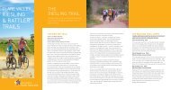
4WD Tracks & Repeater Towers brochure - South Australia
4WD Tracks & Repeater Towers brochure - South Australia
4WD Tracks & Repeater Towers brochure - South Australia

Create successful ePaper yourself
Turn your PDF publications into a flip-book with our unique Google optimized e-Paper software.
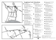
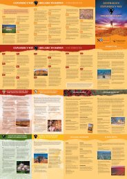
Public Access Routes (PARs)<br />
PAR 1. Copper King Mine<br />
Public Access Route – 5km<br />
Easily accessible via bitumen road approximately 17km south from Leigh<br />
Creek. Take the Beltana road and access via the Copper Mine. Camping is<br />
available adjacent to the creek line at Ajax bore.<br />
The access track, though only a few kilometres long, is rough in places and a<br />
high clearance <strong>4WD</strong> vehicle is recommended.<br />
PAR 2. Lake Eyre (Level Post Bay via Muloorina)<br />
Public Access Route – 51km<br />
This access route can be traversed by 2 wheel drive vehicles if it has been<br />
recently graded, however, during the summer and dry periods, a <strong>4WD</strong> vehicle<br />
is recommended. It is recommended that visitors use the serviced camping<br />
site at the Frome Creek Waterhole near Muloorina Homestead. The camping<br />
charge is donated to the Royal Flying Doctor Service.<br />
No other services are provided. Please ensure you have adequate food<br />
and water for your trip and are equipped with a UHF radio for contact with<br />
surrounding stations (channel 30, or channel 7 repeater), or satellite phone in<br />
case of breakdown.<br />
PAR 3. Nuccaleena Mine<br />
Public Access Route – 14km<br />
The track surface is rough and rocky in places. A <strong>4WD</strong> vehicle with high<br />
clearance is essential. A camping area is provided near the site of the mine<br />
ruins. The Nuccaleena mine site has many open cut mine areas and deep<br />
shafts. Please exercise extreme care when walking around the site. If you<br />
intend to access the underground adit (horizontal shaft), please ensure you<br />
have a hard hat and torch and do not go past the safety barrier.<br />
PAR 4. Artimore and<br />
PAR 5. Patawarta Gap<br />
Public Access Routes – 26km and 6km<br />
These two routes are rough and should only be attempted by experienced<br />
<strong>4WD</strong> operators with well-equipped high-clearance <strong>4WD</strong> vehicles. There are<br />
numerous creek crossings and washouts are common along the length of<br />
these two tracks, as well as in the rest of the Flinders Ranges.<br />
To access Patawarta Gap, take the turnoff heading north off the Artimore route,<br />
a few kilometres east of Moolooloo Homestead. Camping is allowed within<br />
50m of these routes but not within 500m of any stock watering point or within<br />
a kilometre of any station homestead or other building. There is a camping area<br />
near the Artimore Homestead ruins. Do not camp in creekbeds.<br />
PAR 6. Tallaringa<br />
Public Access Route – 62km<br />
The Tallaringa Route begins 44km west of Coober Pedy, adjacent to Mabel<br />
Creek Station homestead and is marked by a detailed information shelter.<br />
The Tallaringa Route itself is approximately 62km long and provides access to the<br />
Tallaringa Conservation Park and the Anne Beadell Highway. The highway is an<br />
overgrown and corrugated track heading west from Mabel Creek to Laverton in<br />
WA across the Great Victoria Desert, a total distance of 1296km with no services<br />
available.<br />
Camping is not allowed on Mabel Creek Station – elsewhere it is allowed<br />
within 100m of the track. Take care with fire, particularly after good seasons<br />
with abundant grass growth.<br />
If you are travelling on to Tallaringa Conservation Park you will require a<br />
Desert Parks Pass or overnight camping permit: call 1800 816 078. If you are<br />
continuing further west to Laverton, you will require a permit for the Maralinga<br />
Tjarutja Aboriginal Land (phone 08 8625 2946, four to six weeks notice is<br />
required), Woomera Prohibited Area (phone 08 8674 3370) and the Unnamed<br />
Conservation Park (phone 08 8625 3144).<br />
PAR 8. Pedirka<br />
Public Access Route – 43km<br />
The Pedirka Route starts at the terminus of the existing public road at Hamilton<br />
Station and traverses downstream and along the north bank of the Hamilton<br />
Creek, crossing the old Ghan line at Pedirka siding. It is often used as the<br />
preferred route to the Rig Road or French Line in Simpson Desert National Park<br />
via Purnie Bore. It is approximately 80km from Hamilton Station to Dalhousie<br />
Springs. A Desert Parks Pass is required to enter Witjira National Park and the<br />
Simpson Desert Regional Reserve: call 1800 816 078.<br />
<strong>4WD</strong> vehicles properly equipped for outback travel are needed when accessing<br />
Witjira via this route as deep sand drifts, washouts and rough rocky stretches<br />
are common. There is limited sight distance in some areas so please travel<br />
slowly and carry a flag and pole for visibility over dune crests. This track,<br />
like other roads in the region, can be rendered impassable by heavy rainfalls<br />
for weeks at a time. Do not attempt to travel to Dalhousie Springs and the<br />
Simpson Desert if significant rain is forecast or has fallen in the area.<br />
Camping is allowed within 250m of this track, but not within 500m of a<br />
constructed stock watering point or 1km of any station building. Avoid camping<br />
in Stevenson Creek as it is easy to bog vehicles in the deep sand of the main<br />
river channels.<br />
PAR 9. Warraweena<br />
Public Access Route – 22km<br />
A high clearance <strong>4WD</strong> vehicle is needed on the Warraweena Route as the track<br />
has many steep creek crossings, with areas of the track surface comprising<br />
large rocks and areas where the soils have become eroded and gullied.<br />
Warraweena is a private conservation park and a fee is payable to access<br />
any area of the property from this or other tracks. No fee applies if you are<br />
only staying on the PAR. Please call at homestead before traversing the PAR.<br />
Camping is not allowed along this track. Serviced camping areas are provided<br />
away from the track, however a fee is required and bookings are essential.<br />
Please enquire at the homestead.<br />
There is no public access beyond the Narrina Station boundary fence without<br />
prior permission from Narrina station.<br />
Contact (08) 8675 2770<br />
warraweena@internode.on.net<br />
www.warraweena.com<br />
PAR 10. Lake Gairdner National Park<br />
Public Access Route – 2.5km<br />
A short track off the Kingoonya to Iron Knob Road, about 25km north of the<br />
Pondanna out station ruins (Yardea Station turnoff).<br />
A natural camping area is provided – watch out for signs. No facilities are<br />
available, so please keep the area tidy and keep fires small to conserve wood<br />
supplies.<br />
Do not attempt to drive on the lake surface; apart from the significant risk of<br />
bogging, vehicle tracks will spoil the natural appearance of this unique area.<br />
PAR 11. Gawler Ranges National Park<br />
Public Access Route – 20km (Park Boundary)<br />
27km (Paney Homestead)<br />
Map Area<br />
SOUTH AUSTRALIA<br />
This track provides access to Gawler Ranges National Park from Kimba, or the<br />
Gawler Ranges road via Yardea. The turn off is about 60km from Kimba and<br />
15km north of Buckleboo Station homestead.<br />
Camping is available at Paney Homestead in the National Park. Please do not<br />
camp along this access route to the park.<br />
Map Area<br />
SOUTH AUSTRALIA<br />
PAR 7. Curdimurka and<br />
PAR 14. Strangways Springs<br />
Public Access Routes – 1km and 2.5km<br />
Symbol Legend<br />
Accommodation<br />
Informal camping is allowed at the terminus of the Curdimurka route, however,<br />
please bring your own firewood or use fuel stoves. Camping is not permitted at<br />
the Strangways Springs Ruins.<br />
Ensure you have sufficient food and water supplies and reliable communication<br />
(satellite phone or HF radio with RFDS frequencies) if travelling the Oodnadatta<br />
Track, particularly during the warmer months (November to March).<br />
Low ratio<br />
High clearance<br />
Some <strong>4WD</strong> experience<br />
necessary<br />
Camping<br />
Caravan<br />
½ day track<br />
Full day track<br />
Fees apply<br />
Outback Area<br />
See map over for<br />
PAR locations<br />
SOUTH AUSTRALIA