4WD Tracks & Repeater Towers brochure - South Australia
4WD Tracks & Repeater Towers brochure - South Australia
4WD Tracks & Repeater Towers brochure - South Australia

Create successful ePaper yourself
Turn your PDF publications into a flip-book with our unique Google optimized e-Paper software.
<strong>South</strong> <strong>Australia</strong><br />
Flinders Ranges,<br />
Eyre Peninsula and Outback<br />
<strong>4WD</strong> <strong>Tracks</strong> &<br />
<strong>Repeater</strong> <strong>Towers</strong><br />
Take the road less travelled<br />
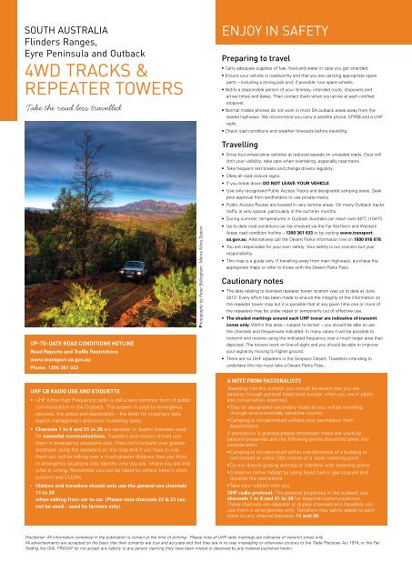
Enjoy in safety<br />
Preparing to travel<br />
• Carry adequate supplies of fuel, food and water in case you get stranded.<br />
• Ensure your vehicle is roadworthy and that you are carrying appropriate spare<br />
parts – including a strong jack and, if possible, two spare wheels.<br />
• Notify a responsible person of your itinerary, intended route, stopovers and<br />
arrival times and dates. Then contact them when you arrive at each notified<br />
stopover.<br />
• Normal mobile phones do not work in most SA outback areas away from the<br />
sealed highways. We recommend you carry a satellite phone, EPIRB and a UHF<br />
radio.<br />
• Check road conditions and weather forecasts before travelling.<br />
UP-TO-DATE ROAD CONDITIONS HOTLINE<br />
Road Reports and Traffic Restrictions<br />
www.transport.sa.gov.au<br />
Phone: 1300 361 033<br />
Photography by Peter Bellingham. Merna Mora Station<br />
Travelling<br />
• Drive four-wheel-drive vehicles at reduced speeds on unsealed roads. Dust will<br />
limit your visibility; take care when overtaking, especially road trains.<br />
• Take frequent rest breaks and change drivers regularly.<br />
• Obey all road closure signs.<br />
• If you break down DO NOT LEAVE YOUR VEHICLE.<br />
• Use only recognised Public Access <strong>Tracks</strong> and designated camping areas. Seek<br />
prior approval from landholders to use private tracks.<br />
• Public Access Routes are located in very remote areas. On many Outback tracks<br />
traffic is very sparse, particularly in the summer months.<br />
• During summer, temperatures in Outback <strong>Australia</strong> can reach over 40°C (104°F).<br />
• Up-to-date road conditions can be checked via the Far Northern and Western<br />
Areas road condition hotline – 1300 361 033 or by visiting www.transport.<br />
sa.gov.au. Alternatively call the Desert Parks information line on 1800 816 078.<br />
• You are responsible for your own safety. Your safety is our concern but your<br />
responsibility.<br />
• This map is a guide only. If travelling away from main highways, purchase the<br />
appropriate maps or refer to those with the Desert Parks Pass.<br />
Cautionary notes<br />
• The data relating to licensed repeater tower location was up to date at June<br />
2010. Every effort has been made to ensure the integrity of the information on<br />
the repeater tower map but it is possible that at any given time one or more of<br />
the repeaters may be under repair or temporarily out of effective use.<br />
• The shaded markings around each UHF tower are indicative of transmit<br />
zones only. Within this area – subject to terrain – you should be able to use<br />
the channels and frequencies indicated. In many cases it will be possible to<br />
transmit and receive using the indicated frequency over a much larger area than<br />
depicted. The towers work on line-of-sight and you should be able to improve<br />
your signal by moving to higher ground.<br />
• There are no UHF repeaters in the Simpson Desert. Travellers intending to<br />
undertake this trip must take a Desert Parks Pass.<br />
Uhf cb radio use and etiquette<br />
• UHF (Ultra High Frequency) radio is still a very common form of public<br />
communication in the Outback. The system is used by emergency<br />
services, the police and pastoralists – the latter for important daily<br />
station management and stock mustering tasks.<br />
• Channels 1 to 8 and 31 to 38 are repeater or duplex channels used<br />
for essential communications. Travellers and visitors should use<br />
them in emergency situations only. They communicate over greater<br />
distances using the repeaters on this map and if you have to use<br />
them you will be talking over a much greater distance than you think.<br />
In emergency situations only identify who you are, where you are and<br />
what is wrong. Remember you can be heard by others: keep it short,<br />
succinct and CLEAN.<br />
• Visitors and travellers should only use the general use channels<br />
11 to 30<br />
when talking from car to car. (Please note channels 22 & 23 can<br />
not be used – used by farmers only).<br />
A NOTE FROM PASTORALISTS<br />
Travelling into the outback you should be aware that you are<br />
passing through pastoral lease land (except when you are in parks<br />
and conservation reserves).<br />
• Stay on designated secondary roads as you will be travelling<br />
through environmentally sensitive country<br />
• Camping is not permitted without prior permission from<br />
leaseholders.<br />
If permission is granted please remember these are working<br />
pastoral properties and the following points should be taken into<br />
consideration:<br />
• Camping is not permitted within one kilometre of a building or<br />
homestead or within 500 metres of a stock watering point<br />
• Do not disturb grazing animals or interfere with watering points<br />
• Conserve native habitat by using liquid fuel or gas cookers and<br />
observe fire restrictions<br />
• Take your rubbish with you.<br />
UHF radio protocol: The pastoral properties in the outback use<br />
channels 1 to 8 and 31 to 38 for essential communications.<br />
These channels are repeater or duplex channels and travellers can<br />
use them in emergencies only. Travellers may safely speak to each<br />
other on any channel between 11 and 30.<br />
Disclaimer: All information contained in the publication is correct at the time of printing. Please note all UHF radio markings are indicative of transmit zones only.<br />
All advertisements are accepted on the basis that their contents are true and accurate and that they are in no way misleading or otherwise contrary to the Trade Practices Act 1974, or the Fair<br />
Trading Act (SA). FROSAT do not accept any liability to any person claiming they have been misled or deceived by any material published herein.
<strong>4WD</strong> <strong>Tracks</strong><br />
The Flinders Ranges have long been celebrated for their beauty and<br />
variety of landscape. Beyond them are the great spaces of the Outback.<br />
When travelling south to the Eyre Peninsula you experience spectacular<br />
coastline ranging from towering limestone cliffs, sweeping surf beaches<br />
and sheltered coves.<br />
A trip combining all three – the ranges, vast outback landscapes and<br />
rugged coastline – is one of the most memorable to be made anywhere<br />
in <strong>Australia</strong>.<br />
One of <strong>Australia</strong>’s most scenic and wonderfully diverse regions, the<br />
Flinders Ranges are a must for any <strong>4WD</strong> enthusiast. Its peaceful and<br />
awe-inspiring landscape of rugged jag-edged mountains, river red gum<br />
lined gorges and ever-changing colours both humble and inspire. Wildlife<br />
is abundant here, with kangaroos, lizards, emus and wedge-tailed eagles<br />
a common sight.<br />
The Outback has some of the greatest desert <strong>4WD</strong> destinations in the<br />
world. The tracks here are your path to exploring permanent waterholes,<br />
historic sites and vast salt lakes. Follow the trails blazed by explorers,<br />
stockmen and Afghan camel drivers, the Overland Telegraph and the<br />
original Ghan Railway.<br />
Eyre Peninsula offers a diverse four-wheel drive experience including<br />
towering sand dunes and beautiful beaches amidst rugged limestone<br />
cliffs and abundant wild life.<br />
In recent years extensive tracts of terrain have been opened for <strong>4WD</strong><br />
exploration, adding to the variety of <strong>4WD</strong> experiences on offer. Many<br />
station properties have developed self-drive tracks, tag-along routes,<br />
bush camping and accommodation to create a wide range of off-road<br />
experiences previously unavailable to recreational four-wheel drivers. The<br />
routes on these properties combine serious driving with seclusion and<br />
stunning views.<br />
In addition, Outback travellers can now use Public Access Routes (PARs)<br />
in our rangeland and pastoral country. Each PAR is sign-posted with<br />
specific information regarding usage of the route, so please read the signs<br />
before traversing each PAR. Be aware that most PARs cross privately<br />
owned working pastoral properties.<br />
If you are planning your first <strong>4WD</strong> trip consider taking a <strong>4WD</strong> course in<br />
your own vehicle before setting out.<br />
Visitor information<br />
Pick yourself up a Flinders Ranges & Outback Visitor Guide for other handy<br />
information to assist you with your travels in the region.<br />
Flinders Ranges and Outback <strong>South</strong> <strong>Australia</strong><br />
www.flindersoutback.com<br />
1800 633 060<br />
Wadlata Outback Interpretive Centre<br />
41 Flinders Terrace, Port Augusta<br />
Coober Pedy Visitor Information Centre<br />
Hutchinson Street, Coober Pedy<br />
Flinders Ranges Visitor Information Centre<br />
Seventh Street, Quorn<br />
Hawker Visitor Information Centre<br />
Cnr Wilpena and Cradock Road, Hawker<br />
Port Pirie Tourism and Arts Centre<br />
3 Mary Elie Street, Port Pirie<br />
Roxby Downs Visitor Information Centre<br />
7 Richardson Place, Roxby Downs<br />
Wilpena Pound Visitor Information Centre<br />
Wilpena Pound Resort<br />
Woomera Heritage Centre<br />
Dewrang Avenue, Woomera<br />
Eyre Peninsula<br />
www.eyrepeninsula.info<br />
1800 067 739<br />
Ceduna Visitor Information Centre<br />
Poynton Street, Ceduna<br />
Whyalla Visitor Information Centre<br />
Lincoln Highway, Whyalla<br />
Port Lincoln Visitor Information Centre<br />
Adelaide Place, Port Lincoln<br />
Elliston Visitor Information Centre<br />
6 Memorial Drive, Elliston<br />
Department of Environment, water and Natural Resources<br />
Desert Parks Pass Hotline: 1800 816 078<br />
www.environment.sa.gov.au<br />
Toll free phone for public access information: 1800 678 447<br />
www.dwlbc.sa.gov.au<br />
Disclaimer: All information contained in the publication is correct at the time of printing.<br />
Please note all UHF radio markings are indicative of transmit zones only.<br />
All advertisements are accepted on the basis that their contents are true and accurate and<br />
that they are in no way misleading or otherwise contrary to the Trade Practices Act 1974,<br />
or the Fair Trading Act (SA). FROSAT do not accept any liability to any person claiming they<br />
have been misled or deceived by any material published herein.<br />
Discover the Outback<br />
with a Desert Parks Pass<br />
A Desert Parks Pass is your passport to <strong>South</strong> <strong>Australia</strong>’s<br />
breathtaking arid landscapes by <strong>4WD</strong>.<br />
The pass allows entry into the following eight parks and covers<br />
camping (where permitted). When you purchase a Desert<br />
Parks Pass you will receive a handbook with information on the<br />
parks, safety instructions for outback driving, vehicle supply<br />
checklists, wildlife information and detailed maps.<br />
• Witjira National Park<br />
• Simpson Desert Regional Reserve and Conservation Park<br />
• Wabma Kadarbu Mound Springs Conservation Park<br />
• Lake Eyre National Park<br />
• Tallaringa Conservation Park<br />
• Innamincka Regional Reserve<br />
• Coongie Lakes National Park<br />
The pass is valid for 12 months and is issued on a per<br />
vehicle basis.<br />
For Further Information:<br />
Desert Parks Pass Hotline 1800 816 078<br />
www.parks.sa.gov.au<br />
Please remember, that although beautiful, the<br />
desert is a harsh and unforgiving environment<br />
for the unprepared traveller. Familiarising<br />
yourself with the detailed safety and trip-planning<br />
information in your Desert Parks handbook<br />
before you leave is the first step to ensure you’ll<br />
get the most out of your desert adventure.
Public Access Routes (PARs)<br />
PAR 1. Copper King Mine<br />
Public Access Route – 5km<br />
Easily accessible via bitumen road approximately 17km south from Leigh<br />
Creek. Take the Beltana road and access via the Copper Mine. Camping is<br />
available adjacent to the creek line at Ajax bore.<br />
The access track, though only a few kilometres long, is rough in places and a<br />
high clearance <strong>4WD</strong> vehicle is recommended.<br />
PAR 2. Lake Eyre (Level Post Bay via Muloorina)<br />
Public Access Route – 51km<br />
This access route can be traversed by 2 wheel drive vehicles if it has been<br />
recently graded, however, during the summer and dry periods, a <strong>4WD</strong> vehicle<br />
is recommended. It is recommended that visitors use the serviced camping<br />
site at the Frome Creek Waterhole near Muloorina Homestead. The camping<br />
charge is donated to the Royal Flying Doctor Service.<br />
No other services are provided. Please ensure you have adequate food<br />
and water for your trip and are equipped with a UHF radio for contact with<br />
surrounding stations (channel 30, or channel 7 repeater), or satellite phone in<br />
case of breakdown.<br />
PAR 3. Nuccaleena Mine<br />
Public Access Route – 14km<br />
The track surface is rough and rocky in places. A <strong>4WD</strong> vehicle with high<br />
clearance is essential. A camping area is provided near the site of the mine<br />
ruins. The Nuccaleena mine site has many open cut mine areas and deep<br />
shafts. Please exercise extreme care when walking around the site. If you<br />
intend to access the underground adit (horizontal shaft), please ensure you<br />
have a hard hat and torch and do not go past the safety barrier.<br />
PAR 4. Artimore and<br />
PAR 5. Patawarta Gap<br />
Public Access Routes – 26km and 6km<br />
These two routes are rough and should only be attempted by experienced<br />
<strong>4WD</strong> operators with well-equipped high-clearance <strong>4WD</strong> vehicles. There are<br />
numerous creek crossings and washouts are common along the length of<br />
these two tracks, as well as in the rest of the Flinders Ranges.<br />
To access Patawarta Gap, take the turnoff heading north off the Artimore route,<br />
a few kilometres east of Moolooloo Homestead. Camping is allowed within<br />
50m of these routes but not within 500m of any stock watering point or within<br />
a kilometre of any station homestead or other building. There is a camping area<br />
near the Artimore Homestead ruins. Do not camp in creekbeds.<br />
PAR 6. Tallaringa<br />
Public Access Route – 62km<br />
The Tallaringa Route begins 44km west of Coober Pedy, adjacent to Mabel<br />
Creek Station homestead and is marked by a detailed information shelter.<br />
The Tallaringa Route itself is approximately 62km long and provides access to the<br />
Tallaringa Conservation Park and the Anne Beadell Highway. The highway is an<br />
overgrown and corrugated track heading west from Mabel Creek to Laverton in<br />
WA across the Great Victoria Desert, a total distance of 1296km with no services<br />
available.<br />
Camping is not allowed on Mabel Creek Station – elsewhere it is allowed<br />
within 100m of the track. Take care with fire, particularly after good seasons<br />
with abundant grass growth.<br />
If you are travelling on to Tallaringa Conservation Park you will require a<br />
Desert Parks Pass or overnight camping permit: call 1800 816 078. If you are<br />
continuing further west to Laverton, you will require a permit for the Maralinga<br />
Tjarutja Aboriginal Land (phone 08 8625 2946, four to six weeks notice is<br />
required), Woomera Prohibited Area (phone 08 8674 3370) and the Unnamed<br />
Conservation Park (phone 08 8625 3144).<br />
PAR 8. Pedirka<br />
Public Access Route – 43km<br />
The Pedirka Route starts at the terminus of the existing public road at Hamilton<br />
Station and traverses downstream and along the north bank of the Hamilton<br />
Creek, crossing the old Ghan line at Pedirka siding. It is often used as the<br />
preferred route to the Rig Road or French Line in Simpson Desert National Park<br />
via Purnie Bore. It is approximately 80km from Hamilton Station to Dalhousie<br />
Springs. A Desert Parks Pass is required to enter Witjira National Park and the<br />
Simpson Desert Regional Reserve: call 1800 816 078.<br />
<strong>4WD</strong> vehicles properly equipped for outback travel are needed when accessing<br />
Witjira via this route as deep sand drifts, washouts and rough rocky stretches<br />
are common. There is limited sight distance in some areas so please travel<br />
slowly and carry a flag and pole for visibility over dune crests. This track,<br />
like other roads in the region, can be rendered impassable by heavy rainfalls<br />
for weeks at a time. Do not attempt to travel to Dalhousie Springs and the<br />
Simpson Desert if significant rain is forecast or has fallen in the area.<br />
Camping is allowed within 250m of this track, but not within 500m of a<br />
constructed stock watering point or 1km of any station building. Avoid camping<br />
in Stevenson Creek as it is easy to bog vehicles in the deep sand of the main<br />
river channels.<br />
PAR 9. Warraweena<br />
Public Access Route – 22km<br />
A high clearance <strong>4WD</strong> vehicle is needed on the Warraweena Route as the track<br />
has many steep creek crossings, with areas of the track surface comprising<br />
large rocks and areas where the soils have become eroded and gullied.<br />
Warraweena is a private conservation park and a fee is payable to access<br />
any area of the property from this or other tracks. No fee applies if you are<br />
only staying on the PAR. Please call at homestead before traversing the PAR.<br />
Camping is not allowed along this track. Serviced camping areas are provided<br />
away from the track, however a fee is required and bookings are essential.<br />
Please enquire at the homestead.<br />
There is no public access beyond the Narrina Station boundary fence without<br />
prior permission from Narrina station.<br />
Contact (08) 8675 2770<br />
warraweena@internode.on.net<br />
www.warraweena.com<br />
PAR 10. Lake Gairdner National Park<br />
Public Access Route – 2.5km<br />
A short track off the Kingoonya to Iron Knob Road, about 25km north of the<br />
Pondanna out station ruins (Yardea Station turnoff).<br />
A natural camping area is provided – watch out for signs. No facilities are<br />
available, so please keep the area tidy and keep fires small to conserve wood<br />
supplies.<br />
Do not attempt to drive on the lake surface; apart from the significant risk of<br />
bogging, vehicle tracks will spoil the natural appearance of this unique area.<br />
PAR 11. Gawler Ranges National Park<br />
Public Access Route – 20km (Park Boundary)<br />
27km (Paney Homestead)<br />
Map Area<br />
SOUTH AUSTRALIA<br />
This track provides access to Gawler Ranges National Park from Kimba, or the<br />
Gawler Ranges road via Yardea. The turn off is about 60km from Kimba and<br />
15km north of Buckleboo Station homestead.<br />
Camping is available at Paney Homestead in the National Park. Please do not<br />
camp along this access route to the park.<br />
Map Area<br />
SOUTH AUSTRALIA<br />
PAR 7. Curdimurka and<br />
PAR 14. Strangways Springs<br />
Public Access Routes – 1km and 2.5km<br />
Symbol Legend<br />
Accommodation<br />
Informal camping is allowed at the terminus of the Curdimurka route, however,<br />
please bring your own firewood or use fuel stoves. Camping is not permitted at<br />
the Strangways Springs Ruins.<br />
Ensure you have sufficient food and water supplies and reliable communication<br />
(satellite phone or HF radio with RFDS frequencies) if travelling the Oodnadatta<br />
Track, particularly during the warmer months (November to March).<br />
Low ratio<br />
High clearance<br />
Some <strong>4WD</strong> experience<br />
necessary<br />
Camping<br />
Caravan<br />
½ day track<br />
Full day track<br />
Fees apply<br />
Outback Area<br />
See map over for<br />
PAR locations<br />
SOUTH AUSTRALIA
Public Access Routes (PARs)<br />
PAR 12. Old Peake Telegraph Station<br />
Public Access Route – 16km<br />
This Route is approximately 95km south of Oodnadatta along the Oodnadatta<br />
Track or 110km north of William Creek. Camping is available in the creek line<br />
near the ruins complex. <strong>4WD</strong> access only.<br />
PAR 13. Lake Eyre (Halligan Point)<br />
Public Access Route – 62km<br />
The start of this Route is approximately 7km southeast of William Creek on<br />
the Oodnadatta Track, but should not be attempted during summer or if rain<br />
has fallen or is forecast for the area. Camping is allowed along the route or<br />
within 250m of it, but not within 500m of a stock watering point or 1km of any<br />
station building. Once in the park camping is only allowed where indicated near<br />
Halligan Point.<br />
Stay on the track and do not attempt to drive onto the lake surface. People<br />
have perished in this area after becoming bogged.<br />
PAR 15. K1 (Warburton Crossing)<br />
Public Access Route – 80km<br />
This Route provides access to the start of Simpson Desert Regional Reserve. A<br />
Desert Parks Pass is required: call 1800 816 078. The Warburton Crossing itself<br />
is located approximately 10km from the start of the route. Access is from the<br />
Birdsville track.<br />
Camping is available 250m either side of the route, however avoid areas<br />
near stock watering points. Camping is prohibited within 500m of any stock<br />
watering point.<br />
Vehicles attempting to cross the Simpson Desert should be well equipped for<br />
remote areas with a satellite phone or HF radio with RFDS frequencies. It is<br />
inadvisable to take a trailer or any towed vehicle into the desert. Information on<br />
attempting a Simpson Desert Crossing can be obtained from the Desert Parks<br />
information line 1800 816 078.<br />
Please heed their advice.<br />
PAR 16. Walkers Crossing<br />
Public Access Route – 226km<br />
Accessible to <strong>4WD</strong> vehicles only. This route can be closed for months after<br />
local heavy rains, or when the Cooper system comes down in flood. Do not<br />
attempt this route if rains have fallen or are forecast for the area; take heed of<br />
local information on track conditions.<br />
The Walkers Crossing route can be reached from either the Birdsville Track,<br />
or Innamincka. From the Birdsville Track, the turn off is 72km north of the<br />
Clifton Hills Homestead turnoff or 122km south of Birdsville. From Innamincka<br />
access is via the 15 Mile track which forms part of the Walkers Crossing<br />
route. At the end of the 15 Mile Track, turn north and take the turn off to<br />
the left approximately 8km on the track towards Gidgealpa. Look out for the<br />
fingerboard signs at most intersections.<br />
Camping is available in Innamincka Regional Reserve or along Cooper Creek.<br />
PAR 17. Arckaringa Hills<br />
Public Access Route – 2km<br />
Accessible from the Oodnadatta to Arckaringa track, take the turnoff towards<br />
Arckaringa, approximately 50km from Oodnadatta. The route is located<br />
approximately 10km from Arckaringa Homestead. The route turns off to the<br />
north from near a fence line grid. A two wheel drive vehicle can be used on<br />
this track. However, if rain is forecast or is threatening, it is advisable to leave<br />
the area, as any heavy rains will cut the Oodnadatta – Coober Pedy track via<br />
Arckaringa for up to a week.<br />
No camping is allowed in this area. A camping area is provided at the<br />
Arckaringa homestead.<br />
PAR 18. Lake Cadibarrawirracanna<br />
Public Access Route – 6.5km<br />
Access is from the Coober Pedy to William Creek road, approximately 88km<br />
east of Coober Pedy, or 77km from William Creek. Camping is permitted at the<br />
end of this route – by a saline creekline that feeds into the Lake from the south.<br />
Please bring your own firewood or use a fuel stove and note that the water in<br />
the creek is too salty to drink.<br />
Do not attempt to drive further north or onto the lake shore or the lake itself –<br />
this country is very soft and easily damaged; it is also treacherous for vehicles<br />
and walking for help from this locality would be life-threatening in hot weather.<br />
PAR 19. Algebuckina Bridge and Waterhole<br />
Public Access Route – 500m to the bridge and<br />
1.5km to waterhole & campsite<br />
The Algebuckina Bridge is highly visible and easily reached from off the<br />
Oodnadatta Track. Do not attempt to travel when the track is wet. Stay within<br />
the safety barriers when visiting the Bridge itself.<br />
A campsite has been established on the east side of the Oodnadatta Track<br />
approx 1.5km from the bridge and camping is restricted to this area. Do not use<br />
local firewood and please remove all rubbish and bury human waste well away<br />
from the waterhole.<br />
PAR 22. Goog’s Track<br />
Public Access Route – 230kms Ceduna-Tarcoola<br />
350km Ceduna-Glendambo<br />
Recommended for experienced Outback travellers with a well-equipped <strong>4WD</strong><br />
vehicle. With more than 360 sand dunes, the easiest way to tackle this track<br />
is in a south to north direction. The sand ridges range up to 25m high and it is<br />
important to watch for oncoming vehicles; everyone travelling south to north<br />
reduces the chance of a head-on collision on the crests.<br />
To access the track, take the Kananbi Road north from Ceduna. The actual<br />
PAR runs for 22km from the northern edge of the Yellabinna Regional Reserve,<br />
through Kychering Pastoral Lease (Wilgena) to the Transcontinental Rail line.<br />
Stay on the defined tracks and do not detour to any lake surfaces. Conditions<br />
are generally good, however reduce tyre pressures to avoid track damage.<br />
Camping is available throughout the Yellabinna Regional Reserve and there’s a<br />
great shady campsite near Goog’s Lake with some interesting side trips. Further<br />
north, Mount Finke also offers camping and views over the dunes. Campfires<br />
are not allowed during the fire ban season from November to April; use gas<br />
barbeques, except on total fire ban days.<br />
Bush camping requires a permit, available from DEH’s Ceduna office, the<br />
Ceduna Tourist Information Centre or by phone (08) 8625 3144.<br />
This is a very remote area – ensure you are self-sufficient with adequate water,<br />
food, fuel and medical supplies. Also ensure your vehicle has spares and<br />
reliable communications (satellite phone or HF radio with RFDS frequencies).<br />
To communicate with surrounding stations, use UHF channel 18.<br />
Contact National Parks Ceduna (08) 8625 3144<br />
PAR 23. Nonning<br />
Public Access Route – 55km<br />
This track is only suitable for <strong>4WD</strong>s and links a popular route from the<br />
Gawler Ranges Mail Road to Kimba in the south. From Nonning to Kimba is<br />
approximately 85kms, with the PAR crossing through a working pastoral lease<br />
for 55kms in the southern Gawler Ranges region.<br />
The northern turn-off is 72kms north west of Iron Knob, about 1km past the<br />
Nonning Homestead. To access the track from Kimba, travel 8kms along the<br />
Buckleboo Road to Drekumi Road, then north for 20kms.<br />
Camping is permitted within 250 metres of the track but not within 500 metres<br />
of a stock watering point or within 1km of a building.<br />
Please respect any stock or infrastructure that you may encounter<br />
along the route.<br />
This is a remote area – ensure you are self-sufficient with adequate water,<br />
food, fuel and medical supplies. Also ensure your vehicle has spares and<br />
reliable communications (satellite phone or HF radio with RFDS frequencies).<br />
PAR 24. Secret Rocks<br />
Public Access Route –<br />
44km south east of Kimba on the main road to Whyalla – allow 3 hours return.<br />
Explorer Edward John Eyre named the area Refuge Rocks after camping there<br />
in September 1840 and finding it offered respite from the trying conditions his<br />
party was experiencing. Now commemorated with a monument and known<br />
by the locals as Secret Rocks, the spot offers a picnic area next to the rocks<br />
with nearby walking trails. There are designated camping areas with visitors<br />
reminded to take their rubbish with them.
The Flinders Ranges<br />
1. Alpana Station<br />
Mt. Samuel Self-drive – 4-5hrs, 75km<br />
Sunset Hill 665 Self-drive – 1 hr, 14km<br />
Station Experience Tag-along – 5-6hrs, 70km (Min numbers apply)<br />
The Mt Samuel track offers a challenging experience from Alpana Homestead via<br />
Glass Gorge to Mt Samuel Lookout followed by a steep descent into Mt Buggery<br />
Gorge. Sunset Hill 665 rewards venturers of this moderate track with aweinspiring<br />
views. The Station Experience includes a visit to the original pine and<br />
pug cottage, Bald Range lookout, natural springs and river cascades. Travel wide<br />
gum-lined creeks and absorb breathtaking scenery as we travel west towards the<br />
ABC and Heysen Ranges. Camping and accommodation available.<br />
Contact (08) 8648 4626<br />
alpana2@bigpond.com<br />
www.alpanastation.com<br />
2. Arden Hills<br />
Self-drive – 4hrs minimum<br />
Full and half day tracks to suit all skill levels<br />
Track 1 Arden Hills is a challenging 3-4 hour adventure. Visitors will<br />
enjoy some of the most scenic country in the Flinders. Experience spectacular<br />
views, exhilarating climbs and breathtaking descents.<br />
Track 2 Nathaltee is designed for all wheel drive and <strong>4WD</strong> drivers who want a<br />
less challenging experience. This track starts 11km from Quorn and takes about<br />
½-1 hour to complete. The views are great and you will experience aspects of the<br />
Quorn district not seen until you go off road. All Bookings Flinders Ranges Visitor<br />
Information Centre Quorn.<br />
Contact (08) 8648 6419<br />
vic@flindersranges.com<br />
www.flindersranges.com<br />
3. Argadells<br />
Self-drive or guided<br />
Full and half day tracks to suit all skill levels<br />
These challenging tracks half an hour north of Quorn provide access to one of the<br />
highest points in the Flinders Ranges, Mount Arden. With spectacular views to<br />
Lake Torrens, Wilpena Pound, Port Augusta and Mt Remarkable, Argadells boasts<br />
numerous tracks of varying difficulty whether teetering on a ridge top or exploring<br />
wonderful gorges. The Mount Arden trip is an experience not to be missed and is<br />
guided by detailed maps and signposts. Bush camping, caravan sites with power<br />
and accommodation available. Mountain bike and numerous walking trails for your<br />
enjoyment. Come and discover the Flinders’ best kept secret.<br />
Contact (08) 8648 6246 or 0407 718 598<br />
argadells@optusnet.com.au<br />
www.argadells.com.au<br />
4. Arkapena Scenic Adventure<br />
Self-drive – 3-4hrs<br />
Arkapena Scenic Adventure provides a 3 hour All-Wheel drive or a 4½ hour<br />
genuine <strong>4WD</strong> experience. Starting from Rawnsley Park, the 3 hour All-Wheel<br />
drive track heads toward the Chace Range, running along the base of the range<br />
and under the gaze of the Captains Head (790m). The track intersects numerous<br />
creekbeds that run off the hills face, best completed in the morning for the views<br />
of Elder Range and Wilpena Pound. The additional 1½ hour <strong>4WD</strong> section of the<br />
track continues into the cypress pine country of the ABC Range and up to the<br />
nearby Prelinna Lookout. The colours of the red rocks of the ranges and brilliant<br />
blue skies are magnificent, as too the view of the nearby Wilpena Pound, Chace<br />
and Ulowdna Ranges. Key hire from Rawnsley Park Station.<br />
Contact (08) 8648 0030<br />
info@rawnsleypark.com.au<br />
www.rawnsleypark.com.au<br />
5. Arkaroola Echo Camp Backtrack<br />
Self-drive or Guided – 4hrs, 42km<br />
Home to the most rugged chain of mountains in the Flinders, this trail has a<br />
number of steep sections that require experienced <strong>4WD</strong> skills. After negotiating<br />
the exciting start, the rocky twisting track climbs and drops past mountains<br />
covered in red and orange scree-slopes. Follow the beautiful red gum-lined<br />
Arkaroola Creek to several delightful waterholes and the spectacular 200m-deep<br />
Bararrana Gorge. The trail offers glimpses of native wildlife and views overlooking<br />
the glistening white Lake Frome. This self-drive tour is Advanced Ecotourism<br />
accredited.<br />
Contact (08) 8648 4848<br />
res@arkaroola.com.au<br />
www.arkaroola.com.au<br />
6. Bendleby Ranges<br />
Self-drive – 2 full day experiences<br />
The Bendleby Ranges, 3½ hours from Adelaide (50km north-east of Orroroo),<br />
offer a wide variety of <strong>4WD</strong> tracks ranging from easy to challenging. The treks<br />
take in the local scenery with some magnificent views towards Wilpena Pound,<br />
Lake Frome and Walloway Plains.Try out your vehicle on our training track before<br />
tackling some of the more challenging tracks, such as Billy Goat Ridge. If you<br />
prefer easier driving, we have a variety of tracks where you travel amongst pines<br />
and gums, or in the more rocky mallee and porcupine country.<br />
Contact (08) 8658 9064<br />
bendleby@bigpond.com<br />
www.bendlebyranges.com.au<br />
7. Escape to Carinya<br />
Self-drive – 2.5hrs (March-November only)<br />
3km south east of Pekina, off Black Rock Road to get away from it all. Enjoy<br />
a unique experience of <strong>4WD</strong> tracks through natural bushland. Explore rock<br />
formations, hidden gullies and a forest of Yakkas, some estimated to be 600 years<br />
old. Drive to the ridge top (770m) and experience the magnificent uninterrupted<br />
panoramic views. There is plenty of wildlife to watch including mobs of kangaroos,<br />
eagles and kookaburras. Bush camping available.<br />
Contact (08) 8658 6038<br />
0427 700 009<br />
tmoten@westnet.com.au<br />
www.orroroo.com/carinya<br />
8. Horseshoe Top-End<br />
Self drive 2-4hrs, 30km+<br />
Horseshoe Top-End covers the northern section of the Horseshoe Range – 50 kms<br />
east of Wilmington and Quorn and 26kms west of Carrieton. Our 30 kms of 4wd<br />
tracks offer spectacular, panoramic views of the Flinders Ranges stretching from<br />
Mt Remarkable to Wilpena Pound. <strong>Tracks</strong> suit all skill levels and take you through<br />
preserved and protected native vegetation areas, creek beds lined with century old<br />
gum trees plus historic ruins and relics of early European settlement. Explore the<br />
many fascinating geological formations and enjoy a picnic lunch at lookouts with<br />
breathtaking views, unique plants and abundant wildlife. We also offer Homestead<br />
accommodation and private bush campsites with<br />
eco-friendly toilets. Bookings essential.<br />
Contact Teresa Connell 0448 048 836<br />
horseshoetopend@gmail.com<br />
www.horseshoetopend.com.au<br />
9. Horseshoe Rim <strong>4WD</strong> Adventure Track<br />
Self-drive – 3-4hr track<br />
This <strong>4WD</strong> track runs along the rim of the Horseshoe Range located 18km west<br />
of Carrieton and 40km east of Quorn. Suitable for advanced 4W drivers only.<br />
Magnificent views of the Flinders Ranges from Mt Remarkable in the south to<br />
Wilpena in the north. Lookouts along the way provide many spectacular photo<br />
opportunities. A highlight is the challenging section to the top of Mt Stokes – the<br />
highest point in Horseshoe Range.<br />
Contact (08) 8648 6438 or 0428 486 438<br />
www.horseshoerim.com.au<br />
10. Merna Mora Station<br />
Self-Drive and Tag-along – 4-6hrs – 4 tracks<br />
A series of tracks located near the western escarpments of Wilpena Pound which<br />
traverse Moralana Gorge and northern end of Elder Range. A contrasting track<br />
through sandhills, swales and claypans to the great expanse of Lake Torrens<br />
gives a desert experience. Exhiliarating scenery, proximity of the Wilpena Pound<br />
ramparts and unique specimens of native and unspoiled flora and fauna make<br />
these trips a must do. The tracks are exciting and will suit the novice through to<br />
the experienced 4W driver. Some restrictions apply due to the sensitive nature of<br />
the environment and the degree of difficulty.<br />
Contact (08) 8648 4717<br />
mernamora@bigpond.com<br />
www.mernamora.com.au<br />
Symbol Legend<br />
Low ratio<br />
High clearance<br />
Some <strong>4WD</strong> experience<br />
necessary<br />
Camping<br />
Accommodation<br />
Caravan<br />
½ day track<br />
Full day track<br />
Fees apply
The Flinders Ranges<br />
11. Skytrek<br />
Self-drive or join a tour – 6hrs, 80km<br />
Skytrek, on Willow Springs Station, is one of the most exciting and panoramic<br />
drives in the Flinders Ranges, offering diverse landscapes to those who travel it.<br />
This track consists of a series of station roads, fence lines and a fire break. A four<br />
wheel driver’s delight, Skytrek’s many interesting features include sheep country,<br />
an old station hut, Aboriginal chippings, rugged rocky gorges, plentiful wildlife,<br />
ochre cliffs, majestic river red gum-lined creeks, groves of native pines and a<br />
panoramic view of Wilpena Pound.<br />
Contact (08) 8648 0016<br />
reynoldswsp@activ8.net.au<br />
www.skytrekwillowsprings.com.au<br />
12. Stirrup Iron Range<br />
<strong>4WD</strong> Adventures<br />
Self-drive – 4.5hrs, 25km (March-November only)<br />
This <strong>4WD</strong> trail is an adventurous drive along the Stirrup Iron Range on Mulga<br />
View Station approx 70km NE of Blinman. The track provides brilliant photo<br />
opportunities of scenic views and wildlife. One spectacular campsite on the track<br />
provides amazing views of Lake Frome as the sun rises on the horizon. Basic<br />
bush camping also at the base of the Range on our camping track. Comfortable<br />
accommodation in shearer’s quarters. Bookings are essential.<br />
Contact Julie and Bill Reschke (08) 8648 4859<br />
Accommodation 1800 777 880<br />
bookings@frabs.com.au<br />
www.frabs.com.au<br />
Symbol Legend<br />
Low ratio<br />
Accommodation<br />
Caravan<br />
13. Warraweena<br />
“The Family Friendly Place”<br />
Over 200 km of self drive tracks to suit all skill levels.<br />
Warraweena is the high country of the Northern Flinders Ranges. It has an<br />
outstanding rugged beauty, diverse landscapes and plenty of wildlife including<br />
endangered Yellow Footed Rock Wallaby. Scenic secluded campsites, powered<br />
sites, homestead and shearer’s quarters accommodation, public showers, laundry<br />
and toilets are available. Mt Gill Track (914m) offers breathtaking views over Lake<br />
Torrens, the Flinders Ranges and the Outback; this track requires some driver<br />
skills and experience and is rated as one of the top <strong>4WD</strong> experiences in SA.<br />
Climb Mt Hack, have a picnic near a shady rockhole at Warrioota Gorge, explore<br />
the secrets and history of Sliding Rock Mine and Old Warraweena and follow the<br />
historic Copper Track to Blinman.<br />
Booking is essential, fees and conditions apply.<br />
Contact (08) 8675 2770<br />
warraweena@internode.on.net<br />
www.warraweena.com<br />
14. Worumba Experience<br />
Self-drive – 3-5hrs, 35km<br />
The Worumba Experience is a scenic track wandering through rolling hill country<br />
that is filled with mallee and pine forest. There are panoramic views of the Flinders<br />
Ranges going as far north as the Bunkers and south to Quorn’s Devils Peak with<br />
Wipena Pound in the middle. Take advantage of the photo opportunities and stop for<br />
a picnic as you enjoy this interesting drive. Because of the numerous creek crossings,<br />
this is a dry weather track only. Experienced drivers will find the track more scenic<br />
than difficult and it should present no problems to all levels of driving experience. A<br />
second more difficult loop has been added to the track for those who want to prolong<br />
the Worumba Experience by one hour. While getting your track Information at you<br />
might want to have a look at the Homestead landscape Art Gallery.<br />
Contact (08) 8648 4037<br />
worumba@activ8.net.au<br />
www.worumba.com<br />
High clearance<br />
Some <strong>4WD</strong> experience<br />
necessary<br />
Camping<br />
½ day track<br />
Full day track<br />
Fees apply<br />
<strong>4WD</strong>ing Brachina Gorge, Flinders Ranges. SATC
Travelling on Pastoral<br />
Property<br />
• Leave gates as you find them.<br />
• Do not disturb grazing animals or<br />
interfere with watering points.<br />
• You will be crossing<br />
environmentally sensitive country –<br />
stay on designated tracks.<br />
• Conserve native habitat by<br />
using liquid fuel or gas stoves<br />
and observe fire restrictions.<br />
• Take your rubbish with you.<br />
• Enjoy the experience and please<br />
act responsibly at all times.<br />
Beltana<br />
Roadhouse<br />
Leigh Creek<br />
To Oodnadatta Track,<br />
Birdsville Track & Marree<br />
Beltana<br />
Copper King Mine<br />
1<br />
FLINDERS RANGES<br />
13 Warraweena<br />
Warraweena<br />
Private Conservation Park<br />
9<br />
Arkaroola – Mt Painter Sanctuary<br />
Arkaroola<br />
Vulkathunha – Gammon Ranges<br />
National Park<br />
Nantawarrina<br />
Aboriginal Land<br />
Wheal<br />
Turner<br />
Mine<br />
Sillers<br />
Lookout<br />
5<br />
Paralana<br />
Hot Springs<br />
Echo Camp<br />
Waterhole<br />
Nuccaleena<br />
Mine<br />
3<br />
4,5<br />
Mulga View<br />
Patawarta Gap 12<br />
Artimore H.S. (ruin)<br />
lake<br />
Torrens<br />
10<br />
Parachilna<br />
Merna Mora<br />
Alpana<br />
Blinman<br />
1<br />
Wilpena<br />
10 Pound<br />
Wilpena<br />
Flinders Ranges<br />
National Park<br />
11<br />
Skytrek Willow Springs<br />
The<br />
Flinders<br />
Ranges<br />
4<br />
Arkapena<br />
0 10<br />
km<br />
LEGEND<br />
Main Road<br />
Hawker<br />
Worumba<br />
14<br />
Minor Road (Minor Roads can be sealed<br />
or unsealed – please check<br />
with a comprehensive map)<br />
PAR<br />
Argadells<br />
3<br />
Arden Hills<br />
2<br />
Nathaltee<br />
Quorn<br />
Cradock<br />
Horseshoe Top-End<br />
8<br />
6<br />
Bendleby Ranges<br />
No.<br />
Private <strong>4WD</strong> <strong>Tracks</strong><br />
Fees Apply<br />
Accredited Visitor Information Centre<br />
Map Area<br />
SOUTH AUSTRALIA<br />
Symbol Legend<br />
Low ratio<br />
Port Augusta<br />
Stirling North<br />
9<br />
Horseshoe Rim<br />
Carrieton<br />
Johnburgh<br />
High clearance<br />
Some <strong>4WD</strong> experience<br />
necessary<br />
Camping<br />
Wilmington<br />
Accommodation<br />
Port Germein<br />
Mt Remarkable<br />
National Park<br />
Melrose<br />
Wirrabara<br />
Pekina<br />
Carinya<br />
7<br />
Tarcowie<br />
Orroroo<br />
Black Rock<br />
Peterborough<br />
To Broken Hill<br />
Map Area<br />
SOUTH AUSTRALIA<br />
Caravan<br />
½ day track<br />
Full day track<br />
Fees apply<br />
To Port Pirie & Adelaide<br />
To Laura & Adelaide<br />
To Jamestown<br />
Outback Area<br />
See map over for<br />
PAR locations<br />
IMPORTANT – The maps which appear in this Guide are intended largely for orientation and SOUTH not navigation. AUSTRALIA More detailed information, including<br />
comprehensive maps and tour books are available from commercial map providers and local tourist information centres.
Eyre Peninsula<br />
Wanna Dunes, Eyre Peninsula. SATC<br />
Map Area<br />
SOUTH AUSTRALIA<br />
Map Area<br />
SOUTH AUSTRALIA<br />
Symbol Legend<br />
Tarcoola<br />
Low ratio<br />
High clearance<br />
Some <strong>4WD</strong> experience<br />
necessary<br />
Camping<br />
To<br />
Coober Pedy<br />
Accommodation<br />
Caravan<br />
½ day track<br />
Full day track<br />
Fees apply<br />
15. Lincoln National Park<br />
Sleaford – Wanna Dunes<br />
Public Access Route 18km – 3hrs return<br />
Massive wind-sculptured dunes, pounding surf and limestone cliffs<br />
characterise the breathtaking Sleaford Bay coastline. The track is <strong>4WD</strong> only –<br />
use caution, as it is narrow, with two-way traffic. A marked <strong>4WD</strong> trail follows<br />
the south coast of the park from Sleaford to Wanna, much of the trail traverses<br />
a huge mobile sand dune system, limestone pavements and a variety of<br />
vegetation types.<br />
To protect the fragile coastal vegetation, follow the route markers and drive<br />
only on mobile sand dunes.<br />
Visitors entering from Sleaford: please obtain your day pass at the main park<br />
entrance before commencing your trip.<br />
To download a Lincoln National Park map<br />
www.environment.sa.gov.au/parks/sanpr/lincoln/information.html<br />
To<br />
Perth<br />
Outback Area Ceduna<br />
See map over for<br />
PAR locations<br />
SOUTH AUSTRALIA<br />
Streaky Bay<br />
Googs Track<br />
0 150<br />
km<br />
LEGEND<br />
Main Road<br />
MinorRoad<br />
PAR<br />
Private <strong>4WD</strong> <strong>Tracks</strong><br />
No. Fees Apply<br />
Accredited Visitor<br />
Information Centre<br />
Kingoonya<br />
Coffin Bay<br />
National Park<br />
Gawler<br />
Ranges<br />
National Park<br />
Glendambo<br />
Woomera<br />
Wirrulla<br />
17<br />
Port Augusta<br />
11<br />
23<br />
Iron Knob<br />
Wudinna<br />
Whyalla<br />
Port Kenny<br />
Kimba<br />
EYRE PENINSULA 24<br />
Elliston<br />
Lock<br />
Cleve<br />
Cowell<br />
Cummins<br />
Lake<br />
Gairdner<br />
10<br />
Tumby Bay<br />
To<br />
Roxby<br />
Downs<br />
16 Coffin<br />
Port Lincoln<br />
Bay<br />
Coffin Bay<br />
15 Lincoln National Park<br />
National Park<br />
Lincoln<br />
National Park<br />
To Port Pirie<br />
& Adelaide<br />
16. Coffin Bay National Park<br />
50km west of Port Lincoln and 2km west of Coffin Bay township<br />
Point Sir Isaac – Public Access Route – 50km – allow 6 hrs return<br />
A remote area accessible only to <strong>4WD</strong> vehicles. The tracks are two-way<br />
access, take care on track crests and bends. <strong>Tracks</strong> are soft sand and may bog<br />
vehicles. The track also runs for several kilometres along Seven Mile Beach,<br />
where, should you get stuck, you face the distinct possibility of watching your<br />
car disappear under the next high tide.<br />
Seabirds are abundant. Oystercatchers, dotterels and many other species<br />
frequent the beaches. There are designated camping areas within the Coffin<br />
Bay National Park. Visitors travelling to Point Sir Isaac: please obtain your day<br />
pass at the main park entrance before commencing your trip.<br />
To download a Coffin Bay National Park map<br />
www.environment.sa.gov.au/parks/sanpr/coffinbay/information.html<br />
17. Mt Ive Station<br />
Half day track, Full day track, Fees apply<br />
Self Drive (mud maps) or Tag-along<br />
(with prior arrangement)<br />
Mt Ive is a family owned sheep station situated 200km west of Pt Augusta<br />
in the Heart of the Gawler Ranges. The wild unspoilt environment of Mt Ive<br />
Station is what attracts visitors to this working sheep property in the Gawler<br />
Ranges, the warm welcome and hospitality is what keeps them coming back!<br />
Follow mud maps to rugged outback scenery in this vast ancient landscape.<br />
Enjoy stunning panoramic views as you are taken past organ pipe rock<br />
formations, wombat holes, bird watching sites, wildflowers and the stunning<br />
unique beauty of Lake Gairdner. With a range of station accommodation and<br />
camping to suit all tastes you are invited to enjoy the real outback experience<br />
that Mt Ive has to offer. Pet friendly by arrangement.<br />
Contact: Mt Ive Station (08) 8648 1817<br />
info@mtive.com.au<br />
www.mtive.com.au