Holetown Waterfront Improvement Project Brief - Coastal Zone ...
Holetown Waterfront Improvement Project Brief - Coastal Zone ...
Holetown Waterfront Improvement Project Brief - Coastal Zone ...

You also want an ePaper? Increase the reach of your titles
YUMPU automatically turns print PDFs into web optimized ePapers that Google loves.
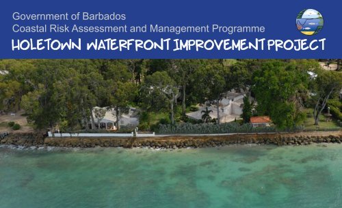
Government of Barbados<br />
<strong>Coastal</strong> Risk Assessment and Management Programme<br />
<strong>Holetown</strong> <strong>Waterfront</strong> <strong>Improvement</strong> <strong>Project</strong><br />
1
<strong>Holetown</strong> <strong>Waterfront</strong> <strong>Improvement</strong> <strong>Project</strong><br />
Copyright © 2012 by <strong>Coastal</strong> <strong>Zone</strong> Management Unit<br />
All rights reserved. No part of this book may be reproduced in any form by any electronic or<br />
mechanical means including photocopying, recording, or information storage and retrieval<br />
without permission in writing from the author.<br />
Photo credits<br />
<strong>Coastal</strong> <strong>Zone</strong> Management Unit<br />
W.F. Baird and Associates <strong>Coastal</strong> Engineers Ltd.<br />
Cover photos and Design by<br />
<strong>Coastal</strong> <strong>Zone</strong> Management Unit<br />
Architectural renderings<br />
www.coastal.gov.bb<br />
T:(246)228.5950/1/2<br />
F:(246)228.5956<br />
info@coastal.gov.bb<br />
Printed in Barbados<br />
W.F. Baird and Associates <strong>Coastal</strong> Engineers Ltd.<br />
Text References<br />
Barbados West Coast Beach & Reef - Design <strong>Brief</strong><br />
Prepared by: W.F. Baird and Associates <strong>Coastal</strong> Engineers Ltd.<br />
Prepared for: Government of Barbados, <strong>Coastal</strong> <strong>Zone</strong> Management Unit
Programme overview<br />
The principle objective of the Programme is to ensure a healthy environment and<br />
continued economic development of Barbados through improved management<br />
and conservation of the coastal zone.<br />
The Programme comprises a range of coastal management works and activities<br />
related to four specific objectives:<br />
• Shoreline stabilization and erosion control;<br />
• Restoration of coastal habitats;<br />
• <strong>Improvement</strong> of public coastal access and<br />
• Institutional strengthening for coastal management.<br />
Programme Background<br />
The 92 km. long Barbados coastline has an interesting diversity of land and<br />
seascapes and is a unique asset. The coastline of Barbados is central to the<br />
lives of all Barbadians, providing amenities that go well beyond those traditionally<br />
valued by the market. The beaches of Barbados are a focus for leisure and<br />
recreational use by locals and visitors. Tourism has provided the backbone for<br />
Barbados’ economic progress in the last 40 years. It remains one of the largest<br />
growth industries in the world and continued benefit to Barbados is dependent<br />
on the provision to visitors of an acceptable natural and built environment. There<br />
are few parts of Barbados where the hand of human intervention has failed to<br />
leave a mark on the natural environment. Development has resulted in coastlines<br />
dominated by tourism and luxury residential infrastructure. Impacts of development<br />
on the coastal environment include loss of natural habitat, encroachment on<br />
active beach areas, poor water quality, and lowered reef health. A fragmented<br />
institutional and legislative structure historically restricted the Government of<br />
Barbados’ s (GoB’s) capacity to respond to these problems. The value of beaches<br />
and the pressure of use on them make it essential to manage the resource in<br />
a way that caters for the demand without damaging the resource on which it<br />
depends. To address the growing threats to the coastline of Barbados, in 1983<br />
the Government of Barbados embarked on a programme to prepare Barbados<br />
for coastal zone management in an effort to safeguard the character and special<br />
features of the coastline while recognizing the opportunities these features<br />
create. The GoB’ s efforts have resulted in development and implementation of<br />
a comprehensive approach to manage the environment, resources and use of its<br />
coastline through Integrated <strong>Coastal</strong> Management (ICM).<br />
Between 1983-84, a Diagnostic and Pre-Feasibility Study of the island’s coast<br />
was conducted by the Government of Barbados with financial support from<br />
the Inter-American Development Bank (IADB) and executed by the <strong>Coastal</strong><br />
Conservation <strong>Project</strong> Unit (now the <strong>Coastal</strong> <strong>Zone</strong> Management Unit), which<br />
was established specifically for that purpose. Two further projects were<br />
subsequently supported through pre-investment loans; the <strong>Coastal</strong> Conservation<br />
Pre-Investment Programme (U.S. $4.7 million) and the technical cooperation<br />
<strong>Coastal</strong> Conservation Phase I (U.S. 3.6 million). The <strong>Coastal</strong> Conservation Pre<br />
Investment Programme was carried out in Barbados from 1991 to 1995 and<br />
focused on the west and southwest coasts and designed various engineering and<br />
non-engineering measures for beach creation, stabilization and enhancement.<br />
Pilot projects for beach improvement and protection included the segmented<br />
breakwater at Reads Bay, the berm breakwater at Paynes Bay and the offshore<br />
breakwater and groyne at Rockley (Appendix VII). Another product of this program<br />
was the preliminary designs and cost estimates for recommended shoreline<br />
and beach enhancement projects. These proposed projects were developed to<br />
improve environmental quality, provide for shore protection and provide improved<br />
beach recreation conditions. The programme also undertook the preparation of<br />
two draft Bills for submission to Parliament – the draft <strong>Coastal</strong> <strong>Zone</strong> Management<br />
Act and the Marine Pollution Control Act (Both of which were passed in December<br />
1998).<br />
During the period from 1997 to 1999 the GoB sought further assistance from the<br />
IADB in financing the first phase of a comprehensive island–wide coastal zone<br />
management programme, The <strong>Coastal</strong> Conservation Programme Phase I. This<br />
Technical Cooperation focused primarily on diagnostic studies for Atlantic coast.<br />
A number of coastal projects, the Rockley to Sierra Beach being the largest and<br />
most complex on the South coast, as well as projects at Tent Bay and the Crane<br />
Beach, were proposed for the east and southeast coasts. Outline conceptual<br />
designs and preliminary cost estimates were prepared for most of these proposed<br />
coastal works. Also, the projects proposed in1991 1995 for the west and southwest<br />
coasts were reviewed and, in some cases, modified. Cost estimates were also<br />
prepared for these updated, though still preliminary projects. The Technical<br />
Proposal also prepared a detailed <strong>Coastal</strong> <strong>Zone</strong> Management Plan for the entire<br />
island, provided support to institutional strengthening efforts and identified cost<br />
recovery mechanisms necessary for financing coastal management projects in<br />
Barbados. These projects for shoreline and beach enhancement are essential<br />
for maintaining the quality of the coastal environment, which in turn provides the<br />
basis for viable and sustained tourism and consequently the continued economic<br />
development of Barbados.<br />
From 2002-2010 the Government executed a coastal infrastructure project to<br />
design and build the projects recommended out of the 1996-1999 project. This<br />
resulted in the erection of<br />
1- The Rockley to Hastings Boardwalk<br />
2- The shoreline enhancement at Welches Beach<br />
3- The <strong>Holetown</strong> accessway<br />
These projects have focused primarily on (1) the creation of continuous lateral<br />
access along sections of the coastline where it was difficult to traverse in the<br />
past; (2) the enhancement of beaches and erection of new beach spaces; (3) the<br />
protection of coastal infrastructure; (4) the integration of climate change adaptation<br />
considerations into coastal engineering design (5) The improvement of coastal<br />
areas and recreational spaces, and (6) The creation of new or reestablishment of<br />
coastal habitat.<br />
4<br />
5
protecting <strong>Holetown</strong><br />
During 2006 a group of stakeholders, comprised primarily of the hotels along<br />
the West coast, requested that a study be completed to assess the present<br />
conditions of the shoreline and develop a plan for improvements to the<br />
beaches in the area. This study covered the area from immediately north<br />
of the <strong>Holetown</strong> <strong>Coastal</strong> Infrastructure <strong>Project</strong> through Discovery Bay and<br />
Folkestone to Heron Bay in the north.<br />
There was a consensus among the stakeholders that the extent of<br />
the beach has decreased in recent years and that the deteriorating<br />
beaches have impacted, and will continue to impact their businesses. The<br />
winter north and south swells that occur along this coast can move sand from<br />
one end of the bay to the other, leaving behind a shoreline that is somewhat<br />
stripped of sand.<br />
The goal of the study was to assess measures that can be taken to improve<br />
the shoreline, while also considering the health of the nearshore reefs and<br />
how these may influence the beaches and shoreline.<br />
© BAIRD<br />
Above: Erosion at Coral Reef Club after a swell event<br />
Right: Nearshore currents for 2.5 m, 14 s NNW waves (left); and physical to-scale<br />
modelling of the proposed structures (right) at Discovery Bay.<br />
current monitoring in project area influenced designs<br />
physical modelling is always recommended for large<br />
scale nbearshore work<br />
6 7<br />
© CZMU
Study area 1983<br />
Study area 2006<br />
Coastline comparisons compliments W. F. Baird<br />
and Associates <strong>Coastal</strong> Engineers LTD.<br />
© BAIRD 8 © BAIRD 9
Engineering Solutions<br />
11 Groynes<br />
2 headlands<br />
5 offshore breakwaters<br />
1 concrete walkway with 2 pocket beaches<br />
10 11
Northern Reach<br />
This image shows preliminary engineering works already completed at Coral Reef Club.<br />
Preliminary works have been implemented at Zaccios, Sand Piper Hotel, Coral Reef Hotel and Colony Club Hotel to help retain the beach during typical southerly<br />
events. It is proposed that North Groyne 4 (NG4) will be installed just to the south of Heron Bay Road. Two groynes will be built in the area of Heron Bay House.<br />
The only other structure that is proposed in this area is a system to assist in managing the drain outlet between Colony Club and Coral Reef Club. This will include<br />
the ability to pump water through a pipe under the beach for water level control, and a higher elevation fluidizer for breaching the top portion of the beach. Designs for<br />
this system are pending.<br />
Artistic rendering of accessway fronting Folkestone and Bellairs<br />
12 13<br />
© BAIRD
Folkestone walkway<br />
The present condition of Folkstone Park is a revetment in poor condition, which has varied amount of sand cover, depending on the wave conditions. Due to the<br />
exposed nature of the site, creation of a wider beach in front of the park would be extremely difficult. However, installation of two pocket beaches in the park may be<br />
possible, providing a more consistent sandy beach and safer water access points in the park. The proposed pocket beaches would be created by excavating into the<br />
land at two locations: in the northern quarter of the park; and in the southern third of the park.<br />
These pocket beaches would have small headlands at each end of the beach, which would help to contain the sand in these locations. The beaches would be<br />
positioned in such a way as to minimize impacts on trees. A walkway would extend through the park on the landward side of these beaches.<br />
© BAIRD<br />
Artistic rendering of one of Folkestone’s pocket beaches to be constructed<br />
14 15
southern Reach<br />
The beach has been improved in the area of Settlers Beach with two 25 m groynes and beachfill. Offshore breakwaters were considered in this area, but were<br />
determined to be optional. The structures in this area will retain larger amounts of sand following the less common south events, but should also provide better<br />
beaches during/following the northern events, particularly adjacent to the structures.<br />
At the next property to the south, The Sandpiper, there is no walkway, but instead there is an improved beach. In addition to the 25 m groyne near the Settlers Beach<br />
/ Sandpiper property line, there is also a groyne near the south end of the property and an offshore reef. The offshore breakwater has a crest elevation of about –0.3<br />
m. These structures will improve the beach for the Sandpiper and the property to the south, and will improve access along a stretch of shoreline that has frequent<br />
problems today. Recent swells in February 2010 have caused further damage to the Sandpiper waterfront<br />
16 17
© BAIRD<br />
© BAIRD<br />
© BAIRD<br />
© BAIRD<br />
3D renders of the proposed headland in <strong>Holetown</strong> south by the <strong>Holetown</strong> Police Station complex. A concrete lateral<br />
access walkway will start here and head North<br />
Properties in Church Point Area will have added protection by a new boulder revetment and<br />
concrete walkway built in front of existing structures wherever possible with access to properties maintained<br />
18 19
The <strong>Coastal</strong> <strong>Zone</strong> Management Unit continues to work to ensure<br />
equitable and sustainable use of the coastline for all stakeholders.<br />
Barbados’ beaches are one of its greatest public assets and it deserves<br />
to be experienced by all, with full and convenient access.<br />
Likewise, the CZMU takes coastal protection and disaster reduction<br />
very seriously. In every part of our work (research, development<br />
planning, beach monitoring/profiling, coastal engineering etc.) there<br />
is significant consideration given to various natural and engineering<br />
solutions to make this small island and its coastal assets more resilient<br />
to disaster, particular with the growing threat of climate change and<br />
sea level rise, and the ever imminent threat of tsunamis.<br />
• Offshore breakwaters will provide precious new benthic habitat for<br />
corals and fishes. Corals and coral-grazing fish (among other factors)<br />
are critical for sand production;<br />
<strong>Improvement</strong>s in the <strong>Holetown</strong> project are expected to take 18 months to<br />
complete with most of the work done during the tourism low-season. During<br />
this construction time naturally there will be some inconveniences. The<br />
project team has and will continue to liaise with stakeholders to minimize<br />
disruption to business, home owners and beach accesses during this time.<br />
The CZMU, on behalf of consultant contractors and engineers as well,<br />
sincerely apologises for any inconvenience caused. The benefits greatly<br />
out-weigh the short term costs.<br />
The <strong>Holetown</strong> <strong>Waterfront</strong> <strong>Improvement</strong> project will bring significant<br />
benefits. Through this project the <strong>Holetown</strong> area will:<br />
• Be more resilient to storm surge waves (hurricanes and winter<br />
swell events);<br />
• Have more stable beaches with less drastic winter<br />
erosion and quicker recovery;<br />
• Beach users will have more convenient lateral access along the<br />
beach, particularly during erosion events;<br />
Economic, Social and Natural Protection<br />
looking at the big picture<br />
© BAIRD © BAIRD<br />
“A Coast to be proud of!”<br />
20 21
<strong>Coastal</strong> <strong>Zone</strong> Management Unit<br />
Bay Street<br />
St. Michael<br />
Barbados 11156<br />
Tel - (246) 228.5950/51/52<br />
Fax - (246) 228.5956<br />
www.coastal.gov.bb<br />
www.czmedia.org<br />
22