A4 pdf version - Edinburgh Geological Society
A4 pdf version - Edinburgh Geological Society
A4 pdf version - Edinburgh Geological Society

Create successful ePaper yourself
Turn your PDF publications into a flip-book with our unique Google optimized e-Paper software.
1<br />
3<br />
6<br />
A<br />
2<br />
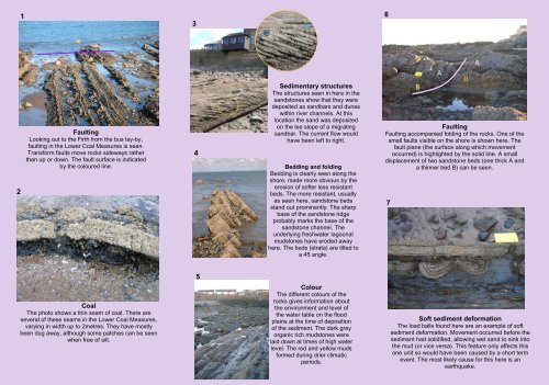
Faulting<br />
Looking out to the Firth from the bus lay-by,<br />
faulting in the Lower Coal Measures is seen.<br />
Transform faults move rocks sideways rather<br />
than up or down. The fault surface is indicated<br />
by the coloured line.<br />
4<br />
Sedimentary structures<br />
The structures seen in here in the<br />
sandstones show that they were<br />
deposited as sandbars and dunes<br />
within river channels. At this<br />
location the sand was deposited<br />
on the lee slope of a migrating<br />
sandbar. The current flow would<br />
have been left to right.<br />
Bedding and folding<br />
Bedding is clearly seen along the<br />
shore, made more obvious by the<br />
erosion of softer less resistant<br />
beds. The more resistant, usually<br />
as seen here, sandstone beds<br />
stand out prominently. The sharp<br />
base of the sandstone ridge<br />
probably marks the base of the<br />
sandstone channel. The<br />
underlying freshwater lagoonal<br />
mudstones have eroded away<br />
here. The beds (strata) are tilted to<br />
a 45 angle.<br />
B<br />
A<br />
Faulting<br />
Faulting accompanied folding of the rocks. One of the<br />
small faults visible on the shore is shown here. The<br />
fault plane (the surface along which movement<br />
occurred) is highlighted by the solid line. A small<br />
displacement of two sandstone beds (one thick A and<br />
a thinner bed B) can be seen.<br />
7<br />
B<br />
5<br />
Coal<br />
The photo shows a thin seam of coal. There are<br />
several of these seams in the Lower Coal Measures,<br />
varying in width up to 2metres. They have mostly<br />
been dug away, although some patches can be seen<br />
when free of silt.<br />
Colour<br />
The different colours of the<br />
rocks gives information about<br />
the environment and level of<br />
the water table on the flood<br />
plains at the time of deposition<br />
of the sediment. The dark grey<br />
organic rich mudstones were<br />
laid down at times of high water<br />
level. The red and yellow muds<br />
formed during drier climatic<br />
periods.<br />
Soft sediment deformation<br />
The load balls found here are an example of soft<br />
sediment deformation. Movement occurred before the<br />
sediment had solidified, allowing wet sand to sink into<br />
the mud (or vice versa). This feature only affects this<br />
one unit so would have been caused by a short term<br />
event. The most likely cause for this here is an<br />
earthquake.