A4 pdf version - Edinburgh Geological Society
A4 pdf version - Edinburgh Geological Society
A4 pdf version - Edinburgh Geological Society

You also want an ePaper? Increase the reach of your titles
YUMPU automatically turns print PDFs into web optimized ePapers that Google loves.
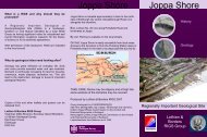
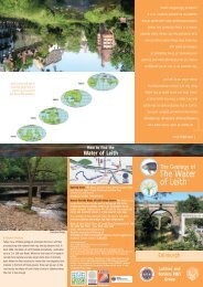
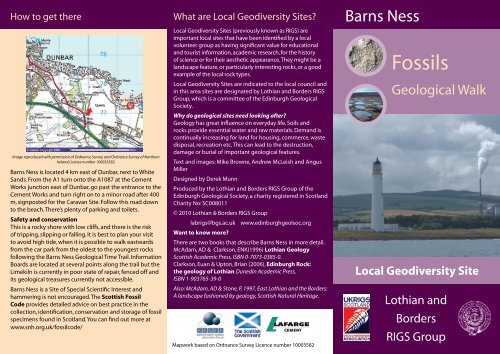
How to get there<br />
Image reproduced with permission of Ordnance Survey and Ordnance Survey of Northern<br />
Ireland.Licence number 100033582.<br />
Barns Ness is located 4 km east of Dunbar, next to White<br />
Sands. From the A1 turn onto the A1087 at the Cement<br />
Works junction east of Dunbar, go past the entrance to the<br />
Cement Works and turn right on to a minor road after 400<br />
m, signposted for the Caravan Site. Follow this road down<br />
to the beach. There’s plenty of parking and toilets.<br />
Safety and conservation<br />
This is a rocky shore with low cliffs, and there is the risk<br />
of tripping, slipping or falling. It is best to plan your visit<br />
to avoid high tide, when it is possible to walk eastwards<br />
from the car park from the oldest to the youngest rocks<br />
following the Barns Ness <strong>Geological</strong> Time Trail. Information<br />
Boards are located at several points along the trail but the<br />
Limekiln is currently in poor state of repair, fenced off and<br />
its geological treasures currently not accessible.<br />
Barns Ness is a Site of Special Scientific Interest and<br />
hammering is not encouraged. The Scottish Fossil<br />
Code provides detailed advice on best practice in the<br />
collection, identification, conservation and storage of fossil<br />
specimens found in Scotland. You can find out more at<br />
www.snh.org.uk/fossilcode/<br />
What are Local Geodiversity Sites<br />
Local Geodiversity Sites (previously known as RIGS) are<br />
important local sites that have been identified by a local<br />
volunteer group as having significant value for educational<br />
and tourist information, academic research, for the history<br />
of science or for their aesthetic appearance. They might be a<br />
landscape feature, or particularly interesting rocks, or a good<br />
example of the local rock types.<br />
Local Geodiversity Sites are indicated to the local council and<br />
in this area sites are designated by Lothian and Borders RIGS<br />
Group, which is a committee of the <strong>Edinburgh</strong> <strong>Geological</strong><br />
<strong>Society</strong>.<br />
Why do geological sites need looking after<br />
Geology has great influence on everyday life. Soils and<br />
rocks provide essential water and raw materials. Demand is<br />
continually increasing for land for housing, commerce, waste<br />
disposal, recreation etc. This can lead to the destruction,<br />
damage or burial of important geological features.<br />
Text and images: Mike Browne, Andrew McLeish and Angus<br />
Miller<br />
Designed by Derek Munn<br />
Produced by the Lothian and Borders RIGS Group of the<br />
<strong>Edinburgh</strong> <strong>Geological</strong> <strong>Society</strong>, a charity registered in Scotland<br />
Charity No: SC008011<br />
© 2010 Lothian & Borders RIGS Group<br />
labrigs@bgs.ac.uk<br />
Want to know more<br />
www.edinburghgeolsoc.org<br />
There are two books that describe Barns Ness in more detail.<br />
McAdam, AD & Clarkson, ENK(1996) Lothian Geology<br />
Scottish Academic Press, ISBN 0-7073-0385-0.<br />
Clarkson, Euan & Upton, Brian (2006), <strong>Edinburgh</strong> Rock:<br />
the geology of Lothian Dunedin Academic Press,<br />
ISBN 1-903765-39-0<br />
Also: McAdam, AD & Stone, P, 1997, East Lothian and the Borders:<br />
A landscape fashioned by geology, Scottish Natural Heritage.<br />
Mapwork based on Ordnance Survey Licence number 10003582<br />
Barns Ness<br />
Fossils<br />
<strong>Geological</strong> Walk<br />
Local Geodiversity Site<br />
Lothian and<br />
Borders<br />
RIGS Group
What’s so special about Barns Ness<br />
This short walk along the shore from White Sands to the<br />
Barns Ness lighthouse allows you to discover the most<br />
extensive limestone outcrops in central Scotland. There<br />
are also other sedimentary rocks including sandstone,<br />
mudstone and coal, and plenty of fossils.<br />
Barns Ness Fossils<br />
Barns Ness is a great place to find fossils, the remains of<br />
the life that thrived in tropical seas 320 million years ago.<br />
At Barns Ness you can see body fossils - the remains of<br />
the actual animal or plant, and trace fossils which are the<br />
remains of the burrows or trails left by an animal.<br />
Body fossil: Colonial coral Siphonodendron<br />
Body fossil: Solitary coral<br />
From McAdam & Stone, 1997, East Lothian and the Borders: A<br />
landscape fashioned by geology<br />
The rocks are over 320 million years old (the<br />
Carboniferous Period) and were laid down as soft<br />
sediment when Scotland was located just south of the<br />
Equator, and the climate was tropical, both hot and wet.<br />
Sea level kept rising and falling, so that at times this area<br />
was under shallow sea water, and at other times it was a<br />
flat coastal plain.<br />
The sea level changes were caused by subsidence of this<br />
area and changing global sea-levels due to ice ages.<br />
The abundant corals in the limestones indicate that they<br />
lived in tropical, warm, shallow, clear seawater. However<br />
rivers were flowing from the mountains to the north;<br />
they brought mud and sand to silt up the shallow sea<br />
and reclaim the land, producing muddy coastal swamps<br />
and deltas with low-lying sandbanks and river channels.<br />
Eventually this new land was colonised by lycopod<br />
forests (similar to mangrove swamps in the world today).<br />
Later, the land would subside once more or global sealevel<br />
would rise, drowning the forest and starting a new<br />
sediment cycle.<br />
Trace fossil: Zoophycos (burrow)<br />
Trace fossil: Rhizocorallium (burrow) – left of pen<br />
Body fossil: Crinoid Parazeacrinites sea lily<br />
Trace fossil: Thalassinoides (burrow)
Stop 1: Limestone and sandstone<br />
The limestone forms a prominent platform extending<br />
from the east end of White Sands. The rock is creamy<br />
white in colour, and looks lumpy. It is full of fossils<br />
including colonial corals that look like spaghetti, large<br />
solitary corals, brachiopod shells, and crinoids.<br />
The importance of limestone<br />
Barns Ness is a good place to appreciate the<br />
agricultural and economic importance of limestone.<br />
The lime kiln at the back of the beach was one<br />
of many in the Lothians, where layers of coal<br />
and limestone were burnt to create quicklime for<br />
agriculture. This was a dangerous and labourintensive<br />
process, but proved its worth in increased<br />
crop yields.<br />
In the distance to the south, you can see the tower and<br />
chimney of Dunbar Cement works, which processes<br />
local limestone and mudstone to produce cement. This<br />
is the only cement works in Scotland with the capacity<br />
to produce one million tonnes of cement a year.<br />
From McAdam and Clarkson, 1996, Lothian Geology.<br />
Beneath the limestone is a layer of dark brown<br />
sandstone. It contains trace fossils; both U-shaped tubes<br />
and Zoophycos ‘cocks tails’. These features are the result<br />
of unknown animals searching for shelter or food just<br />
under the seabed, before the sand was converted to<br />
rock.<br />
Walk along the top of the limestone. You may spot<br />
parallel scratches on the rock surface caused by rock<br />
moving against rock during an earthquake. The yellow<br />
colour of the limestone is due to small amounts of iron.
Stops 2 - 6<br />
Stop 2: old jetty and limekiln<br />
Stop 4: coal seam<br />
and fossil mudstone<br />
In the small cliff above high<br />
tide you can find a thin coal<br />
seam overlying the grey<br />
seatearth. Above the coal<br />
is a layer of mudstone with<br />
lots of fossil shells including<br />
Eomarginifera and the<br />
bivalve Streblopteria, along<br />
with crinoid debris. The top<br />
layer is another limestone.<br />
Stop 6: Decorative Dunbar Marble<br />
Walk along the pebble beach to the rocks at the far<br />
end, and search for a bed full of solitary corals, called<br />
Koninckophyllum. What unusual conditions gave rise to<br />
this amazing death assemblage is not known; did they<br />
all die in a storm Over 100 years ago, this attractive but<br />
relatively soft stone was quarried as a decorative marble<br />
for fireplaces.<br />
The jetty is on the shore a short distance west of<br />
the limekiln. There is a curious layer on top of the<br />
limestone here, which looks quite solid, and contains<br />
shells and sand just like layers in other parts of<br />
Scotland that formed when the sea level was high after<br />
the last ice age. Look closely however and you’ll find<br />
bricks and other human debris.<br />
Stop 3: Hollows in limestone<br />
This extensive area of basin shaped hollows, each<br />
about one metre across, is the most impressive<br />
geological feature of this trail. Look closely in the<br />
hollows and you’ll find some are partly filled by a grey<br />
rock called “seatearth”. This is a fossil wetland soil, full<br />
of preserved roots. The hollows are an original feature<br />
of the limestone, perhaps formed when the sea<br />
receded to expose the top of the<br />
limestone allowing<br />
a forest to<br />
grow on the<br />
newly exposed<br />
land. Perhaps<br />
each pothole is<br />
the location of<br />
the roots of an<br />
individual tree.<br />
Stop 5: Fault line<br />
When the tide is low, a discontinuous wall of limestone<br />
runs out to sea. This marks the position of a small fault<br />
line. Along the fault some of the limestone has converted<br />
to dolostone that resists weathering better than the<br />
unaltered limestone. You can find some good crystals of<br />
dolomite along the fault.<br />
Because the dolostone forms a wall, it has been<br />
previously confused as a dyke of igneous rock.<br />
Proceed around the small headland of lumpy limestone<br />
and look out for rare fossils called Chaetetes. This is a<br />
demosponge and was a common reef-building organism<br />
of the Carboniferous. Look closely and you can see tiny<br />
holes similar to a bath sponge.