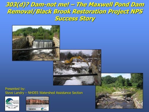
The Maxwell Pond Dam Removal/Black Brook ... - NEIWPCC
The Maxwell Pond Dam Removal/Black Brook ... - NEIWPCC
The Maxwell Pond Dam Removal/Black Brook ... - NEIWPCC

Create successful ePaper yourself
Turn your PDF publications into a flip-book with our unique Google optimized e-Paper software.
303(d) <strong>Dam</strong>-not me! – <strong>The</strong> <strong>Maxwell</strong> <strong>Pond</strong> <strong>Dam</strong><br />
<strong>Removal</strong>/<strong>Black</strong> <strong>Brook</strong> Restoration Project NPS<br />
Success Story<br />
Presented by:<br />
Steve Landry – NHDES Watershed Assistance Section
Gulf of Maine Watershed Locus Map<br />
YOU ARE HERE<br />
Portsmouth, NH<br />
<strong>Maxwell</strong> <strong>Pond</strong><br />
<strong>Dam</strong><br />
Manchester, NH<br />
Merrimack, NH<br />
Atlantic Ocean<br />
Merrimack River<br />
Nashua, NH<br />
Lawrence, MA<br />
Lowell, MA
<strong>Maxwell</strong> <strong>Pond</strong> <strong>Dam</strong>
22.25 sq miles
<strong>Maxwell</strong> <strong>Pond</strong> <strong>Dam</strong> - 1900
Front Street<br />
Ice House - 1952
Safety – Administrative Order from DES <strong>Dam</strong> Bureau.<br />
Economics – About $1 million to dredge and repair or $40K to<br />
remove and restore <strong>Black</strong> <strong>Brook</strong>.<br />
Flooding – Front street was destroyed and local businesses were<br />
Evacuated in 2006 and 2007. Utility infrastructure was compromised.<br />
Restoration of impaired waters – <strong>Maxwell</strong> <strong>Pond</strong> was on the 303(d)<br />
list of impaired waters since 2004 for failure to support aquatic life<br />
use due to insufficient dissolved oxygen.
Water, water, everywhere, and not a drop to breathe!
Sweet!!<br />
Yea!
If you “un-build” it, they will come…
Summer 2008
Drawdown – September 2008
February 24 th 2009 Morning
March 9 th 2009
March 10 th 2009 - Morning
March 24 th 2009
June 29 th 2009
July 27 , 2010
September 29, 2011
March 6, 2012
April 13, 2012
Lost & Found
Pre- and Post- Monitoring at MPD
Pre- and Post- Monitoring at MPD
Streambed Particle Size Analyses
Upstream<br />
Reference<br />
X-Section “L”
X-Section “H”<br />
(<strong>Maxwell</strong> <strong>Pond</strong>)
Vegetation Community Surveys
Longitudinal and Cross Section<br />
Surveys
Reference Reach (<strong>Black</strong> <strong>Brook</strong>)
Former Impoundment (<strong>Maxwell</strong> <strong>Pond</strong>)
Fish Population Surveys
<strong>Black</strong> <strong>Brook</strong> Fish Population Surveys 2002 – 2010<br />
<strong>Dam</strong> <strong>Removal</strong><br />
300<br />
250<br />
287<br />
Downstream of <strong>Dam</strong> & Former Impoundment<br />
200<br />
150<br />
100<br />
134<br />
194<br />
50<br />
0<br />
61<br />
15 17 48 14 15 10<br />
2002 2008 Jun-09 Aug-09 2010<br />
Total Fish<br />
Total Species
<strong>Black</strong> <strong>Brook</strong> Fish Population Surveys 2002 – 2010<br />
<strong>Dam</strong> <strong>Removal</strong><br />
300<br />
250<br />
Upstream of Former Impoundment (Reference Reach)<br />
256<br />
200<br />
220<br />
150<br />
156<br />
100<br />
50<br />
0<br />
7 9 8<br />
2002 2008 2010<br />
Total Fish<br />
Total Species
<strong>Black</strong> <strong>Brook</strong> Fish Population Surveys 2002 – 2010<br />
120<br />
100<br />
80<br />
60<br />
40<br />
Within Former Impoundment<br />
99<br />
109<br />
20<br />
0<br />
19<br />
8 9<br />
4<br />
2009 (June) 2009 (August) 2010<br />
Total Fish<br />
Total Species
<strong>Black</strong> <strong>Brook</strong> is the<br />
farthest upstream in the<br />
entire Merrimack River<br />
basin that I have been<br />
found!<br />
Free Fish!<br />
I’m on the State<br />
Threatened list<br />
I’m a species of<br />
concern in New<br />
England<br />
I’m a host species for state<br />
endangered brook floater as<br />
well as state/federal<br />
endangered dwarf wedge<br />
mussels<br />
I was from the hatchery<br />
and looking for thermal<br />
refuge in <strong>Black</strong> <strong>Brook</strong>
Aquatic Macroinvertebrate<br />
Community Surveys
Number of Major Groups<br />
<strong>Dam</strong> <strong>Removal</strong><br />
7<br />
6<br />
<strong>Black</strong> <strong>Brook</strong> Aquatic Macroinvertebrate Surveys<br />
2002 – 2011<br />
Downstream of <strong>Dam</strong> & Former Impoundment<br />
38<br />
5<br />
4<br />
3<br />
24<br />
31<br />
34<br />
38 38<br />
2<br />
29<br />
1<br />
0<br />
2002 (May) 2002 (Jul) 2003 (Jun) 2006 (Sep) 2008 (Sep) 2010 (Oct) 2011 (Nov)<br />
Senstive Somewhat Sensitive Tolerant
Number of Major Groups<br />
<strong>Dam</strong> <strong>Removal</strong><br />
7<br />
6<br />
<strong>Black</strong> <strong>Brook</strong> Aquatic Macroinvertebrate Surveys<br />
2002 – 2011<br />
Upstream of Former Impoundment<br />
49<br />
5<br />
4<br />
37<br />
3<br />
26<br />
41<br />
22<br />
2<br />
1<br />
0<br />
20<br />
2002 (May) 2003 (Jun) 2006 (Sep) 2008 (Sept) 2010 (Oct) 2011 (Nov)<br />
Senstive Somewhat Sensitive Tolerant
Number of Major Groups<br />
7<br />
6<br />
5<br />
<strong>Black</strong> <strong>Brook</strong> Aquatic Macroinvertebrate Surveys<br />
2002 – 2011<br />
Within Former Impoundment<br />
43 36<br />
4<br />
3<br />
2<br />
1<br />
0<br />
2010 (Oct) 2011 (Nov)<br />
Senstive Somewhat Sensitive Tolerant
Monumented Photo Points
Water Quality
7/5/2000<br />
10/5/2000<br />
1/5/2001<br />
4/5/2001<br />
7/5/2001<br />
10/5/2001<br />
1/5/2002<br />
4/5/2002<br />
7/5/2002<br />
10/5/2002<br />
1/5/2003<br />
4/5/2003<br />
7/5/2003<br />
10/5/2003<br />
1/5/2004<br />
4/5/2004<br />
7/5/2004<br />
10/5/2004<br />
1/5/2005<br />
4/5/2005<br />
7/5/2005<br />
10/5/2005<br />
1/5/2006<br />
4/5/2006<br />
7/5/2006<br />
10/5/2006<br />
1/5/2007<br />
4/5/2007<br />
7/5/2007<br />
10/5/2007<br />
1/5/2008<br />
4/5/2008<br />
7/5/2008<br />
10/5/2008<br />
1/5/2009<br />
4/5/2009<br />
7/5/2009<br />
10/5/2009<br />
1/5/2010<br />
4/5/2010<br />
7/5/2010<br />
10/5/2010<br />
1/5/2011<br />
4/5/2011<br />
7/5/2011<br />
<strong>Dam</strong> <strong>Removal</strong> (February 2009)<br />
100<br />
Average =75%<br />
80<br />
75<br />
60<br />
Average =89%<br />
40<br />
20<br />
Average =5.53 mg/L<br />
Average =8.15 mg/L<br />
5<br />
0<br />
D.O. (mg/L) D.O. Sat (%) NH WQ Standard (mg/L) NH WQ Standard (%)
Fish
That was then…<br />
This is now…
Thanks for the<br />
fish passage!<br />
Thanks for<br />
the snacks!<br />
Thanks for the<br />
oxygen!<br />
Steve Landry, Merrimack Watershed<br />
Supervisor<br />
NHDES – Watershed Assistance Section<br />
(603) 271-2969<br />
stephen.landry@des.nh.gov