Geophysics for the irrigation industry - National Program for ...
Geophysics for the irrigation industry - National Program for ...
Geophysics for the irrigation industry - National Program for ...
Create successful ePaper yourself
Turn your PDF publications into a flip-book with our unique Google optimized e-Paper software.
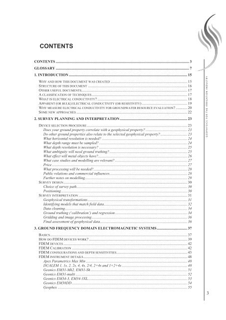
CONTENTS<br />
CONTENTS ............................................................................................................................................. 3<br />
GLOSSARY ............................................................................................................................................. 7<br />
1. INTRODUCTION ............................................................................................................................. 15<br />
WHY AND HOW THIS DOCUMENT WAS CREATED ................................................................................. 15<br />
STRUCTURE OF THIS DOCUMENT ......................................................................................................... 16<br />
OTHER USEFUL DOCUMENTS................................................................................................................ 17<br />
A CLASSIFICATION OF TECHNIQUES..................................................................................................... 17<br />
WHAT IS ELECTRICAL CONDUCTIVITY ............................................................................................... 18<br />
APPARENT (OR BULK) ELECTRICAL CONDUCTIVITY (OR RESISTIVITY) ................................................ 19<br />
WHY MEASURE ELECTRICAL CONDUCTIVITY FOR GROUNDWATER RESOURCE EVALUATION ............ 20<br />
SOME NEW APPROACHES ..................................................................................................................... 22<br />
2. SURVEY PLANNING AND INTERPRETATION ....................................................................... 23<br />
DEVICE SELECTION PROCEDURE.......................................................................................................... 23<br />
Does your ground property correlate with a geophysical property............................................ 23<br />
Do o<strong>the</strong>r ground properties also relate to <strong>the</strong> selected geophysical property ............................ 23<br />
What horizontal resolution is needed .......................................................................................... 24<br />
What depth range must be sampled ............................................................................................. 24<br />
What depth resolution is necessary .............................................................................................25<br />
What ambiguity will need ground truthing.................................................................................. 25<br />
What effect will metal objects have.............................................................................................. 26<br />
What case studies and modelling are relevant ............................................................................ 27<br />
Price ............................................................................................................................................... 27<br />
What processing will be needed................................................................................................... 28<br />
Public relations and commercial influences.................................................................................. 28<br />
Fur<strong>the</strong>r notes on modelling............................................................................................................ 29<br />
SURVEY DESIGN................................................................................................................................... 30<br />
Choice of survey path..................................................................................................................... 30<br />
Positioning ..................................................................................................................................... 30<br />
SURVEY INTERPRETATION ................................................................................................................... 31<br />
Geophysical trans<strong>for</strong>mations......................................................................................................... 31<br />
Identifying models that match field data........................................................................................32<br />
Data cleaning................................................................................................................................. 34<br />
Ground truthing (‘calibration’) and regression ............................................................................ 34<br />
Gridding and image processing..................................................................................................... 36<br />
Final assessment of geophysical data............................................................................................36<br />
3. GROUND FREQUENCY DOMAIN ELECTROMAGNETIC SYSTEMS................................ 37<br />
BASICS................................................................................................................................................. 37<br />
HOW DO FDEM DEVICES WORK ........................................................................................................ 39<br />
FDEM DEVICES................................................................................................................................... 42<br />
FDEM CALIBRATION .......................................................................................................................... 42<br />
FDEM CONFIGURATIONS AND DEPTH SENSITIVITIES........................................................................... 43<br />
FDEM INSTRUMENT DETAILS.............................................................................................................. 48<br />
Apex Parametrics Max Min ........................................................................................................... 48<br />
DUALEM 1, 1s, 2, 2s, 4, 4s, 2/4, 2+4s and 1+2+4s ..................................................................... 48<br />
Geonics EM31-Mk2, EM31-Sh ...................................................................................................... 51<br />
Geonics EM31-multi ...................................................................................................................... 52<br />
Geonics EM34-3, EM34-3XL......................................................................................................... 53<br />
Geonics EM38DD.......................................................................................................................... 54<br />
Geophex ......................................................................................................................................... 55<br />
GEOPHYSICS FOR THE IRRIGATION INDUSTRY<br />
3


