Paleozoic rocks north of Snake River Plain
Paleozoic rocks north of Snake River Plain
Paleozoic rocks north of Snake River Plain

You also want an ePaper? Increase the reach of your titles
YUMPU automatically turns print PDFs into web optimized ePapers that Google loves.
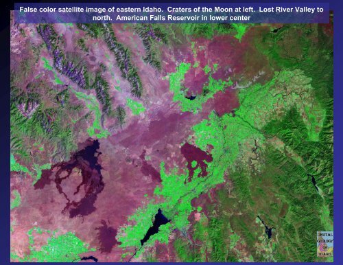
False color satellite image <strong>of</strong> eastern Idaho. Craters <strong>of</strong> the Moon at left. Lost <strong>River</strong> Valley to<br />
<strong>north</strong>. American Falls Reservoir in lower center
Geologic map <strong>of</strong> US from<br />
USGS. Shows thrust belt,<br />
basin and range, and SRP.
Lost <strong>River</strong> and Lemhi Ranges.
Geologic map <strong>of</strong> parts <strong>of</strong> Blaine and Custer Counties Shows cross section from<br />
Batholith east through core complex to thrust belt.
Beaverhead Range, view to <strong>north</strong> from Northern Lemhi Range. Freeman Peak is the<br />
jagged bare peak on the left. Dissected Eocene sediments in foreground.
Upper Pahsimeroi view to south, east side <strong>of</strong> Lost <strong>River</strong> Range. Mt. Breitenbach on<br />
left. Folded Mississippian carbonate <strong>rocks</strong>.
Lemhi Range, Bell Mountain, view to east from Donkey Hills
South end <strong>of</strong> Lemhi Range. <strong>Paleozoic</strong> sediments.
Arco Hills. Folded Snaky Canyon Fm.
Fold in Devonian Grandview Dolomite Northern Lost <strong>River</strong> Range.
Folds in Lost <strong>River</strong> Range. View to south from near Borah.
View west from chicken out ridge <strong>of</strong> Borah. Yellow beds are in Devonian Jefferson<br />
Formation.
Flatirons in Devonian limestones, dipping east, west <strong>of</strong> Borah Peak.
Mississippian limestone in Lost <strong>River</strong> Range. Slope at base is McGowan Canyon Fm.<br />
Cliffs are in Carbonate Bank succession.
Pass Creek, Anticline with cave in middle in Mississippian limestone.
Road up Pass Creek, southern Lost <strong>River</strong> Range, Mississippian limestones
Mt. McCaleb, view east. At base is Devonian carbonates with trees, bare lower Mississippian<br />
talus <strong>of</strong> McGowan Creek Formation, and upper Mississippian limestone on top <strong>of</strong> peak
Empire Copper Mine Open Pit and White Knob Mountains looking <strong>north</strong>west from Leslie. Mackay<br />
hill climb bike track is on the lower right in the snowpatches. This was the old mine access road.
Empire Mine. White Knob Mountains west <strong>of</strong> Mackay. Lost <strong>River</strong> Range in background
Map <strong>of</strong> Central Idaho<br />
<strong>Paleozoic</strong> Black Shale<br />
Mineral Belt.
Folded black carbonaceous argillites <strong>of</strong> Milligen Formation, Boulder Mountains. This<br />
rock was source <strong>of</strong> silver-lead-zinc deposits near Hailey
Buttercup Mine, Smoky Mountains. Permian Dollarhide Formation
Scalarituba trace fossil. Wood <strong>River</strong> Fm.
Contorted bedding in silty turbidites. Wilson Creek Member Wood <strong>River</strong> Fm.
Minnie Moore Mine, view west from above Belleview.
Triumph mine Pioneer Mountains.
Triumph mine portal. Acid mine drainage.