Discovery Report - Ohio Department of Natural Resources
Discovery Report - Ohio Department of Natural Resources
Discovery Report - Ohio Department of Natural Resources

You also want an ePaper? Increase the reach of your titles
YUMPU automatically turns print PDFs into web optimized ePapers that Google loves.
<strong>Discovery</strong> <strong>Report</strong><br />
FEMA Region V<br />
Auglaize River Watershed, <strong>Ohio</strong><br />
HUC 04100007<br />
Prepared by<br />
i<br />
Auglaize River Watershed <strong>Discovery</strong> <strong>Report</strong>, June 2011
Project Area Community List<br />
Community Name<br />
<strong>Ohio</strong><br />
Ada, City <strong>of</strong> 390251 Henry County 390776<br />
Allen County 390758 Kalida, Village <strong>of</strong> 390471<br />
Auglaize County 390761 Lafayette, Village <strong>of</strong> 390803<br />
Beaverdam, Village <strong>of</strong> 390955 Latty, Village <strong>of</strong> 39X061<br />
Broughton, Village <strong>of</strong> 39X019 Lima, City <strong>of</strong> 390006<br />
Buckland, Village <strong>of</strong> 390816 Melrose, Village <strong>of</strong> 39X076<br />
Cairo, Village <strong>of</strong> 390801 Mercer County 390392<br />
Cecil, Village <strong>of</strong> 39X023 Middle Point, Village <strong>of</strong> 390841<br />
Cloverdale, Village <strong>of</strong> 39X027 Miller City, Village <strong>of</strong> 39X079<br />
Columbus Grove, Village <strong>of</strong> 390466 Oakwood, Village <strong>of</strong> 390437<br />
Continental, Village <strong>of</strong> 391002 <strong>Ohio</strong> City, Village <strong>of</strong> 390869<br />
Convoy, Village <strong>of</strong> 390550 Ottoville, Village <strong>of</strong> 390473<br />
Cridersville, Village <strong>of</strong> 390729 Paulding County 390777<br />
Defiance County 390143 Paulding, Village <strong>of</strong> 390438<br />
Defiance, City <strong>of</strong> 390144 Payne, Village <strong>of</strong> 390439<br />
Delphos, City <strong>of</strong> 390005 Putnam County 390465<br />
Dupont, Village <strong>of</strong> 390467 Scott, Village <strong>of</strong> 390857<br />
Elgin, Village <strong>of</strong> 39X036 Shelby County 390503<br />
Elida, Village <strong>of</strong> 390656 Spencerville, Village <strong>of</strong> 39X129<br />
Fort Jennings, Village <strong>of</strong> 390468 Uniopolis, Village <strong>of</strong> 39X137<br />
Fort Shawnee, Village <strong>of</strong> 390611 Van Wert, City <strong>of</strong> 390552<br />
Grover Hill, Village <strong>of</strong> 390436 Van Wert County 390784<br />
Hancock County 390767 Venedocia, Village <strong>of</strong> 39X140<br />
Hardin County 390250 Wapakoneta, City <strong>of</strong> 390023<br />
Harrod, Village <strong>of</strong> 390956 Waynesfield, Village <strong>of</strong> 39X142<br />
Haviland, Village <strong>of</strong><br />
39X049<br />
Indiana<br />
Adams County 180424 Monroeville, Town <strong>of</strong> 180498<br />
Allen County 180302<br />
ii<br />
Auglaize River Watershed <strong>Discovery</strong> <strong>Report</strong>, June 2011
iii<br />
Auglaize River Watershed <strong>Discovery</strong> <strong>Report</strong>, June 2011
Table <strong>of</strong> Contents<br />
I. Watershed Description ........................................................................................ 1<br />
II. Project Description and Methodology ................................................................. 4<br />
III. Data Analysis ....................................................................................................... 5<br />
i. Data that can be used for Flood Risk Products .................................................... 7<br />
ii. Other Data and Information ................................................................................. 8<br />
IV. Risk MAP Needs ............................................................................................... 12<br />
i. Floodplain Studies ............................................................................................. 12<br />
ii. Mitigation Projects ............................................................................................. 13<br />
iii. Compliance ........................................................................................................ 13<br />
iv. Communications ................................................................................................ 13<br />
V. Close .................................................................................................................. 13<br />
VI. Appendix and Tables ......................................................................................... 14<br />
iv<br />
Auglaize River Watershed <strong>Discovery</strong> <strong>Report</strong>, June 2011
I. Watershed Description<br />
Region V initiated a <strong>Discovery</strong> project in November 2010 for the Auglaize River<br />
Watershed. The <strong>Discovery</strong> process involved coordination with watershed stakeholder, data<br />
collection and analysis, a meeting with stakeholders in the watershed, and development <strong>of</strong><br />
recommendations for risk map projects based on an analysis <strong>of</strong> data and information<br />
gathered throughout the process.<br />
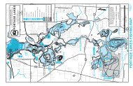
The Auglaize River Watershed is located in northwestern <strong>Ohio</strong>, where the 113 mile long<br />
Auglaize River flows into the Maumee River within the City <strong>of</strong> Defiance. The principal<br />
tributaries to the Auglaize River are Flatrock Creek, Blue Creek, the Little Auglaize River<br />
and the Ottawa River. The headwaters originate in Auglaize and eastern Hardin counties<br />
and flow north through Allen, Putnam, Paulding and Defiance Counties. The watershed<br />
also drains the majority <strong>of</strong> Van Wert, along with small portions <strong>of</strong> Mercer and Henry<br />
Counties in <strong>Ohio</strong> and Allen and Adams Counties in Indiana. Table 1 below includes the<br />
National Flood Insurance Program (NFIP) participation status <strong>of</strong> each County and<br />
Community within the Auglaize River Watershed.<br />
1<br />
Little Miami River Watershed <strong>Discovery</strong> <strong>Report</strong>, DRAFT April 2011
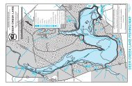
Figure 1: Project Area Map<br />
Table 1. NFIP Participation Status<br />
2<br />
Auglaize River Watershed <strong>Discovery</strong> <strong>Report</strong>, June 2011
County Community Participating<br />
Adams, Indiana<br />
Adams County Yes<br />
Monroeville Yes<br />
Allen, Indiana Allen County Yes<br />
Allen County Yes<br />
Beaverdam No<br />
Cairo<br />
No<br />
Delphos Yes<br />
Allen, <strong>Ohio</strong><br />
Elida<br />
Yes<br />
Fort Shawnee Yes<br />
Harrod<br />
No<br />
Lafayette No<br />
Lima<br />
Yes<br />
Spencerville No<br />
Auglaize County Yes<br />
Buckland Yes<br />
Auglaize, <strong>Ohio</strong><br />
Cridersville No<br />
Uniopolis No<br />
Wapakoneta Yes<br />
Waynesfield No<br />
Defiance, <strong>Ohio</strong><br />
Defiance County Yes<br />
Defiance Yes<br />
Hancock, <strong>Ohio</strong> Hancock County Yes<br />
County Community Participating<br />
Hardin County Yes<br />
Hardin, <strong>Ohio</strong> Ada<br />
No<br />
Kenton<br />
Yes<br />
Henry, <strong>Ohio</strong> Henry County Yes<br />
Mercer, <strong>Ohio</strong> Mercer County Yes<br />
Paulding County Yes<br />
Broughton<br />
No<br />
Cecil<br />
No<br />
Grover Hill Yes<br />
Paulding, <strong>Ohio</strong> Haviland<br />
No<br />
Melrose<br />
No<br />
Oakwood<br />
Yes<br />
Paulding<br />
Yes<br />
Payne<br />
Yes<br />
Putnam County Yes<br />
Cloverdale No<br />
Columbus Grove No<br />
Continental No<br />
Putnam, <strong>Ohio</strong> Dupont<br />
No<br />
Fort Jennings Yes<br />
Kalida<br />
Yes<br />
Miller City No<br />
Ottoville<br />
Yes<br />
Shelby, <strong>Ohio</strong> Shelby County Yes<br />
Van Wert County Yes<br />
Convoy<br />
Yes<br />
Middle Point Yes<br />
Van Wert, <strong>Ohio</strong> <strong>Ohio</strong> City<br />
Yes<br />
Scott<br />
Yes<br />
Van Wert<br />
Yes<br />
Venedocia<br />
No<br />
3<br />
Auglaize River Watershed <strong>Discovery</strong> <strong>Report</strong>, June 2011
II. Project Description and Methodology<br />
<strong>Discovery</strong> is the process <strong>of</strong> data collection, including information exchange between all<br />
governmental levels <strong>of</strong> stakeholders, spatial data presentation, and cooperative discussion<br />
with stakeholders to better understand the area, decide whether a flood risk project is<br />
appropriate, and if so, to collaborate on the project planning in detail. At this time,<br />
<strong>Discovery</strong> processes and requirements are still being defined; however, draft guidance is<br />
available from the draft Appendix I – <strong>Discovery</strong> (fall 2010), the draft Meetings Guidance<br />
for FEMA Personnel (October 2010) and the FY11 <strong>Discovery</strong>, Statement <strong>of</strong> Priorities<br />
(January 2011). In addition, there are several draft tools and templates at various stages <strong>of</strong><br />
completion that were used to support the effort.<br />
Region V initiated a <strong>Discovery</strong> project in February 2011 for the Auglaize Watershed. The<br />
<strong>Discovery</strong> process involved coordination with watershed stakeholders, data collection and<br />
analysis, a meeting with stakeholders in the watershed, and development <strong>of</strong><br />
recommendations for Risk MAP projects based on an analysis <strong>of</strong> data and information<br />
gathered throughout the process.<br />
The initial phase in the <strong>Discovery</strong> process was establishing a Project Team made up <strong>of</strong><br />
local, state, and federal agencies. The Project Team for the Auglaize Watershed included<br />
representatives from:<br />
At the outset <strong>of</strong> the <strong>Discovery</strong> process, a Project Team was established. The Project Team<br />
for the Auglaize River Watershed included representatives from:<br />
• FEMA Region V, Risk Analysis Branch<br />
• FEMA Region V, Floodplain Management and Insurance Branch<br />
• FEMA Region V, Hazard Mitigation Assistance Branch<br />
• <strong>Ohio</strong> <strong>Department</strong> <strong>of</strong> <strong>Natural</strong> <strong>Resources</strong> (ODNR)<br />
• <strong>Ohio</strong> Emergency Management Agency (OEMA)<br />
• STARR Project Manager<br />
Project Team contact information are provided in Appendix A. The Project Team worked<br />
together to compile the stakeholder list for the Auglaize watershed. <strong>Discovery</strong> Meeting<br />
invitations and stakeholder contact list are presented in Appendix B.<br />
STARR coordinated with community <strong>of</strong>ficials and other watershed stakeholders through<br />
written invitations, phone calls and follow-up emails. The coordination included giving<br />
community <strong>of</strong>ficials information about the <strong>Discovery</strong> process. Communities were asked to<br />
identify “Areas <strong>of</strong> Concern” which could be addressed during the <strong>Discovery</strong> Meeting.<br />
The second phase <strong>of</strong> the <strong>Discovery</strong> Project was the collection <strong>of</strong> relevant tabular and<br />
spatial data for all the communities within the watershed. The data was collected through<br />
online resources, Federal and State sources, and interviews with cooperating communities.<br />
The collected data was used to evaluate both previous and current flooding concerns, while<br />
4<br />
Auglaize River Watershed <strong>Discovery</strong> <strong>Report</strong>, June 2011
determining the vital areas requiring mapping needs. Section III., Data Analysis, provides<br />
a more in-depth look at the collected data.<br />
The third phase was to hold watershed-wide <strong>Discovery</strong> Meetings and facilitate discussion<br />
and data analysis <strong>of</strong> study needs, mitigation project needs, desired compliance support, and<br />
local flood risk awareness efforts. Two (2) watershed-wide <strong>Discovery</strong> Meetings were held<br />
on May 5, 2011 in Lima, <strong>Ohio</strong> and Paulding, <strong>Ohio</strong>. The discussion was stimulated using<br />
the <strong>Discovery</strong> Geodatabase display <strong>of</strong> relevant data. Attendees, including all affected<br />
communities and selected other stakeholders, cooperatively identified possible solutions<br />
for the Areas and Points <strong>of</strong> Concern shown on the <strong>Discovery</strong> Meeting Maps. Solutions<br />
included recommendations <strong>of</strong> floodplain studies, mitigation projects, compliance issues,<br />
and ideas on how to improve the local flood risk communication programs.<br />
Copies <strong>of</strong> the <strong>Discovery</strong> Meeting Presentations, Sign in sheets, Handouts, Meeting Notes<br />
and Meeting Feedback Forms are presented in Appendices, D, E, F and G, respectively.<br />
The fourth phase <strong>of</strong> the <strong>Discovery</strong> effort involved an analysis <strong>of</strong> the data and information<br />
collected and discussed at the meeting, and recommendations as to the future relationship<br />
and activities between FEMA and the watershed communities. The Final <strong>Discovery</strong> Map,<br />
presented in Appendix H, indicates desired study areas and mitigation project locations,<br />
and the <strong>Discovery</strong> <strong>Report</strong> documents the results <strong>of</strong> data collection and conversation.<br />
III. Data Analysis<br />
<strong>Discovery</strong> data collection entailed a massive collection <strong>of</strong> tabular and spatial data for all<br />
stakeholder communities from Federal, State and Local sources. A list <strong>of</strong> the data<br />
collected, the deliverable or product in which the data are included, and the source <strong>of</strong> the<br />
data is presented in Table 2. In addition, Data Analysis is divided between two sections:<br />
one section listing the data that can be used for Risk MAP products (regulatory and<br />
non-regulatory) and, one section listing the other data and information that helped the<br />
Project Team to form a more holistic understanding <strong>of</strong> this watershed.<br />
Table 2. Data Collection for Auglaize Watershed<br />
5<br />
Auglaize River Watershed <strong>Discovery</strong> <strong>Report</strong>, June 2011
Data Types Deliverable/ Product Source<br />
Insurance Policies<br />
Community Fact Sheet<br />
Community Information System<br />
(CIS)<br />
Mitigation Plans Status Community Fact Sheet FEMA Regional Office<br />
Mitigation Projects<br />
Other Hazard Plans<br />
Repetitive Loss<br />
Zone B, C, and X Claims<br />
Letter <strong>of</strong> Map Change (LOMCs)<br />
Declared Disasters<br />
Hazards<br />
Past flood claims and repetitive loss<br />
properties<br />
Community Fact Sheet<br />
Community Fact Sheet<br />
Community Fact Sheet<br />
Community Fact Sheet<br />
Community Fact Sheet<br />
(known clusters on <strong>Discovery</strong>)<br />
Community Fact Sheets<br />
Community Fact Sheets<br />
Community Fact Sheet<br />
Data.gov: FEMA Hazard Mitigation<br />
Program Summary<br />
Local websites, Community<br />
Interview<br />
Community Information System<br />
(CIS)<br />
Community Information System<br />
(CIS)<br />
Community Information System<br />
(CIS), Community Interview<br />
Data.gov: FEMA Disaster<br />
Declarations Summary<br />
Community Information System<br />
(CIS)<br />
FEMA R5 and/or ODNR<br />
HUC-8 Watershed<br />
<strong>Discovery</strong> Map<br />
USGS National Hydrography Dataset<br />
(NHD)<br />
HUC-12 Watersheds<br />
<strong>Discovery</strong> Map<br />
National Resouce Conservation<br />
Service (NRCS)<br />
Jurisdictional Boundaries <strong>Discovery</strong> Map FEMA and/or ODNR<br />
Tribal land boundaries<br />
<strong>Discovery</strong> Map<br />
US Census Bureau and/or<br />
USGS National Atlas<br />
State lands<br />
<strong>Discovery</strong> Map<br />
<strong>Ohio</strong> department <strong>of</strong> <strong>Natural</strong><br />
<strong>Resources</strong> (ODNR)<br />
Federal lands <strong>Discovery</strong> Map USGS National Atlas<br />
Transportation Major and Minor <strong>Discovery</strong> Map LBRS and FEMA<br />
Stream lines<br />
<strong>Discovery</strong> Map<br />
National Hydrography Dataset<br />
(NHD ) and FEMA<br />
Protected Areas (USFWS)<br />
Study Needs<br />
Topographic data<br />
HAZUS - Average Annualized Loss<br />
(AAL)<br />
Community or Tribal risk<br />
assessment data<br />
Local mitigation plans<br />
<strong>Discovery</strong> Map<br />
<strong>Discovery</strong> Map<br />
<strong>Discovery</strong> Map<br />
<strong>Discovery</strong> Map<br />
<strong>Discovery</strong> Map<br />
<strong>Discovery</strong> Map<br />
U.S. Fish and Wildlife Service<br />
(USFWS)<br />
Coordinated Needs Management<br />
System (CNMS)<br />
<strong>Ohio</strong> Statewide Imagery Program<br />
(OSIP)<br />
PBS&J<br />
HAZUS<br />
HAZUS<br />
6<br />
Auglaize River Watershed <strong>Discovery</strong> <strong>Report</strong>, June 2011
State mitigation plans<br />
National and Regional flood control<br />
structures<br />
Regional flood control structures<br />
Stream Gauges<br />
Flooded Structures<br />
Effective study data<br />
Orthophotography<br />
Contacts<br />
<strong>Discovery</strong> Map<br />
<strong>Discovery</strong> Map<br />
<strong>Discovery</strong> Map<br />
<strong>Discovery</strong> Map<br />
<strong>Discovery</strong> Map<br />
<strong>Discovery</strong> Map<br />
<strong>Discovery</strong> Map<br />
Excel spreadsheet<br />
ODPS - <strong>Ohio</strong> Emergency<br />
Management Agency (OEMA)<br />
USACE<br />
<strong>Ohio</strong> department <strong>of</strong> <strong>Natural</strong><br />
<strong>Resources</strong> (ODNR)<br />
U.S. Geological Survey (USGS)<br />
<strong>Ohio</strong> department <strong>of</strong> <strong>Natural</strong><br />
<strong>Resources</strong> (ODNR)<br />
FEMA's Regional Flood Hazard<br />
Layer (RFHL)<br />
<strong>Ohio</strong> Statewide Imagery Program<br />
(OSIP)<br />
Local websites, State/FEMA<br />
updates<br />
i. Data that can be used for Flood Risk Products<br />
Topographic and Imagery Data<br />
As shown on the Final <strong>Discovery</strong> Map, LiDAR elevation data and digital<br />
orthophotography is available for the project area provided by the <strong>Ohio</strong> Geographically<br />
Referenced Information Program (OGRIP), as part <strong>of</strong> the <strong>Ohio</strong> Statewide Imagery<br />
Program (OSIP). The goal <strong>of</strong> OSIP was to develop and maintain a seamless statewide base<br />
map. OSIP is an initiative partnered through several State Agencies (i.e. ODOT, ODNR)<br />
through OGRIP. Data from this project forms the foundation <strong>of</strong> the Statewide base map,<br />
and was developed primarily to support multi-use applications, including homeland<br />
security, emergency management, economic development, and the business <strong>of</strong><br />
government. The digital orthophotography consists <strong>of</strong> MrSID Images produced at 1-foot<br />
pixel resolution at a 30:1 compression ratio. The LiDAR elevation data consists <strong>of</strong> Digital<br />
Elevation Model (DEM) raster tiles acquired to meet +/- 1-foot vertical accuracy. This is<br />
suitable for rectification <strong>of</strong> digital orthophotography and for the creation <strong>of</strong> 2- and 5-foot<br />
contours (with the addition <strong>of</strong> 3D compiled breaklines). OSIP products within the<br />
Auglaize River Watershed were collected during the months <strong>of</strong> March and April (leaf-<strong>of</strong>f<br />
conditions) in 2007.<br />
USGS Gages<br />
STARR has identified several USGS stream gages in the watershed. The locations <strong>of</strong> the<br />
gages are shown on the <strong>Discovery</strong> Map and a summary is presented in Table 3.<br />
7<br />
Auglaize River Watershed <strong>Discovery</strong> <strong>Report</strong>, June 2011
ii.<br />
Table 3. USGS Gages<br />
Gage<br />
Number Station Name and Location Years <strong>of</strong> Record (Peaks)<br />
04185771 Auglaize River near Cridersville OH 8<br />
04185945 Auglaize River tributary near Spencerville OH 10<br />
04186500 Auglaize River near Fort Jennings OH 84<br />
04186800 King Run near Harrod OH 21<br />
04187100 Ottawa River at Lima OH 11<br />
04187500 Ottawa River at Allentown OH 52<br />
04187945 Rattlesnake Creek near Cairo OH 10<br />
04190350 Little Auglaize River tributary at Ottoville OH 10<br />
04190500 Roller Creek at <strong>Ohio</strong> City OH 31<br />
04191207 Blue Creek near Latty OH 8<br />
04191480 Beetree Run near Junction OH 11<br />
04191500 Auglaize River near Defiance OH 96<br />
Average Annualized Loss (AAL) Data<br />
FEMA has conducted a Level 1 Hazus flood analysis to determine average annualized<br />
losses (AAL) for the project area. This analysis was based on USGS 30-meter DEM data<br />
and Hazus s<strong>of</strong>tware default inventory data. The Hazus riverine hydrology analysis used<br />
default USGS regression equations to estimate the peak flows for selected return periods<br />
and the USGS topographic data to conduct normal depth calculations for flood depth grids.<br />
The loss estimation for the AAL data was then conducted to produce loss calculations at<br />
the U.S. census block level.<br />
The AAL data is symbolized on the <strong>Discovery</strong> Map as varying levels <strong>of</strong> risk. During the<br />
<strong>Discovery</strong> meeting, the Level 1 analysis results were validated by stakeholders to identify<br />
potential sites for Refined Analyses.<br />
Other Data and Information<br />
Mitigation Plans/Status, Mitigation Projects<br />
Hazard Mitigation Plans (HMPs) are prepared to assist communities to reduce their risk to<br />
natural hazard events. The plans are used to develop strategies for risk reduction and to<br />
serve as a guide for all mitigation activities in the given county or community. The<br />
relevant HMPs obtained and reviewed for this <strong>Discovery</strong> Project are presented in Table 4.<br />
8<br />
Auglaize River Watershed <strong>Discovery</strong> <strong>Report</strong>, June 2011
County/Community<br />
Table 4. Hazard Mitigation Plan Status<br />
Hazard<br />
Hazus<br />
Issue Date<br />
Mitigation Plan<br />
Expiration Date<br />
Allen County N Y 2008 2013<br />
Auglaize County N Y 2008 2013<br />
Defiance County N Y 2006 2011<br />
Hancock County N Y 2007 2012<br />
Hardin County N Y 2006 2011<br />
Henry County N Y 2005 2010<br />
Mercer County N Y 2006 2011<br />
Paulding County N Y 2007 2012<br />
Putnam County N Y 2007 2012<br />
Shelby County N Y 2006 2011<br />
Van Wert County N Y 2007 2012<br />
Critical facilities are the facilities that can impact the delivery <strong>of</strong> vital services, cause<br />
greater damages to other sectors <strong>of</strong> your community, or put special populations at risk. The<br />
assessment <strong>of</strong> the flood risk posed to critical facilities within the watershed is an important<br />
aspect <strong>of</strong> the HMPs. Critical facilities that are located within the 1% annual floodplain<br />
were quantified and identified as at-risk structures. The exact number <strong>of</strong> critical facilities<br />
that are considered at-risk is limited by the general nature <strong>of</strong> the detail presented in the<br />
HMPs. The number critical facilities estimated to be within the 1% annual chance<br />
floodplain was determined by rectifying each HMP’s Hazard Map. However, the risk <strong>of</strong><br />
flood damage is limited by the detail and accuracy <strong>of</strong> the most recent flood map. An<br />
estimated total <strong>of</strong> thirteen (13) critical facilities within the watershed are considered at-risk<br />
and should be identified as an area <strong>of</strong> mitigation interest.<br />
A repetitive loss structure is a term associated with the National Flood Insurance Program<br />
(NFIP). For Flood Mitigation Assistance (FMA) program purposes, a repetitive loss<br />
structure is one that is covered by a flood insurance contract under the NFIP, that has<br />
suffered flood damage on two or more occasions over a 10-year period, ending on the date<br />
when a second claim is made, in which the cost to repair the flood damage, on average,<br />
equals or exceeds 25% <strong>of</strong> the market-value <strong>of</strong> the structure at the time <strong>of</strong> each flood loss<br />
event. In terms <strong>of</strong> the Community Rating System (CRS) <strong>of</strong> the NFIP, a repetitive loss<br />
property is any property, which the NFIP has paid two or more flood claims <strong>of</strong> $1,000 or<br />
more, in any given 10-year period since 1978. A repetitive loss structure is important to the<br />
NFIP, since structures that flood frequently put a strain on the flood insurance fund. It<br />
should also be important to a community because <strong>of</strong> the disruption and threat to residents’<br />
lives by the continual flooding.<br />
Specific details regarding repetitive loss structures within the floodplain were not made<br />
available in the HMPs. The locations <strong>of</strong> repetitive loss structures presented on the<br />
9<br />
Auglaize River Watershed <strong>Discovery</strong> <strong>Report</strong>, June 2011
<strong>Discovery</strong> Map were determined by rectifying HMP’s Hazard Maps. The exact locations<br />
and numbers <strong>of</strong> repetitive loss structures have to be used with caution due to the lack <strong>of</strong><br />
detail in the HMPs and Hazard Maps. Areas that have suffered multiple repetitive losses<br />
are some <strong>of</strong> the most important areas <strong>of</strong> mitigation interest. The total number <strong>of</strong> repetitive<br />
loss structures within the watershed is 120.<br />
Numerous dams and levees exist within the watershed, but are not mentioned in the HMPs<br />
as flood control structures. According to the ODNR database, eight (8) Class I dams are<br />
within the watershed and owned/operated by state or federal agencies. None <strong>of</strong> these flood<br />
control structures are considered as an area <strong>of</strong> mitigation interest.<br />
One <strong>of</strong> the most consistent focus <strong>of</strong> each county’s individual HMP is the overall goals. The<br />
goal for each county’s HMP include:<br />
• Educate the citizens <strong>of</strong> each county to increase awareness <strong>of</strong> flooding and where to<br />
seek safety during flood events<br />
• Provide adequate shelters where citizens can seek safety from severe weather and<br />
flooding<br />
• Improve the warning systems and radio communications throughout the county<br />
• Expedite the clean up process through coordination and equipment acquisition<br />
• Update countywide NFIP maps<br />
• Purchase or flood pro<strong>of</strong> repetitive loss structures<br />
• Develop map <strong>of</strong> infrastructure concerns<br />
Some <strong>of</strong> the county’s/community’s HMPs included the locations and number <strong>of</strong> repetitive<br />
loss structures while other plans left this information out. This inconsistency in information<br />
holds true with the location and number <strong>of</strong> critical facilities found within the 1-percentannual-chance<br />
floodplain.<br />
Coordinated Needs Management Strategy (CNMS) and NFIP Mapping Study Needs<br />
Analysis <strong>of</strong> the CNMS data for the Auglaize Watershed is complete. Analyzed studies<br />
have been identified as “VALID” or “INVALID”. The current CNMS geospatial data is<br />
presented on the Final Discover Map.<br />
Socio-Economic Analysis<br />
Land use within the Auglaize River Watershed is mostly agricultural. Approximately 340<br />
thousand residents live within the Auglaize River Watershed (2010 Census). The median<br />
age in the watershed is in the late 30’s, and around 13% <strong>of</strong> the population over 65 years<br />
old. Between 3-6% are non-English speakers, and less than 1% are Native American.<br />
Approximately 87% <strong>of</strong> the population graduated high school, and about 22% have a<br />
college degree. Around 68% <strong>of</strong> residents over the age <strong>of</strong> 16 that desired employment were<br />
working, with a median income between $26,000 and $34,000 annually. The top three<br />
industries employing residents include:<br />
• Manufacturing<br />
• Educational, health, and social services<br />
• Retail trade.<br />
10<br />
Auglaize River Watershed <strong>Discovery</strong> <strong>Report</strong>, June 2011
Community Rating System (CRS)<br />
Allen County, Indiana is the only community in the Auglaize River watershed that<br />
participates in the CRS.<br />
Levees<br />
No levees have been identified within the Auglaize River watershed within FEMAs MLI<br />
database.<br />
Floodplain Management/CAVs<br />
Based on information provided by ODNR, Putnam County has an open CAV.<br />
Regulatory Mapping<br />
A number <strong>of</strong> communities within the Auglaize River Watershed have had recent countywide<br />
map updates as part <strong>of</strong> FEMA’s Map Modernization Program. The effective dates <strong>of</strong><br />
the most recent county-wide projects are presented on the <strong>Discovery</strong> Map and below in<br />
Table 5. The effective data is a combination <strong>of</strong> both detailed and approximate analysis<br />
with varying vintage dates. Based on these dates alone, new studies should be considered.<br />
Table 5. Map Modernization Activity<br />
County Status Effective Date<br />
Adams, IN Effective 9/29/2010<br />
Allen, OH Preliminary N/A<br />
Allen, IN Effective 8/3/2009<br />
Auglaize, OH Unmodernized N/A<br />
Defiance, OH Effective 9/29/2010<br />
Hancock, OH Effective 6/2/2011<br />
Hardin, OH Unmodernized N/A<br />
Henry, OH Unmodernized N/A<br />
Mercer, OH Unmodernized N/A<br />
Paulding, OH Unmodernized N/A<br />
Putnam, OH Unmodernized N/A<br />
Shelby, OH Unmodernized N/A<br />
Van Wert Unmodernized N/A<br />
Community Fact Sheets<br />
To help guide the data analysis process, a Fact Sheet was developed for each community<br />
within the watershed (Appendix H). Each Fact Sheet summarizes the demographic, social,<br />
and industrial characteristics and flood-study information for each community.<br />
11<br />
Auglaize River Watershed <strong>Discovery</strong> <strong>Report</strong>, June 2011
IV. Risk MAP Needs<br />
The results <strong>of</strong> the data collection and analysis were thoroughly discussed at the <strong>Discovery</strong><br />
Meeting. The following sections include issues and situations that exist in the Auglaize<br />
Watershed communities that can be considered Risk MAP Needs, to be addressed with<br />
Risk MAP projects. Details and background on all issues can be found in the interview<br />
notes, meeting notes, and other files included in the appendices.<br />
i. Floodplain Studies<br />
A number <strong>of</strong> the counties located in the Auglaize Watershed have undergone recent<br />
countywide DFIRM projects; however, not all <strong>of</strong> these projects included new Zone A<br />
studies.<br />
As shown on the Final <strong>Discovery</strong> Map, recent LiDAR and imagery data meeting FEMA’s<br />
Guidelines and Specifications have been developed for the entire <strong>Discovery</strong> Project Area.<br />
As shown on the Final <strong>Discovery</strong> Map, numerous study reaches have been classified as<br />
“INVALID” during the CNMS process.<br />
At the <strong>Discovery</strong> Meeting, several areas were identified by community <strong>of</strong>ficials as needing<br />
an updated detailed or approximate study.<br />
Based on the results <strong>of</strong> the Stakeholder Coordination, Data Analysis and <strong>Discovery</strong><br />
Meeting, proposed Study Areas in the Auglaize have been identified in Table 6.<br />
Table 6. Mapping Needs<br />
FLOODING SOURCE STUDY LENGTH (miles) STUDY TYPE<br />
Auglaize River 31.6 DETAILED<br />
Auglaize River 18.3 APPROXIMATE<br />
Auglaize River Tributary 2 1.6 APPROXIMATE<br />
Flat Fork Creek 2.6 DETAILED<br />
Flatrock Creek 21.1 DETAILED<br />
Freed Ditch 2.9 DETAILED<br />
Freed Ditch Tributary 1 0.8 APPROXIMATE<br />
H<strong>of</strong>fman Ditch 14.5 DETAILED<br />
Honey Run 10.1 APPROXIMATE<br />
Jennings Creek 6.3 APPROXIMATE<br />
Jennings Creek 2.2 DETAILED<br />
Jennings Creek Tributary 1 0.3 APPROXIMATE<br />
Little Hog Creek 2.3 APPROXIMATE<br />
Lost Creek Tributary 1.7 DETAILED<br />
Ottowa River 3.5 DETAILED<br />
12<br />
Auglaize River Watershed <strong>Discovery</strong> <strong>Report</strong>, June 2011
FLOODING SOURCE STUDY LENGTH (miles) STUDY TYPE<br />
Plum Creek Tributary 1 1.6 APPROXIMATE<br />
Twomile Creek 2.1 APPROXIMATE<br />
Twomile Creek Tributary 1 0.6 APPROXIMATE<br />
Twomile Creek Tributary 2 1.8 APPROXIMATE<br />
Unnamed Tributary 3.8 APPROXIMATE<br />
Wrestle Creek 0.6 APPROXIMATE<br />
ii.<br />
iii.<br />
iv.<br />
Mitigation Projects<br />
Several locations <strong>of</strong> overtopping roads and undersized culverts were identified by the<br />
communities.<br />
Compliance<br />
While several communities have open CAV’s no Risk MAP Needs regarding compliance<br />
issues were identified.<br />
Communications<br />
The local <strong>of</strong>ficials were all interested in learning more about how to provide flood risk<br />
information to residents. Community representatives indicated the need to be kept<br />
informed about the results <strong>of</strong> the <strong>Discovery</strong> process and opportunities for public input<br />
throughout the process.<br />
V. Close<br />
Local <strong>of</strong>ficials in the communities were interested in the <strong>Discovery</strong> process and Risk MAP<br />
and open to learning more about how they can begin to develop resiliency to flood events.<br />
They identified several areas for map updates and areas in which they could use additional<br />
FEMA support. The information gathered in the <strong>Discovery</strong> process provided invaluable<br />
information for analyzing and identifying the most flood-prone and at-risk areas. Local<br />
<strong>of</strong>ficials will now be more aware <strong>of</strong> risks in their area, and state and federal agencies will<br />
be able to focus their resources on the most feasible projects. The local <strong>of</strong>ficials in the<br />
Auglaize Watershed would benefit from the implementation <strong>of</strong> Risk MAP projects.<br />
13<br />
Auglaize River Watershed <strong>Discovery</strong> <strong>Report</strong>, June 2011
VI. Appendix and Tables<br />
The <strong>Discovery</strong> <strong>Report</strong> appendices are stored digitally under their respective folders on the<br />
MIP at:<br />
\05090202\<strong>Discovery</strong>\Project_<strong>Discovery</strong>_Initiation\<strong>Discovery</strong>_<strong>Report</strong>\<br />
Appendix A - Project Team Contact Information & Meeting Minutes<br />
Appendix B - Stakeholder Contact Information & Meeting Invitations<br />
Appendix C - <strong>Discovery</strong> Meeting Presentations<br />
Appendix D - <strong>Discovery</strong> Meeting Sign-In Sheets & Handouts<br />
Appendix E - <strong>Discovery</strong> Meeting Notes & Comments<br />
Appendix F - <strong>Discovery</strong> Meeting Participant Feedback<br />
Appendix G - <strong>Discovery</strong> Maps<br />
Appendix H - Community Fact Sheets<br />
14<br />
Auglaize River Watershed <strong>Discovery</strong> <strong>Report</strong>, June 2011