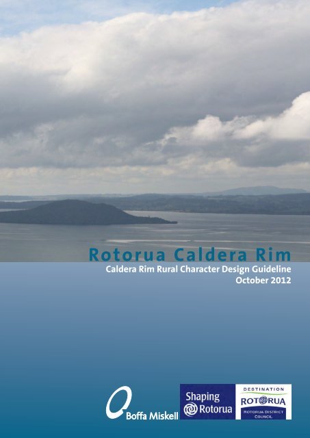
Rotorua Caldera Rim Report - Rotorua District Council
Rotorua Caldera Rim Report - Rotorua District Council
Rotorua Caldera Rim Report - Rotorua District Council

You also want an ePaper? Increase the reach of your titles
YUMPU automatically turns print PDFs into web optimized ePapers that Google loves.
<strong>Rotorua</strong> <strong>Caldera</strong> <strong>Rim</strong><br />
<strong>Caldera</strong> <strong>Rim</strong> Rural Character Design Guideline<br />
October 2012
Prepared by Boffa Miskell Ltd, Tauranga<br />
For:<br />
<strong>Rotorua</strong> <strong>District</strong> <strong>Council</strong><br />
Date: 19th October 2012<br />
Issue: Revision 1<br />
Status: Final<br />
Cover Photograph: Lake <strong>Rotorua</strong> <strong>Caldera</strong>, taken from Mt Ngongotaha, May 2012<br />
BML Document Reference: T11077
<strong>Rotorua</strong> <strong>Caldera</strong> <strong>Rim</strong><br />
<strong>Caldera</strong> <strong>Rim</strong> Rural Character Design Guideline<br />
October 2012
CONTENTS<br />
Executive Summary 7<br />
Part One - Landscape Analysis<br />
Introduction 10<br />
Approach 10<br />
Scoping and Familiarisation 10<br />
Study Area 12<br />
Landscape Character 14<br />
Analysis 16<br />
Defining the <strong>Caldera</strong> <strong>Rim</strong> 22<br />
Sensitive Rural Areas 24<br />
Less Sensitive Rural Areas 26<br />
Case Study: Pukehangi SRA 28<br />
Proposed Residential Areas 30<br />
Part Two - Design Guidelines<br />
Design Guidelines 34<br />
Integrating with the Landscape 35<br />
Subdivision Layout 36<br />
Building Site Location 37<br />
Earthworks 38<br />
Access 39<br />
Infrastructure, Structures and<br />
Landscaping 40<br />
Building Design - Building Form 41<br />
Building Design - Colour and<br />
42<br />
Materials<br />
References 45<br />
Appendix 1<br />
Sensitive Rural Areas<br />
Photographic Montage<br />
ROTORUA CALDERA RIM ::<br />
5
Executive Summary<br />
This report investigates the rural character and amenity of the Lake <strong>Rotorua</strong> <strong>Caldera</strong> landscape and identifies<br />
areas which are sensitive to land use change. The <strong>Rotorua</strong> Landscape Study found that in addition to areas<br />
that were identified as Outstanding Natural Features and Landscapes (ONFLs) there were other areas within the<br />
Lake <strong>Rotorua</strong> <strong>Caldera</strong> that were of value to the community for its rural character and amenity.<br />
Pressures on this rural character and amenity of the <strong>Rotorua</strong> <strong>Caldera</strong> include urban growth, rural subdivision<br />
and changes to land use. The latter is an important environmental outcome identified in the BOP Regional<br />
Policy Statement as they aim to improve lake water quality by reducing nutrient loading. Similarly, the Economic<br />
Growth Strategy requires land within the Lake <strong>Rotorua</strong> <strong>Caldera</strong> <strong>Rim</strong> to be released for future growth.<br />
In order to provide clear direction on how to integrate future growth and land use change into the Lake <strong>Rotorua</strong><br />
<strong>Caldera</strong> landscape, this study assessed the <strong>Caldera</strong> landscape and identified landscape features that have rural<br />
character and amenity values which contribute to the working rural landscape. The key underlying issue is the<br />
management of land use change and subdivision to ensure it is compatible with the natural landform patterns<br />
and processes of the rural landscape and its rural character.<br />
An analysis using a desktop GIS assessment along with ‘on the ground’ field work identified the visual catchment<br />
and visually prominent areas of the <strong>Caldera</strong>. Assessment of the <strong>Caldera</strong> found that the visually prominent<br />
landform does not include all of the elevated land within the caldera rim. The rural character of the lower slopes<br />
are less sensitive to land use change as there are areas of existing development and approved subdivisions (for<br />
future development) along the visual catchment..<br />
The prominent areas of the <strong>Caldera</strong> were identified as “Sensitive Rural Areas “, being land located along the<br />
higher slopes and escarpments, providing a rural backdrop to <strong>Rotorua</strong> and being sensitive to land use change.<br />
The visually prominent areas of the <strong>Caldera</strong> are primarily zoned rural with one residential suburb of Tihi-O-<br />
Tonga located within this area. This and other residential zones have been accepted as part of the existing<br />
environment and have been excluded from the study area.<br />
As a result five Sensitive Rural Areas were identified with the remaining areas in the <strong>Caldera</strong> <strong>Rim</strong> identified as<br />
Less Sensitive Rural Areas having no special rural landscape value. Both the future growth area and areas eligible<br />
for transferrable development rights (to improve lake water quality) as identified in the proposed <strong>District</strong> Plan,<br />
are located within the less sensitive rural area.<br />
Development and land use change is possible in both the Sensitive and Less Sensitive Rural Areas, however<br />
those areas identified as sensitive require a guided approach to ensure the rural character is maintained. Those<br />
areas identified as Less Sensitive are subject to the planning provisions to the applicable Rural Zone and no<br />
special guidance is provided. The Design Guideline, in Part Two of this <strong>Report</strong>, provides appropriate methods<br />
for subdivision and development within the Sensitive Rural Areas. This includes direction on managing site<br />
selection, subdivision layout, building site location, earthworks, access, infrastructure, landscaping and building<br />
design.<br />
The Design Guideline does not prescribe the type of development that would be allowed for e.g. density,<br />
residential or the like. These are controlled under the underlying zoning of the land through activity and<br />
subdivision performance standards. The Design Guidelines provide a framework to assess the suitability of<br />
proposed developments or changes in land use within the sensitive rural backdrop to Lake <strong>Rotorua</strong>.<br />
As a result planning provisions have also been recommended for inclusion into the <strong>District</strong> Plan and include:<br />
• Performance standards for future buildings within Sensitive Rural areas that are established within their<br />
existing development rights (Rural Zone).<br />
• Assessment criteria against which any land use change, development or subdivision on land located within<br />
the Sensitive Rural Areas can be assessed. The application of the Design Guideline will be used as a reference<br />
document when assessing applications.<br />
• The Design Guide can be referred to for managing development in the Less Sensitive Rural Areas however no<br />
further planning provisions above those for the Rural Zone are necessary for these areas.<br />
LANDSCAPE ANALYSIS<br />
ROTORUA CALDERA RIM ::<br />
7
PART ONE :: LANDSCAPE ANALYSIS
Introduction<br />
LANDSCAPE ANALYSIS<br />
This assessment has been prepared as part of the<br />
<strong>Rotorua</strong> <strong>District</strong> <strong>Council</strong>’s review of its <strong>District</strong> Plan.<br />
The objective of the study is to develop a best practice<br />
subdivision and building design guide for future<br />
buildings on the Lake <strong>Rotorua</strong> <strong>Caldera</strong> <strong>Rim</strong>.<br />
The focus of the study is to identify those areas of<br />
the Lake <strong>Rotorua</strong> <strong>Caldera</strong> landscape which form a key<br />
part of the rural backdrop to the city of <strong>Rotorua</strong>. The<br />
objective of the study is to identify what approach<br />
development should take within these areas.<br />
<strong>Rotorua</strong> <strong>District</strong> <strong>Council</strong> has identified areas for<br />
future growth and this study looks at the ability for<br />
these areas to accommodate land use change. The<br />
study considers the proposed classification and<br />
potential change in character of the rural landscape. It<br />
identifies the rural areas that are sensitive to landuse<br />
change. The Design Guideline provides a method for<br />
designing and assessing appropriate landuse change<br />
within these sensitive areas whilst retaining the rural<br />
character.<br />
By considering the rural character and visual amenity<br />
the study draws upon Section 7(c) of the Resource<br />
Management Act (RMA) 1991.<br />
Approach<br />
The Draft <strong>District</strong> Plan (Draft Plan) and Bay of Plenty<br />
Regional Policy Statement (RPS) identify Outstanding<br />
Natural Features and Landscapes in response to Section<br />
6(b) of the RMA. The management of rural character<br />
and natural heritage are provided for through the<br />
provisions found under the Rural chapter within the<br />
Draft Plan. Special provisions are provided for the<br />
management of the natural and cultural landscapes<br />
for the Lakes A Zone, comprising a design guide for<br />
subdivision and built development.<br />
The rural landscape which surrounds <strong>Rotorua</strong> City<br />
comprises a large part of the Lake <strong>Rotorua</strong> <strong>Caldera</strong> and<br />
the <strong>Caldera</strong> <strong>Rim</strong> itself. This assessment has taken into<br />
account the entire rural landscape within the caldera<br />
and focuses on the <strong>Caldera</strong> <strong>Rim</strong> itself.<br />
The study approach builds upon the previous study<br />
work undertaken, by following these key phases:<br />
1. Reconfirm the landscape character of the Lake<br />
<strong>Rotorua</strong> <strong>Caldera</strong>, already identified in the Lake<br />
<strong>Rotorua</strong> Catchment Landscape Assessment 1 ;<br />
2. Identification of the <strong>Caldera</strong> <strong>Rim</strong> as the outer<br />
extent of the study area;<br />
3. Identification of the <strong>Caldera</strong> <strong>Rim</strong> and its slopes;<br />
4. Identification of sensitive rural landscapes<br />
comprising highly visible landscapes with<br />
dominant rural character;<br />
5. Identification of threats to these landscapes from<br />
development;<br />
6. Identification of areas of proposed development<br />
and the impacts upon the rural character;<br />
7. Development of a subdivision and building design<br />
guide;<br />
8. Development of planning provisions for inclusion<br />
into the Proposed <strong>District</strong> Plan.<br />
The Lake <strong>Rotorua</strong> Catchment Landscape Assessment<br />
identified and defined its interpretation of “Landscape”.<br />
This assessment identified the Lake <strong>Rotorua</strong> <strong>Caldera</strong> as<br />
a andscape that contributed to rural amenity values.<br />
Scoping and Familiarisation<br />
Building upon the June 2010 Lake <strong>Rotorua</strong> Catchment<br />
Landscape Assessment, the project team undertook a<br />
desktop analysis of the existing information relating<br />
to the Lake <strong>Rotorua</strong> <strong>Caldera</strong>. A series of maps were<br />
produced taking into account the natural and cultural<br />
(man made) elements and patterns of the study area.<br />
Following this work, the study team undertook site<br />
visits traversing the <strong>Rotorua</strong> <strong>Caldera</strong> landscape.<br />
The landscape characteristics were identified and<br />
visual prominence of the <strong>Caldera</strong> <strong>Rim</strong> observed from<br />
numerous public viewpoints.<br />
ROTORUA CALDERA RIM ::<br />
1 Lake <strong>Rotorua</strong> Catchment Landscape Assessment, June 2010, Boffa<br />
Miskell Ltd.<br />
10
Study Area<br />
Parts of the Lake <strong>Rotorua</strong> <strong>Caldera</strong> have been<br />
identified as being Outstanding Natural Features<br />
and Landscapes(‘ONFL’) as part of an earlier study<br />
prepared by Boffa Miskell Ltd in June 2010. The three<br />
ONFL’s within the Lake <strong>Rotorua</strong> <strong>Caldera</strong> Study area<br />
were identified as being the Hamurana Ridge, Mount<br />
Ngongotaha and the Whakarewarewa Geothermal<br />
area. Together these comprise a small proportion of<br />
the wider caldera landscape context including the 72<br />
kilometre perimeter of the <strong>Caldera</strong> <strong>Rim</strong>.<br />
The study area has been identified by mapping the area<br />
of the <strong>Caldera</strong> from its ridgeline to the waters edge of<br />
Lake <strong>Rotorua</strong>. Further analysis was then applied to<br />
consider the:<br />
• Existing Landscape Character Areas 1 ;<br />
• Applicable zones being Rural, Reserve and Maori<br />
land; and<br />
• Exclusion of Residential, Commercial and Industrial<br />
zones.<br />
It is important to note that the <strong>Caldera</strong> itself comprises<br />
Lake <strong>Rotorua</strong> and its margins. The ‘<strong>Rim</strong>’ is considered to<br />
be the mid to upper slopes of the <strong>Caldera</strong>. The lowland<br />
plains and foothills residing within the study area are<br />
not distinctively part of the <strong>Caldera</strong> <strong>Rim</strong> feature.<br />
LANDSCAPE ANALYSIS<br />
ROTORUA CALDERA RIM ::<br />
1 Lake <strong>Rotorua</strong> Catchment Landscape Assessment, June 2010, Boffa<br />
Miskell Ltd<br />
12
MAP OF STUDY AREA<br />
Scale 1:120,000
Landscape Character<br />
LANDSCAPE ANALYSIS<br />
ROTORUA CALDERA RIM ::<br />
14<br />
The Lake <strong>Rotorua</strong> Catchment Landscape Assessment<br />
identified eleven (11) landscape types within the Lake<br />
<strong>Rotorua</strong> catchment. Within these 39 character areas<br />
were also identified demonstrating unique or binding<br />
characteristics that defined one area from another.<br />
These areas cross the boundary of the <strong>Caldera</strong> <strong>Rim</strong><br />
as some areas across the study area display the same<br />
characteristics.<br />
Specific landscape management outcomes were<br />
identified within each of these Landscape Character<br />
Areas (LCA’s). Within the study area all 39 character<br />
areas are, to varying degrees, part of the <strong>Caldera</strong> <strong>Rim</strong>.<br />
The Lake <strong>Rotorua</strong> <strong>Caldera</strong> itself is characterised by its<br />
rural productive land use. The rolling to very steep<br />
scarps form a dominant backdrop to the lake and<br />
residential settlement patterns. Throughout the<br />
<strong>Caldera</strong> landform dominates the skyline, with some<br />
areas comprising built development and productive<br />
forestry.<br />
Subdivision of rural land has been clustered within<br />
broader landscapes and, up until now, has located<br />
itself on the mid to lower slopes of the <strong>Caldera</strong> <strong>Rim</strong>.<br />
Views from public roads present views of the lake with<br />
a rural backdrop. Residential development is settled on<br />
the lower slopes with the rural land use emphasising<br />
the natural landform and patterns of the upper slopes.<br />
The key underlying management issue is the<br />
management of subdivision in the rural landscape<br />
that is respondent to the natural landform, patterns,<br />
and processes. Similarly the spatial context of<br />
built development in a rural environment forms an<br />
important part of the rural character, whereby large<br />
open areas of rural productive land use are maintained<br />
along with the distinctive natural features which<br />
dominate the <strong>Rotorua</strong> <strong>Caldera</strong> <strong>Rim</strong> and the skyline.<br />
Landscape Character Area (percentage of area within Study Area)<br />
1 Awahou (100%) 15 Mourea Hill (35%) 29 <strong>Rotorua</strong> City and Suburbs (100%)<br />
2 Eastern Rural Hills (83%) 16 Ngapuna (100%) 30 South-eastern Suburbs (100%)<br />
3 Eastern Rural Terrace (98%) 17 Ngongotaha Domes (100%) 31 South-western Suburbs (100%)<br />
4 Hamurana East (100%) 18 Ngongotaha Lakeside (100%) 32 Tarukenga East (93%)<br />
5 Hamurana North (100%) 19 Ngongotaha Scarp and Lower Slopes (92%) 33 Te Ngae (100%)<br />
6 Hamurana West (100%) 20 Ngongotaha Valley (24%) 34 Te Waerenga (35%)<br />
7 Hannahs Bay (100%) 21 Northern <strong>Caldera</strong> Scarp (100%) 35 Te Waerenga Road North (4%)<br />
8 Lake Rotoiti and Margins (0%) 22 North-western Suburbs (100%) 36 Tihi-o-tonga (85%)<br />
9 Lake <strong>Rotorua</strong> Waters (100%) 23 Ohinemutu / Kawaha Point (100%) 37 Waikuta (100%)<br />
10 Lower Plateau Slopes (95%) 24 Okareka Northwestern Hills (2%) 38 Waipa Hills (12%)<br />
11 Mamaku Forestlands (1%) 25 Pohue Bay (100%) 39 Whakarewarewa (99%)<br />
12 Mamaku Rural (4%) 26 Pukehangi (71%)<br />
13 Mokoia Island (100%) 27 Pukepoto - Whakapoungakau Hills (9%)<br />
Key characteristics and management issues identified<br />
within the Lake <strong>Rotorua</strong> Catchment Landscape Study<br />
(June 2010) comprise:<br />
Characteristics<br />
• Limited areas of moderately steep to very steep<br />
terrain with Class 6 soils.<br />
• Land cover is dominated by pasture and limited<br />
areas of cropping and production forestry.<br />
• Land use mainly pastoral with some forestry<br />
and cropping<br />
• Vegetated caldera scarp including a RAP and<br />
PNA.<br />
• Settlement patterns are low density with<br />
rural residential patterns adjoining SH33 and<br />
Brunswick Drive.<br />
• Streams flowing into vegetated and then open<br />
drains.<br />
• Indigenous vegetation mostly in association<br />
with stream systems.<br />
Management Issues<br />
• Slope stabilsation.<br />
• Loss of rural character from subdivision and<br />
potential landscape change in relation to<br />
elevated pastoral hill slopes.<br />
• Protection of caldera topographic feature and<br />
rim / skyline.<br />
• Protection of indigenous vegetation.<br />
• Siting, access and scale of buildings in relation<br />
to existing topography features, drainage<br />
patterns and patterns of vegetation.<br />
• Management of rural character in relation to<br />
road corridors.<br />
• Loss of rural character on steep slopes.<br />
• Siting and design of buildings in relation to<br />
existing topographic features and natural<br />
landform.<br />
14 Mourea / Okawa Bay (28%) 28 Rotokawau Surrounds (0%) Table 1
22<br />
5<br />
6<br />
35<br />
34<br />
4<br />
15<br />
14<br />
10<br />
1<br />
25<br />
8<br />
12<br />
32<br />
18<br />
9<br />
13<br />
28<br />
20<br />
33<br />
11<br />
19<br />
37<br />
23<br />
3<br />
17<br />
7<br />
2<br />
27<br />
21<br />
26<br />
31<br />
29<br />
16<br />
30<br />
24<br />
36<br />
39<br />
38<br />
MAP OF CHARACTER AREAS<br />
Scale 1:120,000
Analysis<br />
In order to identify those parts of the rural landscape<br />
along the <strong>Caldera</strong> <strong>Rim</strong> which comprise visually<br />
sensitive rural landscapes further assessment was<br />
undertaken. A detailed review of the landform,<br />
elevation, slope, aspect, visibility and vegetation cover<br />
assisted to identify those areas with higher levels of<br />
visual rural amenity.<br />
Areas identified as comprising higher levels of visual<br />
rural amenity were determined by:<br />
• Determining the extent of the <strong>Caldera</strong> landscape<br />
by the combination of the elevation and slope data<br />
sets.<br />
• Analysing the visual prominence of the <strong>Caldera</strong><br />
landscape using the intervisibility, aspect and field<br />
assessment data.<br />
• Reviewing the Landscape Management Issues<br />
identified in the Lake <strong>Rotorua</strong> Catchment<br />
Landscape Study.<br />
Elevation<br />
The Lake <strong>Rotorua</strong> <strong>Caldera</strong> edge varies from a visually<br />
distinctive escarpment and ridgeline to sloping<br />
hillsides with visually undeterminable ridgeline. To the<br />
north of Lake <strong>Rotorua</strong>, at Hamurana, the <strong>Caldera</strong> <strong>Rim</strong><br />
is well defined with a steeply rising escarpment and<br />
clear ridgeline.<br />
To the east the <strong>Caldera</strong> <strong>Rim</strong> falls into a river plain<br />
completely to meet the Ohau Channel that connects<br />
Lake <strong>Rotorua</strong> and Lake Rotoiti. Further south the<br />
<strong>Caldera</strong> <strong>Rim</strong> moves eastward away from the lake edge.<br />
Low wetland and rolling foothills extend eastward to<br />
meet the toe of the <strong>Caldera</strong> <strong>Rim</strong>. The <strong>Caldera</strong> <strong>Rim</strong> rises<br />
from 280m at its northeastern edge to 757m above<br />
sea level along the eastern ridge.<br />
as a feature.<br />
Slope<br />
Identifying the <strong>Caldera</strong> <strong>Rim</strong> relies upon the combination<br />
of elevation and slope. The distinctive elements of the<br />
<strong>Rim</strong> comprises the steeper slopes, escarpments and<br />
cliff faces. To determine those parts of the <strong>Caldera</strong> <strong>Rim</strong><br />
with less ability to absorb change the slopes greater<br />
than 7 degrees were identified as generally being<br />
within the ‘<strong>Caldera</strong> <strong>Rim</strong>’. Those parts of the <strong>Rim</strong> where<br />
the slopes greater than 15 degrees the <strong>Caldera</strong> <strong>Rim</strong> are<br />
generally more visible.<br />
Aspect<br />
Aspect is an important component in determining the<br />
visibility of a landscape. Aspect can be thought of as<br />
slope direction. The values shown on the map are the<br />
compass direction of the aspect, grouped into four<br />
azimuth categories. For example, a slope calculated<br />
as facing 65 degrees (measured clockwise from north)<br />
will be classed as an “East-facing slope.” The mapping<br />
of the aspect for the Lake <strong>Rotorua</strong> <strong>Caldera</strong> is relatively<br />
predictable, however it does assist to identify the<br />
extent of visibility of the <strong>Caldera</strong> <strong>Rim</strong> and the subtleties<br />
of the slope surface.<br />
Intervisibility<br />
The intervisibility analysis used an amalgamation of<br />
several viewshed, or ‘line of sight’ calculations, taken<br />
from 8275 viewpoints placed on the lake’s surface at a<br />
regular 100m grid. When added together, the resultant<br />
inter-visibility map determines the degree to which<br />
parts of the landscape surrounding Lake <strong>Rotorua</strong> are<br />
visible from the lake surface. Or conversely, which<br />
parts of the surrounding landscape have a view of<br />
the lake, and how much of the lake surface is visible.<br />
This analysis provided key information in determining<br />
which parts of the <strong>Caldera</strong> <strong>Rim</strong> were highly visible and<br />
dominant.<br />
LANDSCAPE ANALYSIS<br />
ROTORUA CALDERA RIM ::<br />
To the south the ridgeline becomes more fragmented<br />
and gradually drops in elevation. At the southern<br />
edge the Whakarewarewa Geothermal area resides<br />
immediately at the foot of the <strong>Caldera</strong> <strong>Rim</strong>.<br />
To the west, alongside Pukehangi Road, the <strong>Caldera</strong> <strong>Rim</strong><br />
rises in two steeper terraces to form an intermediary<br />
ridge before rising again to the upper <strong>Caldera</strong> <strong>Rim</strong>.<br />
Mount Ngongotaha, whilst a separate mountain, forms<br />
part of the <strong>Caldera</strong> and in turn provides a ridgeline<br />
for the <strong>Caldera</strong> <strong>Rim</strong>. To the northwest, immediately<br />
north of Mount Ngongotaha, the <strong>Caldera</strong> <strong>Rim</strong> takes<br />
a gradual ascent toward the Mamakau Ranges. It is<br />
here where the elevation was used to generate the<br />
extent of the study area. The Hamurana ridgeline<br />
was extended along this elevation into the Mamakau<br />
plateau to generate a logical extent of the <strong>Caldera</strong> <strong>Rim</strong>,<br />
Parcel<br />
The parcel analysis describes the current landscape<br />
in terms of its parcel sizes. The permitted baseline<br />
of rural development on existing smaller parcels has<br />
been considered along with the potential effects<br />
further subdivision may have on the rural character<br />
and its amenity values.<br />
Identification of these parts of the <strong>Caldera</strong> <strong>Rim</strong> as<br />
part of the analysis phase has resulted in four large<br />
Sensitive Rural Areas.<br />
16
ELEVATION MAP<br />
Elevation<br />
metres above sea level<br />
High : 760<br />
Scale 1:120,000<br />
Low : 200
SLOPE MAP<br />
Scale 1:120,000<br />
Slope<br />
< 3°<br />
3 - 7°<br />
7 - 15°<br />
15 - 25°<br />
25 - 34°<br />
> 34°
ASPECT MAP<br />
Aspect<br />
degrees clockwise from north<br />
Flat<br />
North (315°-45°)<br />
East (45°-135°)<br />
South (135°-225°)<br />
West (225°-315°)<br />
Scale 1:120,000
MAP OF INTERVISIBILITY<br />
Scale 1:120,000<br />
Intervisibility<br />
Proportion of Lake Visible<br />
High<br />
Low
MAP OF PARCEL SIZES<br />
Parcel Area<br />
square metres<br />
0 - 2500<br />
2501 - 8000<br />
8001 - 40000<br />
> 40001<br />
Scale 1:120,000
Defining the <strong>Caldera</strong> <strong>Rim</strong> Feature<br />
As a result of the analysis the inner edge of the <strong>Caldera</strong><br />
<strong>Rim</strong> has been mapped. This indicates the refined study<br />
area in which the assessment of the rural amenity<br />
attributes has been applied.<br />
Defining the <strong>Caldera</strong> <strong>Rim</strong> used a combination of the<br />
following criteria:<br />
• Slope - where the gradient of the slope transitions<br />
from 7 degrees to 15 degrees.<br />
• Geomorphology - where the <strong>Caldera</strong> <strong>Rim</strong> is<br />
distinctive and representative.<br />
• Zones - Only areas which are zoned as Rural, Reserve<br />
or Maori Land. All existing residential zones have<br />
been excluded.<br />
The following Design Guideline does not place specific<br />
weight on those areas outside the identified <strong>Caldera</strong><br />
<strong>Rim</strong>. The methods for managing rural character are<br />
not without merit in these areas and can be applied.<br />
However these areas are less sensitive and have an<br />
increased ability to visually integrate land use change.<br />
By refining the <strong>Caldera</strong> <strong>Rim</strong> to exclude the lower slopes,<br />
the <strong>Caldera</strong> <strong>Rim</strong> itself is clearly identified. Whilst<br />
not within the refined study area, the lower areas<br />
of the caldera within the rural zone, will still require<br />
consideration of rural amenity. However these areas<br />
have different qualities and attributes to that of the<br />
<strong>Caldera</strong> <strong>Rim</strong>.<br />
ROTORUA CALDERA RIM ::<br />
LANDSCAPE ANALYSIS<br />
22
MAP OF CALDERA RIM<br />
Scale 1:120,000
Sensitive Rural Areas<br />
Areas where the rural landscape is highly sensitive to<br />
landscape change have been mapped as part of the<br />
identification of the Outstanding Natural Features and<br />
Landscapes (ONFLs) , within the June 2010 Landscape<br />
Study. Development in these areas require further<br />
consideration of the assessment criteria set out in<br />
the Regional Policy Statement and in turn the <strong>Rotorua</strong><br />
<strong>District</strong> Plan.<br />
The identification of the <strong>Rotorua</strong> <strong>Caldera</strong> <strong>Rim</strong> as a<br />
separate landscape area denotes the importance of<br />
this landform has to the <strong>District</strong>. The elevated position<br />
of the <strong>Caldera</strong>, its landform and representativeness<br />
of the volcanic geomorphology is an important<br />
component of <strong>Rotorua</strong>’s landscape character.<br />
Identification of the prominent and highly visible parts<br />
of the <strong>Caldera</strong> <strong>Rim</strong> has resulted in the mapping of four<br />
Sensitive Rural Areas. They are representative of the<br />
natural patterns and processes which have shaped<br />
the land. They are largely void of built form and the<br />
landform dominates the skyline. They contribute<br />
strongly to the character and amenity of the rural<br />
landscape of the <strong>Rotorua</strong> <strong>Caldera</strong>.<br />
The Design Guideline outlines the key methods for<br />
management of change in these sensitive landscapes.<br />
Similarly these methods can be used in other areas of<br />
the rural landscape within the <strong>Caldera</strong>.<br />
The rural landscape of the <strong>Caldera</strong> <strong>Rim</strong> varies around<br />
Lake <strong>Rotorua</strong>, but it is largely within pasture with<br />
pocketed areas of rural residential subdivision. The<br />
<strong>Caldera</strong> <strong>Rim</strong> varies in landform and landcover, with the<br />
lower less steep slopes of the <strong>Caldera</strong> <strong>Rim</strong> containing<br />
more extensive vegetation cover, including forestry.<br />
The steeper slopes, conversely, are largely void of<br />
significant vegetation cover.<br />
ROTORUA CALDERA RIM ::<br />
LANDSCAPE ANALYSIS<br />
m <strong>Rotorua</strong> Museum towards Lynmore<br />
24<br />
Sensitive Rural Area - View looking east toward Lynmore
MAP OF SENSITIVE RURAL AREAS<br />
Sensitive Rural Areas<br />
Scale 1:120,000<br />
ONFL Areas
Less Sensitive Rural Areas<br />
The remaining areas sited outside those identified<br />
Sensitive Rural Areas are considered to still contain<br />
rural character and amenity values.<br />
Rural amenity is still considered important, however<br />
these areas have a greater ability to accommodate<br />
change due to a number of factors:<br />
• Low foothills that are undulating with a number of<br />
low lying ridgelines and valleys.<br />
• Existing native and exotic vegetation cover.<br />
• Areas less visible from wider public viewpoints.<br />
These areas form part of the <strong>Caldera</strong> <strong>Rim</strong> and are<br />
important as part of the continuous rural landscape.<br />
Rural amenity continues to be considered for these<br />
areas through <strong>District</strong> Plan provisions. However the<br />
extent of controls in place are not as detailed as those<br />
with identified Sensitive Rural Areas.<br />
ROTORUA CALDERA RIM ::<br />
LANDSCAPE ANALYSIS<br />
26
MAP OF LESS SENSITIVE RURAL AREAS<br />
Less Sensitive Rural Areas<br />
Scale 1:120,000
Case Study:<br />
Pukehangi Sensitive Rural Area<br />
Within each of the Sensitive Rural Areas (‘SRA’) there<br />
are subtleties of landform and vegetation patterns<br />
that contribute to the prominence and, conversely,<br />
screening of features.<br />
An example of these subtleties can be seen within<br />
the Pukehangi Sensitive Rural Area, where the slope<br />
analysis identifies unique variations in landform.<br />
The steeper slopes, identified as blue and purple, are<br />
areas where access becomes difficult to naturally<br />
achieve and building upon these slopes often results<br />
in prominent structures.<br />
The visibility and connectivity of this feature is<br />
important to the recognition of the <strong>Rotorua</strong> <strong>Caldera</strong><br />
<strong>Rim</strong>. The mid and upper slopes and terraces of this part<br />
of the <strong>Caldera</strong> <strong>Rim</strong> provide a prominent and contiguous<br />
backdrop to <strong>Rotorua</strong> City. This area is representative of<br />
the <strong>Caldera</strong> <strong>Rim</strong> and is visually prominent. The rural<br />
character and amenity of this landscape contributes<br />
positively to the wider <strong>Rotorua</strong> <strong>Caldera</strong> landscape.<br />
Within these sensitive landscapes the gully and their<br />
steep slopes can be utilised for native vegetation cover.<br />
This can reinforce the natural patterns of the landform<br />
and assist to integrate built form into the landscape.<br />
A detailed slope analysis of the Pukehangi Sensitive<br />
Rural Area shows there are some gullies and<br />
escarpments which can be utilised. However this<br />
analysis shows that the key main gullies are orientated<br />
away from the main viewing catchment of <strong>Rotorua</strong><br />
City and Lake <strong>Rotorua</strong>,<br />
The lower slopes of the Pukehangi SRA have capability<br />
to incorporate vegetation cover which can provide<br />
a backdrop to built development at the very eastern<br />
edge of the slope. This may provide further ability for<br />
the lower slopes to accomodate built development<br />
greater than expected within a Rural Zone, however<br />
specific analysis of all landscape factors would be<br />
required with any proposal.<br />
ROTORUA CALDERA RIM ::<br />
LANDSCAPE ANALYSIS<br />
ards Ngatautara<br />
28<br />
Sensitive Rural Area - View looking west toward Pukehangi
PUKEHANGI ‘SRA’ - SLOPE ANALYSIS<br />
Sensitive Areas<br />
Scale 1:35,000<br />
Slope (degrees)<br />
0 - 3<br />
4 - 7<br />
8 - 15<br />
16 - 25<br />
26 - 76
Proposed Residential Areas<br />
LANDSCAPE ANALYSIS<br />
ROTORUA CALDERA RIM ::<br />
As part of the preparation of the Proposed <strong>District</strong> Plan<br />
a number of proposals have been proffered. These<br />
include Residential and Rural development.<br />
Some of these particular proposals are sited within the<br />
identified Sensitive Rural Areas. Areas which contribute<br />
to the rural amenity of the <strong>Rotorua</strong> <strong>Caldera</strong> and are<br />
landforms strongly representative of the <strong>Caldera</strong><br />
<strong>Rim</strong>’s geomorphology. The Sensitive Rural Areas<br />
are not considered Outstanding Natural Features or<br />
Landscapes. However the key objective in managing<br />
these particular landscape areas is the maintenance of<br />
rural amenity and rural character.<br />
The qualities, attributes and values of these landscape<br />
features have been identified and design methods for<br />
appropriate development in these areas proposed.<br />
There are four areas where the proposed development<br />
may extend into the identified Sensitive Rural Areas:<br />
1. Pukehangi Road extension<br />
2. South of State Highway 33<br />
3. The area to the east of Iles Road<br />
4. Hamurana, adjoining an existing residential<br />
settlement.<br />
1. Pukehangi Road Extension<br />
The landform provides a rural backdrop to the urban<br />
subdivision and Pukehangi Road forms the zone<br />
boundary. This area is highly visible and the open<br />
rural character accentuates the natural landform and<br />
geomorphology of the <strong>Caldera</strong> <strong>Rim</strong>. This area also<br />
connects visually to Mount Ngongotaha reinforcing<br />
the <strong>Caldera</strong> <strong>Rim</strong> as a feature.<br />
There are two prominent terraces within this Sensitive<br />
Rural Area. The lower terraces having more visual<br />
connection to the urban residential development. It<br />
is a long wide terrace that visually dominates this part<br />
of the <strong>Caldera</strong> <strong>Rim</strong> with the upper terrace forming the<br />
top third of the <strong>Caldera</strong> <strong>Rim</strong>.<br />
Development in this area should take into account the<br />
rural character and amenity values. Density within<br />
this area should be in keeping with the rural amenity<br />
values and protect the <strong>Caldera</strong> ridgeline from built<br />
development. The lower slopes of this area have<br />
some ability to create connections with surrounding<br />
residential development, however above the RL385<br />
contour the rural character of the site should be<br />
maintained.<br />
2. South of State Highway 33<br />
This area has been identified as being part of the<br />
<strong>Caldera</strong> <strong>Rim</strong> and the lower rural plains between the<br />
<strong>Caldera</strong> <strong>Rim</strong> and lake edge. The proposed development<br />
area traverses both the Sensitive Rural Area and Less<br />
Sensitive Rural Areas. Development in this area would<br />
still require consideration of the rural amenity through<br />
application of the guidelines. The visual prominence<br />
of the Less Sensitive Areas on the wider <strong>Rotorua</strong><br />
visual catchment is diminished due to the undulating<br />
landform and intensive land cover found throughout<br />
the area.<br />
The upper extent of the proposed development area is<br />
located within the Sensitive Rural Area. Development<br />
in this area is considered highly sensitive and must<br />
take into account maintenance of the low density,<br />
open space, and existing built development patterns.<br />
The landform and geomorphology of this area is<br />
very important to the rural character and should be<br />
maintained when considering future development.<br />
3. Area to the East of Iles Road.<br />
This area is located in a visually prominent rural site<br />
with open pastoral rural character. The landform<br />
steeply rises above the urban development and<br />
forms a dominant rural backdrop to <strong>Rotorua</strong> city. The<br />
landform is representative of the natural processes<br />
which formed it and the land use further accentuates<br />
these patterns.<br />
There are a series of terraces immediately behind the<br />
Iles Road area which create a number of plateau. These<br />
areas are connected to the wider rural landscape and<br />
any development in these areas should consider the<br />
highly sensitive nature of this landscape. Adjoining<br />
this area, Tarawera Road creates a gateway between<br />
the Lakes A Zone and <strong>Rotorua</strong> town. Views from this<br />
road down across Lake <strong>Rotorua</strong> are significant and<br />
dramatic. Development should be low key in nature<br />
and responsive to the dominant rural amenity values<br />
of this area.<br />
4. Hamurana Rural Residential Extension<br />
This area adjoins an existing rural residential<br />
development along the Lake edge. It is located outside<br />
the <strong>Caldera</strong> <strong>Rim</strong> Sensitive Rural Area. Rural Residential<br />
Development is dominant in this area and is bounded<br />
by the change in landform. Development should be<br />
responsive to the rural amenity values and the natural<br />
patterns of this landscape.<br />
30
4<br />
2<br />
1<br />
3<br />
MAP OF AREAS FOR PROPOSED DEVELOPMENT<br />
Proposed Development Areas<br />
Sensitive Areas<br />
Less Sensitive Areas<br />
ONFL Areas<br />
Scale 1:120,000
PART TWO :: DESIGN GUIDELINE<br />
Guide for Subdivision in the <strong>Caldera</strong> <strong>Rim</strong> Sensitive Rural Areas
Purpose of Design Guidelines<br />
The purpose of these design guidelines is to provide<br />
techniques and methods for developing appropriate<br />
development in the identified Sensitive Rural Areas.<br />
<strong>Caldera</strong> <strong>Rim</strong> Attributes<br />
The key attributes and qualities of the Lake <strong>Rotorua</strong><br />
<strong>Caldera</strong> are largely the same across each of the<br />
identified Sensitive Rural Areas. These attributes are<br />
found throughout most of the rural areas within a<br />
Rural 1 Zone plan areas. The distinctive landform and<br />
visibility of these landscapes reduces the ability for a<br />
change in land use to be visually absorbed.<br />
These attributes comprise:<br />
Landform: The open rural landscape of the <strong>Caldera</strong><br />
<strong>Rim</strong> forms a wide buffer between the urban<br />
settlements and the wider rural landscape. The<br />
landform is moderately to extremely steep and has<br />
a series of ridgelines that create the broader <strong>Caldera</strong><br />
<strong>Rim</strong> ridgeline.<br />
Open Space: The rural open space dominated by<br />
open grazing paddocks with pockets of indigenous<br />
vegetation line the <strong>Caldera</strong> <strong>Rim</strong>. The spatial<br />
arrangement of buildings in this landscape forms the<br />
rural character and contributes to the rural amenity<br />
enjoyed by those viewing and living within the area.<br />
Built Form: The <strong>Caldera</strong> <strong>Rim</strong> is low density in its<br />
development creating opportunity for the landform<br />
to dominate the view. For the most part, housing<br />
along the <strong>Caldera</strong> <strong>Rim</strong> ridgeline is minimal creating a<br />
built free skyline. Buildings are generally low key and<br />
of typical small to medium scaled rural housing style.<br />
How to Use the Guidelines<br />
The application of the guidelines is intended for<br />
consideration of all matters relating to rural character<br />
and amenity. It is not a ’tick box’ or ‘pick and choose’<br />
exercise. Each component of the guideline should be<br />
considered and addressed following a design process.<br />
The ‘appropriateness’ of a development within<br />
these sensitive rural landscapes is driven firstly by<br />
recognition of the attributes the landscape contains<br />
that need to be maintained. Consideration of not<br />
only the proposed site but the wider context is crucial<br />
for successful integration into a rural landscape.<br />
By applying the guidelines at the key stages the<br />
following process should be undertaken:<br />
Site Selection<br />
Integrating with Landscape<br />
Subdivision Layout<br />
Building Site Location<br />
Earthworks<br />
Subdivision Design & Consenting<br />
Integrating with Landscape<br />
Subdivision Layout<br />
Building Site Location<br />
Earthworks<br />
Access<br />
Infrastructure, Structures and<br />
Landscaping Proposed<br />
Building Design<br />
DESIGN GUIDELINE<br />
ROTORUA CALDERA RIM ::<br />
Land Cover: The land use directly corresponds to<br />
the type of land cover. The Sensitive Rural Areas are<br />
largely void of vegetation cover, with some pockets<br />
of remnant native vegetation in the valleys. Large<br />
open pastoral paddocks extend across the landscape<br />
accentuating the landform underneath.<br />
Detailed Design<br />
Building Site Location<br />
Earthworks<br />
Access<br />
Infrastructure, Structures and<br />
Landscaping<br />
Building Design<br />
The process may require revisiting steps in order<br />
to gain the best outcome for the site<br />
34
Integrating with Landscape<br />
Selecting a site for development within an identified Sensitive Rural Area must take into account the subtleties<br />
of the site. The natural and cultural patterns of the landscape are key attributes to work with for sensitive<br />
design. Select a site that provides opportunities for development to integrate with the existing landscape<br />
patterns.<br />
Any subdivision within the Sensitive Rural Areas should be low in density and highly responsive to the rural<br />
character of the landscape. Typical residential subdivision is considered inappropriate in the Sensitive Rural<br />
Areas.<br />
Approach<br />
Seek out parts of the site that are able to accommodate and visually absorb development. These are<br />
generally on the lower slopes of the <strong>Caldera</strong> <strong>Rim</strong> and are less visible. They can have existing vegetation<br />
and development occurring near to or on the site.<br />
Avoid:<br />
• The upper parts of the <strong>Caldera</strong> <strong>Rim</strong> escarpments.<br />
• Prominent features of the <strong>Caldera</strong> <strong>Rim</strong> landform.<br />
• Steep slopes requiring extensive earthworks.<br />
• Open pasture landscapes with no development.<br />
• The dominant <strong>Caldera</strong> <strong>Rim</strong> ridgeline and skyline.<br />
By Selecting Sites that:<br />
• Have flat areas and low rolling foothill slopes.<br />
• Area located on the toe of the main caldera ridge.<br />
• Are set back against the escarpment on plateau.<br />
• Have vegetation cover and existing development surrounding it.<br />
• Retain the productive land use of the rural landscape.<br />
• Can contribute to restoration of indigenous vegetation.<br />
ROTORUA CALDERA RIM ::<br />
DESIGN GUIDELINE<br />
35
Subdivision Layout<br />
Subdivision layout is the key factor in determining the appropriate density, spatial proportions, earthworks and<br />
infrastructure required.<br />
Approach<br />
Design a subdivision layout that clusters building sites and responds to the natural underlying landform.<br />
Use the natural landform and features to nestle the development against. Identify the important features<br />
on the site and avoid these areas.<br />
Avoid:<br />
• Grid like patterns that are in contrast to the natural patterns of the landform and land cover.<br />
• Spreading building sites evenly across a site breaking the spatial proportions.<br />
• Dense patterns of subdivision that will dominate the landscape.<br />
• Lot boundary alignments that ‘divide’ the natural patterns by application of boundary fencing and<br />
planting.<br />
• Avoid ridgelines of spurs as boundary locations.<br />
• Subdivision within 50 vertical metres of the <strong>Caldera</strong> <strong>Rim</strong> ridgeline.<br />
DESIGN GUIDELINE<br />
ROTORUA CALDERA RIM ::<br />
By Designing Layouts that:<br />
• Limit lot densities to integrate with the<br />
existing development patterns.<br />
• Create distances between building areas<br />
that reflect the spatial distance already<br />
found within the Sensitive Rural Areas.<br />
• Cluster building sites together to retain<br />
productive land use and open space<br />
qualities.<br />
• Align boundaries to natural patterns,<br />
streams, valleys and stands of<br />
nonproductive vegetation.<br />
• Protect areas of natural vegetation,<br />
springs and wetlands.<br />
• Use gully systems to locate vegetation<br />
along steep escarpments, creating a<br />
vegetation network that can provide<br />
screening of built form.<br />
36
Building Site Location<br />
After deciding upon the subdivision layout the placement of buildings into each lot is the next step to creating<br />
a development that integrates with the landscape. Placing buildings immediately near or on the <strong>Caldera</strong><br />
<strong>Rim</strong> ridgeline and skyline is inappropriate. Also the spatial distances between house sites and the extent of<br />
remaining open space will reflect the density of development and, in turn, affect the character of the Sensitive<br />
Rural Area.<br />
Approach<br />
Select building sites that require minimal disruption to the landscape . Use natural flat areas to locate<br />
house sites, avoiding ridgelines and nestle buildings into the landscape. Use the natural landform to create<br />
a backdrop rather than the skyline as a backdrop.<br />
Avoid:<br />
• The <strong>Caldera</strong> <strong>Rim</strong> ridgeline and buildings that interrupt the skyline.<br />
• Siting buildings in a prominent location and at the edge of a plateau.<br />
• Buildings sites that require excessive earthworks (cut and fill).<br />
• Buildings sites that dominate the road frontage.<br />
• Spreading buildings evenly across a site creating a ‘cluttered’ landscape.<br />
• Avoid building sites that require extensive access requirements (i.e. earthworks, bridges, retaining, etc)<br />
• House sites that have extensive curtilage and ancillary buildings (eg. Garden sheds, garage, etc).<br />
• That block open views from public roads and viewpoints of the rural landscape.<br />
By Designing House Sites that:<br />
• Use the landform as a backdrop.<br />
• Are placed at the mid to lower slopes of the Sensitive Rural Areas.<br />
• Are clustered together to maximise the open rural landscape between.<br />
• Are nestled into the landscape, using landform changes, valleys, gully sides and lower terraces.<br />
• Are set back from the road similar to other buildings within the rural landscape.<br />
• Are set well back from the edge of hillsides, knolls and plateaux to minimise the prominence of the<br />
building.<br />
• Group or attach buildings within a lot together to minimise building ‘spread’ and clutter in the lot and<br />
subdivision.<br />
ROTORUA CALDERA RIM ::<br />
DESIGN GUIDELINE<br />
37
Earthworks<br />
Avoiding earthworks on hillsides in the Sensitive Rural Areas is difficult. However earthworks can significantly<br />
alter the natural patterns and processes which occur on a landscape. Poorly designed earthworks can result in<br />
a scarring effect on a landscape. Working with the natural patterns and process in the early design stages is<br />
crucial to minimising the extent of earthworks required.<br />
Approach<br />
Identify natural flat areas and patterns to minimise earthworks throughout the site. Identify prominent<br />
features to avoid within the site and natural processes, including waterways to protect.<br />
Avoid:<br />
• Extensive and invasive earthworks that will permanently scar the landscape.<br />
• Creating vertical faces and slopes that are incongruent with the surrounding landform gradients.<br />
• Even and linear earth shaping patterns.<br />
• Large cut batters that are difficult to maintain or return to productive land use.<br />
• Any earthworks along the ridgeline of the Sensitive Rural Areas and prominent features within.<br />
• Creating accessways and roads that excessively cut across a hillside or into a slope.<br />
DESIGN GUIDELINE<br />
By:<br />
• Locating house sites and access roads that require minimal earthworks.<br />
• Using naturally flat areas to locate house sites.<br />
• Using the natural landform to locate accessways that require minimal earthworks and retaining.<br />
• Using cut and fill material is reshaped to ‘marry into’ the surrounding landform.<br />
• Rehabilitate cut batters / embankments with vegetation or grass.<br />
• Minimising retaining structures and visually obscuring them from view.<br />
• Minimise vertical cut faces to no greater than 1.5m in height.<br />
ROTORUA CALDERA RIM ::<br />
38
Access<br />
Access into and through a site can work with the natural landform creating minimal disruption. Conversely,<br />
accessways that do not respond to the natural landform tend to create scarring and highlight the accessway<br />
itself.<br />
Approach<br />
Design an accessway network that works with the natural landform and minimises the amount of<br />
accessway required. This is where clustering of house sites can be beneficial.<br />
Avoid:<br />
• Locating accessways across or over ridgelines.<br />
• Cut through a landscape and a linear pattern or direct route, despite the landform.<br />
• Urban roading standards e.g. vertical kerb and channel etc.<br />
• Wide roads requiring excessive earthworks.<br />
• Locating accessways in the upper third of the rim face within the Sensitive Rural Areas.<br />
• Numerous entrances off a public road.<br />
By:<br />
• Following the contours of the landform to hide accessways behind landform features.<br />
• Following natural vegetation patterns.<br />
• Minimising distance of accessways required by having multiple access points from one access road.<br />
• Using low impact stormwater design such as open swale systems.<br />
• Using ‘rural’ roading methods, narrow roads, flat kerb, mountable or no formed kerb and channel.<br />
• Using shared driveways and clustering lots.<br />
ROTORUA CALDERA RIM ::<br />
DESIGN GUIDELINE<br />
39
Infrastructure, Structures and Landscaping<br />
Structures and landscaping across a site and within individual lots form the characteristics of the rural<br />
environment. For the <strong>Caldera</strong> <strong>Rim</strong> Sensitive Rural Areas, the frequency, type and location of these features<br />
collectively form the character of these areas. Servicing development requires a number of underground<br />
services. Overhead servicing in new subdivisions is rarely found and is not considered appropriate within the<br />
Sensitive Rural Areas. Planting itself is not a sole method that can be applied for integrating development.<br />
Poor placement of planting can detract from the natural and cultural patterns of the rural landscape.<br />
Approach<br />
Following on from the subdivision and building site designs which follow the natural landscape patterns,<br />
locating infrastructure should continue this approach. Review the existing elements of the Sensitive<br />
Rural Area. Design the location, density and scale of the proposed structures and landscaping to work and<br />
integrate with the surrounding elements.<br />
Avoid:<br />
• Locating pump stations, water tanks or similar buildings on prominent locations and avoid the <strong>Caldera</strong><br />
<strong>Rim</strong> ridgeline.<br />
• Stormwater management that avoids working with the natural watershed patterns.<br />
• Cutting across cultural and natural landscape patterns.<br />
• Creating isolated planted areas around separate<br />
house sites.<br />
• Avoid urban planting design within the street<br />
area and alongside roads.<br />
• Clearing existing vegetation patterns.<br />
• Creating fencelines that cut across landscapes.<br />
• Urban entranceways or gateways.<br />
• Urban style fencing e.g. solid post and panel<br />
close boarded fences.<br />
• Lighting of rural roads and outdoor areas.<br />
• Exposed retaining structures along the face of<br />
the slopes.<br />
DESIGN GUIDELINE<br />
ROTORUA CALDERA RIM ::<br />
By:<br />
• Installing all services underground.<br />
• Locating pump stations, water tanks off ridgelines and off the <strong>Caldera</strong> <strong>Rim</strong> ridgeline.<br />
• Integrating low impact design methods for stormwater management. Integrating with the natural<br />
features of the site.<br />
• Locating fencelines to follow natural contours.<br />
• Creating connected vegetation patterns that link sites together and connect to the natural vegetation<br />
patterns and landform.<br />
• Use rural style fencing that is visually unobtrusive and permeable e.g. low post and rail, post and wire.<br />
• Use indigenous vegetation or large scaled rural trees, matching trees found within the immediate<br />
vicinity.<br />
• Keep entranceways low key, avoiding grand<br />
entranceways or gateways. Use natural materials<br />
such as wood or stone to reflect the rural<br />
character. Avoid plastered fences or gateways.<br />
• Limiting outdoor areas to immediately around<br />
the building, using the remaining lot to create a<br />
visually shared open rural landscape.<br />
• Integrate earth retaining into the natural<br />
contours, screening exposed retaining walls from<br />
view. Use natural materials, avoiding finishes<br />
that reflect urban style retaining and fencing.<br />
40
Building Design - Building Form<br />
Following the appropriate placement of a building site into the rural landscape, the design of a building has<br />
the ability to attract or detract from the rural character of that environment. Smaller scale buildings have the<br />
ability to nestle into a landscape and blend with the environment.<br />
Approach<br />
Design the building to reduce the visual prominence the building may have within that landscape. Review<br />
the landform surrounding the site and design a building that responds to the natural and cultural patterns<br />
of the rural landscape.<br />
Avoid:<br />
• Large scale buildings that are strongly vertical and incongruent with the natural landform patterns.<br />
• Building designs that are out of character with the rural character of the Sensitive Rural Areas.<br />
• Urban buildings and architectural styles that mimic foreign architectural styles rather than respond to<br />
the natural environment of the site.<br />
• Roof lines that are in contrast to the natural<br />
landform.<br />
• Building form that is large in scale and has<br />
no modulation 1 .<br />
• Large areas of prominent glazing and mirror<br />
glazing.<br />
• With buildings on steep slopes the exposure<br />
of basements and foundations is common.<br />
• Avoid creating large basements that increase<br />
the bulk of the building.<br />
By:<br />
• Designing single storey buildings within the Sensitive Rural Areas.<br />
• Designing buildings that have a dominant horizontal profile and are single storey.<br />
• Designing roofs that integrate buildings into the landscape and using a sheltering form with deep<br />
overhangs.<br />
• Using building modulation 2 to break the length of a building facade by changing direction, stepping in<br />
and out of the main facade, balconies, eaves, pergolas and other structures.<br />
• Recessing large areas of glazing below wide eaves and dividing glazing with walls, pergolas and the like.<br />
• Use of tinted glass, but not mirror glazing.<br />
• Buildings that keep in style with the architectural styles of the New Zealand rural landscape and those<br />
found within the rural areas of <strong>Rotorua</strong> <strong>Caldera</strong> <strong>Rim</strong>.<br />
• Designing buildings that utilise natural materials.<br />
• Integrate exposed basement walls into the facade design by extending the materials right to the ground<br />
or using planting to<br />
screen the basement.<br />
• Carefully integrating<br />
chimneys, aerials, satellite<br />
dishes and solar panels<br />
with the overall building<br />
and roof design.<br />
2 Building Modulation is the landscape term used, within this report, to describe the change in direction and depth along a edge of a building.<br />
DESIGN GUIDELINE<br />
ROTORUA CALDERA RIM ::<br />
41
Building Design - Colour and Materials<br />
Colour and material selection has the ability to either integrate or contrast a building to its surrounding<br />
natural environment. The <strong>Caldera</strong> <strong>Rim</strong> Sensitive Rural Areas are largely void of vegetation cover, therefore<br />
selection of materials is critical to the integration of built form within this environment.<br />
Approach<br />
Design the building to reduce the visual prominence the building may have within that landscape by<br />
using recessive building colours and materials that are sympathetic to the colour of the surrounding<br />
natural environment. As a primarily pastoral landscape the Sensitive Rural Areas, comprise green to brown<br />
colourings and therefore any colour selection or materials should be sympathetic to this colour palette.<br />
Before finalising the colour palette consider the change of seasons to ensure the building materials and<br />
colour work in all seasons.<br />
Avoid:<br />
• Materials that are smooth and create a high level of reflectivity.<br />
• Extensive use of materials that are dominant in the urban environment, i.e. brick and tile, plastered<br />
finishes. Some use is suitable but balanced with the selection of materials and colours that are<br />
responsive to the natural environment.<br />
• Use of colour on weatherboard, plaster finishes, roofing and detailing (gutters, window sills, etc.) that is<br />
higher than 37% in reflectivity.<br />
By:<br />
• Selecting materials that respond to the rural landscape and native vegetation immediately surrounding<br />
the subject site.<br />
• Selecting colour palettes that have a reflectance value of less than 37% roofs and walls (Refer to the<br />
Resene British Standard 5252 Range as a guide).<br />
• Using natural material finishes such as stone and timber which will weather naturally.<br />
• Applying dark oxide colouring to concrete materials to reduce reflectivity of the material.<br />
ROTORUA CALDERA RIM ::<br />
DESIGN GUIDELINE<br />
42
REFERENCES<br />
ROTORUA CALDERA RIM ::<br />
REFERENCES<br />
43
ROTORUA CALDERA RIM ::<br />
REFERENCES<br />
44
REFERENCES<br />
Boffa Miskell Ltd, July 2000, The Impact of Rural Subdivision and Development on Landscape Values, prepared<br />
for the Ministry for the Environmnet.<br />
Boffa Miskell Ltd, June 2010. Lake <strong>Rotorua</strong> Catchment Landscape Assessment.<br />
Boffa Miskell Ltd, April 2004. Esk Hills Design Guidelines,.<br />
Hasting <strong>District</strong> <strong>Council</strong> & Isthmus Group, August 2005. The Guide, Good Practice Landscape Guidelines for<br />
Subdivision and Development in the Hastings <strong>District</strong>.<br />
Lucas Associates, September 2002. Lakes A Zone Design Guide for Buildings. <strong>Rotorua</strong> <strong>District</strong> <strong>Council</strong>.<br />
Ministry for the Environment, 2000. The Impact of Rural Subdivision and Development on Landscape Values.<br />
Wellington<br />
Parliamentary Commissioner for the Environment, June 2001. Managing Change in Paradise: Sustainable<br />
Development in Peri-Urban Areas,<br />
ROTORUA CALDERA RIM ::<br />
REFERENCES<br />
45
APPENDIX 1<br />
SENSITIVE RURAL AREA<br />
PHOTOGRAPHIC MONTAGE
Mt Ngongotaha ONFL<br />
<strong>Caldera</strong> rim design guidelines<br />
Sensitive Rural Area - Pukehangi<br />
| Date: 17 October 2012 | Revision: 0 |<br />
Plan prepared for <strong>Rotorua</strong> <strong>District</strong> <strong>Council</strong> by Boffa Miskell Limited<br />
Author: john.watt@boffamiskell.co.nz | Checked: Rebecca Ryder<br />
File Ref: T11077_SensitiveRuralAreasStudy.indd<br />
Figure 1<br />
View South-West from <strong>Rotorua</strong> Museum towards Ngatautara<br />
View North-West from <strong>Rotorua</strong> Museum towards Pukehangi<br />
www.boffamiskell.co.nz<br />
These images have been prepared by Boffa Miskell Limited<br />
on the specific instructions of our Client. It is solely for<br />
our Client’s use in accordance with the agreed scope of<br />
work. Any use or reliance by a third party is at that party’s<br />
own risk. Where information has been supplied by the<br />
Client or obtained from other external sources, it has been<br />
assumed that it is accurate. No liability or responsibility<br />
is accepted by Boffa Miskell Limited for any errors or<br />
omissions to the extent that they arise from inaccurate<br />
information provided by the Client or any external source.<br />
Viewpoint Details<br />
NZTM Easting : 1 885 646 mE Approx.<br />
NZTM Northing : 5 774 154 mN Approx.<br />
Elevation : 297.5m Approx.<br />
Date of Photography : 11:25am, 11 October 2012<br />
Data source: Photography from <strong>Rotorua</strong> <strong>District</strong> <strong>Council</strong><br />
Horizontal Field of View, Top Image: 55° (Rectilinear)<br />
Optimum viewing distance of image @ A3 is 379mm<br />
Horizontal Field of View, Bottom Image: 62° (Rectilinear)<br />
Optimum viewing distance of image @ A3 is 329mm
<strong>Caldera</strong> rim design guidelines<br />
Sensitive Rural Area - Lynmore<br />
| Date: 17 October 2012 | Revision: 0 |<br />
Plan prepared for <strong>Rotorua</strong> <strong>District</strong> <strong>Council</strong> by Boffa Miskell Limited<br />
Author: john.watt@boffamiskell.co.nz | Checked: Rebecca Ryder<br />
File Ref: T11077_SensitiveRuralAreasStudy.indd<br />
Figure 2<br />
View South-East from <strong>Rotorua</strong> Museum towards Lynmore<br />
www.boffamiskell.co.nz<br />
These images have been prepared by Boffa Miskell Limited<br />
on the specific instructions of our Client. It is solely for<br />
our Client’s use in accordance with the agreed scope of<br />
work. Any use or reliance by a third party is at that party’s<br />
own risk. Where information has been supplied by the<br />
Client or obtained from other external sources, it has been<br />
assumed that it is accurate. No liability or responsibility<br />
is accepted by Boffa Miskell Limited for any errors or<br />
omissions to the extent that they arise from inaccurate<br />
information provided by the Client or any external source.<br />
Viewpoint Details<br />
NZTM Easting : 1 885 650 mE Approx.<br />
NZTM Northing : 5 774 154 mN Approx.<br />
Elevation : 297.5m Approx.<br />
Date of Photography : 12:56pm, 11 October 2012<br />
Data source: Photography from <strong>Rotorua</strong> <strong>District</strong> <strong>Council</strong><br />
Horizontal Field of View: 59° (Rectilinear)<br />
Optimum viewing distance of image @ A3 is 349mm