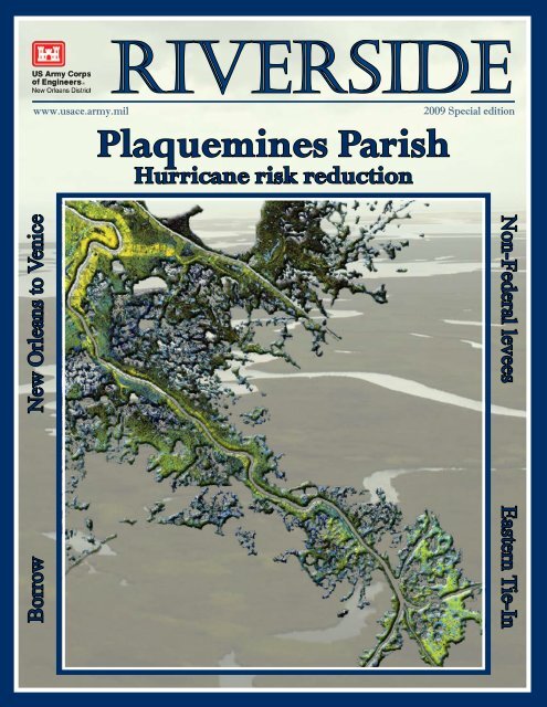
Riverside 2009 Special Edition Plaquemines Parish - NOLA ...
Riverside 2009 Special Edition Plaquemines Parish - NOLA ...
Riverside 2009 Special Edition Plaquemines Parish - NOLA ...

Create successful ePaper yourself
Turn your PDF publications into a flip-book with our unique Google optimized e-Paper software.
www.usace.army.mil<strong>Riverside</strong><br />
<strong>Plaquemines</strong> <strong>Parish</strong><br />
Hurricane risk reduction<br />
<strong>2009</strong> <strong>Special</strong> edition<br />
Borrow New Orleans to Venice<br />
Non-Federal levees Eastern Tie-In
<strong>Riverside</strong><br />
<strong>Special</strong> edition:<br />
Understanding<br />
residual<br />
risk ..........1<br />
The completed Hurricane and<br />
Storm Damage Risk Reduction<br />
System will defend against a<br />
1 percent storm surge event.<br />
However, greater storms can and<br />
will occur in Southeast Louisiana.<br />
A good understanding of this<br />
remaining risk is critical for<br />
ensuring the safety of you and<br />
your family.<br />
Borrow needed for<br />
<strong>Plaquemines</strong> projects........................2<br />
Suitable clay material, called borrow, is needed for levee construction in<br />
Southeast Louisiana. The unprecedented amount of clay needed calls for the<br />
Corps to use three different procurement methods in hopes of identifying<br />
appropriate sources.<br />
Eastern Tie-In.............................................3<br />
The environmental document for the Hero Canal Levee and Eastern Tie-In outlines<br />
the Corps’ plan of action for connecting West Bank levees to the Mississippi River<br />
system.
New Orleans to Venice<br />
public scoping meetings............................5<br />
Public involvement is an essential step in the efforts to improve the New Orleans<br />
to Venice federal levee system. This month, the Corps will hold two meetings<br />
to provide residents an opportunity to offer their suggestions on the plan’s<br />
development.<br />
Non-Federal levees...........................7<br />
Centered between the Eastern Tie-in and the New Orleans to Venice<br />
federal levee system is a project constructed by <strong>Plaquemines</strong> <strong>Parish</strong><br />
and private entities. The Corps is making plans to upgrade and<br />
incorporate these levees into the New Orleans to Venice Hurricane and<br />
Storm Damage Risk Reduction Project.<br />
<strong>Plaquemines</strong> <strong>Parish</strong><br />
risk reduction
<strong>Riverside</strong><br />
September <strong>2009</strong><br />
<strong>Special</strong> edition<br />
Commander<br />
Col. Alvin B. Lee<br />
Understanding<br />
residual risk<br />
It is as important as building<br />
levees and floodwalls<br />
Chief, Public Affairs<br />
Ken Holder<br />
Editor<br />
Amanda Jones<br />
Layout & Design<br />
Ricky Boyett<br />
Authorization<br />
The New Orleans<br />
District <strong>Riverside</strong> is<br />
an unofficial publication<br />
authorized under<br />
the provisions of AR<br />
360-1. Views and<br />
opinions expressed<br />
are not necessarily<br />
those of the Corps<br />
of Engineers or the<br />
Department of the<br />
Army.<br />
Submissions<br />
Articles and story<br />
ideas are welcome:<br />
publication depends<br />
on the general<br />
interest as judged<br />
by the editor. Direct<br />
inquiries to the editor<br />
by calling (504) 862-<br />
2201 or e-mailing<br />
ricky.d.boyett@usace.<br />
army.mil.<br />
Circulation<br />
1,800 copies per issue.<br />
Increasing the level of public safety is<br />
the number one priority of the U.S.<br />
Army Corps of Engineers. Here<br />
in South Louisiana, this mission is<br />
comprised of two equally critical components.<br />
First, we must design and build<br />
a hurricane and storm damage system<br />
that will defend against a 100-year storm<br />
surge. Everyday we make progress toward<br />
completing this aspect of our mission.<br />
Once complete, Jefferson, Orleans,<br />
St. Charles, St. Bernard, and <strong>Plaquemines</strong><br />
parishes will have the most robust and resilient<br />
hurricane risk reduction system in<br />
their histories.<br />
Last year, Hurricane Gustav proved to<br />
be a true test of the system. This significant<br />
storm demonstrated the capabilities<br />
of the improved and strengthened portions<br />
of the system. I am confident that<br />
the completed system will perform exactly<br />
as it is designed. However, Gustav demonstrated<br />
that we still have many miles<br />
ahead of us before we have a complete<br />
system. Until then, some areas of Southeast<br />
Louisiana will still be vulnerable to<br />
100-year storm surge. Furthermore, even<br />
upon completion of the system, risks of<br />
hurricane and flood damage will remain<br />
for Southeast Louisiana residents.<br />
Informing residents of this residual<br />
risk is just as important as the construction<br />
that we are undertaking. It must be<br />
widely known that the Corps is building<br />
a system to defend against a storm that<br />
has a 1 percent chance of occurring in<br />
any given year. All along the Gulf Coast,<br />
there can and inevitably will be storms<br />
that are of a greater intensity than that<br />
for which the system was designed. Our<br />
commitment is to provide the most accurate<br />
and up-to-date information so that<br />
each resident has the necessary resources<br />
to make good, risk-informed decisions.<br />
During a tropical weather event,<br />
please use the information provided by the<br />
Corps, state, and local officials. Develop<br />
an emergency preparedness plan and<br />
discuss it with your loved ones. Heed the<br />
advice and warnings of local officials. If<br />
an evacuation order becomes a possibility,<br />
prepare to leave as quickly and safely as<br />
possible. Above all, never attempt to ride<br />
out a potentially dangerous storm.<br />
South Louisiana has many attributes<br />
that make living here great. Its unique<br />
culture and resources are of national significance.<br />
The Corps is committed to continue<br />
building and maintaining a system<br />
that will reduce the risks that hurricanes<br />
and storms present. However, alongside<br />
these great attributes, risk will always accompany<br />
living along the Gulf Coast. It<br />
is the responsibility of all of us to understand<br />
this risk and act accordingly.<br />
Respectfully,<br />
Colonel Alvin B. Lee<br />
Commander<br />
New Orleans District
Essential clay<br />
The Corps needs sources of borrow for levee construction<br />
The Corps is currently<br />
searching for sources of<br />
suitable clay material to<br />
construct earthen levees<br />
in <strong>Plaquemines</strong> <strong>Parish</strong>.<br />
Federal levees may only be<br />
constructed with clay material, also<br />
called borrow, that meets strict environmental<br />
and geotechnical<br />
standards.<br />
Because of the unprecedented<br />
amount of clay<br />
needed to construct the<br />
levee system in Southeast<br />
Louisiana, the<br />
Corps is using three<br />
different procurement<br />
methods to identify<br />
clay. The three methods<br />
are government<br />
furnished, contractor<br />
furnished and supply<br />
contract.<br />
When clay is identified through<br />
the government furnished method,<br />
the Corps of Engineers will conduct<br />
site visits, perform soil borings<br />
and testing, acquire all pertinent<br />
environmental clearances, and<br />
be responsible for borrow material<br />
excavations. Using this method,<br />
the landowner simply provides the<br />
Corps with a signed right-of-entry<br />
(ROE) form and the district takes<br />
care of the rest.<br />
For contractor furnished borrow<br />
sites, individual landowners<br />
are responsible for soil boring and<br />
testing and acquiring state and<br />
federal environmental clearances.<br />
Upon completing all required<br />
tasks, the landowner submits a<br />
complete package to the Corps for<br />
approval of his or her site. After<br />
this approval, the borrow site will<br />
be placed on the Government Approved<br />
list for construction contractors.<br />
Agreements for use of<br />
the site are between private entities<br />
and at no point in time will the<br />
landowner have an agreement with<br />
New Orleans District. Additionally,<br />
there are no guarantees that<br />
the landowner will ever sell borrow<br />
material to be used in Corps levees.<br />
The third method for the Corps<br />
to obtain borrow is a supply contract.<br />
The government may secure<br />
borrow material through a supply<br />
contractor that would deliver material<br />
to the construction site and/or<br />
stockpile area for placement by the<br />
construction contractor. For supply<br />
contracts, individual bidders are<br />
responsible for soil boring and testing<br />
and acquiring state and federal<br />
environmental clearances. Upon<br />
completing all required tasks, the<br />
landowner will submit a complete<br />
package to the Corps for approval<br />
when requested as per a contract<br />
request form proposal. Sites will<br />
be evaluated and if approved, the<br />
bidders will be allowed to participate<br />
in the supply contract process.<br />
The Corps is currently searching<br />
for 14 million cubic yards<br />
of government furnished<br />
borrow material to construct<br />
risk reduction levees<br />
from Oakville to St. Jude,<br />
La. as will be described in<br />
the Supplemental Environmental<br />
Impact Statement for<br />
the New Orleans to Venice<br />
Hurricane Protection Project.<br />
This project is also known as<br />
the <strong>Plaquemines</strong> <strong>Parish</strong> Non-<br />
Federal Levee Project.<br />
Guidelines for submitting<br />
possible borrow sources are<br />
available at: www.mvn.usace.army.<br />
mil<br />
Search: contractor checklist<br />
Submissions must be received by<br />
Wednesday, September 30, <strong>2009</strong> at<br />
5:00 p.m. at:<br />
7400 Leake Ave.<br />
New Orleans, LA 70118<br />
Point of Contact:<br />
Elizabeth Behrens, environmental<br />
manager<br />
504-862-2025 or<br />
Elizabeth.H.Behrens@usace.army.<br />
mil<br />
Building Strong®<br />
<strong>Special</strong> edition <strong>2009</strong> 2
<strong>Riverside</strong><br />
Plans for the Eastern Tie-In<br />
Corps’ proposed action for connecting West Bank<br />
levees to Mississippi River levees<br />
The U.S. Army Corps of Engineers’ Eastern<br />
Tie-In Project will connect the West<br />
Bank and Vicinity portion of the Greater<br />
New Orleans Hurricane and Storm Damage<br />
Risk Reduction System to the Mississippi<br />
River levees in <strong>Plaquemines</strong> <strong>Parish</strong>. The human<br />
and environmental impacts of constructing the approximately<br />
$150 million project are described in the environmental<br />
document, Draft Individual Environmental<br />
Report 13, which was prepared by the Corps’ New<br />
Orleans District.<br />
Individual Environmental Report (IER) 13 discusses<br />
the government’s proposed action, which would reduce<br />
the risk of storm surge from a tropical event that<br />
has a 1 percent chance of occurring in any year from<br />
impacting the communities of Belle Chasse, English<br />
Turn, New Aurora and Oakville.<br />
The proposed action described in the draft of IER<br />
13 includes:<br />
• A 56 foot wide stoplog gate closure structure<br />
across the Hero Canal to block storm surge from entering<br />
the Belle Chasse sub-basin.<br />
• A new 70 cubic feet per second pump station located<br />
at the stoplog closure structure to evacuate storm<br />
water that accumulates in the protected area behind<br />
the stoplog structure.<br />
• A floodgate at Highway 23 which would block<br />
storm surge and only be closed during a storm event<br />
to prevent storm surge from entering the Belle Chasse<br />
sub-basin.<br />
Before formally proposing a floodgate in draft IER<br />
13, the project team had proposed a floodwall with a<br />
bridge over it to cross Highway 23. The concrete T-<br />
wall would connect to the earthen levee located on the<br />
west side of Highway 23 and to an additional earthen<br />
levee located on the east side of Highway 23 that ties<br />
into the Mississippi River levee. The bridge proposal<br />
included access roads for the town of Oakville. Residents<br />
and businesses in Oakville were opposed to the<br />
bridge due to the potential impacts to the community<br />
including: public safety, traffic flow and potential economic<br />
growth. In response to the community’s comments<br />
and concerns, the Corps met with parish officials<br />
and the Louisiana Department of Transportation<br />
and Development to discuss alternatives to the proposed<br />
bridge.<br />
At two public meetings, one on April 29, <strong>2009</strong><br />
at St. Paul’s Benevolent Association, and a second<br />
on May 4, <strong>2009</strong> at the Belle Chasse Auditorium, the<br />
Corps described its revised proposed action which included<br />
a floodgate crossing Highway 23 instead of a<br />
bridge over a floodwall. Substantive comments received<br />
during the comment period led District Commander<br />
Col. Alvin Lee to extend the comment period<br />
twice and ultimately begin preparation of an addendum.<br />
The addendum, titled “Hero Canal Levee and<br />
Eastern Terminus” will acknowledge all comments<br />
received during the draft IER 13 public review period.<br />
The key issues to be addressed include: the hydrologic<br />
impacts of the West Bank project, including the<br />
Highway 23 floodgate, to communities south of the<br />
Eastern-Tie In, the economic impacts of the floodgate<br />
on property values south of Oakville, and the impact<br />
the floodgate may have on National Flood Insurance<br />
Program rates. The addendum also will include rationale<br />
regarding why the Eastern Tie-In project and the<br />
<strong>Plaquemines</strong> <strong>Parish</strong> Non-Federal Levee project can not<br />
be constructed concurrently.<br />
The addendum to IER 13 is scheduled to be released<br />
in October <strong>2009</strong> for public comment. Interested<br />
parties will be mailed a notice when the document is<br />
available. It will also be available on www.nolaenvironmental.gov.<br />
A public workshop designed to discuss the four<br />
options that the Corps is considering in order to provide<br />
risk reduction at the Highway 23 crossing, and<br />
the status of the <strong>Plaquemines</strong> <strong>Parish</strong> Non-Federal Levee<br />
Project, is scheduled for Saturday, Sept. 19, <strong>2009</strong><br />
(Continued on page 9)<br />
3 www.mvn.usace.army.mil
Concession<br />
Alvin Callender<br />
Field<br />
Building Strong®<br />
Stella<br />
Augusta<br />
Greenwood<br />
Linwood<br />
Crown Point<br />
Sarah<br />
Bertrandville<br />
Polder Boundary<br />
Eastern Tie-In<br />
Non-Federal Levees<br />
GIWW West<br />
Closure Complex<br />
Wills Point<br />
Jesuit Bend<br />
Ollie<br />
Gloria<br />
Carlisle<br />
<strong>Special</strong> edition <strong>2009</strong> 4
<strong>Riverside</strong><br />
Woodland Plantation<br />
September 12, <strong>2009</strong><br />
9 a.m.<br />
Boothville-Venice Elementary<br />
September 12, <strong>2009</strong><br />
3 p.m.<br />
New Orleans to<br />
Venice Project<br />
New construction<br />
Non-Federal Levees<br />
5 www.mvn.usace.army.mil
Opportunities to hear<br />
residents’ suggestions<br />
Public involvement is an essential step in the<br />
efforts to improve the New Orleans to Venice federal<br />
levee system<br />
Building Strong®<br />
The Corps is evaluating options for improving<br />
the New Orleans to Venice Hurricane<br />
Protection Project levees and floodwalls in<br />
<strong>Plaquemines</strong> <strong>Parish</strong>. The current levees run<br />
on the east bank of <strong>Plaquemines</strong> <strong>Parish</strong> from Phoenix<br />
to Bohemia, and on the west bank from St. Jude to<br />
Venice. The project, officially called New Orleans to<br />
Venice, La. Hurricane Protection Project (NOV), is being<br />
reviewed to develop and evaluate possible alternatives<br />
that would improve the federal levee system.<br />
The potential improvements are being evaluated<br />
by the Corps’ Vicksburg District, in cooperation with<br />
the New Orleans District and the Louisiana Coastal<br />
Protection and Restoration Authority.<br />
One of the first steps the Corps takes in this type<br />
of evaluation is to determine the requirements for<br />
compliance with the National Environmental Policy<br />
Act of 1969. For NOV, a Supplemental Environmental<br />
Impact Statement (SEIS) will be required, which includes<br />
a scoping process to receive input from the public.<br />
During the scoping process the government works<br />
with other federal and state agencies, and citizens to<br />
identify what types of issues should be addressed in<br />
the SEIS.<br />
An integral part of the scoping process is a meeting<br />
at which the public has the opportunity to make<br />
suggestions to be included in the draft SEIS. Scoping<br />
helps the Corps identify project challenges and<br />
constituent interests early so they can more efficiently<br />
evaluate them in the environmental document.<br />
The Corps is providing two opportunities for<br />
<strong>Plaquemines</strong> <strong>Parish</strong> residents to offer suggestions on<br />
what should be included in the study that will identify<br />
ways to improve the current federal levee system.<br />
Two public scoping meetings are slated for September.<br />
Meeting details are:<br />
Saturday, Sept. 12, <strong>2009</strong><br />
Woodland Plantation<br />
21997 Highway 23<br />
West Point a La Hache, LA<br />
Open house 9:00 am to 9:30 a.m.<br />
Presentation and discussion 9:30 a.m.<br />
Saturday, Sept. 12, <strong>2009</strong><br />
Boothville-Venice Elementary School<br />
#1 Oiler Dr.<br />
Boothville, LA<br />
Open house 3:00 p.m. to 3:30 p.m.<br />
Presentation and discussion 3:30 p.m.<br />
The public will be asked to provide comments regarding<br />
important environmental issues, resources and<br />
impacts that should be considered during the study, as<br />
well as other study alternatives or modifications that<br />
should be considered.<br />
For additional information about the scoping meetings<br />
contact:<br />
Gib Owen, PM-RS<br />
U.S. Army Corps of Engineers<br />
Phone: 504-862-1337<br />
Fax: 504-862-2088<br />
E-mail: mvnenvironmental@usace.army.mil.<br />
<strong>Special</strong> edition <strong>2009</strong> 6
<strong>Riverside</strong><br />
Non-Federal levees in<br />
<strong>Plaquemines</strong> <strong>Parish</strong><br />
Corps identifies proposed action for upgrading<br />
risk reduction structures<br />
Centered between the Eastern Tie-In Project<br />
to the north and the New Orleans to Venice<br />
project to the south is the <strong>Plaquemines</strong><br />
<strong>Parish</strong> Non-Federal Levee Project. The<br />
<strong>Plaquemines</strong> <strong>Parish</strong> Non-Federal Levee Project’s total<br />
area is 34 miles, but there are only 32 miles of levees<br />
between Oakville and St. Jude, Louisiana. The additional<br />
two miles of the project will have to be constructed<br />
from ground level between Point Celeste and<br />
St. Jude. Constructed by <strong>Plaquemines</strong> <strong>Parish</strong> government<br />
and private entities, the nonfederal levees<br />
breached several times, resulting in severe flooding<br />
and significant property damage during hurricanes<br />
Katrina, Rita, Gustav and Ike.<br />
The aftermath of Katrina and Rita resulted in Congress<br />
authorizing and funding the U.S. Army Corps<br />
of Engineers, New Orleans District to upgrade and<br />
incorporate the <strong>Plaquemines</strong> <strong>Parish</strong> Non-Federal Levee<br />
Project into the New Orleans to Venice Hurricane<br />
Protection Project. The project was appropriated $670<br />
million by the 4th and 6th Supplemental to the Emergency<br />
Supplemental Appropriations Act for Flood<br />
Control and Coastal Emergencies passed by Congress.<br />
For planning purposes, the <strong>Plaquemines</strong> <strong>Parish</strong><br />
Non-Federal Levee project was divided into five sections.<br />
Many combinations of alternatives to the alignments<br />
were considered in developing the proposed<br />
action. When identifying the proposed alignments,<br />
the Corps considered several factors including: environmental<br />
impacts, system reliability, social and economic<br />
impacts, cost and the level of risk and reliability<br />
each alternative would provide.<br />
In <strong>2009</strong>, the Corps’ Hurricane Protection Office<br />
identified the proposed alignments to reduce risk of<br />
flood inundation to communities between Oakville<br />
and St. Jude. The proposed alignments identified the<br />
route each section of the non-federal levees would follow<br />
to connect the Eastern Tie-in Project to the New<br />
7 www.mvn.usace.army.mil<br />
Orleans to Venice Project.<br />
The first section extends from the Hero Canal<br />
in Oakville to La Reussite and is currently about 11<br />
miles of levees at elevation 8 feet. It reduces risk to<br />
Oakville, Ollie, Gloria, Naomi and La Reussite communities.<br />
The proposed action is Alignment 1. It will<br />
connect the Eastern Tie-In Project in the north to the<br />
<strong>Plaquemines</strong> <strong>Parish</strong> Non-Federal Levee project and<br />
follows the existing non-federal levee alignment.<br />
The second section covers La Reussite to Myrtle<br />
Grove and is currently about 11 miles of levees at elevation<br />
6 feet. It reduces risks to the communities of<br />
Alliance, Ironton and parts of Myrtle Grove. Alignment<br />
2E is the proposed action which would shift the<br />
alignment east toward the protected side of the existing<br />
levee, leaving out a portion of the currently protected<br />
area. This alignment intentionally places the<br />
Myrtle Grove Marina on the outside of the system allowing<br />
the marina to expand.<br />
Section Three runs from Myrtle Grove to Citrus<br />
Lands and has approximately 3 miles of existing levees<br />
at elevation 6 feet. The proposed action is Alignment<br />
3B, which shifts the alignment east toward Highway<br />
23, leaving a portion of the protected area out<br />
of the system. It reduces risks of flood inundation to<br />
parts of Myrtle Grove not included in section 2.<br />
The fourth section extends from Citrus Lands to<br />
Point Celeste and includes approximately 8 miles of<br />
existing levees at elevation 4 feet. Alignment 4E is the<br />
proposed action shifting the alignment to the protected<br />
side of the existing levee, reducing risks to Point Celeste.<br />
Finally, Section Five runs from Point Celeste to<br />
St. Jude, and is the shortest section at about 3 miles in<br />
length. In this section there is existing levee for one<br />
mile and there would be two miles of new construction.<br />
Alignment 5 is the proposed action which follows<br />
the existing alignment from Point Celeste to the<br />
(Continued on page 9)
Concession<br />
Alvin Callender<br />
Field<br />
Stella<br />
Belle Chasse<br />
Scarsdale<br />
Braithwaite<br />
Caenarvon<br />
Big Mer<br />
Sebastapol<br />
St. Bernard<br />
St. Bernard<br />
Building Strong®<br />
Augusta<br />
Greenwood<br />
Lake Lery<br />
Linwood<br />
Crown Point<br />
Sarah<br />
Bertrandville<br />
Wills Point<br />
Jesuit Bend<br />
Ollie<br />
Gloria<br />
Carlisle<br />
Sun<br />
Lagoon<br />
Mississippi<br />
Lake<br />
Petit<br />
La Reussite<br />
S O N<br />
Alliance<br />
Bumbridge<br />
Little<br />
Oak<br />
Pond<br />
L O U I S I A N<br />
Monsecour<br />
St. Rosalie<br />
P L A Q U E M I N<br />
Ironton<br />
Bayou<br />
Dupont<br />
Myrtle Grove<br />
Deer Range<br />
Eastern Tie-In<br />
New Orleans to<br />
Venice Project<br />
New Construction<br />
Non-Federal Levees<br />
Lake<br />
Judge<br />
Perez<br />
Lake Judge Perez<br />
Point Celeste<br />
<strong>Special</strong> edition <strong>2009</strong> 8
Department of the Army<br />
New Orleans District, Corps of Engineers<br />
P.O. Box 60267<br />
New Orleans, LA 70160-0267<br />
Attn: Public Affairs Office<br />
Official Business<br />
First Class Mail<br />
Postage & Fees Paid<br />
U. S. Army Corps of Engineers<br />
New Orleans District<br />
Permit No. 80<br />
(Eastern Tie-In, from page 3) (Non-Federal levees, from page 7)<br />
at Belle Chasse High School, 8346 Highway 23 in<br />
Belle Chasse, LA.<br />
After a brief welcome at 9 a.m., the workshop<br />
will include five breakout sessions. One session will<br />
cover the status of the <strong>Plaquemines</strong> <strong>Parish</strong> Non-Federal<br />
Levee Project and then four individual 30-minute<br />
break out sessions will include detailed information<br />
on the four options the Corps is considering to<br />
provide risk reduction at the Highway 23 crossing,<br />
including a swing gate, roller gate, ramp and “invisible<br />
floodwall”. There will be only one 90-minute<br />
discussion of the status of the <strong>Plaquemines</strong> <strong>Parish</strong><br />
Non-Federal Levee but the four breakout sessions on<br />
the options to cross the highway will be repeated.<br />
A resource room, where materials will be available,<br />
will be staffed from 9 a.m. to 1 p.m.<br />
New Orleans District Commander Col. Alvin<br />
Lee, who is responsible for making the decision on<br />
the Eastern Tie-In project, and Vicksburg Distric<br />
Commander Col. Michael Wehr, whose team is responsible<br />
for the design of the <strong>Plaquemines</strong> <strong>Parish</strong><br />
Non-Federal Levees Project, are slated to attend the<br />
meeting.<br />
New Orleans to Venice Project south of St. Jude.<br />
In an effort to maximize resources, the Corps’<br />
Vicksburg District is assisting with the execution of<br />
the <strong>Plaquemines</strong> <strong>Parish</strong> Non-Federal Levee Project.<br />
Mississippi Valley Division Commander Brig. Gen.<br />
Michael Walsh is using the division’s regional resources<br />
to complete the project on schedule.<br />
The proposed action to upgrade the current<br />
<strong>Plaquemines</strong> <strong>Parish</strong> Non-Federal Levee Project will<br />
be discussed in a Supplemental Environmental Impact<br />
Statement which is slated for public review in<br />
November <strong>2009</strong>. After the public review and hearing,<br />
comments will be incorporated into the final<br />
draft of the SEIS and submitted to the Corp’s headquarters<br />
for the Record of Decision. Construction<br />
is anticipated to begin in 2011. Once complete, the<br />
<strong>Plaquemines</strong> <strong>Parish</strong> Non-Federal Levee project will<br />
be incorporated into the New Orleans to Venice Project<br />
and will reduce risks of flood inundation to approximately<br />
2,500 residences in <strong>Plaquemines</strong> <strong>Parish</strong>.