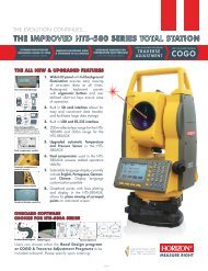
HTS 580 Series Total Station - Horizon â Measure Right
HTS 580 Series Total Station - Horizon â Measure Right
HTS 580 Series Total Station - Horizon â Measure Right

Create successful ePaper yourself
Turn your PDF publications into a flip-book with our unique Google optimized e-Paper software.
1. PREPARATION<br />
1.1 Precautions<br />
1. Never point the instrument at the sun without a filter.<br />
2. Never store the instrument in extreme temperatures and avoid<br />
sudden changes of temperature.<br />
3. When not using the instrument, place it in the case to avoid shock,<br />
dust, and humidity.<br />
4. If there is a great difference in temperature between the work site<br />
and the instrument storage location leave the instrument in the case until it<br />
adjusts to the temperature of the surrounding environment.<br />
5. Please remove the battery for separate storage if the instrument is to<br />
be in storage for an extended time. The battery should be charged once a<br />
month during storage.<br />
6. The instrument should be placed in its carrying case during<br />
transportation. It is recommended that the original packing case be used for<br />
cushioning during extended transportation.<br />
7. Be sure to secure the instrument with one hand when mounting or<br />
removing from the tripod.<br />
8. Clean exposed optical parts with degreased cotton or lens tissue<br />
only.<br />
9. Clean the instrument's surface with a woolen cloth when finished<br />
with use. Dry it immediately if it gets wet.<br />
10. Check the battery, functions, and indications of the instrument as<br />
1
well as its initial setting and correction parameters before operating.<br />
11. Unless you are a maintenance specialist do not attempt to<br />
disassemble the instrument for any reason. Unauthorized disassembly of<br />
the instrument can result in a void warranty.<br />
12. The total stations emit a laser during operation. DO NOT stare into<br />
the beam or laser source when instrument is operation.<br />
2
1.2 Nomenclature<br />
3
1.3 Unpacking and Storage of the Instrument<br />
Unpacking of the Instrument<br />
Place the case lightly with the cover upward, unlock the case and take<br />
out the instrument.<br />
Storage of the Instrument<br />
Replace the cover on the telescope lens, place the instrument into the<br />
case with the vertical clamp screw and circular vial upward (objective lens<br />
toward the tribrach), tighten the vertical clamp screw, close and lock the<br />
case.<br />
1.4 Instrument Set Up<br />
Mount the instrument onto the tripod and secure firmly. Level and<br />
center the instrument precisely to ensure the best performance. Use a<br />
rugged tripod with a 5/8” tripod screw. Our Fiberglass SL180FGB tripods<br />
are highly recommended.<br />
Operation Reference: Leveling and Centering the Instrument<br />
1). Setting up the tripod<br />
First extend the extension legs to suitable length and tighten the<br />
screws, firmly plant the tripod in the ground over the point of beginning.<br />
2). Attaching the instrument to the tripod<br />
Secure the instrument carefully on the tripod and slide the instrument<br />
by loosening the tripod mounting screw. If the optical plumb site is<br />
positioned over the center of the point tighten the mounting screw.<br />
5
3). Roughly leveling the instrument by using the circular vial<br />
Turn the leveling screw A and B to move the bubble in the circular vial,<br />
in which case the bubble is located on a line perpendicular to a line running<br />
through the centers of the two leveling screw being adjusted. Turn the<br />
leveling screw C to move the bubble to the center of the circular vial.<br />
Recheck the position of the instrument over the point and adjust if needed.<br />
4). Leveling by using the plate vial<br />
Rotate the instrument horizontally by loosening the <strong>Horizon</strong>tal Clamp<br />
Screw and place the plate vial parallel with the line connecting leveling<br />
screws A and B, then bring the bubble to the center of the plate vial by<br />
turning the leveling screws A and B.<br />
Rotate the instrument 90° (100g) around its vertical axis and turn the<br />
remaining leveling screw or leveling C to center the bubble once more.<br />
Repeat the procedures for each 90° (100g) rotation of the instrument<br />
and check whether the bubble is correctly centered in all directions.<br />
5). Centering by using the optical plummet(or laser plumment)<br />
Adjust the eyepiece of the optical plummet telescope to your eyesight.<br />
Slide the instrument by loosening the tripod screw; place the point on the<br />
center mark of the optical plummet. Sliding the instrument carefully as to not<br />
rotate the axis will allow you to get the least dislocation of the bubble.(Place<br />
star-key after power on, then press F4(LASER)key, press F1(ON)key to turn<br />
on the laser plumment. Slide the instrument by loosening the tripod screw;<br />
Place laser facular on the occupied pointing, Sliding the instrument carefully<br />
as to not rotate the axis will allow you to get the least dislocation of the<br />
bubble. The last, press ESC key, and laser plummet turn off automatically.)<br />
6
6). Complete leveling the instrument<br />
Level the instrument precisely as in Step 4. Rotate the instrument and<br />
check to see that the bubble is in the center of the plate level regardless of<br />
the telescope direction then tighten the tripod screw firmly.<br />
1.5 Battery Removal & Insertion - Information and<br />
Recharging<br />
Battery removal & insertion<br />
Insert the battery into the battery slot and push the battery until it clicks.<br />
Press the right and left buttons of the battery compartment to remove<br />
the battery.<br />
Battery information<br />
------------- Indicates that battery is fully charged<br />
------------- Indicates that the battery can only be used for about<br />
1 hour.<br />
Recharge the battery or prepare a recharged<br />
battery for use.<br />
------------- Recharge the battery or prepare a recharged<br />
7
attery for use.<br />
Note: The working time of the battery is determined by environment<br />
conditions, recharging time, and other factors.<br />
Battery Recharging<br />
Battery should be recharged only with the charger supplied with the<br />
instrument.<br />
Remove the on-board battery from instrument as instructed and<br />
connect to the battery charger.<br />
Battery Removal Caution<br />
▲Before you take the battery out of the instrument, make sure that the<br />
power is turned off. Otherwise the instrument can be damaged.<br />
Recharging Caution:<br />
▲The charger has built-in circuitry for protection from overcharging.<br />
However, do not leave the charger plugged into the power outlet after<br />
recharging is completed.<br />
▲Be sure to recharge the battery at a temperature of 0℃~45℃,<br />
recharging may be abnormal beyond the specified temperature range.<br />
▲When the indicator lamp does not light after connecting the battery<br />
and charger the battery or the charger may be damaged.<br />
Storage Caution:<br />
▲The rechargeable battery can be repeatedly recharged 300-500 times.<br />
Complete discharge of the battery may shorten its service life.<br />
▲In order to get the maximum service life be sure to recharge the<br />
battery at least once a month.<br />
8
1.6 Reflector Prisms<br />
When doing distance measuring in prism mode a reflector prism<br />
needs to be placed as the target. Reflector systems can be single or<br />
multiple prisms which can be mounted with a tripod/tribrach system or<br />
mounted on a prism pole. Unique mini prism systems allow setups at<br />
corners that are hard to reach. Reflectorless targets extend the range of the<br />
instrument when used in reflectorless mode.<br />
Illustrated are some prisms and a reflector compatible with<br />
instruments:<br />
9
1.7 Mounting and Dismounting the Instrument from the<br />
Tribrach<br />
Dismounting<br />
When necessary the instrument can be dismounted from the tribrach.<br />
Loosen the tribrach locking screw in the locking knob with a screwdriver if<br />
necessary. Turn the locking knob 180 degrees counter-clockwise to<br />
disengage anchor jaws and remove the instrument from the tribrach.<br />
10
Mounting<br />
Insert three anchor jaws into holes in tribrach and line up the directing<br />
stub on the instrument with the directing slot of the tribrach. Turn the locking<br />
knob 180 degrees clockwise and tighten the locking screw with a<br />
screwdriver.<br />
1.8 Eyepiece Adjustment and Object Sighting<br />
Method of Object Sighting (for reference)<br />
Sight the telescope to the sky and rotate the eyepiece tube to make the<br />
reticule clear.<br />
Collimate the target point with top of the triangle mark in the collimator.<br />
(keep a certain distance between eye and the collimator).<br />
Make the target image clear with the telescope focusing screw.<br />
If there is parallax when your eye moves up and down or left and right<br />
this indicates the diopter of the eyepiece lens or focus is not adjusted well<br />
and accuracy will be effected. You should readjust the eyepiece tube<br />
carefully to eliminate the parallax.<br />
1.9 Turning the instrument On and Off<br />
Power on<br />
1. Be sure that the instrument is leveled.<br />
2. Press and momentarily hold the power (POWER) key.<br />
11
3. Rotate the EDM head in an upwards direction to initialize.<br />
4. To turn OFF press and hold the power key until instrument powers<br />
down.<br />
Be sure there is sufficient battery power. If 'Battery Empty' is shown on<br />
the display, the battery should be recharged or replaced.<br />
*** DO NOT remove the battery during measuring, otherwise the data will be<br />
lost and the instrument could be harmed!! ***<br />
1.10 How To Enter Alphanumeric Characters<br />
*How to select an item<br />
[Example 1] Select INS.HT (instrument height) in the data collection<br />
mode (first press the MENU button then F1:DATA COLLECT and then<br />
select the data file desired. Press F2 to list, the arrow keys to choose and<br />
then F4 to select). Press F1 again for OCC.PT# INPUT.<br />
The arrow (→) indicates an item to enter. Press [▲] [▼] key to move the<br />
arrow line up or down<br />
Press [▼] move->R..HT<br />
12
Press F1 INPUT then 1 to input“1”<br />
Press . to input “. ”<br />
Press 5 to input “5 ”, press ENT<br />
Then R. HT =1.5 m<br />
*How to enter characters<br />
[Example 2] Input the code “ABC1”of instrument point in Data Collection<br />
Mode.<br />
1.Move the arrow to PCODE using the [▲]or [▼]key<br />
2.Press F1 (input) key<br />
13
3.Press F1 key once<br />
Press [7] key once for “A”<br />
Press [7] key twice for “B”<br />
Press [7] key three times for “C”<br />
Press [1] key once for “1” (*Press F3 to switch to NUMB mode first)<br />
Press enter key to finish input<br />
2. FUNCTION KEY AND DISPLAY<br />
2.1 Operating Key<br />
Keys Names Function<br />
14
ANG Angle meas. key Angle measurement mode<br />
Distance meas. key<br />
Coordinate meas.<br />
key<br />
Distance measurement mode<br />
Coordinate measurement mode<br />
( Up)<br />
S.O Layout key Layout measurement mode (<br />
Down)<br />
K1 Quick key1 User-defined quick key 1( Left)<br />
K2 Quick key 2 User-defined quick key 2( <strong>Right</strong>)<br />
ESC Escape key Return to the measurement mode or<br />
previous layer mode.<br />
ENT Enter key Press after confirmation of inputting<br />
values<br />
M Menu key Switches menu mode and normal<br />
mode<br />
T Shift key Shift distance measuring key<br />
Star key<br />
Power key<br />
F1- F4 Soft key ( Function<br />
key)<br />
Press once to adjust contrast or twice<br />
for illumination of keypad<br />
On / Off key press and hold<br />
0- 9 Number key Input numbers<br />
Responds to the message displayed<br />
— Minus key Input minus sign, displays electronic<br />
bubble<br />
. Point key On / Off laser pointing function<br />
Display marks:<br />
Display<br />
V<br />
Vertical angle<br />
Content<br />
15
V% Vertical angle as a percentage (Gradient display)<br />
HR <strong>Horizon</strong>tal angle (right)<br />
HL <strong>Horizon</strong>tal angle (left)<br />
HD <strong>Horizon</strong>tal distance<br />
VD Elevation difference<br />
SD Slope distance<br />
N North coordinate<br />
E East coordinate<br />
Z Z or elevation coordinate<br />
* EDM working<br />
m/ft Switches units between meters and feet<br />
m Meter unit<br />
S/A Sets temperature, air pressure, prism constant<br />
PSM<br />
PPM<br />
Prism constant (unit:mm)<br />
Atmospheric correction<br />
2.2 Function Key<br />
Angle measurement mode (three -page menu)<br />
16
Page<br />
P1<br />
Keys<br />
Display<br />
marks<br />
Function<br />
F1 0SET <strong>Horizon</strong>tal angle is set to 0°0′0″<br />
F2 HOLD Hold the horizontal angle<br />
F3 HSET Set a required horizontal angle by entering<br />
numbers<br />
F4 P1↓ Scroll to the next page (P2)<br />
P2 F1 TILT<br />
P3<br />
F2<br />
Tilt correction screen. If the correction is<br />
turned on the display will show the tilt<br />
correction value.<br />
F3 V% Vertical angle percent grade (%) mode<br />
F4 P2↓ Scroll to the next page (P3)<br />
F1 R/L Switches <strong>Right</strong>/Left rotation of horizontal<br />
F2<br />
angle<br />
F3 CMPS Switches vertical angle “0” position<br />
F4 P3↓ Scroll to the next page (P1)<br />
17
Distance measurement mode (two-page menu)<br />
Page Keys Display marks Function<br />
F1 MEAS Begin measuring<br />
P1 F2 MODE Sets measuring mode,<br />
Fine/--/Tracking<br />
F3 S/A Sets temperature, air pressure, prism<br />
constant<br />
F4 P1↓ Scroll to the next page (P2)<br />
F1 OFSET Selects Off-set measurement mode<br />
P2 F2 S.O. Selects Stake Out measurement<br />
mode<br />
F3 m / ft Switches units between meters and<br />
feet<br />
F4 P2↓ Scroll to the next page (P1)<br />
18
Coordinate measurement mode(three-page menu)<br />
19
2.3 star-key mode<br />
The total station(non-reflectorless):<br />
Press the star key , following is displayed:<br />
Page Keys Display<br />
Function<br />
marks<br />
F1 MEAS Start measuring<br />
P1 F2 MODE Sets a measuring mode, Fine/Tracking<br />
F3 S/A Sets temperature, air pressure, prism<br />
constant<br />
F4 P1↓ The function of soft keys is shown on<br />
next page (P2)<br />
F1 R.HT Sets prism height<br />
P2 F2 INSHT Sets instrument height<br />
F3 OCC Sets instrument coordinate.<br />
F4 P2↓ Shows the function of soft keys on page<br />
3<br />
F1 OFSET Off-set measurement mode<br />
F2 BACKSIGHT Setting a direction angle for backsight<br />
P3<br />
orientation<br />
F3 m / ft Switches meter and feet unit.<br />
20<br />
F4 P3↓ Shows the function of soft keys on<br />
page1
1. Contrat adjustment: After pressing star key, adjust the display<br />
contrast by pressing [▲] or [▼] key.<br />
2. Illumination: After pressing star key, select [Illumination] by pressing<br />
F1(LAMP) key or press star key.<br />
3. Tilt: After pressing star key, select [tilt] by pressing F2 (TILT) key,<br />
and select ON or OFF by pressing F1 or F3 key, press F4 (ENT) key.<br />
4. S/A: After pressing star key, select [S/A] by pressing F3 (S/A) key,<br />
then you can set Prism contrast, air pressure and temperature.<br />
5. Laser plumment: If total station has this function, after pressing star<br />
key, select [laser] by pressing F4 (LASR) key, and select ON or OFF by<br />
pressing F1 or F2 key.<br />
*In some interface, you can turn on or turn off panel backlight by press<br />
star key directly.<br />
The total station(with reflectorless):<br />
Press the star key , following is displayed:<br />
1.Mode: Press the F1 (mode) key, the following is displayed :<br />
21
You can select the type of measure mode by pressing the F1—F3<br />
keys.<br />
2.You can turn on the lamp by pressing the star key once more or by<br />
pressing twice from any menu.<br />
2.4 Dot-key Mode<br />
The total station can function as a laser pointer<br />
The laser pointer can be turned on or off by pressing the (.) dot key.<br />
3. INITIAL SETTINGS<br />
The series total station can be reset to the instruments original factory<br />
settings.<br />
See Section 11 “Basic Settings”<br />
3.1 Setting the Temperature and Atmospheric<br />
Pressure<br />
22<br />
<strong>Measure</strong> the surrounding temperature and air pressure in advance.
Example: temperature +25°, air pressure 1017.5 hPa<br />
Procedure<br />
Operatio<br />
n<br />
Operating<br />
procedure<br />
Display<br />
Enter the Distance<br />
<strong>Measure</strong>ment<br />
Mode<br />
Press F3 to enter<br />
the S/A screen<br />
F3<br />
Press F3 to enter<br />
temperature<br />
Temp.<br />
Settings<br />
F3<br />
section, enter the<br />
correct<br />
temperature, press<br />
the ENT key to set<br />
Press F2 key and<br />
Atms.<br />
enter the air<br />
Pressur<br />
e<br />
F2<br />
pressure, press the<br />
ENT key to confirm<br />
23
ks<br />
Rema<br />
Temperature operating range:-30°~+60℃ or -22~+140℉<br />
Air pressure:560~1066 hPa or 420~800 mmHg or 16.5~31.5<br />
inHg<br />
If the atmospheric correction value calculated from the<br />
temperature and air pressure exceeds the range of ±<br />
999.9PPM,the operation will return to step 4 automatically, and<br />
you should enter the data again.<br />
3.2 Setting of the Atmospheric Correction<br />
The infrared emitted by the <strong>Total</strong> <strong>Station</strong> varies with the air temperature<br />
and pressure. Once the atmospheric correction value is set the instrument<br />
will correct the distance measuring result automatically.<br />
Air pressure:<br />
1013hPa<br />
Temperature: 20℃<br />
The calculation of atmospheric correction :<br />
ΔS =273.8 – 0.2900 P / ( 1 + 0.00366T )(ppm)<br />
ΔS:Correction Coefficient (Unit ppm)<br />
P: Air Pressure (Unit : hPa If the unit is mmHg , please convert<br />
using<br />
1hPa<br />
= 0.75mmHg<br />
T: temperature ( unit℃)<br />
Direct Setting Method of Atmosphere Correction Value<br />
After measuring the temperature and air pressure the atmosphere<br />
24
correction value can be obtained from an atmospheric correction chart or<br />
correction formula (PPM).<br />
Procedur<br />
Operatio<br />
Operation Procedure<br />
Display<br />
e<br />
n<br />
Press F3 Key in<br />
F3<br />
distance<br />
measurement or<br />
coordinate<br />
measurement mode<br />
Press F2 [ppm] key,<br />
F2<br />
which shows the<br />
current setting value<br />
Enter<br />
value<br />
Enter atmospheric<br />
correction and press<br />
ENT<br />
*1)See 2.10“How to Enter Alphanumeric Characters”<br />
Input range:-999. 9PPM to +999. 9 Step length: 0 .1PPM<br />
*2)If Temperature and Atmospheric Pressure are reset, the PPM will be<br />
recalculated automatically.<br />
3.3 Setting of the Prism Constant<br />
25
In the factory the prism constant for the total station is set at -30mm. If<br />
the constant of the prism used is not -30mm, you must change this setting.<br />
Once the prism constant is set it will become the new default value until<br />
changed.<br />
Procedure Operation Operation<br />
Display<br />
F3<br />
Procedure<br />
Press F3 ( S/A )<br />
Key in Distance<br />
<strong>Measure</strong>ment<br />
Mode<br />
or Coord.<br />
<strong>Measure</strong>ment<br />
Mode.<br />
2<br />
F1<br />
2 Press F1<br />
(PRISM)key<br />
Press F1 (INPUT)<br />
key to enter the<br />
Prism Constant<br />
Enter correction value.<br />
3<br />
data *1, press F4 to<br />
confirm and return<br />
to the Setting<br />
Mode.<br />
Input range:-99. 9mm to +99. 9mm Step length 0. 1mm<br />
*The total station in reflectorless measuring mode sets the prism constant to<br />
26
0 automatically.<br />
3.4 Setting of the Vertical Angle Tilt Correction<br />
When the tilt sensor is activated the instrument automatically corrects<br />
the vertical angle for mislevel. To ensure a precise angle measurement the<br />
tilt sensor must be turned on. The tilt sensor display can also be used to fine<br />
level the instrument. If the (“X TILT OVER”) display appears the instrument<br />
is out of the automatic compensation range and must be leveled manually to<br />
within tolerances.<br />
The instruments compensates the vertical angle reading due to<br />
inclination of the standing axis in the X direction.<br />
When the instrument is on an unstable footing or used during a windy<br />
day the display of vertical angle can be unstable. You can turn off the auto<br />
tilt correction function in this case.<br />
Setting the tilt correction<br />
The instrument memorizes the last setting for this feature. To insure the<br />
compensator is on check this setting before operating the instrument.<br />
For operation procedures refer to 11.2.1.<br />
27
4.ANGLE MEASUREMENT<br />
4.1 Measuring <strong>Horizon</strong>tal Angle <strong>Right</strong> and Vertical<br />
Angles<br />
Make sure the angle measurement mode is selected.<br />
Operation procedure Operation Display<br />
1 Collimate the first<br />
target (A)<br />
Collimate A<br />
To set horizontal angle<br />
of target A at 0º<br />
F1<br />
00 ’ 00" press the F1<br />
(0SET) key and then<br />
F4<br />
press the F4 (YES) key<br />
3Collimate the second<br />
target (B)<br />
The required V/H angle<br />
Collimate B<br />
to target B will be<br />
28
displayed<br />
Note : The horizon angle will be saved when the instrument is powered off<br />
and displayed when powered on.<br />
Reference: How to Collimate<br />
Point the telescope toward a light surface or sky. Turn the diopter ring and<br />
adjust the diopter so that the cross hairs are clearly observed.<br />
Aim the target at the peak of the triangle mark of the sighting collimator.<br />
Allow a certain space between the sighting collimator and yourself for<br />
collimating.<br />
Focus the target with the focusing knob.<br />
If parallax is created between the cross hairs and the target when viewing<br />
vertically or horizontally while looking into the telescope, focusing is<br />
incorrect or diopter adjustment is poor.<br />
This adversely affects precision in measurement please eliminate the<br />
parallax by carefully focusing and using the diopter adjustment.<br />
29
4.2 Switching <strong>Horizon</strong>tal Angle <strong>Right</strong>/Left<br />
Make sure the angle measurement mode is selected.<br />
Operation procedure Operation Display<br />
Press the F4 Key twice to get<br />
the menu to page 3. (P3)<br />
F4<br />
twice<br />
Press the F1(R/L)key.<br />
The <strong>Horizon</strong>tal <strong>Right</strong> angle<br />
mode (HR) Switches to<br />
F1<br />
<strong>Horizon</strong>tal Left mode (HL)<br />
<strong>Measure</strong> as HL mode<br />
30
*Each time the F2 (R/L) key is pressed the HR/HL mode switches<br />
4.3 Setting of the <strong>Horizon</strong>tal Angle<br />
4.3.1 Setting by Holding the Angle<br />
Make sure the angle measurement mode is selected.<br />
Operation procedure Operation Display<br />
1 Set the required<br />
horizontal angle using the<br />
horizontal tangent screw<br />
Display<br />
angle<br />
2Press the F2 (HOLD)key<br />
F2<br />
3Collimate the target<br />
Collimate<br />
31
4Press the F4 (YES) key<br />
to finish holding the<br />
horizontal angle, the<br />
display turns back to the<br />
F4<br />
normal<br />
angle measurement mode<br />
*To return to the previous mode, press the ESC key.<br />
4.3.2 Setting the <strong>Horizon</strong>tal Angle from the Keypad<br />
Make sure the angle measurement mode is selected.<br />
Operation procedure Operation Display<br />
1Collimate the target<br />
Collimate<br />
2Press the F3 (HSET) key<br />
F3<br />
32
3 Input the required<br />
horizontal angle by using<br />
the keys, for example:<br />
150.10.20, inputs<br />
150º10′20″.<br />
Press ENT<br />
150.10.20<br />
ENT<br />
Carry on normal<br />
measurement after entering<br />
the required horizontal<br />
angle<br />
4.4 Vertical Angle Percent Grade (%) Mode<br />
Make sure the angle measurement mode is selected.<br />
Operation procedure Operation Display<br />
Press F4 key to get<br />
the function on menu<br />
F4<br />
page P2<br />
Press the F3(V%)key<br />
*<br />
F3<br />
33
*Each time the F3(V%)key is pressed the display mode switches.<br />
When the angle measured is over 45°(100%)from the horizontal<br />
is displayed.<br />
4.5 Setting the Initial Zenith Angle<br />
Vertical angle is displayed as shown below:<br />
Make sure the angle measurement mode is selected.<br />
34<br />
Operation procedure Operation Display
Press F4 key twice to get the<br />
menu on page 3 (P3):<br />
F4<br />
twice<br />
Press the F3(CMPS)key *<br />
F3<br />
* Each time the F3 key is pressed the display mode switches.<br />
5. DISTANCE MEASUREMENT<br />
When setting the atmospheric correction obtain the correction value by<br />
measuring the temperature and pressure.<br />
5.1 Setting of the Atmospheric Correction<br />
When setting the atmospheric correction obtain the correction value by<br />
measuring the temperature and pressure. Refer to Section 3.2 “Setting of<br />
the Atmospheric Correction”.<br />
5.2 Setting of the Correction for Prism Constant<br />
The instrument is preset for a Prism Constant value of -30mm at the<br />
factory. If the prism is of another constant the instrument needs to be<br />
35
updated with this constant. Refer to Chapter 3.3 “Setting of the Prism<br />
Constant”. The updated value is kept in the instrument memory after the<br />
power is shut off.<br />
5.3 Distance <strong>Measure</strong>ment (Continuous <strong>Measure</strong>ment)<br />
Make sure the angle measurement mode is selected.<br />
Operation procedure Operation Display<br />
Collimate the center of<br />
prism *1<br />
Collimate<br />
Press the<br />
key,<br />
distance measurement<br />
starts *2 *3;<br />
3The measured distances<br />
are shown (*4,*7) By<br />
pressing the key again<br />
the display changes to<br />
horizontal (HR), vertical (V)<br />
angle, vertical distance (VD)<br />
and slope distance (SD)<br />
36
*1 ) The total station prism mode collimate center of prism when<br />
measuring;<br />
*2)When EDM is working, the “*” mark appears in the display. The total<br />
stations will display “weak signal” when measuring if the signal is weak.<br />
*3)To change the mode from Fine to Tracking, refer to section 5.4 “Fine<br />
mode / Tracking Mode”. To set the distance measurement on when the<br />
instrument is powered up, refer to Chapter 11 “Basic Settings”.<br />
*4)The distance unit indicator "m" (for meter) or “ft” (for feet) appears<br />
and disappears alternatively with a buzzer sounding at every renewal of<br />
distance data.<br />
*5) <strong>Measure</strong>ment may repeat automatically in the instrument if the result<br />
is affected by external factors*.<br />
*6 ) To return to the angle measuring angle mode from the<br />
distance-measuring mode, press the ANG key.<br />
*7)It is possible to choose the display order (HR,HD,VD) or (V, HR,SD) for<br />
initial measuring mode. Refer to Chapter 11 "Basic Settings".<br />
5.4 Changing the Distance <strong>Measure</strong>ment Mode<br />
(Repeat <strong>Measure</strong>ment / Single <strong>Measure</strong>ment/<br />
Track <strong>Measure</strong>ment)<br />
Make sure the angle measurement mode is selected.<br />
Operation procedure Operatio<br />
n<br />
Display<br />
37
Collimate the center of the<br />
prism<br />
Collimat<br />
e<br />
Press the key ,<br />
Continuous<br />
<strong>Measure</strong>ment begins *1;<br />
Press the F2 (MODE) key to<br />
switch between Repeat<br />
<strong>Measure</strong>ment, Single<br />
<strong>Measure</strong>ment and Tracking<br />
F2<br />
F1<br />
<strong>Measure</strong>ment. [N], [1], [T]<br />
*1 It is possible to set the measurement mode for N-times measuring<br />
mode or continuous measurement mode when the power is turned on.<br />
Refer to Chapter 11 “Basic Settings”.<br />
5.5 Stake Out (S.O.)<br />
38
The difference between the measured distance and the input stake out<br />
distance is displayed.<br />
<strong>Measure</strong>d distance - Stake out distance = Displayed value<br />
In a stake out operation you can select either horizontal distance (HD),<br />
relative elevation (VD), and slope distance (SD.)<br />
Operation procedure Operation Display<br />
Press the<br />
F4( ↓ ) key in the<br />
distance measuring mode to<br />
F4<br />
menu P2<br />
Press the F2 (S.O) key<br />
The data previously set is<br />
F2<br />
shown<br />
Select the measuring mode by<br />
pressing the F2 to F4 keys.<br />
F1<br />
F2:HD, F3:VD,<br />
F4:SD<br />
39
Enter the distance 350 , press<br />
F4<br />
Enter 350<br />
F4<br />
Collimate the target (Prism),<br />
measurement starts. The<br />
difference<br />
between the measured distance<br />
and the<br />
stake out distance is displayed.<br />
Collimate<br />
Pris<br />
m<br />
Move the target until the<br />
difference becomes 0.<br />
To return to normal distance measurement mode, stake out distance to “0”<br />
or switch to other measurement mode.<br />
5.6 Offset <strong>Measure</strong>ment<br />
There are four offset measurement modes:<br />
1. Angle offset<br />
40
2. Distance offset<br />
3. Plane offset<br />
4. Column offset<br />
5.6.1 Angle Offset<br />
This mode is useful when it is difficult to set up the prism directly on<br />
target; for example at the center of a tree. Place the prism at the same<br />
horizontal distance from the instrument as that of point A0 to measure. To<br />
measure the coordinates of the center position use the offset measurement<br />
after setting the instrument height/prism height.<br />
When measuring coordinates of ground point AI: Set the instrument<br />
height/Prism height<br />
When measuring coordinates of point A0: Set the instrument height<br />
only (Set the prism height to 0)<br />
41
Set the instrument height/prism height before proceeding to the offset<br />
measurement mode.<br />
When setting the coordinate value for the occupied station, refer to<br />
Section 6.2 “Setting Coordinate Values of an Occupied Point”.<br />
Operation procedure Operation Display<br />
Press the F4( ↓ ) key from<br />
distance<br />
F4<br />
measuring mode to get the<br />
function on menu P2<br />
Press F1 (OFSET) key<br />
F1<br />
Press F1 (ANG.OFFSET) key<br />
F1<br />
42
Collimate prism P, and press<br />
the F1<br />
(MEAS) key.<br />
The horizontal distance from<br />
the instrument to the prism<br />
will be measured.<br />
Collimate<br />
[P]<br />
F1<br />
Collimate point AO using the<br />
horizontal motion clamp<br />
and horizontal tangent screw.<br />
Collimate<br />
AO<br />
Show the north coordinate,<br />
east coordinate and z<br />
coordinate of waited<br />
measuring point by pressing<br />
key.<br />
To return to procedure 3, press F4 (NEXT) key<br />
To return to the previous mode, press ESC key<br />
5.6.2 Distance Offset <strong>Measure</strong>ment<br />
Measuring the distance and coordinate of a pond or a tree of which the<br />
radius is known. Measuring the distance or coordinate to P0 point, input<br />
oHD value as an offset value and measure P1 point as shown in the<br />
43
drawing. The display shows distance or coordinate value to P0 point.<br />
When setting the coordinate value for the occupied station, refer to Section<br />
6.2 ‘Setting Coordinate of Occupied Point’<br />
Operation procedure Operation Display<br />
1Press the F4 (↓) key from<br />
distance measuring mode to<br />
F4<br />
get the function on menu P2<br />
2Press F1 (OFSET) key.<br />
F1<br />
3 Press F2 (DIST OFSET)<br />
key, enter the measurement<br />
F2<br />
of DIST.OFFSET<br />
44
4Enter R HD,<br />
press ENT key *1<br />
Enter R<br />
HD<br />
Enter<br />
ENT<br />
5Enter forward HD,<br />
press ENT key *2<br />
forward<br />
HD<br />
ENT<br />
6 Collimate Prism P1, and<br />
press F1 (MEAS) key.<br />
Measuring will start.<br />
After measuring, the result<br />
Collimate<br />
P1<br />
F1<br />
added<br />
offset value will be show。<br />
7 Show the coordinate of<br />
Point P0<br />
To return to procedure 4,press F1 (NEXT) key<br />
To return to the previous mode, press ESC key<br />
*1)*2)refer to section 8.3.2 “Distance Offset <strong>Measure</strong>ment”<br />
45
5.6.3 Plane Offset <strong>Measure</strong>ment<br />
Used to facilitate distance or coordinate measuring for a given plane.<br />
Three random prism points (P1, P2, P3) on a plane will be measured at first<br />
in the plane-offset measurement to determine the measured plane.<br />
Collimate the measuring target point (P0) then the instrument will calculate<br />
and display coordinate and distance values of the cross point between<br />
collimation axis and the plane.<br />
When setting the coordinate value for the occupied station, refer to Section<br />
7.2 ‘Setting Coordinate Value of Occupied Point’.<br />
Operation procedure Operation Display<br />
1Press the F4 (↓) key from<br />
distance<br />
F4<br />
measuring mode to get the<br />
function on page 2.<br />
46
2Press F1 (OFSET) key<br />
F1<br />
3Press F3 (PLANE OFSET)<br />
key<br />
F3<br />
4 Collimate Prism P1, and<br />
press F1 (MEAS) key.<br />
N-time measuring will start.<br />
After measuring, the display<br />
will show the second point<br />
measurement.<br />
Collimate<br />
P1<br />
F1<br />
47
5<strong>Measure</strong> the second and<br />
third points in the same way.<br />
The instrument calculates<br />
Collimate<br />
P2<br />
F1<br />
and displays coordinate and<br />
distance values of the cross<br />
point between the collimation<br />
axis and of the plane *1*2<br />
Collimate<br />
P3<br />
F1<br />
6Collimate the edge (P0) of<br />
the plane *3*4<br />
Collimate<br />
P0<br />
7 By pressing key<br />
each time , horizontal<br />
distance, relative elevation<br />
and slope distance are<br />
shown in sequence.<br />
To show the coordinate of<br />
the point (P0), press<br />
key.<br />
48
*1 ) In case the calculation of plane was not successful by the measured<br />
three points, error displays. Start measuring over again from the first point.<br />
*2 ) Data display is the mode beforehand of offset measurement mode.<br />
*3 ) Error will be displayed when collimated to the direction which does not<br />
cross with determined plane.<br />
*4 ) The reflector height of the target point P0 is set to zero automatically.<br />
5.6.4 Column Offset <strong>Measure</strong>ment<br />
If it is possible to measure circumscription point (P 1) of Column<br />
directly the distance to the center of the column (P0), coordinate and<br />
direction angle can be calculated by measured circumscription points (P2)<br />
and (P3).<br />
The direction angle of the center of the column is 1/2 of total direction<br />
angle of circumscription points (P2) and (P3).<br />
49
When setting the coordinate value for the occupied station, refer to<br />
Section 6.2 ‘Setting Coordinate Values of Occupied Point’.<br />
Operation procedure Operation Display<br />
Press the F4 (↓) key<br />
from distance<br />
measuring mode to get<br />
the function on menu P2<br />
F4<br />
Press F1 (OFSET) key<br />
F1<br />
Press F4 (COLUMN<br />
OFFSET)key<br />
F4<br />
50<br />
Collimate the center of<br />
the column<br />
(P1) and press F1<br />
(MEAS) key<br />
N-time measuring will<br />
start.<br />
After the measurement,<br />
angle-measuring display<br />
of the left side (P2) will<br />
be shown.<br />
Collimate<br />
P1<br />
F1
Collimate the left side of<br />
column(P2) and press<br />
F4 (SET) key.<br />
Collimate<br />
After<br />
measurement,<br />
P2<br />
angle measuring<br />
F4<br />
display of the right side<br />
(P3) will be shown.<br />
6Collimate the right side<br />
of the column (P3) and<br />
press F4 (SET) key.<br />
After measurement, the<br />
distance between the<br />
instrument and the<br />
center of column (P0) will<br />
be calculated.<br />
Collimate<br />
P3<br />
F4<br />
To show the coordinate<br />
of point P0,press<br />
key. *1*2<br />
*1)To return to procedure 5, press F4 (NEXT) key<br />
*2)To escape the measuring,press ESC key,the display returns to the<br />
previous mode.<br />
51
6. COORDINATE MEASUREMENT<br />
6.1 Execution of Coordinate <strong>Measure</strong>ment<br />
<strong>Measure</strong> the coordinates by entering the instrument height and prism<br />
height, coordinates of unknown Point will be measured directly.<br />
* When setting coordinate values of occupied point, see Section 6.2<br />
“Setting Coordinate Values of Occupied <strong>Station</strong> Point”.<br />
* When setting the instrument height and prism height, see Section 6.3<br />
“Setting Height of the Instrument” and 6.4 “Setting Height of Target (prism<br />
Height)”.<br />
* To set backsight, determine the backsight azimuth or check the<br />
known azimuth, coordinate and distance.<br />
The coordinates of the unknown point are calculated as shown below and<br />
displayed:<br />
Coordinates of occupied point:(N0,E0,Z0)<br />
Instrument height :INS.HT<br />
Prism height: R.HT<br />
Vertical distance (Relative elevation):Z(VD)<br />
Coordinates of the center of the prism, originated from the center point<br />
of the instrument:(n,e,z)<br />
Coordinates of unknown point:(N1,E1,Z1)<br />
N1=N0+n<br />
E1=E0+e<br />
Z1=Z0+INS.HT+Z-R.HT<br />
Center point of the instrument (N0, E0, Z0+INS.HT)<br />
52
When doing coordinate measurement coordinates of occupied point, the<br />
instrument height, the prism height and back sight azimuth should be set.<br />
Operation procedure Operation Display<br />
Set the direction angle of<br />
known<br />
point A *1 )<br />
Set<br />
direction<br />
angle<br />
Collimate target prism B,<br />
and press<br />
key<br />
e<br />
Collimat<br />
target<br />
prism<br />
*1Refer to Section 4.3 “Setting of <strong>Horizon</strong>tal Angle”.<br />
In case the coordinate of instrument point is not entered, (0,0,0) will be<br />
used as the default for the instrument point. The prism height will be<br />
53
calculated as 0 when the prism height is not set.<br />
6.2 Setting Coordinate Values of Occupied Point<br />
Set the coordinates of the instrument (occupied point) ac cording to<br />
known values and the instrument automatically converts and displays the<br />
unknown point (prism point) coordinates following the observation.<br />
The instrument retains the coordinates of the occupied point after<br />
turning the power off.<br />
54
Operation procedure Operation Display<br />
Press the F4 (P1↓) key<br />
from the<br />
coordinate<br />
measurement<br />
F4<br />
mode to get the function on<br />
menu P2.<br />
Press the F3(OCC)key<br />
F3<br />
Enter<br />
3Enter N coordinate value<br />
data<br />
ENT<br />
55
4Enter E and Z coordinate<br />
values in the same manner.<br />
After entering the<br />
values, the display returns<br />
to the coordinate measuring<br />
data<br />
Enter<br />
ENT<br />
display menu.<br />
Input range:-999999.999m/ft ≤ N、E、Z ≤ +999999.999m/ft<br />
6.3 Setting Height of the Instrument<br />
The instrument height value will be retained after the instrument is powered<br />
off.<br />
Operation procedure Operation Display<br />
Press the F4 (P1↓) key from<br />
the coordinate measurement<br />
F4<br />
mode to access the P2 menu<br />
screen.<br />
56
2 Press the F2 (I.HT) key,<br />
The current value is displayed.<br />
F2<br />
Enter the instrument height<br />
and press the ENT key to get<br />
to the coordinate measuring<br />
display<br />
Enter the<br />
I.H.<br />
ENT<br />
Input range:<br />
—999.999≤INS.HT≤+999.999m<br />
6.4 Setting Height of Target (Prism Height)<br />
This mode can be used to obtain z coordinate values. The target height<br />
value will be retained after the instrument is powered off.<br />
Operation procedure Operation Display<br />
Press the F4 (P1↓) key from<br />
the<br />
coordinate<br />
measurement<br />
F4<br />
mode to access the P2 menu<br />
screen.<br />
57
2Press the F1 (R.HT) key<br />
The current value is displayed.<br />
F1<br />
Enter the prism height, then<br />
Enter the<br />
press the<br />
ENT key to get<br />
prism<br />
to the coordinate measuring<br />
display<br />
height<br />
ENT<br />
Input range:<br />
—999.999m≤prism height≤+999.999m/ft<br />
7. SURVEYING PROGRAM<br />
Surveying Program Mode (programs)<br />
By pressing the menu key M , the instrument will be in Menu Mode.<br />
7.1 Remote Elevation <strong>Measure</strong>ment(REM)<br />
To obtain elevation of the point at which setting the target prism is not<br />
possible, place the prism at any point on the vertical line from the target then<br />
carry out REM procedure as follows.<br />
58
1)With prism height (h) input<br />
Operation procedure Operation Display<br />
Press the M Key<br />
M<br />
59
Press the F2 key , enter<br />
MEAS PROGRAM. menu<br />
F2<br />
3Press the F1(REM)key<br />
F1<br />
4Press the F1 key<br />
F1<br />
5Enter prism height (1.3 is<br />
an example in meters)<br />
F1<br />
Enter<br />
prism<br />
height<br />
1.3<br />
F4<br />
6Collimate prism<br />
Collimate<br />
Prism<br />
7 Press the F1 (MEAS)<br />
key, measurement starts.<br />
F1<br />
60
<strong>Horizon</strong>tal distance<br />
(HD)<br />
between the instrument and<br />
prism will be shown.<br />
8Press the F4 (SET)<br />
The prism position will be<br />
F4<br />
decided.<br />
9 Collimate target K.<br />
Vertical distance<br />
(VD) will be shown.<br />
Collimate<br />
K<br />
To return to procedure 5,press F2 (R.HT) key.<br />
To return to procedure 6,press F3 (HD) key.<br />
To return to PROGRAMS Menu, press the ESC key.<br />
2)Without prism height input<br />
Operation procedure Operation Display<br />
61
Press the M menu key<br />
M<br />
Press the F2 key,enter the<br />
measure programs menu.<br />
F2<br />
3Press the F1 (REM) Key.<br />
F1<br />
4 Press the F2 key to<br />
select the mode without<br />
prism height.<br />
Collimate prism, press the<br />
F1 (MEAS) key. Measuring<br />
starts. <strong>Horizon</strong>tal distance<br />
(HD) between the<br />
instrument and target will be<br />
shown..<br />
F2<br />
Collimate<br />
target<br />
62
6Press the F4 (SET)<br />
The target position will be<br />
F4<br />
decided.<br />
Collimate ground point G ,<br />
press the F4 (SET) key.<br />
F4<br />
The position of<br />
point G will be decided<br />
Collimate target K<br />
Vertical distance (VD) will<br />
be shown<br />
Collimate<br />
K<br />
To return to procedure 5, press the F3 (HD) key.<br />
To return to procedure 6, press the F2 (V) key.<br />
To return to PROGRAMS Menu, press the ESC key.<br />
7.2 Missing Line <strong>Measure</strong>ment (MLM)<br />
<strong>Measure</strong>ment for horizontal distance (dHD) , slope distance<br />
(dVD),elevation (dVR) a nd horizontal bearing (HR) between two target<br />
prisms.<br />
It is possible to enter the coordinate value directly or calculate from<br />
coordinate data file.<br />
MLM Mode has two modes:<br />
63
1. MLM-1 (A-B, A-C): <strong>Measure</strong>ment A-B, A-C, A-D<br />
2. MLM-2 (A-B, B-C): <strong>Measure</strong>ment A-B, B-C, C-D<br />
It is necessary to set the direction angle of the instrument.<br />
[Example] MLM-1 (A-B, A-C)<br />
Procedure of MLM-2(A-B,B-C)mode is completely the same as that<br />
of MLM-1 mode.<br />
Operation procedure Operation Display<br />
1Press the M menu key<br />
M<br />
64
2Press the F2 key, enter<br />
MEAS PROGRAMS<br />
F2<br />
3Press the F2 (MLM) key<br />
F2<br />
4Enter file name<br />
Enter file<br />
name<br />
5Press ENT key.<br />
ENT<br />
6Press the F1 key<br />
F1<br />
65
7 Collimate prism A, and<br />
press the F1 (MEAS) key.<br />
Collimate<br />
<strong>Horizon</strong>tal<br />
distance (HD)<br />
A<br />
between the instrument and<br />
F1<br />
target A will be shown.<br />
8Press the F4 (SET) key<br />
The position of the target is<br />
F4<br />
confirmed.<br />
9 Collimate prism B and<br />
press the F1 (MEAS) key.<br />
Collimate<br />
<strong>Horizon</strong>tal<br />
distance (HD)<br />
B<br />
between the instrument and<br />
F1<br />
target B will be shown..<br />
10Press the F4 (SET) key<br />
The<br />
horizontal<br />
distance(dHD) and relative<br />
F4<br />
elevation (dVD)<br />
between<br />
target A and B.<br />
⑾To measure the distance<br />
between points<br />
A and C, press the<br />
(NEXT) key*1)<br />
F4<br />
F4<br />
66
⑿ Collimate point C (target<br />
C) and press the F1<br />
(MEAS) key.<br />
<strong>Horizon</strong>tal distance (HD)<br />
between the instrument and<br />
Collimate<br />
C<br />
F1<br />
target C will be shown.<br />
⒀Press the F4 (SET) key.<br />
The horizontal distance<br />
(dHD) and relative elevation<br />
F4<br />
(dvD) between taget A and<br />
C will be shown<br />
⒁To measure the distance<br />
between points<br />
A and D, repeat procedure<br />
12 to 14 *<br />
*To return to Previous mode , press the ESC key.<br />
67
HOW TO USE COORDINATE DATA<br />
It is possible to input coordinate values directly or calculate from a<br />
coordinate data file.<br />
[Example] Input the data (NEZ) directly:<br />
Operation procedure Operation Display<br />
1Press the F3(NEZ) key<br />
F3<br />
68
2 Press the<br />
F4(coordinate) key<br />
F4<br />
3Enter coordinate, press<br />
ENT key to get to the<br />
ENT<br />
second point.<br />
*To return to PROGRAMS Menu, press the ESC key.<br />
7.3 Area Calculation<br />
This mode calculates the area of an enclosed figure.<br />
There are two area calculation methods as follows:<br />
1) Area calculation from Coordinate data file<br />
2) Area calculation from measured data<br />
Note:<br />
Area is not calculated correctly if observed lines cross each other.<br />
It is not possible to calculate area from a mix of coordinate file data and<br />
measured data.<br />
The number of points used for calculation is not limited.<br />
The area to be calculated shall not exceed 200000 sqm. (approx. 49<br />
acres)<br />
69
1) Area calculation from Coordinate data file<br />
Operation procedure Operation Display<br />
1Press M menu key<br />
M<br />
2Press the F2 key, enter<br />
the <strong>Measure</strong>ment Program.<br />
F2<br />
3Press F3 (AREA) key<br />
F3<br />
Press F1 (FILE DATA) key<br />
F1<br />
Enter file name or press F2<br />
for LIST. Press ENT key,<br />
Initial display will be<br />
shown .<br />
Enter<br />
File name<br />
ENT<br />
70
6Press F4 (NEXT) key<br />
The top of the file data<br />
(DATA-01) will be set and<br />
the second point number<br />
will be shown.<br />
Repeat pressing F4<br />
(NEXT) key to set required<br />
number of the points.<br />
When 3 points are set, the<br />
area surrounded by the<br />
points is calculated and the<br />
result will be shown.<br />
F4<br />
F4<br />
* To set the required point number, press F1 (PT#) key.<br />
* To show the list of the coordinate data in the file, press F2 (LIST) key.<br />
2) Area calculation from measured data<br />
Operation procedure Operation Display<br />
1Press M menu key<br />
M<br />
2Press the F2 key, enter<br />
the <strong>Measure</strong>ment Program.<br />
F2<br />
71
3Press F3 (AREA) key<br />
F3<br />
Press the F2<br />
(MEASUREMENT) key<br />
F2<br />
Collimate a target or prism<br />
and press the F1 (MEAS)<br />
key. Measuring starts *<br />
Collimate<br />
Prism<br />
F1<br />
Press the F4 key to affirm<br />
F4<br />
7Collimate a next prism and<br />
press F1 (MEAS) key. When<br />
3 points are set, the area<br />
surrounded by the points is<br />
calculated and the result will<br />
be shown.<br />
Collimate<br />
F1<br />
*1 <strong>Measure</strong>ment is N-time measurement mode.<br />
72
7.4 Setting Z Coordinate of Occupied Point<br />
Occupied point coordinate data and known point actual measuring data<br />
can be utilized, zcoordinate of occupied point is calculated and reset.<br />
Known point data from a coordinate file can used.<br />
1 ) Setting z coordinate of occupied point<br />
[Example setting] Using coordinate data file<br />
Operation procedure Operation Display<br />
73
1Press the M menu key<br />
M<br />
2Press the F2 key ,enter<br />
PROGRAMS<br />
F2<br />
3 Press the F4 (Z<br />
COORDINATE key<br />
F4<br />
4 Enter the File Name<br />
then press ENT to affirm.<br />
Input<br />
File Name<br />
ENT<br />
Press the F2 (REF.<br />
MEAS) key and enter the<br />
point number (press<br />
F2<br />
F2<br />
for LIST)<br />
74
After input the PT#, press<br />
the ENT key, the<br />
coordinate of this point is<br />
ENT<br />
shown.<br />
7Press the F4 (YES) key<br />
to confirm instrument<br />
height setting display will<br />
F4<br />
be shown.<br />
Enter the instrument<br />
height, press ENT key.<br />
Press F1 (MEAS) for<br />
observation results<br />
Enter<br />
INS.HT<br />
ENT<br />
For more information about data file, see chapter 10<br />
Management Mode”.<br />
“ Memory<br />
2)Z coordinate calculation from known point measuring data<br />
[Example setting] Using coordinate data file.<br />
Operation procedure Operation Display<br />
Press the M menu key<br />
M<br />
75
Press the F2 key, enter<br />
MEAS PROGRAMS.<br />
F2<br />
Press the F4 (Z<br />
COORDINATE) key<br />
F4<br />
Enter the File Name then<br />
press ENT to affirm.<br />
INPUT<br />
File Name<br />
ENT<br />
5Press the F2 key<br />
F2<br />
6Enter the point number<br />
in coordinate data file,<br />
press ENT to affirm.<br />
Enter PT#<br />
ENT<br />
7Press the F4 (YES) key<br />
to affirm<br />
F4<br />
76
8 Enter the height then<br />
press the ENT to affirm.<br />
Enter<br />
R.HT<br />
ENT<br />
9Collimate a prism on the<br />
point and press the F1<br />
(MEAS)key.<br />
Measuring starts *1<br />
Collimate<br />
P<br />
F1<br />
10Press the F4 (CAL) key<br />
*2<br />
Z: Z coordinate F4<br />
⑾Press the F4 (SET) key<br />
*3<br />
Z coordinate of the<br />
occupied point will be set.<br />
Backsight point masuring<br />
screen will be shown.<br />
⑿Press the F4 (YES) key.<br />
<strong>Horizon</strong>tal angle will be<br />
set.<br />
F4<br />
F4<br />
77
The display returns to<br />
<strong>Measure</strong>ment Programs<br />
menu.<br />
*1 <strong>Measure</strong>ment is Fine Single measurement mode.<br />
*2 To measure other points, press the F1 (NEXT) key.<br />
*3 Pressing the F1 or F3 key, the display will be changed alternately.<br />
7.5 Point to Line <strong>Measure</strong>ment<br />
This mode is used to obtain the coordinate data of an unknown<br />
occupied point from a known point and a known line. An observation will<br />
need to be taken at the known point A and along the line N designated for<br />
the example as B. After measuring the 2 points the coordinate and the<br />
direction angle of the instrument will be calculated and recorded.<br />
78
Operation procedure Operation Display<br />
1Press the M menu key<br />
M<br />
2Press the F2 key for the<br />
<strong>Measure</strong> Program menu<br />
F2<br />
3Press the ▼key<br />
▼<br />
4 Press F1 (POINT TO<br />
LINE) key<br />
F1<br />
79
5Enter instrument height.<br />
Press ENT<br />
Enter<br />
INS.HT<br />
ENT<br />
6Enter reflector (PI) height<br />
at point A. Press ENT<br />
Enter<br />
R.HT<br />
ENT<br />
7 Collimate prism A<br />
(Origin) and press F1<br />
(MEAS) key.<br />
Measuring starts.* 1<br />
Press F4<br />
Input height of target B<br />
Collimate<br />
P1<br />
F1<br />
F4<br />
height<br />
will be shown.<br />
8Enter reflector height of<br />
point B. Press ENT<br />
Enter<br />
INS.HT<br />
ENT<br />
80
9 Collimate prism B (P2)<br />
and press F1 (MEAS) key.<br />
Measuring starts.* 1<br />
Press F4<br />
The coordinate data and<br />
direction angle of the<br />
Collimate<br />
P2<br />
F1<br />
F4<br />
instrument is calculated<br />
and recorded.<br />
10Press F1 (NEZ) key to<br />
measure<br />
other points *2 *3.<br />
Collimate<br />
P<br />
F1<br />
⑾ Collimate prism, press<br />
F4 (MEAS) key.<br />
F4<br />
Measuring starts *3)<br />
The result will be shown.*4)<br />
*1)<strong>Measure</strong>ment is N-time measurement mode.<br />
*2)Press F2 (S.CO) key to show the new occupied data.<br />
*3)<strong>Measure</strong>ment is N-time measurement mode.<br />
*4)To return to previous mode, press F1 (EXIT) key.<br />
7.6 Road Construction<br />
By using this program you can define a straight line, a curve, or a transition<br />
curve as a reference to make a measurement and set out. This program will<br />
81
do the computation of coordinates and setting out of the design point<br />
according to the stake number and deviation which are defined by the roads<br />
design.<br />
In order to use this program the observation station coordinates and<br />
backsight azimuth angle need to be set.<br />
7.6.1 Design: <strong>Horizon</strong>tal Alignment<br />
<strong>Horizon</strong>tal alignment consisted of following elements: start point, straight<br />
line, circular curve , transition curve, INTG, WIDE and PEG.<br />
The define option will prompt for the start details(chainage,NEZ,starting<br />
azimuth).<br />
Enter these details in the screen, press [ENT] key to show the mail input<br />
routine screen:<br />
top right corner of the screen shows the number of horizontal alignment.<br />
82
The main line input screen displays current chainage and the bearing angle<br />
(the tangent line from the chainage) and the function key (For creating new<br />
line). System provides three functions: defining straight line, circular curve,<br />
transition curve. Select a function key, enter the detailed information of the<br />
chainage, the alignment elements will be created. Press ENT key, the new<br />
chainage and bearing angle will be calculated automatically and the main<br />
alignment screen will be restored. Now other line style can be defined, the<br />
new elements can be added only in the end of the original alignment file.<br />
Operation procedure is as follows:<br />
Operation procedure<br />
In main menu, press F2 key<br />
to get MEAS PROGRAM<br />
menu, press F4 key to get<br />
second page of MEAS<br />
PROGRAM menu.<br />
Operatio<br />
n<br />
F2<br />
F4<br />
Display<br />
Press F2(ROAD MEASURE)<br />
key<br />
F2<br />
Enter file name, then press<br />
ENT key.<br />
F2<br />
83
Press F1(ROAD DESIGN)<br />
key.<br />
F1<br />
Press F1(DESIGN H-LINE)<br />
key for the H-line menu.<br />
F1<br />
Input starting chainage,<br />
northing coordinate, easting<br />
coordinate and starting<br />
azimuth. Press ENT key to<br />
show the main input routine<br />
screen.<br />
Input<br />
starting<br />
data<br />
ENT<br />
In main input routine screen we can add straight line, circular curve and<br />
transition curve to the end of current curve. Select the desired option by<br />
pressing F1-F3 keys.<br />
Straight line<br />
When the start point or other line style is well defined it allows you to easily<br />
define a straight line. A straight line length value cannot be negative.<br />
84
Operation procedure Operation Display<br />
Press F1(Line)key from<br />
H-LINE menu to get<br />
BEELINE.<br />
After entering the length of<br />
the line press ENT key.<br />
F1<br />
Enter<br />
length<br />
ENT<br />
Return to H-LINE menu.<br />
85
Circular Curve<br />
Press F2 key (ARC) in the “H-LINE Screen”, the circular curve can be<br />
defined. Circular curves consists of Arc length and the Radius. The radius<br />
value rule: Looking along the forward direction of the curve, when the curve<br />
rotates to right, the radius value is positive. When the curve rotates to left,<br />
the radius value is negative. The arc length cannot be negative.<br />
86
Operation procedure Operation Display<br />
Press F2(ARC) key from<br />
H-LINE menu to get ARC.<br />
F2<br />
Input the radius of the ARC<br />
(R) and press the ENT key.<br />
Input the length of the ARC<br />
(L) and press the ENT key.<br />
Input R<br />
ENT<br />
INPUT L<br />
ENT<br />
Return to H-LINE menu<br />
with calculated values.<br />
87
Transition curve<br />
Press F3 key in the “Main Line Input Screen” and a transition curve can<br />
be defined. The inputting of transition curve consists of transition curve<br />
parameter “A”,starting radius, and resending radius. If the input radius is<br />
∞ you can input 0 as its value.<br />
The rule of transition curve parameter A : Looking along the forward<br />
direction of the curve. When the curve rotates to right, the radius value is<br />
positive. When the curve rotates to left, the radius value is negative.<br />
Operation procedure Operation Display<br />
Press F3 key from H-Line<br />
menu on page 1<br />
F3<br />
Input A,press ENT key.<br />
Input radius , press ENT<br />
key.<br />
Enter A<br />
ENT<br />
Enter R<br />
ENT<br />
88
Instrument returns to<br />
previous mode with solution.<br />
Stake Spacing(INTG)<br />
Press F1 (INTG) on the second page of the main alignment screen then<br />
enter into the setting interface of stake spacing interval which needs to be<br />
greater than 0.<br />
Operation procedure Operation Display<br />
Press F4 on the main<br />
alignment screen (1/2) to<br />
enter into the main<br />
alignment screen (2/2)<br />
F4<br />
Press F1 to enter into the<br />
input interface of stakes<br />
space<br />
Enter<br />
space<br />
ENT<br />
Return to the main<br />
alignment screen.<br />
Remarks: the stake spacing can be input only once but can be modified<br />
during editing of the horizontal alignment.<br />
89
Road Widening Stake Number(WIDE)<br />
On the second page of the main alignment screen, press F2 (WIDE) to<br />
enter into the road widening stake data input interface, and then input the<br />
stake number of widening point, left road width and right road width.<br />
Operation procedure<br />
Press F4 on the main<br />
alignment screen (1/2) to<br />
enter into the P2 alignment<br />
screen (2/2).<br />
Press F2 (WIDE) to enter<br />
into the input interface of<br />
road widening stake<br />
number.<br />
Operatio<br />
n<br />
F4<br />
F2<br />
Display<br />
Input the stake number, left<br />
road width and right road<br />
width, and press ENT to<br />
confirm.<br />
Enter<br />
data<br />
ENT<br />
Remarks: The data of each road widening point will determine the road<br />
width between this stake number and next widening point stake number.<br />
90
Additional stake number(PEG)<br />
On the second page of the main alignment screen, press F3 (PEG) to enter<br />
into the input interface of addition stake data, and then input the stake<br />
number of the additional staking point, left road width and right road width.<br />
Operation procedure Operation Display<br />
Press F4 on the main<br />
alignment screen (1/2) to<br />
enter into the main<br />
alignment screen (2/2).<br />
F4<br />
Press F3 (PEG) to enter<br />
into the input interface of<br />
F3<br />
additional stake number.<br />
Input the stake number,<br />
left road width and right<br />
road width, and press<br />
ENT to confirm.<br />
Enter data<br />
ENT<br />
Remarks: Two or more additional stake points can be input.<br />
91
7.6.2 Editing horizontal alignment data<br />
You can edit the horizontal alignment after input.<br />
From the Road Design Menu select F2: EDIT H-LINE<br />
The function of the soft keys are as follows:<br />
[FST]:Press this key to go to the start of the file,and show the first<br />
alignment data;<br />
[LST]:Press this key to go to the end of the file,and show the last alignment<br />
data;<br />
[EDIT]:To edit the current alignment data;<br />
[SRCH]:Search the alignment data by inputting chainage;<br />
It is possible to edit data by using the above function keys. After entering the<br />
data to be modified press [ENT] key to record the modified data.<br />
92
Operation procedure<br />
Press F2 (Edit horizontal<br />
alignment) on the road design<br />
menu to enter into the<br />
horizontal alignment editing<br />
interface.<br />
Operatio<br />
n<br />
F2<br />
Display<br />
93
[▲]or[▼]<br />
Through pressing [▲] or [▼],<br />
select the alignment data which<br />
is required to be modified, and<br />
press F1 (edit) to edit it, and<br />
finally press ENT (ENTER) to<br />
confirm. *1)<br />
F1<br />
Enter<br />
data<br />
ENT<br />
Return to the alignment<br />
interface, the modified<br />
alignment data will be<br />
displayed, and then continue to<br />
modify the other alignment<br />
data as needed<br />
*1 Or press F4 (search), then input the stake number of the alignment<br />
data (chainage) which is required to be modified.<br />
7.6.3 Receiving horizontal alignment<br />
94
You upload a prepared file of horizontal alignment data from a<br />
computer for the alignment work before setting out.<br />
There are two methods to upload data to the instrument.<br />
1. Directly upload the alignment data to the current operating internal<br />
memory from a computer through a data cable (RS-232).<br />
Refer to 10.8 for the operation method<br />
2. Store the alignment data on an SD card, insert the SD card into the<br />
instrument and then copy data from SD card to the memory.<br />
Refer to 10.9 for the operation procedures.<br />
The horizontal alignment data format is in the following format:<br />
Number Data Format Meaning of Parameters<br />
1 start Z,X,Y,a<br />
Initial Point: Stake number of initial point Z,<br />
coordinate X, coordinate Y, initial azimuth a<br />
2 Line Lz Straight line data: the length of straight line Lz<br />
3 spiral A,Rs,Re<br />
Transition curve data: transition curve parameter A,<br />
radius of initial point Rs, radius of end point Re.<br />
4 arc R,Ly<br />
Circular curve data: radius of circular curve R, curve<br />
length Ly.<br />
5<br />
wide<br />
Zi,wLi,wRi<br />
Widening point data: initiation stake number Zi, width<br />
of left road wLi, width of right road wRi.<br />
6 integer L0 Stake Space: the length of stake space is LO<br />
7 peg Zj,wLj,wRj<br />
Additional stake point data: additional stake number<br />
Zj, left road width wLj, right road width wRj<br />
95
Explanation:<br />
1. The data in the first row is the initial point data, and only one point can be<br />
entered.<br />
2. The data in the second, third, fourth rows is element data, any<br />
combination can be input according to the requirements.<br />
3. The data in the fifth, sixth, and seventh rows is auxiliary calculation data,<br />
choosing whether to enter or not according to the requirements as an option,<br />
the default step length is 20m. Only one staking space is available.<br />
4. The transition curve parameter A and circular curve radius R as needed<br />
(sign as per the direction of route, curve to left is negative, and curve to right<br />
is positive), all other parameters are positive.<br />
5. When the radius of circular curve is ∞, the input radius is 0.<br />
Convert the designed alignment data into *.HAL file using transmission<br />
software, then copy the data to SD card or the memory.<br />
For example:<br />
start 0,2541930.604,502841.293,191.5644<br />
line 452.484<br />
arc 1200,165.885<br />
spiral -90,1e20,130<br />
arc -130,214.928<br />
spiral 110,1e20,280<br />
arc 280,77.151<br />
spiral 110,280,1e20<br />
96
line 100.978<br />
integer 20<br />
wide 0,0,6.5<br />
wide 130.945,1.8,6.5<br />
wide 400,4.5,4.5<br />
wide 1040,0,6.5<br />
peg 130.945,1.8,6.5<br />
peg 220,1.8,0<br />
peg 240,2.338,0<br />
peg 260,2.878,0<br />
peg 1000,4.5,5.28<br />
peg 1020,4.5,6.038<br />
peg 1033.721,4.5,6.48<br />
97
7.6.4 Deleting horizontal alignment data<br />
The horizontal alignment data in the internal memory can be deleted with<br />
the procedure as follows:<br />
Operation procedure Operation Display<br />
Press F2 (road<br />
measurement) in the menu of<br />
<strong>Measure</strong>ment Program and<br />
choose a file.<br />
F2<br />
Select a<br />
file<br />
ENT<br />
Press F3 (DEL H-LINE<br />
DATA)<br />
F3<br />
98
Press F4 (Yes), the current<br />
selected horizontal alignment<br />
data will be deleted.<br />
7.6.5 DESIGN: VERTICAL CURVE<br />
A vertical curve consists of series of intersection points. The intersection<br />
point consists of a chainage, elevation and curve length. The start and end<br />
intersection points must be a zero curve length.<br />
Intersection points can be entered in any order. After entering a point data<br />
99
press ENT to save it and advance to enter the next point. Press ESC to exit<br />
without saving.<br />
Operation procedure Operation Display<br />
Press F2 key from the menu<br />
to get MEAS PROGRAM.<br />
Press [] for page 2/2<br />
F2<br />
Press F2 ( ROAD<br />
MEASURE)key<br />
F2<br />
Input file name, then press<br />
ENT key<br />
ENT<br />
Press F1(ROAD DESIGN)<br />
key<br />
F1<br />
Press F3(DESIGN V-LINE)<br />
key<br />
F3<br />
100
Input the PEG, H and L of<br />
the first point,then press<br />
ENT key *1<br />
Enter data<br />
ENT<br />
After inputting each point the<br />
menu will advance to the<br />
next point. ESC to exit.<br />
*1 The start and end intersection points must be a zero curve length.<br />
7.6.6 Editing vertical alignment data<br />
The following procedures are used to edit the data.<br />
Operation procedure Operation Display<br />
Press F4 (edit vertical<br />
alignment data) in the menu<br />
of road design, the last<br />
entered point will be shown.<br />
F4<br />
101
Press [▲] or [▼] to select the<br />
alignment data to be<br />
modified. Press F1 (edit) to<br />
edit, and press ENT<br />
(ENTER). *1<br />
[▲]or[▼]<br />
F1<br />
Enter data<br />
ENT<br />
The modified alignment<br />
data will be displayed.<br />
Continue to select data to<br />
modify by using the [▲] or<br />
[▼] keys. ESC to end.<br />
*1Or press F4 (search), then input the stake number of the alignment data<br />
(chainage) which is required to be modified.<br />
7.6.7 Receiving vertical alignment data<br />
The vertical curve data can be prepared in the office and uploaded to<br />
the instrument to increase efficiency.<br />
There are two methods to upload data to the instrument.<br />
1. Directly upload the alignment data to the current operating internal<br />
memory from a computer through a data cable (RS-232).<br />
Refer to 10.8 for the operation method<br />
102
2. Store the alignment data on an SD card, insert the SD card into the<br />
instrument and then copy the data to memory.<br />
Refer to 10.9 for the operation procedures.<br />
The vertical alignment data format is as follows:<br />
Stake number, elevation, length<br />
Note: The length of the initial point and end point must be 0.<br />
For example:<br />
1015.600,30.000,0.000<br />
1325.000,60.000,200.000<br />
1632.000,27.000,315.000<br />
1900.000,33.000,0.000<br />
Convert the designed alignment data into *.VCL file using transmission<br />
softwave. Then copy the data to SD card or the memory.<br />
Note: keep the text file and work file names consistant.<br />
7.6.8 Deleting vertical alignment data<br />
follows:<br />
The vertical alignment data in the internal memory can be deleted as<br />
Operation procedure<br />
Operatio<br />
n<br />
Display<br />
103
On measurement<br />
procedure menu, press F2<br />
(road measurement) and<br />
choose a file.<br />
F2<br />
Select a<br />
file<br />
ENT<br />
Press F4 (DEL V-LINE<br />
DATA)<br />
F4<br />
Press F4 (YES), the<br />
selected vertical alignment<br />
data will be deleted.<br />
7.6.9 Generating a road coordinate file<br />
After finishing the operation of vertical and horizontal alignment you<br />
can output a coordinate file *.PTS to memory.<br />
104
The operation procedure is as follows:<br />
Operation procedure Operation Display<br />
In the ROAD DESIGN<br />
menu press [▼] for menu<br />
P2.<br />
[▼]<br />
Press F1 (CAL AND<br />
SAVE COORDINATE TO<br />
FILE), the coordinate file<br />
F1<br />
*.PTS will be created.<br />
7.6.10 Road setting out procedures<br />
For the road setting out program the line of the road must be defined.<br />
<strong>Horizon</strong>tal and vertical alignment can be done according to the procedures<br />
in the previous sections. If vertical data is not required it can be ignored.<br />
105
Before setting out the occupied point and backsight should be set.<br />
Locations can be determined by the methods described in sections(9.2.3)<br />
and(9.2.4) or by inputting stake numbers after defining the horizontal<br />
alignment data.<br />
Before setting out, press F4 (select file) on the road setting -out<br />
interface to select required coordinate file so as to call the observation<br />
station point and backsight point.<br />
Set observation station point<br />
Before setting out, press F4 (select file) on the road setting-out interface to<br />
select required coordinate file so as to call the observation station point and<br />
backsight point.<br />
Operation procedure<br />
Operatio<br />
n<br />
Display<br />
106
Press F2 (ROAD<br />
MEASURE) in the menu of<br />
<strong>Measure</strong>ment Program (2/2).<br />
Choose a data file.<br />
F2<br />
Select a<br />
file<br />
ENT<br />
Press F2 (ROAD LAYOUT)<br />
to enter into the road setting<br />
out interface.<br />
F2<br />
Press F1 key (SET OCC.<br />
PT#)<br />
F1<br />
Input the stake number,<br />
offset, and instrument height<br />
to set the observation station<br />
point. (*1,*2). Press ENT to<br />
confirm, the instrument will<br />
calculate the coordinate of<br />
this point automatically.<br />
Enter<br />
data<br />
ENT<br />
Press F4 (setting) to finish<br />
the setting of the observation<br />
station point and then return<br />
F4<br />
to the interface of road<br />
setting out menu.<br />
*1)The input stake number must be on the defined horizontal alignment;<br />
otherwise the instrument will display “Invalid Stake Number”.<br />
107
*2)Pressing F3 (PT#), you can set the station point from an existing point<br />
or by manually entering coordinate values (9.2.3).<br />
Set backsight point<br />
Operation procedure<br />
Press F2 (ROAD LAYOUT)<br />
in menu 2/2 of ROAD<br />
MEASURE.<br />
Operatio<br />
n<br />
F2<br />
Select a<br />
file<br />
ENT<br />
Display<br />
Press F2 (ROAD LAYOUT)<br />
key<br />
F2<br />
Press the F2 ( SET<br />
BACKSIGHT) key<br />
F2<br />
Input the stake number and<br />
deviation (offset) to set the<br />
backsight point. (*1,*2,*3 ).<br />
Press ENT to confirm and<br />
the instrument will calculate<br />
Enter<br />
data<br />
ENT<br />
108
the coordinate of this point<br />
automatically.<br />
Press F4 (setting) to finish<br />
the setting of the backsight<br />
point and the instrument will<br />
F4<br />
calculate the backsight<br />
azimuth angle automatically.<br />
Sighting the backsight point,<br />
press F4 (YES) to finish the<br />
backsight point setting, and<br />
then the instrument will<br />
configure horizontal circle<br />
automatically according to<br />
azimuth angle.<br />
F4<br />
*1)The input stake number must be on the defined horizontal alignment;<br />
otherwise, it will display “Invalid Stake Number”.<br />
*2)Pressing F3 (PT#), you can set the station point from an existing point<br />
or by manually entering coordinate values (9.2.3).<br />
*3)The deviation is defined as the distance from offset point to center line.<br />
Road setting out<br />
Note:<br />
Offset left: the horizontal distance from the left stake point to the center<br />
line.<br />
Offset right: the horizontal distance from the right stake point to the center<br />
109
line.<br />
Operation procedure is as follows:<br />
Operation procedure<br />
Press F2 (ROAD<br />
MEASURE) in menu 2/2 of<br />
the <strong>Measure</strong>ment Program<br />
and choose a file.<br />
Operatio<br />
n<br />
F2<br />
Select a<br />
file<br />
ENT<br />
Display<br />
Press F2 (ROAD LAYOUT)<br />
to enter into the road setting<br />
out interface<br />
F4<br />
Press F3 key (LAYOUT) *1<br />
F3<br />
Press F2 key (INPUT PEG)<br />
F2<br />
110
Input the chainage of the<br />
initial stake and the<br />
incremental distance of<br />
additional stakes, press<br />
ENT (ENTER) to confirm.<br />
Enter<br />
data<br />
ENT<br />
*2<br />
Input the offsets *3 and<br />
press ENT (ENTER) to<br />
confirm.<br />
Enter<br />
data<br />
ENT<br />
Press F4 (P↓) to confirm<br />
data of the setting out point.<br />
F4<br />
(*4,*5,*6).<br />
After inputting the data of<br />
finished stake number<br />
press F3 (LAYOUT) on the<br />
first page of software<br />
function menu, then the<br />
instrument will calculate the<br />
coordinate of the point to be<br />
F3<br />
111
set out automatically.<br />
Press F4 (next step) to<br />
enter into the interface of<br />
the setting-out parameter<br />
calculation. *7<br />
F4<br />
Press F4 (Continue) to<br />
adjust dHR to 0.<br />
HR: Azimuth angle of<br />
setting-out point.<br />
dHR: Difference between<br />
current azimuth angle and<br />
the setting-out point =<br />
actual horizontal angle –<br />
calculated horizontal angle.<br />
A display of Dhr = 0º00’00"<br />
means the setting-out<br />
direction is correct.<br />
F4<br />
Press F4 (point changing)<br />
to return to 4, and then<br />
enter into the input interface<br />
F4<br />
of next setting-out point.<br />
*1)Press F1 to use an existing data file.<br />
*2)Press F4(P↓)to shift between deviation interface and initial point<br />
112
input interface.<br />
*3) The deviation value of left stake is negative, and the deviation value<br />
of right stake is positive.<br />
*4)On the second page, press F2 (Left) F3 (<strong>Right</strong>) to switch over among<br />
left stake, center line stake and right stake.<br />
*5)On the second page, press F2 (Increase), F3 (Decrease) to switch<br />
over between different stake numbers.<br />
*6)By pressing [▲]or[▼], you can input the deviation, height difference,<br />
and elevation of the same stake number manually.<br />
*7)Press F1 (Record) to keep the coordinate of setting-out point.<br />
7.6.11 Slope setting-out<br />
Slope setting-out can be performed as part of the Alignment setout option.<br />
After defining the vertical curve and horizontal alignment in the “Define<br />
Roads Menu” it is possible to perform slope setting-out. Press the F2<br />
(SLOPE) key, Slope Setout will be displayed.<br />
Main screen of SLOPE LAYOUT:<br />
The input cut and fill value ratio is depicted below:<br />
n<br />
1:n<br />
1<br />
113
The left and right slopes may be entered for both cut and fill. Enter the<br />
required slopes using positive numbers for both cut and fill. The software<br />
selects the appropriate slope from the table depending on whether the<br />
situation is on the left or right and in cut or fill.<br />
Cutting or filling is determined by the estimated level at the offset of the<br />
hinge point. If the level is above the level of the hinge then the cut slope is<br />
used, otherwise the fill slope is used.<br />
Operation procedure Operation Display<br />
Press F2(SLOP)key from<br />
LAYOUT menu<br />
F2<br />
Input LDIG, LFIL, RDIG, or<br />
RFIL and press the ENT<br />
key.*1,*2<br />
Enter data<br />
ENT<br />
114
Turn the instrument and<br />
measure. When the data<br />
displayed in [→] and [↑] is<br />
0, the setting out point is<br />
correct.<br />
F1<br />
To return to the previous<br />
mode press the ESC key<br />
ESC<br />
Note:*1) An intersection can not be computed if the ground surface<br />
passes through the hinge point.<br />
*2)The cut is not displayed because the cut at the computed point is zero.<br />
7.7 Stake Out<br />
Please refer to Chapter 9 (LAYOUT) for specific operation procedures.<br />
7.8 Resection<br />
Resection will determine an unknown instrument position using a<br />
maximum of 7 known coordinates and measurement data.<br />
Specific operation procedures are in section 9.4.2 (Resection)<br />
115
8. DATA COLLECTION<br />
Data collect menu operation:<br />
116
The total station stores measured data in internal memory or SD<br />
card.<br />
The internal memory is shared by the measured data and the<br />
coordinate data files.<br />
<strong>Measure</strong>d data:<br />
The collected data is organized into files and you can save measured<br />
original data and coordinate data together.<br />
1)When turning the instrument off always have the instrument display on<br />
the main menu or angle measurement screen. This ensures completion of<br />
the memory access process and avoids possible damage to the stored<br />
data.<br />
2)It is recommended to use fully charged batteries to facilitate data<br />
collection whenever possible.<br />
117
8.1 Operation procedure<br />
1. Select a Data Collection File to save data to.<br />
* You should first go to menu 2/2 of the GATHER DATA menu, select F2<br />
(CONFIG) and select “YES” or “NO” in “AUTO SAVE COORD.”<br />
2. Select a Coordinate Data file .<br />
3. Set occupied Point including Instrument Height, Point Number and<br />
Coordinate.<br />
4. Set Backsight Point, Direction and Azimuth.<br />
5. Set PT#, PCODE and R.HT ,start collecting and saving data.<br />
8.2 Preparation<br />
8.2.1 Selecting a File for Data Collection<br />
The file used by data collection mode must be selected first.<br />
And a selection from data collection menu is possible in the mode.<br />
Operation procedure Operation Display<br />
118
1Press the M key<br />
M<br />
2 Press F1 (GATHER<br />
DATA) key<br />
F1<br />
3Press F2 (LIST) key to<br />
display the list of files *1<br />
F2<br />
4 Scroll the file list by<br />
pressing [▲]or [▼] key,<br />
[▲]or[▼]<br />
and select a file. (*2,*3)<br />
Press the (ENT) key.<br />
The file will be set and<br />
the GATHER DATA 1/2<br />
F4<br />
menu will be shown.<br />
119
*1)If you want to make a new file or input a file name directly enter a file<br />
name and press ENT.<br />
*2)When a file has been already selected, a “*” mark is indicated on left<br />
of the current file name<br />
*3)To seach data use the [▲]or [▼] keys to select a file and press the F1<br />
(SRCH) key.<br />
8.2.2 Selecting a Coordinate File for Data Collection<br />
Operation procedure Operation Display<br />
1Press the F4 (SELECT A<br />
FILE) key from the<br />
F4<br />
GATHER DATA menu 1/2.<br />
2 Press the F2 (COORD<br />
DATA) key<br />
F2<br />
3Press the F2(LIST)key<br />
F2<br />
120
4Pressing [▲]or [▼] key to<br />
select a file press ENT to<br />
ENT<br />
return to GATHER DATA<br />
menu 1/2.<br />
8.2.3 Occupied Point and Backsight Point<br />
The occupied point coordinates and the direction angle in the data<br />
collect mode are linked with the occupied point. It is possible to set or<br />
change the occupied point and direction angle from the data collect mode.<br />
Occupied points can be set by two methods:<br />
1) Setting from a known point stored in the internal memory<br />
2) Direct key input<br />
The following three setting methods for backsight point can be<br />
selected:<br />
1)Setting from a known point stored in the internal memory<br />
2)Direct key input of coordinate data<br />
3)Direct key input of setting angle<br />
** The setting of the direction angle can be confirmed by measurement.<br />
Example of establishing the occupied point from known data:<br />
Operation procedure<br />
Operatio<br />
n<br />
Display<br />
121
1 Press the F1 (INPUT<br />
OCC.PT # ) key from the<br />
GATHER DATA menu 1/2. The<br />
F1<br />
previous data is shown.<br />
2Press the F3 (OCC) key<br />
F3<br />
3Enter PT #, press ENT key<br />
ENT<br />
4Press F4 (YES) key to set<br />
F4<br />
5Enter PCODE and INS.HT<br />
Enter<br />
PCODE<br />
Enter<br />
INS.HT<br />
6press F4 (SAVE)key<br />
F4<br />
122
7 Press F4 (YES) key, the<br />
display returns to the GATHER<br />
F4<br />
DATA menu 1/2<br />
The data recorded is PT#, PCODE and INS.HT<br />
If a point is not found in internal memory “PT # DOES NOT EXIST” is<br />
displayed.<br />
Example for setting the direction angle:(*The setting of the direction<br />
angle must be confirmed by measement.)<br />
The following is to memorize the data of the backsight after setting the<br />
backsight point from point number<br />
Operation procedure Operation Display<br />
1 Press the F2 (INPUT<br />
BACKSIGHT) key from the<br />
data collect menu 1/2. The<br />
F2<br />
previous data is shown.<br />
2Press the F3 (BS) key<br />
F3<br />
123
3 Enter backsight point<br />
name *1 , press ENT key<br />
ENT<br />
4Press the F4 (YES) key,<br />
collimate the<br />
instrument<br />
and press F4 (YES),<br />
F4<br />
INPUT BS will be<br />
displayed.<br />
5 Enter PCODE, R.HT as<br />
above . *2<br />
Enter PT #<br />
F4<br />
Press the F4 (MEAS) key<br />
F4<br />
124
Collimate back sight point.<br />
Select one of the<br />
measuring modes and<br />
press the soft key.<br />
Example:<br />
F2 (SD) key - measuring<br />
starts. The horizontal circle<br />
is set to calculate direction<br />
angle. The measuring<br />
result is memorized and<br />
the display returns to the<br />
GATHER DATA menu 1/2.<br />
Collimate<br />
F2<br />
*1)Refer to Chapter 1.10 “How to Enter Alphanumeric characters”.<br />
*2)PCODE can be input by inputting a register number linked with the<br />
PCODE library. To show the list in the PCODE library press the F2<br />
(SRCH) key.<br />
If the point is not found in internal memory "PT # DOES NOT EXIST” is<br />
displayed.<br />
125
8.2.4 Measuring and Storing the Data<br />
Operation procedure<br />
Operatio<br />
n<br />
Display<br />
1Press the F3 (MEAS) key<br />
from the GATHER DATA<br />
menu 1/2 to measure an<br />
unknown point.<br />
F3<br />
2Press the F1 (INPUT) key<br />
and enter the PT # *1<br />
Press the ENT key<br />
F1<br />
Enter PT<br />
#<br />
ENT<br />
126
3Enter PCODE, R.HT as<br />
above *2<br />
F1<br />
Enter<br />
PCODE<br />
F4<br />
F1<br />
Enter<br />
PCODE<br />
F4<br />
4Press the F3 (MEAS) key<br />
F3<br />
5Collimate the target point<br />
Collimat<br />
e<br />
6Press the desired key F1<br />
to F3 to measure.<br />
Example: F2 (SD) key and<br />
F2<br />
measuring starts. *3 Press<br />
F4 (SAVE) to store.<br />
7Enter the next point data<br />
and collimate the<br />
instrument.<br />
127
8Press F4 (REP) key<br />
Measuring starts in the<br />
same measuring mode of<br />
the previous point.<br />
Data is recorded<br />
Continue the measuring in<br />
the same way. Press ESC<br />
to finish GATHER DATA<br />
mode.<br />
Collimat<br />
e<br />
F4<br />
*1)Refer to Chapter 1.10 “How to Enter Alphanumeric characters”.<br />
*2)PCODE can be input by inputting a register number linked with<br />
PCODE library To show the list in the PCODE library, press the F2<br />
(SRCH) key.<br />
*3)The measurement data will be automatically saved to internal<br />
memory when measure mode ONE FINE is selected.<br />
Searching the recorded data<br />
While executing the GATHER DATA mode you can search the<br />
recorded data.<br />
Operation procedure<br />
1 While executing the<br />
GATHER DATA mode, press<br />
F2 (SRCH) key.*1<br />
The file name in use will<br />
Operatio<br />
n<br />
F2<br />
Display<br />
128
appear on the top of the right<br />
side of the display.<br />
2Select one of three search<br />
methods by pressing F1 to F3<br />
F1—F3<br />
key *2<br />
*1)It is possible to see the PCODE list when the arrow is located beside<br />
PCODE or ID.<br />
*2 ) The operation is same as the “ SEARCH ” in the MEMORY<br />
MANAGEMENT MODE For more information, refer to Section 10.3<br />
“Searching Data”.<br />
Entering PCODE directly<br />
While executing the Data Collect mode, you can enter PCODE/ID from<br />
PCODE Library.<br />
Operation procedure Operation Display<br />
129
1 Move the arrow to<br />
PCODE in the GATHER<br />
DATA mode, press the F1<br />
(INPUT) key<br />
F1<br />
Enter<br />
PCODE<br />
ENT<br />
Entering PCODE from the list of PCODE’s<br />
You also can enter PCODE from the list of PCODE’s.<br />
Operation procedure Operation Display<br />
1 Move the arrow to the<br />
PCODE in the GATHER<br />
DATA mode, press the F2<br />
(SRCH) key.<br />
By pressing the following<br />
keys, the register number<br />
will increase or decrease.<br />
[ ▲ ] or [▼]: Increasing or<br />
Decreasing one by one.<br />
F2<br />
[▲]or[▼]<br />
130
Press the F4 (ENT) key<br />
F4<br />
*1)To edit the PCODE library, Press the F1 (EDIT) key.<br />
To delete the selected PCODE registered press the F3 (DEL) key,<br />
PCODE can be edited in GATHER DATA menu 2/2 or MEMORY<br />
MANAGEMENT menu 2/3.<br />
8.3 Data Collect Offset <strong>Measure</strong>ment Mode<br />
This mode is useful when it is difficult to set up the prism directly for<br />
example at the center of a tree.<br />
Data Collect Offset <strong>Measure</strong>ment has four measuring methods:<br />
1. Angle Offset <strong>Measure</strong>ment<br />
2. Distance Offset <strong>Measure</strong>ment<br />
3. Plane Offset <strong>Measure</strong>ment<br />
4. Column Offset <strong>Measure</strong>ment<br />
131
8.3.1 Angle Offset<br />
Place the prism at the same horizontal distance from the instrument as<br />
that of the point to be determined (A0). To measure the coordinates of the<br />
center position (A0) use the offset measurement feature after setting the<br />
instrument height/prism height.<br />
When measuring coordinates of ground point AI: Set the instrument<br />
height/Prism height,<br />
When measuring coordinates of point A0: Set the<br />
instrument height only (Set the prism height to 0).<br />
Operation procedure Operation Display<br />
132
1 Press F3 (MEAS) key<br />
from the GATHER DATA<br />
F3<br />
mode.<br />
2 Press F4 (OFST) offset<br />
key.<br />
F4<br />
3 Press F1 (ANGLE<br />
OFFSET) key.<br />
F1<br />
4 Collimate the prism<br />
Collimate P<br />
5Press F1 (MEAS) key.<br />
Continuous<br />
measuring<br />
starts, display HR, HD, VD<br />
F1<br />
and SD of aim point.<br />
133
6Collimate Point A0 using<br />
the horizontal motion clamp<br />
and horizontal tangent<br />
Collimate<br />
A0<br />
screw.<br />
7To show the coordinates<br />
of A0 press the<br />
key.<br />
Coordinates are shown.<br />
8Press F4 key.<br />
The data is recorded and<br />
the next<br />
F4<br />
measuring point is<br />
displayed.<br />
8.3.2 Distance Offset <strong>Measure</strong>ment<br />
134
Obtaining coordinates of a point using a distance offset can be<br />
achieved as follows:<br />
Operation procedure<br />
Operatio<br />
n<br />
Display<br />
1 Press F3 (MEAS) key<br />
from the GATHER DATA<br />
mode.<br />
F3<br />
2Press F4 (OFST) key.<br />
F4<br />
135
3 Press F2 (DISTANCE<br />
OFFSET) key<br />
F2<br />
4 Enter <strong>Right</strong> and Left<br />
direction offset value (offset<br />
left is negative)<br />
Enter HD<br />
ENT<br />
Press ENTkey.<br />
5 Enter Forward direction<br />
offset value. (offset towards<br />
the front is negative). Press<br />
ENT key.<br />
Enter<br />
Forward<br />
direction<br />
offset<br />
value<br />
ENT<br />
6Collimate the Prism P and<br />
press F1, display HR, HD,<br />
VD and SD of aim point and<br />
add offset correction.<br />
F1<br />
Enter HD<br />
F4<br />
136
7Press the<br />
to display<br />
A0 coordinates values, N, E<br />
and Z.<br />
8 Press F4 (NOTE) key.<br />
The data is recorded and<br />
the next Measuring point is<br />
F4<br />
displayed.<br />
8.3.3 Plane Offset <strong>Measure</strong>ment<br />
By measuring three known points on a plane other points on that plane<br />
can be calculated and determined.<br />
Three random prism points (P1, P2, P3) on a plane need to be<br />
measured first. To determine and unknown point collimate the measuring<br />
target point (P0), the instrument calculates and displays co ordinate and<br />
distance value of the cross point between the collimation axis and the plane.<br />
137
When setting the coordinate value for the occupied station, refer to<br />
Section 6.2 “Setting Coordinate Values of Occupied Point”<br />
Operation procedure Operation Display<br />
1Press F3 (MEAS) key<br />
from GATHER DATA<br />
F3<br />
mode.<br />
2Press F4 (0FST) key.<br />
F4<br />
3 Press F3 (PLANE<br />
OFFSET) key<br />
F3<br />
4Collimate P1, press F1<br />
(MEAS) key.<br />
Collimat<br />
e P1<br />
138
Measuring will start.<br />
F1<br />
After measuring, the<br />
display will show the<br />
second<br />
point<br />
measurement.<br />
5 <strong>Measure</strong> the second<br />
and third points.<br />
The display change to<br />
PT# in the plane offset<br />
measurement screen.<br />
Collimate<br />
P2<br />
F1<br />
Collimate<br />
P3<br />
F1<br />
6Collimate the edge (P0)<br />
of the plane *1,*2<br />
Instrument displays V,<br />
Collimate<br />
P0<br />
HR, HD, VD and SD<br />
7Press the<br />
key to<br />
display P0 coordinates in<br />
N, E and Z.<br />
8Press F4 and the data<br />
is recorded. The next<br />
offset point number will be<br />
F4<br />
displayed.<br />
139
*1) If the calculation of the plane was not successful an error will display.<br />
Begin measuring again from the first point.<br />
*2) An error will be displayed when an observation is taken that does not<br />
cross the observed plane.<br />
8.3.4 Column Offset <strong>Measure</strong>ment<br />
If it is possible to measure the circumscription point (P1) of a column,<br />
the distance to the center of the column (P0), coordinate and direction angle<br />
can be calculated by observing circumscription points (P2) and (P3).<br />
The direction angle of the center of the column is the average of the<br />
observed angles of circumscription points (P2) and (P3).<br />
When setting the coordinate value for the occupied station refer to<br />
140
Section 6.2 “Setting<br />
Coordinate Values of Occupied Point”<br />
Operation procedure Operation Display<br />
1Press F3 (MEAS) key<br />
from data collect mode.<br />
F3<br />
2Press F4 (0FSET) key.<br />
F4<br />
3 Press F4 (COLUMN<br />
OFFSET) key<br />
F4<br />
141
4Collimate the center of<br />
the column (P1) and press<br />
F1 (MEAS) key.<br />
Measuring starts.<br />
F1<br />
After the<br />
measurement<br />
the instrument will display<br />
“LEFT” (P2).<br />
5Collimate the left side of<br />
the column (P2) and press<br />
F4 (SET) key. After the<br />
measurement the<br />
instrument will display<br />
“RIGHT” (P3).<br />
Collimate<br />
P2<br />
F4<br />
6Collimate the right side<br />
of the<br />
column (P3) and press the<br />
F4 key, the display shows<br />
Collimate<br />
P3<br />
F4<br />
P0, HR, HD, VD and SD.<br />
7 To show the<br />
coordinates of P0, press<br />
the<br />
key.<br />
142
8Press F4 and the data<br />
is recorded.<br />
F4<br />
8.4 Editing PCODE Library [PCODE INPUT]<br />
PCODE data can be entered into the PCODE library using the<br />
follwing procedures. A PCODE is represented with a number between 1 to<br />
50.<br />
The PCODE data can be also be edited in MEMORY MANAGEMENT<br />
menu 2/3.<br />
Operation procedure<br />
1Press the F1 (PCODE<br />
INPUT) key from<br />
GATHER DATA menu<br />
2/2<br />
Operatio<br />
n<br />
F1<br />
Display<br />
143
2 Scroll through the data<br />
point list using the [▲]or<br />
[▲]or [▼]<br />
[▼] keys.<br />
3Press the F1(EDIT)Key<br />
F1<br />
4Enter the PCODE and<br />
press the (ENT) key, the<br />
input window scrolls to the<br />
next point *1<br />
F4<br />
*1)Refer to Chapter 1.10 “How to Enter Alphanumeric characters”.<br />
8.5 Setting the Data Collection Parameters<br />
The following parameters can be set for the data collection mode.<br />
Menu Selecting item Contents<br />
144
Press the F2<br />
(CONFIG) key from<br />
GATHER DATA<br />
menu 2/2<br />
FI: MEASURE<br />
MODE<br />
F2: MEASURE<br />
SEQ<br />
F3: SAVE<br />
CONFIG<br />
F4: DATA GATHER<br />
SET<br />
FINE / TRACK<br />
ONE TIMES /<br />
REPEAT<br />
YES / NO<br />
FIRST INPUT<br />
PT/ FIRST<br />
MEASURE<br />
Selecting distance<br />
measurement<br />
mode: Fine / Track<br />
Selecting distance<br />
measurement<br />
mode: one-times / Repeat<br />
Auto save coordinate data<br />
Point input or measure<br />
sequence option<br />
Note: Underlined parameters are default settings.<br />
Set relevant parameters before data collection.<br />
9. LAYOUT<br />
The two functions of LAYOUT mode are staking out known points and<br />
surveying unknown points either using a sideshot or resection method.<br />
Surveying points can be retrieved from internal memory or coordinates<br />
145
manually entered into the instrument.. The coordinate data is loaded from a<br />
computer to the internal memory via RS-232C, USB, or SD card.<br />
The coordinate data is stored in a COORD. DATA file.<br />
For the internal memory refer to Chapter 10 "MEMORY<br />
MANAGEMENT MODE"<br />
1 ) When turning off the power always have the instrument display on<br />
the main menu screen or main angle measurement mode screen. Failure<br />
to have the instrument in these screens could corrupt the stored data if the<br />
instrument is powered off.<br />
2 ) It is recommended for safety to fully charge the batteries before<br />
operation. Always have a fully charged battery on hand for convenience.<br />
3 ) When recording new data always consider the amount of internal<br />
memory available. The SD card port will provide nearly unlimited available<br />
storage.<br />
9.1 Setting the Parameters of Data Collection<br />
To use the layout procedure mode use the following steps:<br />
1. Select the data file to record the data collected.<br />
146
2. Set the occupied point.<br />
3. Set the backsight point or azimuth angle.<br />
4. Input layout point coordinates and follow menu prompts.<br />
9.2 Preparation<br />
9.2.1 Setting the GRID FACTOR<br />
The Grid Factor can be set in the Parameter Set menu of the CONFIG<br />
options.<br />
9.2.2 Selecting Coordinate Data File<br />
You can execute a Layout from a selected coordinate data file or you<br />
can record new measured data into a selected coordinate data file.<br />
When in LAYOUT MODE the instrument will prompt for a file name.<br />
Operation procedure Operation Display<br />
147
1Press the F1 (SELECT A<br />
FILE) key from the layout<br />
F1<br />
menu 2/2.<br />
2Press the F2 (LIST) key<br />
to display the<br />
list of coordinate data<br />
files.*1<br />
3 Scroll the file list by<br />
pressing the [▲]or[▼] key<br />
and select a file to use<br />
*2,*3, then press ENT key<br />
to return to LAYOUT(2/2)<br />
F2<br />
[▲]or[▼]<br />
*1)If you want to input file name directly, press the F1 (INPUT)key and<br />
enter a file name.<br />
*2)A file will be highlighted by a<br />
indicated on left of the file name.<br />
Press ENT to select.<br />
*3)For the file discrimination mark (*, &,), refer to Section 10.4 “FILE<br />
MAINTENANCE”<br />
9.2.3 Setting Occupied Point<br />
Occupied points can be set by two setting methods:<br />
148
1) Setting from the coordinate data stored in the internal memory<br />
2) Direct key input of coordinate data<br />
Setting the occupied point from the internal coordinate data file.<br />
Operation procedure Operation Display<br />
1Press the F1 (0CC. PT<br />
INPUT) key from the<br />
F1<br />
Layout menu 1/2.<br />
2 The point can be<br />
manually entered or<br />
retrieved by F2 LIST.<br />
ENT<br />
Press ENT key to confirm.<br />
3Press the F4 (YES) key<br />
to get to the instrument<br />
F4<br />
height.<br />
4 Enter INS.HT press<br />
ENT.<br />
The display returns to<br />
Enter<br />
INS.HT<br />
ENT<br />
layout menu 1/2.<br />
*1)Refer to Section 1.10 “How to Enter Alphanumeric characters”<br />
Example setting: Setting the instrument point coordinates directly<br />
Operation procedure Operatio Display<br />
149
n<br />
Press the F1 (OCC. PT<br />
INPUT) key from the Layout<br />
menu 1/2.<br />
F1<br />
The previous data is shown.<br />
Press the F4 key<br />
F4<br />
Enter the coordinate value<br />
and press the ENT key. The<br />
menu will advance to the<br />
INPUT INS HT display.<br />
Enter Instrument Height,<br />
press ENT.<br />
The display returns to layout<br />
menu 1/2.<br />
Enter<br />
coordinat<br />
e<br />
ENT<br />
Enter<br />
INS.HT<br />
ENT<br />
*1)Refer to Section 1.10 “How to Enter Alphanumeric characters”<br />
150
9.2.4 Setting Backsight Point<br />
The following three methods for the Backsight point can be used:<br />
1)Setting from the coordinate data file stored in the internal memory.<br />
2)Direct key input of coordinate data.<br />
3)Direct key input of azimuth.<br />
Every press of the F4 key will switch the inputting backsight orientation<br />
angle and inputting coordinate data of backsight point directly.<br />
151
Example setting: Setting the backsight point from the internal coordinate<br />
data file<br />
Operation procedure<br />
Operatio<br />
n<br />
Display<br />
152
Press the F2 (BACKSIGHT<br />
INPUT) key from the Layout<br />
menu.<br />
F2<br />
Enter PT# or F2 LIST and<br />
select a point *1, press the ENT<br />
key.<br />
Enter<br />
PT#<br />
ENT<br />
Press the F4 (YES) key ,<br />
instrument will calculate<br />
automatically and show the<br />
F4<br />
backsight set display.<br />
Sight the backsight point and<br />
press the<br />
F4 (YES) key. The display<br />
returns to the<br />
Sight BS<br />
F4<br />
layout menu 1/2<br />
153
Example: Setting instrument point coordinates directly.<br />
Operation procedure Operation Display<br />
Press the F2 (BACKSIGHT<br />
INPUT) key from the Layout<br />
menu 1/2.<br />
F2<br />
The previous data is shown.<br />
Press the F4 (NEZ) key<br />
F4<br />
Enter the coordinate value<br />
and press the ENT<br />
key*1<br />
Enter<br />
coordinate<br />
ENT<br />
Sight the backsight point<br />
Sight BS<br />
Press the F4 (YES) key<br />
The display returns to the<br />
F4<br />
layout menu 1/2.<br />
154
*1)Refer to Section 1.10 “How to Enter Alphanumeric characters”<br />
9.3 Executing A Layout<br />
The following methods can be selected for executing a Layout:<br />
1) Recall points from internal memory by point number<br />
2) Direct key input of coordinate values<br />
Example setting: Recalling a point from internal memory<br />
Operation procedure Operation Display<br />
Press the F3 (LAYOUT)<br />
key from the layout menu<br />
F3<br />
1/2.<br />
Enter the PT# and press<br />
the ENT key *2 to get to<br />
reflector height screen.<br />
Enter PT#<br />
ENT<br />
155
Enter the reflector height<br />
and press ENT.<br />
After inputting values the<br />
instrument will calculate<br />
the layout point position.<br />
HR:Calculated horizontal<br />
angle of the layout point<br />
HD:Calculated horizontal<br />
distance from the<br />
instrument to the layout<br />
point.<br />
Press the F4 (NEXT) key .<br />
HR : <strong>Measure</strong>d (actual)<br />
horizontal angle<br />
dHR: difference in<br />
calculated angle in relation<br />
to actual observed angle.<br />
Collimate the instrument to<br />
dHR=0º00’00"<br />
Press the F2 (DIST) key<br />
HD : Measuring (actual)<br />
horizontal distance<br />
dH : <strong>Horizon</strong>tal distance<br />
remaining to the layout<br />
point.<br />
dZ: Vertical distance<br />
remaining to the layout<br />
point.<br />
Enter<br />
R.HT<br />
F4<br />
Collimate<br />
F2<br />
156
Press the F1(MEAS)key.<br />
The fine mode measuring<br />
F1<br />
starts.<br />
7When the display value<br />
dHR, Dhd and DZ<br />
are equal to 0 the layout<br />
point is established *3<br />
Press the F3 (NEZ) key.<br />
The measured coordinate<br />
data is shown to confirm<br />
F3<br />
the value of the layout<br />
point.<br />
Press the F4 (NEXT) key<br />
to set next layout point.<br />
F4<br />
*1)Refer to Section 1.10 “How to Enter Alphanumeric characters”<br />
*2)A point number can not be entered when data to comply with the<br />
coordinate value does not exist in the file.<br />
*3)Pressing the or ANG keys can switch between the layout angle<br />
and distance.<br />
157
9.4 Setting A New Point<br />
New points can be established by the instrument either using a<br />
sideshot or resection method.<br />
9.4.1 Side Shot Method<br />
Set up the instrument at a known point and measure the coordinate of<br />
the new points by the side shot method.<br />
Operation procedure Operation Display<br />
Press the [▼] key from the<br />
layout menu 1/2 to get the<br />
F4<br />
layout menu 2/2.<br />
Press the F2 (NEW POINT)<br />
key<br />
F2<br />
158
Press the F1 (SIDE SHOT)<br />
key<br />
F1<br />
Press the F2 (LIST) key to<br />
display the<br />
F2<br />
list of coordinate data files *1<br />
Scroll file list by pressing the<br />
[ ▲ ]or[▼]keys and select a<br />
[▲]or[▼]<br />
file to use *2,*3<br />
Press the F4 (ENT) key.<br />
The file will be set.<br />
F4<br />
Enter the new point name<br />
and code.*4<br />
Press the ENT key and the<br />
instrument will prompt for<br />
the target height.<br />
Enter PT#<br />
ENT<br />
Enter the reflector height<br />
Enter R.HT<br />
and press the ENT key.<br />
ENT<br />
159
9 Collimate the new point<br />
and press the F1 (MEAS)<br />
key. Distance measuring<br />
starts.<br />
Collimate<br />
F1<br />
10Press the F4 (YES) key *5<br />
The name and coordinate<br />
value are stored into the<br />
COORD DATA.<br />
The input menu for next<br />
point is displayed and the<br />
PT# is automatically<br />
incremented.<br />
F4<br />
*1) If you want to input a file name directly press the F1 (INPUT) key and<br />
enter a file name.<br />
*2) A file will be highlighted by a indicated on left of the file name.<br />
Press ENT to select. For the file discrimination mark refer to Chapter 10.4<br />
“FILE MAINTENANCE”.<br />
*3) Data in a file indicated with can be searched by pressing the F2<br />
(SRCH) key.<br />
*4) Refer to Section 1.10 “to Enter Alphanumeric characters”.<br />
*5) An error will be displayed when the<br />
160
9.4.2 Resection Method<br />
The location of a new point can be determined by observing up to a<br />
maximum of seven known points.<br />
*Resection by distance measurement: 2 or more points must be<br />
measured, the angle between two points should not exceed 180°.<br />
The occupied point coordinate value will be calculated using the least<br />
squares method. (except in the case of 3 known points measured by angle<br />
measurement only).<br />
161
Operation procedure<br />
Operatio<br />
n<br />
Display<br />
Press the [▼] key from the ½<br />
layout menu to get to the 2/2<br />
layout menu screen.<br />
F4<br />
Press F2 (NEW POINT) key<br />
F2<br />
Press F2 (RESECTION) key<br />
F2<br />
Enter the File Nane (FN) of the<br />
new point and press the ENT<br />
key<br />
Enter FN<br />
ENT<br />
Enter the new point name<br />
*1,*2<br />
Press the ENT key Enter<br />
PCODE press the ENT key<br />
162<br />
Enter<br />
PT#<br />
ENT
again.<br />
Press F1 (DIST RESECTION)<br />
key<br />
F1<br />
Enter the instrument height.<br />
Press ENT key.<br />
Enter<br />
INS.HT<br />
ENT<br />
Enter the first known point<br />
number “A” .*3<br />
Enter<br />
PT#<br />
ENT<br />
Enter the reflector height,<br />
the ENT key.<br />
press<br />
F4<br />
Enter<br />
R.HT<br />
ENT<br />
163
10 Collimate the known point<br />
“A” and press F1 (MEAS) the<br />
screen advances the the next<br />
PT# screen.<br />
Collimat<br />
e A<br />
F1<br />
⑾ Repeat the procedure for<br />
the known point “B”. *4<br />
Collimat<br />
e B<br />
F1<br />
⑿ Press F1 (MEAS) key to<br />
measure other points.<br />
F1<br />
Maximum of seven points.<br />
⒀ Repeat procedure as<br />
needed.<br />
Collimat<br />
e C<br />
F1<br />
⒁Press the F4 (CALC) key.<br />
Coordinate data of the new<br />
F4<br />
point will be shown.<br />
164
⒂Press F4 (YES) key *5<br />
The new point data will be<br />
stored into the coordinate data<br />
file and the value of occupied<br />
F4<br />
coordinate data will change to<br />
that of the calculated new<br />
point.<br />
*1)See Section 1.10 “How to Enter Alphanumeric characters”<br />
*2)When there is no need to store the new point data press F3 (SKP) key.<br />
*3)To enter the known point coordinate data by directly press F3 (NEZ)<br />
key.<br />
*4)RESIDUAL ERROR<br />
dHD (<strong>Horizon</strong>tal distance between two known points )= <strong>Measure</strong>d Value -<br />
Calculated Value<br />
dZ (Z coordinate of the new point calculated from known point A) - (Z<br />
coordinate of the new<br />
point calculated from Point B )<br />
*5)If the F3 (NO) key is pressed the new point data is not stored to the<br />
coordinate data file, only the value of the occupied coordinate data<br />
changes to that of the calculated new point.<br />
View Coordinate Data<br />
You can audit the PT# list and enter data from the list you can also see<br />
the coordinate data of a point.<br />
Operation procedure Operation Display<br />
165
While executing the<br />
Layout Mode, press the<br />
F2 (LIST) key.<br />
the arrow ( ) indicates<br />
F3<br />
F2<br />
selected data<br />
2 To scroll through the<br />
data use the [ ▲ ]or[▼]<br />
keys.<br />
[▲]or[▼]<br />
3 To show the<br />
coordinates of the<br />
selected data press the F1<br />
(LIST) key.<br />
F1<br />
To scroll through the PT#<br />
data use the [ ▲ ]or[▼]<br />
keys.<br />
4Press ESC key.<br />
The display returns to the<br />
ESC<br />
list.<br />
166
5Press ENT the key.<br />
The selected point number<br />
is set as the PT# to layout<br />
ENT<br />
F4<br />
10. MEMORY MANAGEMENT MODE<br />
The following internal memory settings are available in this mode:<br />
167
1) MEMORY MEDIUM: Choose the current data storage medium (flash / SD<br />
card)<br />
2) FILE STATE: Checking the number of stored data / Remaining internal<br />
memory capacity.<br />
3) DATA SEARCH: Search the recorded data<br />
4) FILE MAINTAIN: Deleting files / Editing file name<br />
5) INPUT COORDINATE: Inputting coordinate data into coordinate data file<br />
6) DEL COORDINATE: Deleting coordinates from a coordinate data file<br />
7) PCODE INPUT: Inputting PCODE DATA into the PCODE library<br />
8) DATA TRANSFER: Sending measured data or coordinate data or<br />
PCODE Library data / Uploading coordinate data or PCODE library<br />
data/setting<br />
9) FILE OPERATION: Exchange the files of the FLASH memory and SD<br />
CARD with each other.<br />
10) INITIALIZE: Initializing internal memory<br />
Memory manager menu operation:<br />
By pressing the M menu key the instrument will be in MENU 1/2 mode.<br />
Press the F3 (MEMORY MGR) key, the menu of MEMORY MGR 1/3 will be<br />
shown.<br />
168
169
10.1 Choose Storage Medium<br />
This mode is used to select the storage medium.<br />
Operation procedure Operation Display<br />
Press the F3 (MEMORY<br />
MGR) key from the menu 1/2.<br />
F3<br />
Press F1 (MEMORY<br />
MEDIUM) key<br />
F1<br />
Press the F1 or F2 key to<br />
choose the desired storage<br />
medium. The menu returns to<br />
F4<br />
MEMORY MGR(1/3)<br />
Note:If the SD card is not present “NO SD CARD!” will be shown on the<br />
display.<br />
170
10.2 Display Internal Memory Status<br />
This mode is used to check the internal memory status.<br />
Operation procedure Operation Display<br />
Press the F3 (MEMORY<br />
MGR) key from the menu<br />
F3<br />
1/2.<br />
Press the F2 (MEMORY<br />
STATE) key<br />
The total capacity, capacity<br />
used by the stored data,<br />
F2<br />
and free memory is<br />
displayed.<br />
Note: To return to MEMORY MGR menu press the ESC key.<br />
171
10.3 Searching Data<br />
This mode is used to search the recorded file data.<br />
The following 3 search methods in each type of file can be<br />
selected:<br />
1. First data search<br />
2. Last data search<br />
3. Point number search (MEAS. DATA, COORD. DATA)<br />
Number search (PCODE LIB)<br />
MEASURE DATA: <strong>Measure</strong>d data in the data collect mode<br />
COORDINATE DATA: Coordinate data for layout, control points and new<br />
point data measured in the layout mode<br />
PCODE DATA: The data which is registered with a number from 1 to 99 in<br />
the Point Code library.<br />
10.3.1 <strong>Measure</strong>d Data Searching<br />
Operation procedure<br />
Operatio<br />
n<br />
Display<br />
1Press the F3 (MEMORY<br />
MGR) key from the menu<br />
1/2.<br />
F3<br />
172
2 Press the F3 (DATA<br />
SEARCH) key<br />
F3<br />
3Press the F1 (MEASURE<br />
DATA) key<br />
F1<br />
4Enter the file name and<br />
press the ENT key *1,*2<br />
Enter FN<br />
ENT<br />
F3<br />
5Press the F3 key to enter<br />
PT#, then press the ENT<br />
key.<br />
Enter<br />
PT#<br />
ENT<br />
173
Press the F4(P↓)key to<br />
scroll the data for the<br />
selected point.<br />
F4<br />
*1)Refer to Section 1.10 “How to Enter Alphanumeric characters”.<br />
*2)To show the file list, press the F2 (LIST) key.<br />
Press the [▲]or[▼] key to scroll to next or previous point.<br />
Edit measured data in search mode<br />
In this mode PT#, ID, Pcode, Instrument Height and Prism Height can<br />
be changed but<br />
the measured data can not be modified.<br />
Operation procedure<br />
Operatio<br />
n<br />
Display<br />
174
1Press F1 (EDIT) key in data<br />
display 1/3.<br />
F1<br />
2 Press[ ▲ ]or[▼]key to select<br />
the data item to be modified.<br />
[▲][▼]<br />
3Enter data.<br />
Press ENT key<br />
Enter<br />
data<br />
ENT<br />
4 Press the F4 (SAVE) key<br />
and the corrected data is<br />
F4<br />
stored.<br />
*1)Refer to Section 1.10 “How to Enter Alphanumeric characters”.<br />
10.3.2 Coordinate Data Searching<br />
Example searching: Point number searching<br />
Operation procedure Operation Display<br />
175
1Press the F3 (MEMORY<br />
MGR) key from the menu 1/2<br />
F3<br />
2 Press the F3 (DATA<br />
SEARCH) key<br />
F3<br />
3 Press the F2 (COORD<br />
DATA) key<br />
F2<br />
4Enter the File Name and<br />
press the ENT key *1,*2)<br />
Enter FN<br />
ENT<br />
F3<br />
5Press the F3 key to enter<br />
the PT#, then press the<br />
ENT key.<br />
Enter<br />
PT#<br />
ENT<br />
176
*1)Refer to Section 1.10 “How to Enter Alphanumeric characters”.<br />
Press the [▲]or[▼] key to scroll to next or previous point.<br />
10.3.3 PCODE LIBRARY Searching<br />
Example searching: Register number searching<br />
Operation procedure Operation Display<br />
1 Press the F3 (MEMORY<br />
MGR) key from the menu 1/2.<br />
F3<br />
2 Press the F3 (DATA<br />
SEARCH) key<br />
F3<br />
3 Press the F3 (PCODE<br />
DATA) key<br />
F3<br />
4 Press the F3 (NO.<br />
SEARCH) key<br />
F3<br />
177
5 Enter the register number<br />
and press the (ENT) key *1<br />
The number and linked data<br />
will be shown.<br />
Enter<br />
Register<br />
no.<br />
ENT<br />
*1)Refer to Section 1.10 “How to Enter Alphanumeric characters”.<br />
Press the [▲] or [▼] key to scroll to next or PCODE data.<br />
To edit the chosen PCODE press the F1 (EDIT) key.<br />
To delete the PCODE data press the F3 (DEL) key.<br />
10.3.4 Plotting Points<br />
The function is used to display the coordinate points in the coordinate file of<br />
the instrument.<br />
178
Operation procedure Operation Display<br />
1Press F3 (MEMORY MGR)<br />
key from the menu (1/3)<br />
F3<br />
2 Press F4 key to select a<br />
plotting coordinate file<br />
F4<br />
3Select the starting points of<br />
plotting. Just like the operation<br />
of data research after define<br />
the plotting starting points,<br />
press F4 key<br />
4Now the coordinate points<br />
are displayed on the screen.<br />
The black block is the starting<br />
points.<br />
Press F1 or F2 to find the last<br />
point or the next point, press<br />
F3 or F4 key to reduce or<br />
magnify the picture, press<br />
、S.O、K1、K2 key to move<br />
the picture.<br />
F4<br />
10.4 File Maintenance<br />
179
In this mode the following options are available:<br />
<br />
<br />
<br />
Renaming file names<br />
Searching data in a file<br />
Deleting files<br />
Pressing F4 (FILE MAINTAIN) key from MEMORY MANAGER menu 1/3<br />
and the file listing will be shown.<br />
FILE MAINTAN menu<br />
File discrimination marks(*, &)are placed before the file name indicating the<br />
file status.<br />
“*”: current measure file<br />
“&”: current coordinate file<br />
Data discrimination character(M/ C)<br />
“. RAW” <strong>Measure</strong>d data file<br />
“.PTS” Coordinate data file<br />
180
“. HAL” <strong>Horizon</strong>tal line layout data file<br />
“. VCL” Vertical line layout data file<br />
The figures in the far right column indicate the size of the data file.<br />
Press the [▲]or[▼]key to scroll to next file.<br />
10.4.1 Renaming a File<br />
An existing file in internal memory can be renamed.<br />
Operation procedure Operation Display<br />
Press the F4 (FILE<br />
MAINTAIN) key from the<br />
Memory manager menu<br />
1/3.<br />
F4<br />
Select a file by pressing the<br />
[▲]or [▼] keys<br />
[▲]or[▼]<br />
Press the F2 (RENM) key<br />
F2<br />
Enter the new file name<br />
and press the ENT key *1<br />
Enter FN<br />
ENT<br />
181
*1)Refer to Section 1.10 “How to Enter Alphanumeric characters”.<br />
A file cannot be renamed to that of an existing file, an error message will<br />
be displayed.<br />
To return to the FILE MAINTAN Menu, press the ESC key.<br />
10.4.2 Deleting a File<br />
This mode erases a file from internal memory - only one file can be erased<br />
at a time.<br />
Operation procedure Operation Display<br />
1 Press the F4 (FILE<br />
MAINTAIN) key from the<br />
Memory Manager menu<br />
F4<br />
1/3.<br />
2Select a file to delete by<br />
pressing the [▲]or [▼] key.<br />
[▲]or[▼]<br />
3Press the F2 (DEL) key<br />
F2<br />
4Confirm the deleting by<br />
pressing the F4 (YES) key.<br />
F4<br />
182
To return to the FILE MAINTAIN Menu, press the ESC key.<br />
10.5 Coordinate Data Direct Key Input<br />
Coordinate data for the layout point or control point can be input<br />
directly from the keyboard. The data can be stored into a file in the internal<br />
memory.<br />
Operation procedure Operation Display<br />
1Press the F3 (MEMORY<br />
MGR) key from the menu<br />
F3<br />
1/2.<br />
2Press the ▼key for menu<br />
MEMORY MGR 2/3<br />
▼<br />
3 Press the F1 (INPUT<br />
COORDINATE) key<br />
F1<br />
4Enter the File Name you<br />
want to input. Press the ENT<br />
key *1<br />
Enter PN<br />
ENT<br />
183
5 Enter the point number<br />
(PT#) you wish to input.<br />
Press the ENT key and enter<br />
the PCODE and press ENT<br />
*1<br />
6Enter the coordinate data.<br />
After storing the new point<br />
the next point number (PT#)<br />
is automatically<br />
incremented and displayed.<br />
Enter<br />
PT#<br />
ENT<br />
Enter<br />
COORD<br />
ENT<br />
*1)Refer to Section 1.10 “How to Enter Alphanumeric characters”.<br />
10.6 Deleting a Coordinate Data from a File<br />
Coordinate data in a file can be erased<br />
Operation procedure<br />
Operatio<br />
n<br />
Display<br />
1Press the F3 (MEMORY<br />
MGR) key from the menu<br />
1/2.<br />
F3<br />
184
2Press the ▼ key to scroll<br />
the menu.<br />
▼<br />
3 Press the F2 (DEL<br />
COORDINATE) key<br />
F2<br />
4 Enter or select the File<br />
Name and press the ENT<br />
key *1<br />
Enter PN<br />
ENT<br />
5 Enter the point number<br />
(PT#) and press the ENT<br />
key *1<br />
Enter<br />
PT#<br />
ENT<br />
6<br />
Confirm the data and<br />
press the F4 (YES) key to<br />
delete. The display will<br />
F4<br />
return to the previous<br />
display.<br />
*1)Refer to Section 1.10 “How to Enter Alphanumeric characters”.<br />
185
10.7 Editing PCODE Library<br />
PCODE data can be entered into the PCODE Library in this mode. A<br />
PCODE is linked with a number 1 to 99. PCODE can also be also edited in<br />
the DATA COLLECT menu 2/2.<br />
Operation procedure<br />
Operatio<br />
n<br />
Display<br />
1 Press the F3 (MEMORY<br />
MGR) key from the menu<br />
screen 1/2.<br />
F3<br />
2Press the ▼ key<br />
▼<br />
3 Press the F3 (INPUT<br />
PCODE) key.<br />
F3<br />
4<br />
Scroll to the number<br />
desired using the [▲]or [▼]<br />
keys and F2 or F3 to scroll<br />
[▲]or[▼]<br />
pages.<br />
186
5Press the F1 (EDIT) key.<br />
F1<br />
6 Enter the PCODE and<br />
press the ENT key, entry<br />
scrolls to the next point<br />
ENT<br />
automatically *1<br />
*1)Refer to Section 1.10 “How to Enter Alphanumeric characters”.<br />
10.8 Data Communication<br />
You can send a data file stored in the internal memory to a computer<br />
through the DATA TRANSFER menu. Also you can upload a coordinate<br />
data file and PCODE Library data to the instrument from a computer. There<br />
are two modes of data communication, RS-232 and USB.<br />
1.Transmit data by connecting the instrument to PC with RS-232 cable.<br />
2.Convert file by connecting the instrument to PC with USB cable.<br />
187
10.8.1 Data Communication with RS-232<br />
RS-232 Data Communication Menu:<br />
F1: SEND DATA - send data from the instrument to the computer<br />
F2: LOAD DATA - load data from the computer to the instrument<br />
F3: COMM. PARAMETERS - set the communication parameters<br />
Note: When transferring data check that the cables are connected<br />
securely and that the parameter settings on the computer and <strong>Total</strong> <strong>Station</strong><br />
are consistent.<br />
188
10.8.1.1 Sending Data<br />
Refer to the Transfer.exe program on the CD included with your instrument.<br />
Start this program and follow the prompts for data transfer.<br />
Operation procedure<br />
Operatio<br />
n<br />
Display<br />
1 Press the F3 (MEMORY<br />
MGR) key from the menu 1/2.<br />
F3<br />
2Press the ▼ key twice for<br />
screen 3/3<br />
▼<br />
189
3 Press the<br />
TRANSFER)key<br />
F1 ( DATA<br />
F1<br />
4 Press the<br />
DATA)key<br />
F1 ( SEND<br />
F1<br />
5Select the type of data to<br />
send by pressing the F1 –<br />
F2 key.<br />
F1<br />
Example: F1 (MEASURE<br />
DATA)<br />
6 Enter the File Name you<br />
want to send and press the<br />
ENT key *1,*2<br />
7Press the F4 (YES)key *3<br />
The data transfer begins. The<br />
display will return to the<br />
SEND DATA menu after the<br />
transfer is finished.<br />
Enter FN<br />
ENT<br />
F4<br />
*1)Refer to Section 1.10 “How to Enter Alphanumeric characters”.<br />
*2)To scroll the data press the [▲]or [▼] key. To show the file list press<br />
the F2 (LIST) key.<br />
*3)To cancel transfer press the F4 (STOP) key.<br />
190
10.8.1.2 Loading Data<br />
Coordinate data files and PCODE Library data can be loaded from a PC.<br />
Refer to the Transfer.exe program on the CD included with your instrument.<br />
Start this program and follow the prompts for data transfer.<br />
Example: Loading a coordinate data file.<br />
Operation procedure<br />
Operatio<br />
n<br />
Display<br />
1Press the F3 (MEMORY<br />
MGR) key from the menu<br />
1/2.<br />
F3<br />
2Press the ▼ key twice for<br />
screen 3/3<br />
▼<br />
3 Press the F1 (DATA<br />
TRANSFER) key<br />
F1<br />
191
4 Press the F2 (LOAD<br />
DATA) key<br />
F2<br />
5Select the type of data to<br />
load.<br />
F1<br />
Example: F1<br />
(COORDINATE DATA)<br />
6Enter a new file name for<br />
the data. Press the ENT key<br />
ENT<br />
*1<br />
7Press the F4 (YES) key to<br />
confirm and start the<br />
transfer. *2<br />
*1)Refer to Section 1.10 “How to Enter Alphanumeric characters”.<br />
*2)To cancel the transfer press the F4 (STOP) key.<br />
10.8.1.3 Setting The Parameters Of Data Communication<br />
Example setting the baud rate to 4800<br />
Operation procedure<br />
Operatio<br />
Display<br />
192<br />
n
1Press the F3 (MEMORY<br />
MGR) key from the menu<br />
F3<br />
1/2.<br />
2Press the ▼ key twice<br />
▼<br />
3 Press the<br />
TRANSFER)key<br />
F1 ( DATA<br />
F1<br />
4Press the F3 (COMM<br />
PARAMETERS)key<br />
F3<br />
193
5Press the F1, F2 and F3<br />
keys one by one to select<br />
BAUD RATE, CHAR<br />
CHECKOUT and<br />
PROTOCOL.<br />
F1<br />
F2<br />
The parameters need to be<br />
consistent between the<br />
F3<br />
instrument and the<br />
Transfer.exe program.<br />
6 After selecting each<br />
parameter press the<br />
ENT<br />
ENT<br />
key *1<br />
*1)BAUD RATE can be set to: 1200, 2400, 4800, 9600, 19200, 38400,<br />
57600, or 115200 b/s. Select by pressing the F3 (DECE) or F4 (ADD) key.<br />
*2)To cancel the setting press the ESC key.<br />
These settings will be saved as the default values after powering off.<br />
194
10.8.2 Data Conversion by USB<br />
Start up the instrument, connect the instrument to PC with USB cable,<br />
the menu is displayed on the screen as below.<br />
USB Working……<br />
Please<br />
disconnection<br />
Press to<br />
exit!<br />
This reprensents the connection is normal, then you can operate the<br />
data file stored in the instrument by data transmission software, It is also<br />
possible to copy the file on PC into the instrument.<br />
10.8.2.1 Data Export<br />
Data type in the memory of total station<br />
1. *. RAW—<strong>Measure</strong>ment file<br />
2. *. PTS—Coordinate file<br />
3. *. HAL—<strong>Horizon</strong>tal line location file<br />
4. *. VCL—Verical line location file<br />
5. *. PCOPE. LIB—Pcode file<br />
In order to export the relevant data fromcertain file, you can just open<br />
the corresponding file by data transmissing software.<br />
For example: Open TS. RAW file<br />
195
Start transmission software, select“open EMS file” in the meau“ USB<br />
operation”, then select “open*. RAW(measurement data file)” and choose<br />
“TS. RAW” file of the memory to realize opening the TS. RAW file, the<br />
measurement data will be displayed in the transmission software and can<br />
be stored in PC.<br />
10.8.2.2 Data Inport<br />
For example: Inporting POCDE data<br />
Start the data transmission software, import the coding which is<br />
needing to be imported in the text box or open the PCODE file of text style<br />
which has been edited already.<br />
The encoding format is as below<br />
1. CODE<br />
2. HOUSE<br />
3. TREE<br />
Up to 500 codes can be input, after inputing the codes, select“convert<br />
EMS memory file”in the menu“USB operation”,choose “*.txt PCODE.<br />
LIB” to realize the conversion, store the data in the memory of the<br />
instrument.<br />
Note: Only one encoding file is allowed to exist, and the file name can’t be<br />
modified, the file can only be covered, In addition, the file can only be stored<br />
in the memory, not in the SD card.<br />
196
10.9 File Operation<br />
This function is used to realize the mutual copy between the memory<br />
and SD card.<br />
10.9.1 Copy File From SD Card To Memory Of The<br />
Instrument<br />
Operation procedure Operation Display<br />
1 Press F2 key from<br />
MEMORY MGR.(3/3) menu<br />
F2<br />
to get FILE OPERATION<br />
2 Press F1 key to enter<br />
import<br />
interface, the file<br />
names existing in SD card<br />
F1<br />
are displayed.<br />
197
3Select a file name , press<br />
ENT key.<br />
ENT<br />
4Input a file name for the<br />
inported, then press ENT<br />
ENT<br />
key to finish the operation.<br />
10.9.2 Copy The File From Memory To SD Card.<br />
This operation procedure is similar to the section 10.9.1 just introduced<br />
above, the only difference is to press F2 key instead of F1 key in the<br />
second step of the section 10.9.1<br />
Operation procedure Operation Display<br />
1Press the F2 key from<br />
MEMORY<br />
MGR.(3/3)<br />
menu to get FILE<br />
F2<br />
OPERATION<br />
198
2 Press the F2 key:<br />
WORK EMS→SD CARD.<br />
F2<br />
3Press the F1 or F2 key<br />
to choose an export file<br />
F1 F2<br />
type.<br />
4Choose a file to export<br />
and press the ENT key.<br />
ENT<br />
5Press the F1 or F2 key<br />
to choose an export file<br />
F1 F2<br />
data type.<br />
6Enter a new file name<br />
and press the ENT key to<br />
ENT<br />
convert and store.<br />
199
10.10 Initialization<br />
This mode is used to initialize the internal memory. Following data can be<br />
initialized:<br />
FILE DATA: All measuring data and coordinate data. (data in the files)<br />
PCODE DATA: PCODE list.<br />
ALL FILE: All files will be deleted. (except PCODE).<br />
For example: Initialize all files.<br />
Operation procedure<br />
Operatio<br />
n<br />
Display<br />
200
1 Press the F3 (MEMORY<br />
MGR) key from the menu 1/2.<br />
F3<br />
2Press the ▼ key twice<br />
▼<br />
3Press the F3 (INITIALIZE)<br />
key<br />
F3<br />
4Select the data to initialize<br />
by<br />
keys.<br />
pressing the F1 to F3<br />
F3<br />
Example:F2 (ALL FILE)<br />
5 To confirm the erase<br />
function press the F4 (YES)<br />
F4<br />
key. Initializing will begin.<br />
Note: The following data will not be initialized during this process:<br />
<br />
<br />
<br />
Instrument Coordinates<br />
Instrument Height<br />
Target Height.<br />
201
11. BASIC SETTINGS<br />
The instruments basic function settings should be monitored and set for<br />
each job.<br />
Operation procedure is as follows:<br />
Operation procedure Operation Display<br />
202
Press the M key to get the<br />
main MENU 1/2.<br />
M<br />
Press the F4 (CONFIG) from<br />
the main MENU(1/2) to get<br />
F4<br />
CONFIG menu.<br />
11.1 Unit Settings<br />
Setting the instrument units as needed.<br />
Operation procedure Operation Display<br />
In CONFIG (1/2), press the<br />
F1 key to get to the UNIT<br />
F1<br />
SET menu.<br />
Press the F1 to F4 keys to<br />
set the angle, temperature,<br />
air pressure and distance<br />
variables.<br />
Select unit and parameter<br />
203
ANGLE<br />
DEG (360°)<br />
GON (400GON)<br />
MIL (6400MIL)<br />
Select the desired<br />
angle measurement<br />
unit<br />
DEG/GON/MIL<br />
Unit<br />
TEMPER<br />
ATURE<br />
Temperature:℃/℉<br />
Select temp. unit:℃/<br />
℉<br />
Set<br />
AIR<br />
PRESSU<br />
Air pressure:hPa<br />
/mmHg/inHg<br />
Select air pressure<br />
unit:hPa/mmHg/inHg<br />
RE<br />
DISTANC<br />
E<br />
m/ft<br />
Select distance<br />
measurement unit:m/ft<br />
204
11.2 Parameter Settings<br />
Setting other parameters.<br />
Operation procedure Operation Display<br />
In CONFIG (1/2) press the<br />
F2 key for the MEAS.<br />
PARA. menu screen.<br />
Press the ▼ to scroll to the<br />
F2<br />
second MEAS. PARA. 2/2<br />
menu.<br />
11.2.1 Setting of the Tilt Sensor<br />
Operation procedure<br />
Operatio<br />
n<br />
Display<br />
205
Press the F1 key from the<br />
MEAS. PARA. menu to get to<br />
F1<br />
the TILT SENSOR display.<br />
Press F3 key turn on,press F4<br />
key turn off.<br />
F3<br />
F4<br />
If the instrument is with dual axis compensator.<br />
The operation is as below.<br />
1Press the F1 key from the<br />
MEAS. PARA. Seting menu to<br />
get to the TILT SENSOR<br />
F1<br />
display.<br />
2Press F3 or F4 key to turn<br />
on or off X axis or Y axis<br />
compensator.<br />
F3<br />
F4<br />
11.2.2 Setting of the W-Correction<br />
The instrument will automatically correct the influence of atmosphere<br />
206
efraction and earth curvature when measuring <strong>Horizon</strong>tal Distance and<br />
Elevation Difference:<br />
Corrected <strong>Horizon</strong>tal Distance:<br />
D=S*[cosα+sinα* S*cosα (K-2)/2Re]<br />
Corrected Elevation Difference:<br />
H=S*[sinα+cosα* S*cosα (1-K)/2Re]<br />
If the correction of atmospheric refraction and earth curvature is not<br />
used the formula of calculating the <strong>Horizon</strong>tal Distance and Elevation<br />
Difference is as follows:<br />
D=S* cosα<br />
H=S* sinα<br />
Note: In the factory the atmospheric refraction coefficient of the instrument<br />
is set at K=0. 14. For the value of K there are three options, K=0.14, K=0.2,<br />
and Off.<br />
K=0.14……………………………… Atmospheric refraction coefficient<br />
Re=6371km………………………… Earths Radius<br />
α……………………………………The vertical angle calculated from horizon<br />
S ……………………………………Slope Distance<br />
Setting is as follows:<br />
Operation procedure Operatio Display<br />
207
n<br />
Press the F2 key from the<br />
MEAS. PARA. Menu to get to<br />
F2<br />
the W-CORRECTION screen.<br />
Press F1 to F3 key to select<br />
the atmospheric refraction<br />
coefficient of the<br />
F1-F3<br />
W-CORRECTION.<br />
11.2.3 Setting the GRID FACTOR<br />
Calculation Formula<br />
1)Elevation factor<br />
Elevation factor =R/(R+ELEV)<br />
R:the average radius of the earth<br />
ELEV:the elevation above mean sea level<br />
2)Scale factor<br />
Scale factor at the surveying station<br />
3)Grid factor<br />
Grid factor = Elevation factor×Scale factor<br />
Distance calculation<br />
1)Grid distance<br />
208
HDg=HD×Grid factor<br />
HDg:Grid distance<br />
HD:Ground distance<br />
2)Ground distance<br />
HD= HDg/Grid factor<br />
Setting is as follows:<br />
Operation procedure Operation Display<br />
Press F3 key from MEAS.<br />
PARA. menu to get to the<br />
GRID FACTOR screen.<br />
F3<br />
Press the F1 (ON) key to<br />
turn on the GRID FACTOR.<br />
F1<br />
Press the F4 (MODY) key to<br />
modify.<br />
F4<br />
209
Press F4 (YES) key to set<br />
the elevation (ELEV) and<br />
F4<br />
SCALE.<br />
After modifying press the<br />
ENT key and the calculated<br />
ENT<br />
grid factor is shown.<br />
11.2.4 Setting of the minimum Angle reading<br />
The <strong>Total</strong> <strong>Station</strong> can be programmed to display the angle measured to the<br />
nearest 1” or 5”. The instrument can also be set to the desired angle<br />
measurement unit.<br />
Mode<br />
unit<br />
degree gon(400 gon) mil<br />
CST300R 5″/1″ 1mgon /0.2mgon 0.1mil/0.01mil<br />
210
Minimum angle display reading.<br />
Operation procedure<br />
Press the F4 key from the<br />
MEAS. PARA. menu to get to<br />
the LEAST ANGLE DISP<br />
screen.<br />
Press F2 to choose 5” or F1<br />
Operatio<br />
n<br />
F4<br />
Display<br />
to choose the 1 ”<br />
display<br />
mode, then press the ENT<br />
key to confirm. This setting<br />
F2<br />
does not effect the accuracy<br />
of the instrument.<br />
11.2.5 Setting the vertical angle display<br />
The vertical angle display can be measured from Zenith or the horizontal<br />
plane. The Z0 (zenith) method is the most often used for surveying<br />
purposes, the “0” value will be directly overhead.<br />
Operation procedure Operation Display<br />
211
Press F1 key from MEAS<br />
PARA. menu 2/2 for the V<br />
F1<br />
ANGLE Z0/H0 screen<br />
Press the F2 (H0) key then<br />
press the ENT key to<br />
return to MEAS PARA<br />
F2<br />
menu.<br />
11.2.6 Setting Of Plotting Points Number<br />
Setting of the maxmum points number displayed on the screen.<br />
Operation procedure Operation Display<br />
Press F2 in the menu<br />
measured parameter (2/2)<br />
setting interface to enter<br />
F2<br />
setting of plotting points<br />
number interface.<br />
Input the points number<br />
needing to be displayed and<br />
212
then press ENT key.<br />
11.2.7 Setting the Distance Range Mode<br />
The <strong>Total</strong> <strong>Station</strong> has the option of defining the normal distance measured<br />
during operation to increase measuring efficency:<br />
0-2KM (0-1.2 miles): Selecting this option gives the quickest measurement<br />
times.<br />
0-5KM (0-3 miles): Use this mode when measuring longer distances.<br />
Operation procedure Operation Display<br />
Press the F2 key from<br />
MEAS PARA. menu 2/2 to<br />
get to the MEASURE<br />
F2<br />
DISTANCE screen.<br />
Press the F2 (0-5KM) or F1<br />
(0-2KM) key and then the<br />
ENT key to select and return<br />
F2 or F1<br />
to the MEAS PARA. menu.<br />
213
11.2.8 Automatic Compensation For Temperature And<br />
Air Pressure<br />
The total station has function of Auto compensation for temperature and air<br />
pressure. You can turn on this function to compensate the temp. and air<br />
pressure auto matically, and you can also turn off the automatic<br />
compensation to set the temp. and air pressure by hand.<br />
For example: Setting Auto Compensation To Be [ON]<br />
Operation procedure Operation Display<br />
Press the F3 in menu<br />
“measured<br />
setting”<br />
parameters<br />
F3<br />
(2/2) to get to Auto<br />
compensation interface.<br />
Press F1 to select “YES”.<br />
Press ENT key to return.<br />
F1<br />
214
11.3 Setting the measure mode display<br />
The default display in the measure modes can be set by pressing [F3]<br />
POWER ON DISPLAY on menu 1/2 in the CONFIG screen:<br />
F1: MEASURE<br />
MODE<br />
Angle<br />
distance<br />
or<br />
Choose the angle or distance<br />
measuring mode.<br />
Shown<br />
F2: HD&VD /SD HD&VD<br />
/SD<br />
Choose the distance mode -<br />
<strong>Horizon</strong>tal &Vertical Distance<br />
or Slope Distance<br />
F3: COORD.<br />
FORMAT<br />
ENZ/NEZ<br />
Select the coordinate display<br />
order ENZ or NEZ<br />
11.4 Setting the Shortcut Keys<br />
The CST300R has two shortcut keys that can be configured by the user.<br />
Shortcut key Operation Function<br />
K1<br />
Press the K1 key for 1second<br />
Press F4 key from CONFIG menu<br />
1、 REM<br />
2、 MLM<br />
3、 AREA<br />
215
K2<br />
Press the K2 key for 1second.<br />
Press the F4 key from the<br />
CONFIG menu<br />
4、 Z COORD.<br />
5、 POINT TO LINE<br />
6、 ROAD<br />
7、 RESECTION<br />
8、 NONE<br />
11.5 Other Settings<br />
The instrument can be set to auto matically power off, change the battery<br />
type, reset configuations and select the operating language.<br />
Operation procedure<br />
Operatio<br />
n<br />
Display<br />
Press F1 (OTHERS SET)<br />
from the CONFIG menu 2/2.<br />
F2<br />
11.5.1 Auto Power Off<br />
If there is no key operation or ongoing measurement in 60 minutes the<br />
instrument will power off automatically.<br />
Operation procedure<br />
Operatio<br />
n<br />
Display<br />
216
Press the F1 key from the<br />
OTHERS SET menu to get to<br />
F1<br />
AUTO POWER OFF.<br />
Press the F2 (OFF) key to not<br />
select this feature or F1 to<br />
engage, press the ENT key and<br />
the instrument will return to the<br />
OTHER SET menu.<br />
F2<br />
11.5.2 Choosing Battery Type<br />
The instrument comes with a standard NiMH battery and this option should<br />
not be changed. The NB-36 battery option is reserved for future use.<br />
NB-36: battery<br />
NB-28: Ni-H battery<br />
Operation procedure Operation Display<br />
Press the F2 key from the<br />
OTHER SET menu to get to<br />
F2<br />
the BATTERY TYPE display.<br />
Press F2 (NB-28) and ENT<br />
to confirm and return to the<br />
F2<br />
OTHER SET Menu.<br />
217
Note: If BATTERY TYPE is changed to an incorrect setting the instrument<br />
will power off.<br />
11.5.3 Renew to Factory Configuration<br />
The following procedures reset the instrument settings and parameters to<br />
the original factory settings.<br />
Operation procedure Operation Display<br />
Press the F3 RENEW key<br />
from the OTHERS SET<br />
F3<br />
menu.<br />
Press the F2 (YES) key to<br />
reset the instrument. After<br />
finished the instrument will<br />
return to the OTHERS SET<br />
screen.<br />
F2<br />
218
11.5.4 Selecting a Language<br />
The instrument can be set to an alternative language using the flowing<br />
procedures.<br />
Operation procedure Operation Display<br />
Press the F4<br />
SelectLanguage key from<br />
F3<br />
the OTHERS SET menu.<br />
Press the F1 or F2 key to<br />
select the desired language,<br />
press ENT and the<br />
F2<br />
instrument will return to the<br />
OTHERS SET screen.<br />
11.6 Date and Time<br />
The date and time can be set using the following procedures:<br />
Operation procedure<br />
Operatio<br />
n<br />
Display<br />
Press the F1<br />
(EMENDATION) key from<br />
the main menu page 2/2<br />
F1<br />
219
Press the F3 (TIME AND<br />
DATE) key to set time and<br />
date.<br />
F3<br />
Press the F1 or F2 key to<br />
set date and time. After<br />
entry press the ESC key to<br />
return to ADJUSTMENT<br />
MODE.<br />
F1 F2<br />
11.7 Adjusting the Contrast of the LCD<br />
The contrast of the LCD can be adjusted using the following procedures:<br />
Operation procedure<br />
Operatio<br />
n<br />
Display<br />
Press the F1<br />
(EMENDATION) key from the<br />
main menu page 2/2.<br />
F1<br />
220
Press the F4 (LCD<br />
CONTRAST) key to get to<br />
the CONTRAST screen.<br />
F4<br />
Press F2 and F3 keys to set<br />
the contrast, after finished<br />
press the ESC key to return<br />
to ADJUSTMENT MODE.<br />
F2 F3<br />
12. CHECK AND ADJUSTMENT<br />
The instrument has been checked and adjusted thoroughly at the<br />
factory to insure the instrument meets our quality requirements. But long<br />
distance transportation and the change of the environment could cause the<br />
instrument to go out of adjustment. It is recommended before using the<br />
instrument it should be checked and adjusted according to the procedures<br />
outlined below.<br />
221
12.1 Plate Vial<br />
Inspection<br />
Refer to Section 1.4 Instrument Set Up and “Leveling by using the<br />
plate vial”<br />
Adjustment<br />
1. Place instrument on the tripod.<br />
2. Face the instrument with two of the three leveling screws in front of<br />
you.<br />
3. Rotate the right level screw to center the plate vial bubble.<br />
4. Move instrument CCW and rotate the next right level screw to center<br />
the plate vial bubble again.<br />
5. Move instrument CCW and rotate the next right level screw to center<br />
the plate vial bubble again.<br />
6. Now, move CCW to the next position and check to see if the bubble is<br />
centered.<br />
7. If the plate vial bubble is not centered, remove 1/2 of the error with<br />
right level screw and 1/2 of the error with the plate vial adjusting screw.<br />
8. Repeat steps 4, 5, and 6.<br />
222
9. If there is still an offset error with the plate vial bubble repeat<br />
procedure until bubble is centered.<br />
12.2 Circular Vial<br />
Inspection<br />
No adjustment is necessary if the bubble of the circular vial is in the<br />
center aftcr inspection and adjustment of the plate vial.<br />
Adjustment<br />
If the bubble of the circular vial is not in the center bring the bubble to<br />
the center by using the adjusting pin or hexagon wrench to adjust the<br />
bubble adjusting screw. First loosen the screw opposite to the offset side<br />
and then tighten the other adjusting screw on the offset side, bringing the<br />
bubble to the center. After the bubble stays in the center each of the three<br />
adjustment screws should be tightened in a uniform manner.<br />
12.3 Inclination of Reticle<br />
Inspection<br />
1. Sight object A through the telescope and lock the horizontal and<br />
vertical clamp screws.<br />
2. Move object A to the edge of the field of view with the vertical tangent<br />
223
screw (point A' )<br />
3. No adjustment is necessary if object A moves along the vertical line<br />
of the reticle and point A' is still in the vertical line.<br />
As illustrated A ' offsets from the center and the cross hair tilts, then the<br />
reticle needs adjustment.<br />
Adjustment<br />
1. If the object A does not move along the vertical line, first remove the<br />
eyepiece cover to expose the four reticle adjusting screws.<br />
2. Loosen the four reticle adjusting screws uniformly with an adjusting<br />
pin. Rotate the reticle around the sight line and align the vertical line of the<br />
reticle with point A '<br />
3. Tighten the reticle adjusting screws uniformly, pepeat the inspection<br />
and adjustment to see if the adjustment is correct.<br />
4. Replace the eyepiece cover.<br />
224
12.4 Perpendicularity of line of sight to <strong>Horizon</strong>tal Axis<br />
(2c)<br />
Inspection<br />
1. Set an object A at a far distance the same height as the instrument,<br />
then level and center the instrument and turn on the power.<br />
2. Sight object A in the left position and read the horizontal angle value<br />
( horizontal angle L=10°13 '10″ ).<br />
3. Loosen the vertical and horizontal clamp screws and rotate the<br />
telescope. Sight object<br />
A in right position and read the horizontal angle value.(horizontal angle R<br />
= 190°13′40″).<br />
4.2C=L-(R±180°)=-30″≥±20″,adjustment is necessary.<br />
225
Adjustment<br />
1. Use the tangent screw to adjust the horizontal angle reading,<br />
2. Take off the cover of the reticle between the eyepiece and focusing<br />
screw. Adjust the two adjusting screws by loosening one and tightening the<br />
other. Move the reticle to sight object A exactly.<br />
3. Repeat inspection and adjustment until|2C|
to the factory for repair.<br />
12.6 Adjustment of Vertical Index Difference ( i angle)<br />
and Vertical Angle 0 Datum<br />
Inspect the item after finishing the inspection and adjustment of item<br />
13.3 and 13.4.<br />
Inspection<br />
1. Power on after leveling the instrument. Sight object A in left position<br />
and read the<br />
Verticail angle value L.<br />
2. Rotate the telescope. Sight object B in right position and read the<br />
Verticail angle value R.<br />
3.If the vertical angle is0°in zenith,,i=(L+R-360°)/2<br />
If the vertical angle is0°in horizoni=(L+R-180°)/2 or (L+R<br />
-540°)/2。<br />
4. If |i| ≥10″ set the Vertical Angle 0 Datum again.<br />
Adjustment<br />
1. After leveling the instrument, go to the main menu screen 2/2 and<br />
press the F1 key:<br />
227
ADJUSTMENT MODE<br />
F1: V ANGLE 0 POINT<br />
F2: INST. CONSTANT<br />
F3: TIME AND DATA<br />
F4: LCD CONTRAST<br />
2. In left position rotate the telescope. Precisely sight any target A at the<br />
same height as the instrument, the vertical angle is displayed. Press the F4<br />
key:<br />
V ANGLE 0 ADJUST<br />
FRONT<br />
V : 95° 30’ 55’ ’<br />
ENT<br />
3. Rotate the telescope and precisely sight the same target. Press the<br />
F4 key. The setting is finished and the instrument returns to the previous<br />
Angle <strong>Measure</strong>ment Mode:<br />
V ANGLE 0 POINT<br />
REVERSE<br />
V : 2 64 ° 2 9 ’ 0 0 ’ ’<br />
ENT<br />
228
4. Repeat the inspection steps to measure the Index difference ( I<br />
angle). If the Index<br />
Difference does not meet requirements redo the steps above. Carefull<br />
sighting must be done to insure the proper result..<br />
5. If Index Difference does not meet the requirements after the<br />
repeated operation the instrument should be returned to factory for<br />
inspection and repair.<br />
Method: in step three, press the F1 (SET) key after collimating the<br />
target A.<br />
The vertical angles shown in the Vertical Angle 0 Datum are only for<br />
reference.<br />
12.7 Optical Plummet<br />
Inspection<br />
1. Set the instrument on the tripod and place a piece of white paper with<br />
two perpendicular lines under the instrument.<br />
2. Adjust the focus of the optical plummet and move the paper so that<br />
the intersection point of the lines on the paper comes to the center of the<br />
field of view.<br />
229
3. Adjust the leveling screws so that the center mark of the optical<br />
plummet coincides with the intersection point of the cross on the paper.<br />
4. Rotate the instrument around the vertical axis and at every 90°<br />
observe whether the center mark position coincides with the intersection<br />
point of the cross.<br />
5. If the center mark always coincides with intersection point no<br />
adjustment is necessary. Otherwise, the following adjustment is needed.<br />
Adjustment<br />
1. Take off the protective cover between the optical plummet eyepiece<br />
and focusing knob.<br />
2. Fix the paper. Rotate the instrument and mark the indicated point of<br />
the center of the optical plummet on the paper at every 90°. As illustrated:<br />
Point A, B, C, D.<br />
3. Draw lines that attach AC and BD and mark the intersection point of<br />
the two lines as O.<br />
4. Adjust the four adjusting screws of the optical plummet with an<br />
adjusting pin until the center mark coincides with Point O.<br />
230
5. Repeat the inspection and adjusting steps to be sure the adjustment<br />
is correct.<br />
6. Replace the protective cover.<br />
12.8 Laser Plummet<br />
A laser plummet tribrach may be ourchased separately for the<br />
instruments.<br />
12.9 Instrument Constant (K)<br />
The instrument constant has been checked and adjusted in the factor,<br />
K=0. It changes seldom and it is suggested to check one or two times every<br />
year. The inspection should be made on a base line but also can be made<br />
according to the following method.<br />
Inspection<br />
1. Mount and level the instrument on Point A in a flat area. Use the<br />
vertical hair to mark Point B and Point C on the same line with the distance<br />
of 50m between each point. Set the reflector accurately on each point when<br />
measuring.<br />
2. After setting temperature and air pressure in the instrument measure<br />
231
the <strong>Horizon</strong>tal Distance of AB and AC accurately.<br />
3. Set the instrument on Point B and center it accurately, measure the<br />
<strong>Horizon</strong>tal Distance of BC accurately.<br />
4. Then you can calculate the Instrument Constant:<br />
K=AC-(AB+BC)<br />
K should be very close to 0, If | K | > 5 mm the instrument should be<br />
inspected at a standard baseline site and adjusted according the inspection<br />
value.<br />
232
Adjustment<br />
If a strict inspection proves that the Instrument Constant K has changed<br />
the operator can change the constant by entering the adjustment amount.<br />
Press F2 in ADJUSTMENT MODE and key in the new constant.<br />
12.10 Parallel between Line of Sight and Emitting<br />
Photoelectric Axis<br />
233
Inspection<br />
1. Set the reflector 50m from the instrument.<br />
2. Sight the center of the reflector prism with reticle.<br />
3. Power on and enter Distance <strong>Measure</strong>ment Mode. Press MEAS to<br />
measure.<br />
Rotate the Horzontal Tangent Screw and Vertical Tangent Screw, to do<br />
electric collimation and make the light route of EDM unblocked. In the bight<br />
zone find the center of emiting photoelectric axis.<br />
4. Check whether the center of reticle coincides with the center of<br />
emiting photoelectric axis. If so, the instrument is up to grade.<br />
Adjustment<br />
If there is great difference between the center of reticle and the center<br />
of emiting photoelectric axis the instrument needs repair.<br />
12.11 Tribrach Leveling Screw<br />
If the leveling screw becomes loose adjust the two adjusting screws in<br />
the leveling screw to tighten appropriately.<br />
234
13 Specifications<br />
<strong>HTS</strong>-<strong>580</strong>AGX<br />
<strong>HTS</strong>-<strong>580</strong>A<br />
Model Reflectorless Standard<br />
Laser Class Class 3R Laser product NA<br />
Conformity IEC 60852-1:2001 EN 60825-1:1994+A11:1996<br />
Telescope<br />
Fully Transiting, Coaxial Sighting & Distance Measuring<br />
Optics<br />
Lmage<br />
Erect<br />
Magnification 3OX<br />
Objective Aperture<br />
45mm; EDM,50mm<br />
Resolving Power 3″<br />
Field of view 1℃30′<br />
Minimum Focus 1m<br />
Angle <strong>Measure</strong>ment<br />
Display Resolution<br />
Absolute encode<br />
1″/5″Selectable<br />
Angle<br />
18723)<br />
Accuracy(DIN<br />
2″ 5″ 2″ 5″<br />
Measuring Mode H:Clockwise/Couterclockwise Selectable,0 set,Angle<br />
Input,Availability.&<br />
V:Zenith 0/<strong>Horizon</strong>tal 0,selectable<br />
Measuring time 0.8S 1.8S<br />
Distance<br />
Modulated laser type:0.670μm<br />
Infra-Red<br />
<strong>Measure</strong>ment<br />
Basic<br />
Frequency:60MHZ,Coaxial<br />
235
EDM<br />
Laser Spot 7×14mm/20m NA<br />
Unit<br />
Meters/Feet Selectable<br />
Measuring Range<br />
a.Single<br />
Rrism(64mm<br />
3000m<br />
2000m<br />
diameter)<br />
b.Triple<br />
Prism(64mm<br />
5000m<br />
3000m<br />
diameter)<br />
c.Mini<br />
prism(25.4mm<br />
800m<br />
500m<br />
diameter)<br />
d.Retro Target 500m NA NA<br />
e.Reflectorless 300m NA NA<br />
Display Resolution<br />
1mm<br />
Accuracy<br />
a.Fine mode with<br />
3mm+2ppmXD×<br />
3mm+2ppmXD<br />
2mm+2ppmX<br />
2mm+2ppmX<br />
prism<br />
4<br />
D<br />
D<br />
b.Track mode with<br />
prism<br />
3mm+2ppmXD 5mm+2ppmXD 2mm+2ppmX<br />
D<br />
5mm+2ppmX<br />
D<br />
c.Reflectorless mode 3mm+2ppmXD 3mm+2ppmXD NA NA<br />
Measuring Time<br />
a.Fine mode with<br />
1.4 S 1.6 S 1.8S 1.8S<br />
prism<br />
b.Track mode with 1.2 S 1.2 S 0.7 S 0.7S<br />
236
prism<br />
c.Reflectorless mode 0.8 S 0.8 S NA NA<br />
Metrological correction Manual input,Auto correction Manual Input,Auto<br />
correction<br />
Atmospheric Refraction &<br />
Selectable K=0.14/0.02<br />
Earth Curvature correction<br />
Sensitivity of vials<br />
Plate Vial-30″/2mm,Circular Vial-8″/2mm<br />
Compensator<br />
System Dual axis Single axis<br />
Compensator range ±3′<br />
General<br />
Display Keyboard<br />
Alphanumeric/Dot matrix LCE/White backlight/on both<br />
faces/28 keys<br />
Data Storage<br />
100,000 points internal/SD card compatibility<br />
external<br />
Data transfer interface<br />
On board software<br />
RS232/USB selectable<br />
REM, MLM, Missing Line, Area, Point to line, Layout, Offsets.<br />
Z-coordinates Road Design<br />
Laser pointer Yes No<br />
Tribrach<br />
Plummet<br />
3-pin forced groove, detachable<br />
Optical plummet: Erect image,3×0.3m to ∞,Field<br />
View 5°<br />
Battery Compact Ni-H battery, 6V DC, Operation time 8<br />
hrs<br />
237
Charger<br />
Quick battery charger with separate power cord<br />
Operating temperature -20℃ to +50℃<br />
Size and Weight<br />
200×180×350mm, 5.8kg<br />
*1 under good conditions: No haze, Visibility<br />
about 40km(25 miles), Overcast, No Scinyillation<br />
*2 With HORIZON retro target/white side of a<br />
KODAK Grey Card Reflective(A4 × 18% × gray<br />
0.18°)<br />
*3 At dawn & dusk or when the target is shadowed<br />
*4 (D=Measuring distance, unit:mm)<br />
Waterproof<br />
IP54 Standard<br />
14. ERROR DISPLAYS<br />
Error code Description Countermeasures<br />
CALC ERROR Calculation is impossible Enter correct data.<br />
because of error in data<br />
input.<br />
FILE EXISTS The same file name Use another file name.<br />
exists.<br />
FULL FILES The maximum of 48 files If necessary transmit or<br />
are already created. delete files.<br />
OVERTOP The measurement is <strong>Measure</strong> a new point.<br />
carried out over 45 °<br />
238
(100%) from the<br />
horizontal.<br />
MEMORY POOR Internal memory is nearly<br />
full.<br />
NO FILE<br />
There is no file in internal<br />
memory.<br />
FILE NOT When using a file no file<br />
SELECTED is selected.<br />
PT#EXIST The point name already<br />
exists in the memory.<br />
PT#DOES NOT An incorrect name is<br />
EXIST<br />
entered or<br />
PT# does not exist in the<br />
internal memory.<br />
TILT OVER Instrument tilt is beyond<br />
the compensation range<br />
of 3′.<br />
ERROR 01-06 Angle measurement<br />
system<br />
abnormal<br />
ERROR 31 Distance measurement<br />
ERROR 33 system<br />
abnormal<br />
Download data from the<br />
internal memory to a<br />
computer. Switch to SD<br />
card memory or change<br />
SD cards.<br />
Create a file.<br />
Confirm and select a<br />
file.<br />
Confirm the new point<br />
name and input again.<br />
Confirm the new point<br />
name and input again.<br />
Level the instrument<br />
properly.<br />
If the error code<br />
appears continuously<br />
the instrument needs<br />
repair.<br />
If the error code<br />
appears continuously<br />
the instrument needs<br />
repair.<br />
239
15. SAFETY INSTRUCTIONS<br />
15.1 Integrated EDM(Visible Laser)<br />
Warning:<br />
<strong>Total</strong> station with EDM of laser class 3R resp.a-identifiable by:<br />
Warning decal is above the vertical braking screw in Face 1: “Class III<br />
Laser Product”.<br />
The product is a class 3R laser product in accordance with:<br />
240
IEC 60825-1:2001 “Radiation safety of laser products”.<br />
Class 3R laser products:<br />
Direct intrabeam viewing is always hazardous. Avoid direct eye<br />
exposure. The accessible emission limit is within five times the accessible<br />
emission limits of Class 2 in the wavelength range from 400nm to 700nm.<br />
Warning:<br />
Direct intrabeam viewing is always hazardous.<br />
Precautions:<br />
Do not stare into the beam or direct it towards other people<br />
unnecessarily. These measures are also valid for the reflected beam.<br />
Warning:<br />
Looking directly into the reflected laser beam could be dangerous to<br />
the eyes when the laser beam is aimed at areas that reflect like a mirror or<br />
emit reflections unexpectedly (e.g. prisms, mirrors, metallic surfaces,<br />
windows).<br />
Precautions:<br />
Do not aim at areas that are essentially reflective, such as a mirror, or<br />
which could emit unwanted reflections. Do not look through or beside the<br />
optical sight at prisms or reflecting objects when the laser is switched on (in<br />
laser pointer or distance measurement mode). Aiming at prisms is only<br />
permitted when looking through the telescope.<br />
Warning:<br />
The use of Laser Class 3R laser equipment can be dangerous.<br />
Precautions:<br />
To counteract hazards, it is essential for every user to respect the<br />
241
safety precautions and control measures specified in standard<br />
IEC60825-1:2001 within the hazardous distance range.<br />
Below is an interpretation of the main points in the relevant section of<br />
the standard quoted.<br />
Class 3R laser products used on construction sites and outdoors (surveying,<br />
alignment, leveling):<br />
a) Only qualified and trained persons should be assigned to install,<br />
adjust and operate the laser equipment.<br />
b) Areas in which these lasers are used should be posted with an<br />
appropriate laser warning sign.<br />
c) Precautions should be taken to ensure that persons do not look<br />
directly, with or without an optical instrument, into the beam.<br />
d) The laser beam should be terminated at the end of its useful beam<br />
path and should in all cases be terminated if the hazardous beam path<br />
extends beyond the limit (hazard distance *)) of the area in which the<br />
presence and activities of personnel are monitored for reasons of protection<br />
from laser radiation.<br />
e) The laser beam path should be located well above or below eye<br />
level wherever practicable.<br />
f) When not in use the laser product should be stored in a cool and dry<br />
location.<br />
g) Precautions should be taken to ensure that the laser beam is not<br />
unintentionally directed at mirror-like (mirrored) surfaces (e.g. mirrors, metal<br />
surfaces, windows) and more importantly, at flat or concave mirror-like<br />
242
surfaces.<br />
*) The hazard distance is the distance from the laser at which beam<br />
irradiance or radiant exposure equals the maximum permissible value to<br />
which personnel may be exposed without being exposed to a health risk.<br />
Products with an integrated EDM of laser class 3R resp. IIIa has a<br />
hazard distance of 1000m (3300ft). After this distance, the laser beam rates<br />
as Class 1 (= direct intrabeam viewing is not hazardous).<br />
15.2 Laser Plummet<br />
A laser plummet tribrach is available for this instrument. Please contact<br />
your local representative for information.<br />
243
16. ACCESSORIES<br />
●<strong>Total</strong> station<br />
●Carrying case<br />
●On-board battery<br />
●Charger<br />
●Plumbob<br />
●Downloading CD<br />
●Correction pin<br />
●Fur brush<br />
●Screwdriver<br />
●Operating manual<br />
●Target board<br />
●SD card<br />
●drier<br />
●USB cable<br />
1pc<br />
1spc<br />
2pc<br />
1pc<br />
1pc<br />
1pc<br />
2pc<br />
1pc<br />
1pc<br />
1pc<br />
1pc<br />
1pc<br />
1pc<br />
1pc<br />
244