BLM Idaho Recreation Summary - Bureau of Land Management
BLM Idaho Recreation Summary - Bureau of Land Management
BLM Idaho Recreation Summary - Bureau of Land Management

Create successful ePaper yourself
Turn your PDF publications into a flip-book with our unique Google optimized e-Paper software.
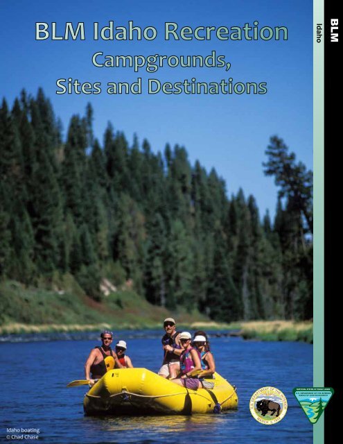
<strong>BLM</strong> <strong>Idaho</strong> <strong>Recreation</strong><br />
<strong>Idaho</strong><br />
Campgrounds,<br />
Sites and Destinations<br />
<strong>Idaho</strong> boating<br />
© Chad Chase<br />
1
Inside Cover is blank
<strong>BLM</strong> <strong>Idaho</strong> <strong>Recreation</strong><br />
Campgrounds,<br />
Sites and Destinations<br />
U.S. Department <strong>of</strong> the Interior<br />
<strong>Bureau</strong> <strong>of</strong> <strong>Land</strong> <strong>Management</strong><br />
<strong>Idaho</strong> State Office<br />
1387 S. Vinnell Way<br />
Boise, ID 83709<br />
(208) 373-4000<br />
http://www.blm.gov/id<br />
www.facebook.com/blmidaho<br />
www.youtube.com/blmidaho
This page is blank
Welcome to Your Public <strong>Land</strong>s 6<br />
“Know Before You Go” 7<br />
Contact Us 8<br />
Map Legend 9<br />
Southwestern <strong>Idaho</strong><br />
Bruneau Field Office 10-13<br />
Four Rivers Field Office 14-17<br />
Morley Nelson Snake River Birds <strong>of</strong> Prey 18-21<br />
Owyhee Field Office 22-25<br />
Northern <strong>Idaho</strong><br />
Coeur d’ Alene Field Office 26-29<br />
Cottonwood Field Office 30-33<br />
Eastern <strong>Idaho</strong><br />
Challis Field Office 34-37<br />
Pocatello Field Office 38-41<br />
Salmon Field Office 42-45<br />
Upper Snake Field Office 46-49<br />
Central <strong>Idaho</strong><br />
Burley Field Office 50-53<br />
Jarbidge Field Office 54-57<br />
Shoshone Field Office 58-61<br />
Table <strong>of</strong> Contents<br />
Owyhee River Canyon<br />
Hulls Gulch National <strong>Recreation</strong> Trail<br />
© Glenn Oakley
Welcome to Your Public <strong>Land</strong>s<br />
Recreating on public lands in <strong>Idaho</strong> can mean<br />
relaxing while fly-fishing along a scenic<br />
shoreline, backpacking through awe-inspiring<br />
mountains, paddling through world-class<br />
whitewater in remote canyons or riding<br />
<strong>of</strong>f-highway vehicles (OHVs) through vast<br />
mountain and desert landscapes.<br />
Outdoor recreation opportunities abound<br />
throughout the diverse landscapes <strong>of</strong> <strong>Idaho</strong>’s<br />
12 million acres <strong>of</strong> public land managed by the<br />
<strong>Bureau</strong> <strong>of</strong> <strong>Land</strong> <strong>Management</strong> (<strong>BLM</strong>).<br />
These public lands host many unique and<br />
special outdoor opportunities where visitors<br />
can enjoy some <strong>of</strong> the most scenic spots in<br />
<strong>Idaho</strong> and learn more about the state’s<br />
history. Many <strong>of</strong> these sites are part <strong>of</strong> the<br />
<strong>BLM</strong>’s National <strong>Land</strong>scape Conservation<br />
System (NLCS), which serves to protect and<br />
conserve special places on public lands.<br />
Check out the spectacular wilderness areas and<br />
wild and scenic rivers <strong>of</strong> the Owyhee<br />
Canyonlands, walk the vast lava fields <strong>of</strong> the<br />
Craters <strong>of</strong> the Moon National Monument,<br />
or view raptors at the Morley Nelson Snake<br />
River Birds <strong>of</strong> Prey National Conservation Area.<br />
Take a step back in time to learn more about<br />
<strong>Idaho</strong>’s history by exploring the National<br />
Scenic and Historic Trails <strong>of</strong> <strong>Idaho</strong> including the<br />
Lewis and Clark, Nez Perce, Oregon, California<br />
and Continental Divide Trails.<br />
Explore <strong>Idaho</strong> by taking one <strong>of</strong> the many Scenic<br />
or Backcountry Byways that traverse the state.<br />
Find a quiet spot to stop along the route, grab<br />
binoculars and search for the variety <strong>of</strong> wildlife<br />
that call this area home.<br />
Get outside to hike with the family on the<br />
Mineral Ridge or Hulls Gulch National<br />
<strong>Recreation</strong> Trails (both have interpretive<br />
signage) or camp next to the mighty Salmon<br />
River at one <strong>of</strong> <strong>BLM</strong>’s many developed<br />
recreation sites.<br />
A diversity <strong>of</strong> recreational opportunities is<br />
available in <strong>Idaho</strong> for individuals <strong>of</strong> all ages and<br />
interests. Public lands may be located in your<br />
backyard, so get out and explore the outdoors,<br />
it’s yours!<br />
6<br />
Big Southern Butte<br />
© James Neeley
Know Before You Go....<br />
Dispersed Camping<br />
Many people enjoy the solitude <strong>of</strong> camping<br />
away from developed campgrounds. Follow<br />
these guidelines to ensure that these areas can<br />
be enjoyed by future generations:<br />
• Choose sites that are already established.<br />
• Camp at least 100 feet away from water<br />
sources.<br />
• Use existing fire rings or camp stoves.<br />
• Check current fire conditions.<br />
• Dispose <strong>of</strong> human waste properly (away<br />
from water and in a 6” or deeper hole).<br />
Hunting<br />
Most public land is open to hunting and<br />
shooting. Help keep it open by reporting trash<br />
and vandalism. For more information, contact<br />
the <strong>Idaho</strong> Department <strong>of</strong> Fish and Game at<br />
208-334-3700 or visit the website:<br />
http://fishandgame.idaho.gov.<br />
Boating<br />
Zebra and quagga mussels attach to boats, bait<br />
buckets and other gear, then spread in waters<br />
where they can destroy fish habitat and clog<br />
public water pipes. Help stop the spread <strong>of</strong><br />
invasive aquatic species by following these<br />
steps:<br />
Travel responsibly on land by staying on<br />
designated roads, trails and areas.<br />
Respect the rights <strong>of</strong> others, including private<br />
property owners and fellow recreationists.<br />
Educate and prepare yourself prior to your trip<br />
by obtaining proper equipment, compasses and<br />
travel maps. Learn about local regulations from<br />
public agencies. Alert friends and family about<br />
travel intentions. Always be prepared for<br />
changing weather conditions.<br />
Avoid sensitive areas on land such as meadows,<br />
lakeshores, wetlands and streams.<br />
Do your part by modeling appropriate<br />
behavior by leaving the area better than you<br />
found it. Pack It In, Pack It Out, clean up after<br />
yourself and do not leave trash behind.<br />
• Boaters are required to purchase an <strong>Idaho</strong><br />
Invasive Species Fund (IISF) sticker prior to<br />
launching their vessel.<br />
• Drain the ballast tanks, bilge, livewells and<br />
motor. Dry (7 days summer; 18 days spring/<br />
fall; and 30 days winter) or freeze (3 days).<br />
Noxious Weeds<br />
Noxious weeds can rapidly displace native plant<br />
species that provide food for wildlife and<br />
livestock. Here’s how you can prevent the<br />
spread <strong>of</strong> noxious weeds:<br />
• Wash your vehicle, including the<br />
undercarriage to remove any weed seed<br />
before driving to public lands.<br />
• Use weed-free hay when riding on or<br />
packing in with horses.<br />
7<br />
Clearwater River<br />
© Chad Chase
Contact Us<br />
Four <strong>BLM</strong> district <strong>of</strong>fices, 12 field <strong>of</strong>fices, and the <strong>Idaho</strong> State Office administer the public lands in <strong>Idaho</strong>. For<br />
more information, please reference the colors below throughout the booklet and on the associated maps.<br />
<strong>BLM</strong> <strong>Idaho</strong> State Office<br />
1387 S. Vinnell Way<br />
Boise, <strong>Idaho</strong> 83709<br />
Public Desk: 208-373-4000<br />
E-mail: <strong>BLM</strong>_ID_StateOffice@blm.gov<br />
Southwestern <strong>Idaho</strong><br />
Bruneau Field Office<br />
3948 Development Avenue<br />
Boise, ID 83705<br />
Phone: 208-384-3300<br />
Four Rivers Field Office/<br />
Snake River Birds <strong>of</strong> Prey National<br />
Conservation Area<br />
3948 Development Avenue<br />
Boise, ID 83705<br />
Phone: 208-384-3300<br />
Owyhee Field Office<br />
20 First Avenue West<br />
Marsing, ID 83639<br />
Phone: 208-896-5912<br />
Northern <strong>Idaho</strong><br />
Coeur d’Alene Field Office<br />
3815 Schreiber Way<br />
Coeur d’Alene, ID 83815<br />
Phone: 208-769-5000<br />
Cottonwood Field Office<br />
1 Butte Drive<br />
Cottonwood, ID 83522<br />
Phone: 208-962-3245<br />
Salmon Field Office<br />
1206 South Challis Street<br />
Salmon, ID 83467<br />
Phone: 208-756-5400<br />
Upper Snake Field Office<br />
1405 Hollipark Drive<br />
<strong>Idaho</strong> Falls, ID 83401<br />
Phone: 208-524-7500<br />
Central <strong>Idaho</strong><br />
Northern<br />
Burley Field Office<br />
15 East 200 South<br />
Burley, ID 83318<br />
Phone: 208-677-6600<br />
Jarbidge Field Office<br />
2536 Kimberly Road<br />
Twin Falls, ID 83301<br />
Phone: 208-735-2060<br />
Shoshone Field Office/<br />
Craters <strong>of</strong> the Moon National Monument<br />
400 West “F” Street<br />
Shoshone, ID 83352<br />
Phone: 208-732-7200<br />
Eastern <strong>Idaho</strong><br />
Challis Field Office<br />
1151 Blue Mountain Road<br />
Challis, ID 83226<br />
Phone: 208-879-6200<br />
Pocatello Field Office<br />
4350 Cliffs Drive<br />
Pocatello, ID 83204<br />
Phone: 208-478-6340<br />
Southwestern<br />
Eastern<br />
8<br />
Central
Map Legend<br />
Please reference the following legend for maps throughout the booklet.<br />
<strong>Recreation</strong> Site and General<br />
<strong>BLM</strong> <strong>Management</strong> Area<br />
Southwestern <strong>Idaho</strong><br />
# Bruneau Field Office<br />
# Four Rivers Field Office<br />
# Morley Nelson Snake River<br />
Birds <strong>of</strong> Prey NCA<br />
# Owyhee Field Office<br />
Northern <strong>Idaho</strong><br />
#<br />
#<br />
Coeur d’ Alene Field Office<br />
Cottonwood Field Office<br />
Eastern <strong>Idaho</strong><br />
#<br />
#<br />
#<br />
#<br />
Central <strong>Idaho</strong><br />
# Burley Field Office<br />
# Jarbidge Field Office<br />
#<br />
Challis Field Office<br />
Pocatello Field Office<br />
Salmon Field Office<br />
Upper Snake Field Office<br />
Shoshone Field Office/<br />
Craters <strong>of</strong> the Moon NCA<br />
<strong>Land</strong> Status<br />
Managing Agency<br />
<strong>Bureau</strong> <strong>of</strong> <strong>Land</strong> <strong>Management</strong><br />
Private<br />
US Forest Service<br />
State <strong>of</strong> <strong>Idaho</strong><br />
State <strong>of</strong> <strong>Idaho</strong> Fish & Game;<br />
State <strong>of</strong> <strong>Idaho</strong> Parks & Rec<br />
<strong>Bureau</strong> <strong>of</strong> Reclamation<br />
Corps <strong>of</strong> Engineers<br />
Military Reservations and<br />
Corps <strong>of</strong> Engineers<br />
Indian Reservation<br />
Military <strong>Land</strong><br />
National Park Service<br />
National Wildlife Refuge<br />
Bankhead-Jones LU <strong>Land</strong>s<br />
(Admin by Acquiring Agency)<br />
National Grasslands<br />
(Admin by USFS)<br />
£ §¨¦ 15<br />
¬« 21<br />
£¤ 93<br />
Map Symbols<br />
Designated Wilderness Area<br />
National Wild and Scenic River<br />
Special <strong>Management</strong> Area<br />
County Boundary<br />
Interstate Highway<br />
US Highway<br />
State Highway<br />
Note: Roads partly revised 2011<br />
“No warranty is made by the <strong>Bureau</strong> <strong>of</strong> <strong>Land</strong> <strong>Management</strong> (<strong>BLM</strong>).<br />
The accuracy, reliability, or completeness <strong>of</strong> these data for<br />
individual use or aggregate use with other data is not guaranteed.<br />
Map scale varies in illustrations.”<br />
Created by <strong>BLM</strong>, <strong>Idaho</strong> State Office, 2012.<br />
Boating the Payette River<br />
9<br />
Local student illustration depicting “favorite activity on<br />
public lands.” Don’t miss more student illustrations on<br />
the back <strong>of</strong> the statewide map.
Southwestern <strong>Idaho</strong>: Bruneau Field Office<br />
Some <strong>of</strong> the most spectacular and untouched<br />
high desert landscapes in the United States can<br />
be found here. From the sweeping plateaus<br />
and towering canyons <strong>of</strong> the Owyhee<br />
Canyonlands and the solitude <strong>of</strong> the Big and<br />
Little Jacks Creek Wilderness Areas, to the<br />
excellent wildlife viewing along the Owyhee<br />
Uplands Backcountry Byway, memorable vistas<br />
and experiences are around each turn.<br />
Three wilderness areas including the Big Jacks<br />
Creek Wilderness, Little Jacks Creek Wilderness,<br />
and the Bruneau-Jarbidge River Wilderness are<br />
located in this region. The waterways through<br />
much <strong>of</strong> these wilderness areas are also<br />
designated as Wild & Scenic Rivers.<br />
The spectacular Owyhee, Deep Creek, Bruneau<br />
and Jarbidge Rivers are floatable in the spring,<br />
but are only recommended for experienced and<br />
well-prepared boaters. These remote<br />
rivers have difficult put-in and take-out locations<br />
(especially in bad weather) and have<br />
challenging Class II - V whitewater with difficult<br />
portages. A waterpro<strong>of</strong> river guide is available<br />
from the <strong>BLM</strong>.<br />
coverage is unlikely. To ensure a safe trip and<br />
return, be prepared with proper equipment,<br />
maps, compasses, clothing and knowledge <strong>of</strong><br />
the general area and weather conditions.<br />
Wilderness areas and wild and scenic rivers are<br />
part <strong>of</strong> the <strong>BLM</strong>’s National <strong>Land</strong>scape<br />
Conservation System, which serves to protect<br />
and conserve special places on public lands.<br />
Help care for and protect this fragile<br />
environment for current and future generations<br />
by leaving no trace and packing out what you<br />
pack in. Decrease the chance <strong>of</strong><br />
contaminating the water supply and minimize<br />
wildlife disturbance by camping at least 200<br />
feet from streams.<br />
Visitors to this area can also enjoy bird<br />
watching, camping, big game and upland bird<br />
hunting, hiking, motorized recreation,<br />
horseback riding and driving for pleasure.<br />
The only developed recreation spot in this<br />
region is Poison Creek picnic site. This site has<br />
tables, grills, fire grates, one vault toilet,<br />
shaded areas and a small trail.<br />
The Owyhee Uplands Back Country Byway, also<br />
called Mud Flat Road, is a scenic driving route<br />
across the Owyhee Plateau and Canyonlands.<br />
Traversing 92 miles in <strong>Idaho</strong> and 12 in Oregon,<br />
the Byway allows visitors to explore different<br />
vegetative zones, including juniper and<br />
mahogany stands and sagebrush and<br />
aspen-covered plateaus.<br />
Take proper precautions when visiting this<br />
harsh, remote environment. Cell phone<br />
10<br />
Bruneau River Canyon
Exploring the area on bikes<br />
© Chad Chase<br />
11<br />
Battle Creek Wild and Scenic River
Bruneau Field<br />
Office<br />
Poison Creek<br />
Picnic Site<br />
<strong>Recreation</strong> Site No.<br />
Elevation (feet)<br />
Day Use Only<br />
Fees<br />
No. Camp Sites*<br />
#<br />
E<br />
1 4478 4<br />
No. Group Sites<br />
G<br />
Day-Use Shelters<br />
Accessibility<br />
Drinking Water<br />
Toilets<br />
RV Dump Station<br />
RV Hookups<br />
Boat Access<br />
Boat Ramp<br />
Fishing<br />
OHV Trailheads<br />
Hiking<br />
Biking<br />
Interpretation<br />
RV = <strong>Recreation</strong>al vehicle<br />
OHV = Off-highway vehicle<br />
*Designated campsites have fire grill and table<br />
East Fork <strong>of</strong> the Owyhee River<br />
© Mark Lisk<br />
12
Birch Creek<br />
To<br />
Murphy<br />
Sho<strong>of</strong>ly Rd<br />
Sho<strong>of</strong>ly<br />
Creek<br />
Snake<br />
ELMORE<br />
River<br />
¬«78<br />
C J Strike<br />
Morley Nelson<br />
Snake River<br />
Birds <strong>of</strong> Prey NCA<br />
Reservoir<br />
Crane<br />
Falls Lake<br />
Poison<br />
Creek<br />
To<br />
Bruneau<br />
C ut<br />
Sho<strong>of</strong>ly Cut Off Rd<br />
Off Rd<br />
Poison<br />
Creek<br />
Creek<br />
Poison Creek<br />
Rd<br />
Sho<strong>of</strong>ly Rd<br />
Jack s<br />
Creek<br />
Sugar Valley Rd<br />
Snow Creek<br />
West<br />
1<br />
East<br />
Mud<br />
Flat Rd<br />
Fo rk<br />
Fork<br />
Sho<strong>of</strong>ly<br />
Little Jacks Creek<br />
Wilderness<br />
OWYHEE<br />
Little<br />
Ja<br />
cks Creek<br />
Creek<br />
Jacks<br />
Big<br />
O X Prong<br />
Creek<br />
¬«51<br />
ittle<br />
L<br />
Jacks<br />
Creek<br />
Rattlesna ke<br />
Creek<br />
Big Jacks Creek<br />
Wilderness<br />
Sugar Creek<br />
Big<br />
Jacks<br />
Willies Creek<br />
Creek<br />
Cotton w ood<br />
Jacks<br />
Creek<br />
Reservoir<br />
Creek<br />
Duncan<br />
Creek<br />
Creek<br />
y<br />
Wickaho ne<br />
2 1 0 2 4 Miles<br />
To<br />
Riddle<br />
±<br />
Blackstone<br />
Reservoir<br />
13
Southwestern <strong>Idaho</strong>: Four Rivers Field Office<br />
This region is the backyard <strong>of</strong> <strong>Idaho</strong>’s largest<br />
city (Boise), yet <strong>of</strong>fers easy access to unspoiled<br />
destinations for outdoor adventure.<br />
The 130-mile Ridge to Rivers Trail System<br />
<strong>of</strong>fers hikers, bikers and wildlife viewers plenty<br />
<strong>of</strong> trails to explore. Seven miles up Eighth Street<br />
from Boise’s North End, the three-mile Hulls<br />
Gulch National <strong>Recreation</strong> Trail <strong>of</strong>fers a quiet<br />
escape from the city and interpretive signs<br />
teach visitors about the unique natural history<br />
<strong>of</strong> the Boise Foothills.<br />
In the mid-1800s, thousands <strong>of</strong> pioneers<br />
followed the Oregon Trail 2,000 miles from<br />
Missouri to Oregon in search <strong>of</strong> a better life.<br />
Located southeast <strong>of</strong> Boise, the 135-mile stretch<br />
<strong>of</strong> the Oregon National Historic Trail, can be<br />
experienced from a car or explored on foot.<br />
Original wagon wheel ruts are visible today on<br />
the North Trail and Sinker Creek segments.<br />
At Bonneville Point, visitors can stand in the<br />
same spot where Captain Benjamin Bonneville<br />
and his expedition party overlooked the valley<br />
he named Les Bois, site <strong>of</strong> the city that today<br />
bears the same name — Boise. The site is also<br />
an access point for the Oregon Trail and a place<br />
to hike, picnic, geocache and view wildlife.<br />
The Payette River <strong>of</strong>fers opportunities for<br />
recreationists <strong>of</strong> all skill levels to kayak, canoe<br />
and fish. Motorized and non-motorized boating<br />
are allowed and rafting enthusiasts can expect<br />
rapids <strong>of</strong> varying difficulties. Local outfitters<br />
<strong>of</strong>fer half and full day trips <strong>of</strong> this scenic river.<br />
Brownlee Reservoir is a popular fishing location<br />
known for its great catfish, crappie and small<br />
mouth bass. Fishermen can set-up camp and<br />
launch their fishing boats at Steck Park<br />
campground. Steck Park, located at the<br />
southern end <strong>of</strong> the 56-mile-long reservoir,<br />
<strong>of</strong>fers access to Brownlee Reservoir along the<br />
Snake River from the <strong>Idaho</strong> side <strong>of</strong> Hell’s<br />
Canyon.<br />
14<br />
Biking the Ridge to Rivers trail system
Boise Whitewater Festival<br />
Little Gem motorcycle park<br />
15<br />
Hulls Gulch National <strong>Recreation</strong> Trail
Four Rivers<br />
Field Office<br />
<strong>Recreation</strong> Site No.<br />
#<br />
Elevation (feet)<br />
E<br />
Day Use Only<br />
Fees<br />
No. Camp Sites*<br />
No. Group Sites<br />
G<br />
Day-Use Shelters<br />
Accessibility<br />
Drinking Water<br />
Toilets<br />
RV Dump Station<br />
RV Hookups<br />
Boat Access<br />
Boat Ramp<br />
Fishing<br />
OHV Trailheads<br />
Hiking<br />
Biking<br />
Interpretation<br />
Bonneville Point 2 3865<br />
Clay Peak 3 2214<br />
Payette River System Ridge to Rivers Trails<br />
8th Street<br />
Trail<br />
Lower Hulls<br />
Gulch<br />
Upper Hulls<br />
Gulch<br />
4 3800<br />
5 3900<br />
6 4747<br />
Miller Gulch 7 3326<br />
Little Gem 8 2900<br />
North Fork 9 4832<br />
Banks Access 10 2820<br />
Beehive Bend 11 2726<br />
Chief Parrish 12 2755<br />
Confluence 13 2801<br />
Deer Creek 14 2979<br />
South Fork 15 3116 P P<br />
Steck Park 16 2112 21 W<br />
Weiser Dunes 17 2132<br />
RV = <strong>Recreation</strong>al vehicle<br />
OHV = Off-highway vehicle<br />
P = Primitive Camping - No designated sites; Fire ring may be available<br />
*Designated campsites have fire grill and table<br />
W=Water<br />
Boat Access= Non-motorized; Boat Ramp= Concrete ramp for motorized access<br />
16
16<br />
17<br />
!<br />
O R E G O N<br />
Brownlee<br />
Reservoir<br />
Olds<br />
Ferry<br />
Olds Ferry Rd<br />
Snake<br />
O R E G O N<br />
!<br />
!<br />
!<br />
!<br />
!<br />
!<br />
!<br />
!<br />
!<br />
!<br />
!<br />
!<br />
!<br />
!<br />
Cambridge<br />
!<br />
!<br />
!<br />
!<br />
Council<br />
Mesa<br />
!<br />
! !<br />
Kuna<br />
!<br />
!<br />
!<br />
To<br />
New Meadows<br />
Cascade<br />
£¤ 95<br />
Ben<br />
Ross<br />
Reservoir<br />
Midvale<br />
WASHINGTON<br />
Mann<br />
Creek<br />
Reservoir<br />
Crane<br />
Creek<br />
Reservoir<br />
Smiths Ferry<br />
Weiser<br />
Paddock<br />
Valley<br />
Reservoir<br />
Crystal<br />
Payette<br />
Banks<br />
3<br />
10<br />
¬«52 PAYETTE<br />
Fruitland<br />
New Plymouth<br />
GEM<br />
Gardena<br />
¬«72<br />
£¤ 95 Black<br />
¬«52<br />
Horseshoe<br />
Canyon<br />
Bend<br />
Reservoir<br />
Emmett<br />
§¨¦ 84 BOISE<br />
¬«52<br />
8 ¬«55<br />
Parma<br />
¬«16<br />
Notus<br />
Middleton<br />
Star Eagle<br />
Wilder<br />
¬« 44<br />
Greenleaf<br />
Caldwell<br />
¬« 19 CANYON £¤ 20<br />
7 6<br />
¬« 19 Homedale<br />
Meridian<br />
¬«55 4 5<br />
Boise<br />
£¤ 95 ¬«55<br />
§¨¦ 184 Lake<br />
Lowell<br />
Nampa ADA<br />
Marsing<br />
¬«<br />
¬« 45<br />
69<br />
§¨¦ 84<br />
River<br />
To<br />
Ontario, Ore<br />
OWYHEE<br />
Jump<br />
Sna ke<br />
Creek<br />
River<br />
Weiser<br />
¬«78<br />
¬«71<br />
To<br />
Jordan<br />
Valley, Ore<br />
Riv er<br />
Payette<br />
Ri ver<br />
Weiser<br />
River<br />
5 0 5 10<br />
Miles<br />
Mid d<br />
Little<br />
le<br />
Weiser<br />
ADAMS<br />
!<br />
Fork<br />
River<br />
Weiser<br />
Boise<br />
iver<br />
R<br />
!<br />
!<br />
!<br />
River<br />
To<br />
Mountain<br />
Home<br />
9<br />
!<br />
Bank<br />
!<br />
Reservoir<br />
s<br />
Donnelly<br />
¬«55<br />
!<br />
VALLEY<br />
Cascade<br />
Crouch<br />
!<br />
Lowman<br />
! !<br />
¬«21<br />
Fo rk<br />
Nort h<br />
Payette<br />
River<br />
13<br />
14<br />
Garden<br />
Valley<br />
11 12 15<br />
Lu cky<br />
2<br />
Peak Lake<br />
±<br />
Hwy<br />
ELMORE<br />
17
Southwestern <strong>Idaho</strong>: Morley Nelson Snake River Birds <strong>of</strong> Prey<br />
National Conservation Area<br />
This area’s spectacular, vast and unique<br />
landscape supports one <strong>of</strong> the world’s<br />
densest concentrations <strong>of</strong> nesting birds <strong>of</strong> prey.<br />
Congress established the Morley Nelson Snake<br />
River Birds <strong>of</strong> Prey National Conservation Area<br />
(NCA) in 1993 to help recognize and protect the<br />
area’s wildlife values. This 485,000-acre area<br />
hosts about 800 pairs <strong>of</strong> falcons, eagles, hawks<br />
and owls that arrive each spring to mate and<br />
raise their young.<br />
In addition to outstanding bird and wildlife<br />
viewing, this area hosts various recreational<br />
opportunities. Visitors can sightsee, ride on<br />
horseback, hike, hunt, mountain bike, picnic and<br />
camp. The NCA is one <strong>of</strong> the many units within<br />
the <strong>BLM</strong>’s National <strong>Land</strong>scape Conservation<br />
System which serves to protect and conserve<br />
special places on public lands.<br />
Catch a glimpse <strong>of</strong> the area’s birds <strong>of</strong> prey at<br />
Dedication Point, a spectacular overlook on the<br />
rim <strong>of</strong> the Snake River Canyon. A ¼-mile trail<br />
with interpretive signs <strong>of</strong>fers insights about the<br />
birds, geology and other wildlife.<br />
Site. This is a popular area to fish, hike, view<br />
wildlife, boat (motorized and non-motorized),<br />
waterski, swim and picnic. About one mile east<br />
<strong>of</strong> the dam, day-use and overnight camping<br />
facilities are available on the south shore <strong>of</strong> C.J.<br />
Strike Reservoir.<br />
Halverson Lake is nestled along the canyon<br />
wall with opportunities for all types <strong>of</strong> outdoor<br />
adventure, as well as cultural education. During<br />
a visit to Halverson Lake, visitors can also check<br />
out Celebration Park to learn about the history<br />
<strong>of</strong> Native Americans who still use this area.<br />
Spring and fall weather conditions in sheltered<br />
canyon areas average 5-10 °F warmer than<br />
temperatures in nearby Boise. This makes<br />
recreation outdoors possible in the late winter,<br />
spring and fall when many higher-elevation<br />
recreation areas are still affected by weather.<br />
A visitor guide containing general maps <strong>of</strong> the<br />
NCA, raptor viewing information, shooting<br />
regulations/information and recreational<br />
opportunities is available from the <strong>BLM</strong>.<br />
Experience the magnificence <strong>of</strong> this area from<br />
the waters and shorelines <strong>of</strong> Cove <strong>Recreation</strong><br />
18<br />
Morley Nelson Snake River Birds <strong>of</strong> Prey Area<br />
© Glenn Oakley
Morley Nelson Snake River Birds <strong>of</strong> Prey Area<br />
© Glenn Oakley<br />
19<br />
Ferruginous Hawks
Morley Nelson<br />
Snake River<br />
Birds <strong>of</strong> Prey<br />
National<br />
Conservation<br />
Area<br />
<strong>Recreation</strong> Site No.<br />
#<br />
Elevation (feet)<br />
E<br />
Day Use Only<br />
Fees<br />
No. Camp Sites*<br />
No. Group Sites<br />
G<br />
Day-Use Shelters<br />
Accessibility<br />
Drinking Water<br />
Toilets<br />
RV Dump Station<br />
RV Hookups<br />
Boat Access<br />
Boat Ramp<br />
Fishing<br />
OHV Trailheads<br />
Hiking<br />
Biking<br />
Interpretation<br />
Celebration Park 18 2362 P<br />
Cove at CJ Strike<br />
Reservoir<br />
19 2500 26 1<br />
Dedication Point 20 2877<br />
Halverson Bar/<br />
Lake<br />
21 2329<br />
Swan Falls Area 22 2309 P<br />
RV = <strong>Recreation</strong>al vehicle<br />
OHV = Off-highway vehicle<br />
P = Primitive Camping - No designated sites; Fire ring may be available<br />
*Designated campsites have fire grill and table<br />
Boat Access= Non-motorized; Boat Ramp= Concrete ramp for motorized access<br />
20<br />
Morley Nelson Snake River Birds <strong>of</strong> Prey Area<br />
© Glenn Oakley
Boi<br />
To<br />
Caldwell<br />
¬«55<br />
Nampa<br />
Lake<br />
Lowell<br />
Rabbit<br />
Briar<br />
CANYON<br />
¬«45<br />
Creek<br />
Murphy<br />
Creek<br />
!<br />
!<br />
Melba<br />
Victory<br />
!<br />
¬«78<br />
Pickett<br />
Ln<br />
OWYHEE<br />
£¤ 20 ¬«44<br />
¬«55<br />
BOISE<br />
Garden City<br />
¬«21<br />
Meridian<br />
Boise<br />
§¨¦184<br />
Lucky<br />
¬«69<br />
Peak<br />
Lake<br />
Blacks<br />
Creek<br />
ADA<br />
Res<br />
Initial<br />
Point<br />
Morley Nelson<br />
ELMORE<br />
Swan 22 Snake River<br />
Falls<br />
Dam Birds <strong>of</strong> Prey NCA<br />
£¤ 20<br />
§¨¦84<br />
Kuna<br />
Swan Falls Rd<br />
!<br />
21 18<br />
20<br />
Fossil<br />
Sinker<br />
Creek<br />
Mud<br />
!<br />
Cree k<br />
Cr<br />
Castle<br />
Sna ke River<br />
eek<br />
Creek<br />
Flat<br />
Tenmile Creek<br />
Birch<br />
Rd<br />
Po<br />
Creek<br />
Boise<br />
!<br />
!<br />
Grand View<br />
Poison Creek Rd<br />
Sho<strong>of</strong>ly<br />
ison Creek<br />
River<br />
Corder<br />
Creek<br />
Sh o<strong>of</strong>ly<br />
Little Jacks Creek<br />
Rd<br />
!<br />
Little<br />
Creek<br />
Blacks<br />
¬«67<br />
Sho<strong>of</strong>ly Cut Off Rd<br />
Jacks Creek<br />
Creek<br />
C<br />
19<br />
Jacks<br />
Canyon<br />
¬<br />
A<br />
¬«78<br />
r row<br />
Cree k<br />
C reek<br />
Creek<br />
J St rike Reservoir<br />
rock<br />
¬«51<br />
Bruneau<br />
Hot Creek Rd<br />
Rese r voir<br />
!<br />
C CC<br />
Rd<br />
Hot Springs Rd<br />
Bruneau<br />
South<br />
Mountain<br />
Home<br />
¬«51<br />
River<br />
!<br />
Fork<br />
s<br />
e<br />
Mountain<br />
Home<br />
Res<br />
Snake<br />
¬«78<br />
Overlook<br />
Rd<br />
Weast<br />
Fork<br />
Ri ver<br />
Rive r<br />
Creek<br />
Browns<br />
§¨¦84<br />
Browns<br />
Hammett<br />
Creek<br />
Saylor Creek<br />
Air Force Range<br />
To<br />
Fairfield<br />
!<br />
Pot Hole<br />
Anderson<br />
Ranch<br />
Res<br />
Creek<br />
Bennett<br />
To<br />
Glenns<br />
Ferry<br />
Cr ek<br />
Pole Creek<br />
Wilderness<br />
4 0 4 8<br />
Miles<br />
Wilderness<br />
Creek<br />
Big Jacks Creek<br />
Wilderness<br />
Jacks<br />
g<br />
Bi<br />
¬«51<br />
Missle Base Rd<br />
r<br />
Suga<br />
Hot<br />
Broken Wagon<br />
Flat Rd<br />
Creek<br />
Bruneau-Jarbidge<br />
Rivers Wilderness<br />
Clover Three<br />
Creek Rd<br />
!<br />
Clov<br />
Winter<br />
Camp<br />
er<br />
±<br />
Cr<br />
eek<br />
21
Southwestern <strong>Idaho</strong>: Owyhee Field Office<br />
From the sheer rock cliffs and magnificent<br />
plateaus <strong>of</strong> the Owyhee Canyonlands, to the<br />
scenery and wildlife viewing available along<br />
the Owyhee Uplands Backcountry Byway, the<br />
southwest corner <strong>of</strong> <strong>Idaho</strong> is a special place to<br />
visit. Visitors will find plenty <strong>of</strong> opportunities to<br />
explore, find solitude, and experience some <strong>of</strong><br />
nature’s most wild places in this remote,<br />
rugged country. The area includes two<br />
wilderness areas and multiple sections <strong>of</strong> wild<br />
and scenic rivers.<br />
The Owyhee Uplands Backcountry Byway<br />
represents high desert scenery at its finest.<br />
Along the route, visitors are treated to views <strong>of</strong><br />
the surrounding sagebrush-steppe ecosystem<br />
that provides habitat for over 180 species <strong>of</strong><br />
birds and mammals. Scenic geologic<br />
formations, composed <strong>of</strong> volcanic rock<br />
deposited 8-12 million years ago, are also<br />
present in this area.<br />
For <strong>of</strong>f-highway vehicle (OHV) enthusiasts, this<br />
area features three popular trailheads along the<br />
Owyhee Front. Trails include single tracks for<br />
motorcycles and wider trails and<br />
two-tracks for all terrain vehicles (ATVs) and<br />
other motorized vehicles.<br />
Plenty <strong>of</strong> non-motorized adventures are also<br />
available. Hikers who travel ¼ mile to Jump<br />
Creek Falls will discover a lush riparian<br />
community filled with waterbirch and red osier<br />
dogwood trees.<br />
History comes alive at the Silver City<br />
campground, located in a partially restored 19th<br />
century mining town in the Owyhee Mountains.<br />
The Owyhee River System, sometimes called<br />
the “Grand Canyon <strong>of</strong> the Owyhee,” is famous<br />
for its deep canyons, steep cliffs, turbulent<br />
whitewater, brilliant wildflowers and abundant<br />
wildlife. Golden eagles, falcons, hawks, bighorn<br />
sheep and deer all call this area home. Much <strong>of</strong><br />
the Owyhee River and its tributaries are<br />
designated as wild and scenic rivers and nearly<br />
70 miles <strong>of</strong> the river, upstream from the<br />
<strong>Idaho</strong>-Oregon border, is within the Owyhee<br />
River Wilderness area.<br />
These designations protect the unique<br />
character <strong>of</strong> this area and make it part <strong>of</strong> the<br />
<strong>BLM</strong>’s National <strong>Land</strong>scape Conservation<br />
System, which serves to protect and conserve<br />
special places on public lands.<br />
Rafting and kayaking the Owyhee with its Class<br />
II - V whitewater is popular in the spring during<br />
higher water flows. Low water float trips are<br />
also possible in smaller craft.<br />
22<br />
Owyhee River Canyon<br />
© Glenn Oakley
Owyhee Wilderness<br />
© Glenn Oakley<br />
23<br />
Owyhee River<br />
© Glenn Oakley
Owyhee Field<br />
Office<br />
Hemingway<br />
Butte<br />
<strong>Recreation</strong> Site No.<br />
Elevation (feet)<br />
#<br />
E<br />
23 2480<br />
Day Use Only<br />
Fees<br />
No. Camp Sites *<br />
No. Group Sites<br />
G<br />
Day-Use Shelters<br />
Accessibility<br />
Drinking Water<br />
Toilets<br />
RV Dump Station<br />
RV Hookups<br />
Boat Access<br />
Boat Ramp<br />
Fishing<br />
OHV Trailheads<br />
Hiking<br />
Biking<br />
Interpretation<br />
Jump Creek 24 2650<br />
North Fork 25 4763 7<br />
Rabbit Creek 26 2772<br />
Silver City 27 6161 6<br />
Wilson Creek 28 2762<br />
RV = <strong>Recreation</strong>al vehicle<br />
OHV = Off-highway vehicle<br />
*Designated campsites have fire grill and table<br />
Boat Access= Non-motorized; Boat Ramp= Concrete ramp for motorized access<br />
Owyhee Uplands Backcountry Byway<br />
24
Basin Rd<br />
S ands<br />
Jump Creek<br />
24<br />
To<br />
Marsing To<br />
Nampa<br />
Som mer<br />
Camp<br />
Rd<br />
Givens Hot Springs<br />
!<br />
CANYON<br />
¬«78<br />
Sna ke<br />
¬«45<br />
Kuna<br />
!<br />
£¤95<br />
Wilson<br />
")<br />
28<br />
Creek Rd<br />
")<br />
23<br />
River<br />
Victory<br />
Jensen<br />
Lake<br />
Ln<br />
Swan Falls Rd<br />
Initial<br />
Point<br />
Morley Nelson<br />
O R E G O N<br />
To<br />
Jordan<br />
Valley, Ore<br />
Reynolds<br />
Upper Reyno<br />
!<br />
lds Cre ek R<br />
Reynold<br />
d<br />
s Cr<br />
Murphy<br />
eek Stage Rd<br />
26<br />
")<br />
!<br />
Swan<br />
Falls<br />
Dam<br />
!<br />
Snake<br />
Snake River<br />
Birds <strong>of</strong> Prey NCA<br />
Swan Falls<br />
ADA<br />
River<br />
Silver City<br />
!<br />
27<br />
r<br />
Silve<br />
City<br />
Rd<br />
¬«78<br />
Oreana<br />
!<br />
Oreana Rd<br />
Henderson Rd<br />
Foremans<br />
Reservoir<br />
Castle Creek Rd<br />
ELMORE<br />
To<br />
Murphy<br />
OWYHEE<br />
Triangle Rd<br />
Poison<br />
O R E G O N<br />
Flint<br />
Rd<br />
±<br />
Creek Cut<strong>of</strong>f<br />
Rd<br />
Pleasant<br />
Valley<br />
Juniper<br />
Dougal Reservoir<br />
Whitby Reservoir<br />
North<br />
Forster<br />
Anderson Reservoir<br />
Owyhee<br />
Reservoir<br />
M<br />
ountain Loop<br />
25<br />
North<br />
Fork<br />
e River<br />
Owyhe<br />
Fork<br />
Wilderness<br />
Spencer<br />
Reservoir<br />
Triangle<br />
Triangle<br />
Reservoir<br />
!<br />
Mud<br />
Flat<br />
Rd<br />
4 2 0 4 8 Miles<br />
Poison Creek<br />
Little Jacks Creek<br />
Wilderness<br />
25
Northern <strong>Idaho</strong>: Coeur d’ Alene Field Office<br />
This “gem <strong>of</strong> the north” is not only valued by<br />
locals, but also by visitors for its beautiful<br />
scenery, recreational opportunities and variety<br />
<strong>of</strong> amenities. This serene, scenic area is also the<br />
perfect spot to escape crowds and be physically<br />
active on public lands.<br />
Beautiful Lake Coeur d’Alene <strong>of</strong>fers outstanding<br />
fishing, hiking, boating and nature viewing.<br />
Three boat launch sites are available at<br />
Blackwell Island, Mineral Ridge and Killarney<br />
Lake. Overnight boating guests will enjoy three<br />
boat-in campgrounds at Popcorn Island, Mica<br />
Bay and Windy Bay Boater Parks.<br />
Hiking in this area is a popular way to view<br />
spectacular vistas <strong>of</strong> Lake Coeur d’ Alene. The<br />
3.3-mile Mineral Ridge National <strong>Recreation</strong><br />
Trail is an invigorating and educational hike. As<br />
visitors meander down this trail, they will learn<br />
about forest plants, animals and their<br />
interrelationships at 22 stations. The Beauty<br />
Bay recreation site <strong>of</strong>fers a short half-mile trail<br />
with commanding views and a nice picnic area.<br />
Wildlife viewing is an attraction to this region.<br />
Each winter from November through February,<br />
a migrating population <strong>of</strong> up to 150 bald eagles<br />
visits the area to feed on spawning kokanee<br />
salmon.<br />
The St. Joe River is a popular fly fishing and elk<br />
hunting destination. Overnight guests can stay<br />
at Huckleberry Campground, the only<br />
full-service RV campground on this stretch <strong>of</strong><br />
the river. During the summer, visitors enjoy<br />
swimming, rafting, canoeing and tubing here.<br />
Check out the lake views from the comfort <strong>of</strong> a<br />
car on the beautiful Lake Coeur d’Alene Scenic<br />
Byway. Glorious views <strong>of</strong> lakes and mountains<br />
are around every curve on this scenic tour <strong>of</strong><br />
the countryside.<br />
Eagle at Lake Coeur d’ Alene<br />
26<br />
Eagle watch at Lake<br />
Coeur d’ Alene
Blackwell Island<br />
27<br />
Blue Creek Bay
Coeur d’Alene<br />
Field Office<br />
<strong>Recreation</strong> Site No.<br />
#<br />
Elevation (feet)<br />
E<br />
Day Use Only<br />
Fees<br />
No. Camp Sites *<br />
No. Group Sites<br />
G<br />
Day-Use Shelters<br />
Accessibility<br />
Drinking Water<br />
Toilets<br />
RV Dump Station<br />
RV Hookups<br />
Boat Access<br />
Boat Ramp<br />
Fishing<br />
OHV Trailheads<br />
Hiking<br />
Biking<br />
Interpretation<br />
Beauty Bay 29 2575<br />
Blackwell Island 30 2142<br />
Blue Creek Bay 31 2148<br />
Blue Creek Trail 32 2162<br />
Crater Lake¹ 33 6250 P<br />
Crater Peak¹ 34 6345 P<br />
Gamlin Lake 35 2112<br />
Huckleberry<br />
Campground<br />
36 2247 30 3 WE<br />
Killarney Lake<br />
Boat Launch<br />
38 2148 12<br />
Killarney Lake<br />
Picnic Site<br />
39 2230 2<br />
Mica Bay Boater<br />
Park**<br />
40 2132 16<br />
Mineral Ridge<br />
Boat Launch<br />
41 2139<br />
Mineral Ridge<br />
Scenic Area/<br />
National<br />
42 2152<br />
<strong>Recreation</strong> Trail<br />
Orphan Point<br />
Saddle¹<br />
43 5912 P<br />
Popcorn Island** 44 2129 2<br />
Sheep Springs¹ 45 5442 P<br />
Tingley Springs¹ 46 5055 P<br />
Windy Bay<br />
47 2132 14<br />
Boater Park**<br />
RV = <strong>Recreation</strong>al vehicle<br />
OHV = Off-highway vehicle<br />
P = Primitive Camping - No designated sites; Fire ring may be available<br />
*Designated campsites have fire grill and table<br />
** = No vehicle access, boat-in only<br />
E=Electricity; W=Water<br />
Boat Access= Non-motorized; Boat Ramp= Concrete ramp for motorized access<br />
¹ = High-clearance vehicles recommended<br />
28
W A S H I N G T O N<br />
¬« 57<br />
Oldtown<br />
Blanchard<br />
Rathdrum<br />
¬« 60<br />
!<br />
!<br />
!<br />
Priest<br />
¬« 41 ¬«5<br />
!<br />
!<br />
!<br />
To Sandpoint<br />
!<br />
!<br />
!<br />
¬« 200<br />
Cocolalla BONNER<br />
Careywood<br />
Bayview<br />
¬« 54<br />
!<br />
£¤ 2 £¤ 95<br />
¬« 53 Hayden Lake<br />
Hayden<br />
Post Falls<br />
KOOTENAI<br />
30 Coeur d'Alene<br />
31 32<br />
40 29 4241 §¨¦ 90<br />
No vehicle<br />
No vehicle<br />
Rose<br />
Cataldo<br />
access,<br />
access,<br />
Lake<br />
boat-in<br />
boat-in<br />
Kellogg<br />
only<br />
only<br />
4439<br />
Pinehurst<br />
Gem<br />
38<br />
Lane<br />
Osburn<br />
¬«<br />
47<br />
4<br />
SHOSHONE<br />
Harrison<br />
¬« §¨¦ 58<br />
Wallace 90<br />
¬«97<br />
Worley<br />
Chatcolet<br />
Chatcolet<br />
45<br />
Lake<br />
Plummer<br />
Turtle<br />
Lake 46<br />
St. Maries<br />
St. Joe<br />
¬«3<br />
Calder<br />
36<br />
BENEWAH<br />
Avery<br />
De Smet<br />
Santa<br />
Tensed<br />
10 5 0 10<br />
£¤ 95 Emida<br />
Fernwood<br />
Miles<br />
Spokane River<br />
!<br />
Spirit Lake<br />
!<br />
!<br />
!<br />
!<br />
Priest River<br />
!<br />
Coeur<br />
Laclede<br />
!<br />
River<br />
d'Alene La k e<br />
!<br />
!<br />
Athol<br />
¬« 6<br />
!<br />
!<br />
!<br />
S<br />
!<br />
t<br />
Sagle<br />
Joe<br />
Lake<br />
! ¬«3<br />
Coeur d’ Alen<br />
River<br />
!<br />
Pend<br />
!<br />
35<br />
!<br />
!<br />
e Rive r<br />
Oreille<br />
!<br />
!<br />
!(<br />
!<br />
Cabinet<br />
!<br />
!<br />
St Joe<br />
M O N T A N A<br />
!<br />
River<br />
Rd<br />
!<br />
±<br />
!<br />
To<br />
Potlatch<br />
LATAH<br />
!<br />
Clarkia<br />
34 33 43<br />
29
Northern <strong>Idaho</strong>: Cottonwood Field Office<br />
Encompassing many scenic and cultural<br />
landscapes, this impressive area includes the<br />
Lower Salmon River and segments <strong>of</strong> the Nez<br />
Perce National Historic Trail and the Lewis and<br />
Clark Historic Trail. These trails <strong>of</strong>fer a glimpse<br />
into the past. Take some time to explore and<br />
learn more about our nation’s history by<br />
following portions <strong>of</strong> these two trails.<br />
<strong>Recreation</strong> is centered around the region’s<br />
scenic waters, the Salmon and Clearwater<br />
Rivers. Both rivers <strong>of</strong>fer outstanding steelhead<br />
and trout fishing and have plenty <strong>of</strong> river access<br />
points popular for swimming, boating,<br />
camping, fishing and trophy big game hunting.<br />
white, sandy beaches on both sides <strong>of</strong> the river<br />
<strong>of</strong>fer opportunities for camping and fishing.<br />
Plenty <strong>of</strong> ramps and access points are available<br />
for both motorized and non-motorized boating<br />
opportunities.<br />
Please respect this area by following all boating<br />
regulations and river ethics to ensure that the<br />
area remains pristine for all future<br />
visitors.<br />
Planning a trip to this area Numerous<br />
publications, including a Lower Salmon River<br />
Guide, river maps and environmental ethics<br />
brochures are available from the <strong>BLM</strong>.<br />
Dubbed by early explorers as the “river <strong>of</strong> no<br />
return,” the Salmon River not only <strong>of</strong>fers a<br />
diversity <strong>of</strong> recreational opportunities, but the<br />
chance to view spectacular beauty along one <strong>of</strong><br />
the longest completely free-flowing rivers in the<br />
lower 48 states. From the diverse landscapes <strong>of</strong><br />
narrow basalt gorges to the exciting rapids that<br />
plunge through its depths, the Salmon<br />
River’s beauty is unmistakable. Numerous<br />
30<br />
Lower Salmon River<br />
© Dave Scott
Lower Salmon River camping<br />
© Chad Chase<br />
Salmon River<br />
© Mark Lisk<br />
31<br />
Salmon River rapids
Cottonwood<br />
Field Office<br />
<strong>Recreation</strong> Site No.<br />
#<br />
Elevation (feet)<br />
E<br />
Day Use Only<br />
Fees<br />
No. Camp Sites *<br />
No. Group Sites<br />
G<br />
Day-Use Shelters<br />
Accessibility<br />
Drinking Water<br />
Toilets<br />
RV Dump Station<br />
RV Hookups<br />
Boat Access<br />
Boat Ramp<br />
Fishing<br />
OHV Trailheads<br />
Hiking<br />
Biking<br />
Interpretation<br />
Hammer Creek 48 1438 12<br />
Harper’s Bend 49 951<br />
White Bird 50 1458<br />
Island Bar 51 1750 P<br />
Lucile 52 1626<br />
McKay’s Bend 53 849 18 F<br />
Old Lucile 54 1650<br />
Pine Bar 55 1361 6<br />
Pink House 56 984 18 F<br />
Salmon River<br />
(Vinegar Creek<br />
to Confluence 57 2015 P<br />
with Snake<br />
River)<br />
Shorts Bar 58 1727 P<br />
Skookumchuck 59 1500<br />
Slate Creek 60 1601 6<br />
RV = <strong>Recreation</strong>al vehicle<br />
OHV = Off-highway vehicle<br />
P = Primitive Camping - No designated sites; Fire ring may be available<br />
*Designated campsites have fire grill and table<br />
E=Electricity; W=Water; F= Full hookups include sewer, water, and electricity<br />
Boat Access= Non-motorized; Boat Ramp= Concrete ramp for motorized access<br />
32<br />
Hiking<br />
© Aireus Christensen
£¤95<br />
To<br />
Lewiston<br />
To<br />
Moscow<br />
£¤95<br />
Lapwai<br />
NEZ PERCE<br />
LATAH<br />
Cardiff<br />
Dworshak<br />
¬« 3 Agatha<br />
Reservoir<br />
£¤12 Lenore<br />
Jaypee<br />
Myrtle<br />
Ahsahka<br />
Arrow<br />
53 49 56<br />
Or<strong>of</strong>ino<br />
Pierce<br />
Peck<br />
Spalding<br />
¬«7<br />
CLEARWATER<br />
¬« 11<br />
!<br />
!<br />
!<br />
!<br />
!<br />
Sweetwater<br />
!<br />
Culdesac<br />
£¤95<br />
!<br />
!<br />
!<br />
!<br />
!<br />
Clearwater<br />
!<br />
Greer<br />
Weippe<br />
!<br />
!<br />
!<br />
!<br />
W A S H I N G T O N<br />
Lake<br />
Waha<br />
Soldiers<br />
Meadow<br />
Reservoir<br />
Winchester<br />
! !<br />
Lapwai<br />
Lake<br />
LEWIS<br />
Craigmont<br />
!<br />
!<br />
Mohler<br />
Ferdinand<br />
!<br />
Pardee<br />
¬« 64<br />
Nez Perce<br />
!<br />
¬« 162<br />
Winona<br />
!<br />
River<br />
!<br />
Kamiah<br />
£¤12<br />
Kooskia<br />
!<br />
!<br />
Middle<br />
Stites<br />
Fork<br />
C<br />
learwa<br />
t<br />
e<br />
r<br />
River<br />
W A S H<br />
O R E<br />
Sa<br />
lmon<br />
Riv er<br />
Cottonwood<br />
C<br />
e n<br />
ter<br />
Grave<br />
Creek Rd<br />
Pine Bar Rd<br />
Creek Rd<br />
!<br />
55<br />
!<br />
¬« 62 £¤95<br />
Fenn<br />
Tolo<br />
Lake<br />
!<br />
Grangeville<br />
!<br />
¬« 14 ¬«13<br />
Sou<br />
th<br />
Harpster<br />
F ork<br />
Canfield Rd<br />
50<br />
48<br />
!<br />
Whitebird<br />
Clearwater<br />
River<br />
Old US Hwy 95<br />
59<br />
IDAHO<br />
O R E G O N<br />
Sn ake<br />
Rive r<br />
Riggins<br />
60<br />
52<br />
54<br />
!<br />
!<br />
£¤95<br />
!<br />
Lucille<br />
58 51<br />
Slate Creek<br />
10 5 0 10<br />
Salmon<br />
Miles<br />
57<br />
River<br />
±<br />
Frank Church-River <strong>of</strong><br />
No Return Wilderness<br />
To<br />
New Meadows<br />
33
Eastern <strong>Idaho</strong>: Challis Field Office<br />
This area’s remote and beautiful expanses <strong>of</strong><br />
land, towering mountains and scenic rivers are<br />
the backdrop for a variety <strong>of</strong> outdoor<br />
recreation opportunities. Most recreation<br />
centers on the East Fork <strong>of</strong> the Salmon River,<br />
the Main Salmon River and the Big Lost River<br />
System. The clear waters <strong>of</strong> the Salmon River<br />
Canyon <strong>of</strong>fer outstanding steelhead and trout<br />
fishing. Other opportunities include Class I and<br />
II boating, big game hunting, nature viewing<br />
and camping along the river.<br />
The popular camping destination <strong>of</strong> Joe T.<br />
Fallini Campground (formerly Mackay Reservoir<br />
<strong>Recreation</strong> Site) is the only recreational site in<br />
the area that <strong>of</strong>fers full RV hookups. This scenic<br />
site has gorgeous views <strong>of</strong> the Lost River Range<br />
and <strong>of</strong>fers boating in the summer and ice fishing<br />
in late winter.<br />
History buffs will enjoy a visit to the ghost town<br />
<strong>of</strong> Bayhorse or learn about the unique mining<br />
history <strong>of</strong> the White Knob Mining District, one<br />
<strong>of</strong> the largest copper producers in <strong>Idaho</strong>. Take<br />
the self-guided Mackay Mine Hill Auto Tour to<br />
discover more about the area’s past.<br />
Hikers will enjoy exploring this spectacular area.<br />
The Lost River Access Trail includes a ¾- mile<br />
trail designed for maximum accessibility (grade<br />
and slope) from the trailhead down to the Big<br />
Lost River. For those interested in a more<br />
arduous hike paired with a spectacular view <strong>of</strong><br />
Mt. Caleb, another ¾-mile hike is also available.<br />
OHV riders will find a multitude <strong>of</strong> rides<br />
available in this area. These include the Jimmy<br />
Smith Trail, Pennal Gulch Trail, Bayhorse Mine<br />
Area, Snake Ridge Trail and the Lombard Trail.<br />
Lost River Valley<br />
34<br />
Lost River Valley sheep
Lost River Valley<br />
Challis biking<br />
35<br />
Lombard Trail
Challis Field<br />
Office<br />
<strong>Recreation</strong> Site No.<br />
#<br />
Elevation (feet)<br />
E<br />
Day Use Only<br />
Fees<br />
No. Camp Sites *<br />
No. Group Sites<br />
G<br />
Day-Use Shelters<br />
Accessibility<br />
Drinking Water<br />
Toilets<br />
RV Dump Station<br />
RV Hookups<br />
Boat Access<br />
Boat Ramp<br />
Fishing<br />
OHV Trailheads<br />
Hiking<br />
Biking<br />
Interpretation<br />
Bayhorse 61 5150 11<br />
Challis Bridge 62 5183<br />
Cottonwood 63 4806 15<br />
Deadman Hole 64 5216 5<br />
East Fork 65 7155 10<br />
Garden Creek 66 6745 5<br />
Herd Lake<br />
Campsite<br />
67 6981 1<br />
Herd Lake<br />
Overlook<br />
68 7198 P<br />
Jimmy Smith<br />
Trailhead<br />
69 6100 2<br />
Joe T. Fallini at<br />
Mackay<br />
70 6099 26 4 WE<br />
Little Boulder 71 6200 3<br />
Morgan Creek 72 5541 4<br />
Summit Creek 73 6443 P<br />
Upper Lake<br />
Creek<br />
74 9090 2<br />
RV = <strong>Recreation</strong>al vehicle<br />
OHV = Off-highway vehicle<br />
P = Primitive Camping - No designated sites; Fire ring may be available<br />
*Designated campsites have fire grill and table<br />
E=Electricity; W=Water; F= Full hookups include sewer, water, and electricity<br />
Boat Access= Non-motorized; Boat Ramp= Concrete ramp for motorized access<br />
36<br />
Chilly Slough
To<br />
Salmon<br />
!<br />
Lemhi<br />
Camas Creek<br />
LEMHI<br />
Morgan<br />
Creek<br />
Little<br />
Hat Creek<br />
El lis C reek<br />
Hat<br />
C reek<br />
Deer Creek<br />
Salmon<br />
River<br />
£¤93<br />
Cow<br />
Creek<br />
Hayden Creek<br />
¬«28<br />
Lemhi<br />
River<br />
West<br />
Fork<br />
!<br />
Ellis<br />
Morgan<br />
72<br />
Creek Rd<br />
63<br />
May Patters<br />
on Rd<br />
LEMHI<br />
Challis<br />
Creek<br />
Lakes<br />
Custer<br />
Sa<br />
Mosquito<br />
Flat Reservoir<br />
lmon<br />
Big Boulder Crk Rd<br />
M otorway<br />
!<br />
River<br />
Sullivan<br />
Lake<br />
Jimmy<br />
Smith<br />
Lake<br />
71<br />
Challis<br />
Yankee<br />
Gard<br />
Clayton<br />
69<br />
Creek<br />
Fo<br />
r k<br />
reek<br />
en C<br />
Bayhorse<br />
Bayhorse<br />
!<br />
65<br />
Creek<br />
creek<br />
¬«75<br />
Eas t Fork R d<br />
Herd Creek<br />
Challis<br />
61<br />
64<br />
!<br />
Spar Canyon<br />
Rd<br />
62<br />
Rd<br />
Warm Springs Creek<br />
Ro ad<br />
67<br />
68<br />
74<br />
£¤93<br />
Creek<br />
R d<br />
W<br />
alker<br />
Rd<br />
Sage Creek<br />
Rd<br />
Walker Way<br />
May<br />
Meadow<br />
!<br />
Creek<br />
Grouse<br />
Dickey<br />
Creek<br />
!<br />
Farm To Market Rd<br />
!<br />
Chilly<br />
Fa lls<br />
Pahsi meroi Rd<br />
Doublespring Rd<br />
Big Creek<br />
Pass<br />
Do ublespring<br />
Rd<br />
Creek<br />
CUSTER<br />
!<br />
Patterson<br />
Hatch Rd<br />
Donkey Hills Rd<br />
Pahsimeroi<br />
Ea st Fork<br />
P atterson<br />
Creek<br />
Pahsimeroi<br />
River<br />
Creek<br />
!<br />
River<br />
B urnt<br />
Co u nty<br />
Rd<br />
Goldburg<br />
Dry Creek<br />
Pahsimeroi Rd<br />
Timber<br />
Creek<br />
Reservoir<br />
Ca bin<br />
Creek<br />
73<br />
North<br />
Fork<br />
Lake<br />
North Fork Big<br />
Cree k<br />
Meridian<br />
Lost River<br />
Trail<br />
66<br />
Creek<br />
Bi g<br />
Rd<br />
Lost R iver<br />
E ast Fork Big Lost River<br />
Pe<br />
e Creek<br />
t<br />
Mackay<br />
Reservoir<br />
U pper Cedar<br />
70<br />
Big Lost River<br />
!<br />
Mackay<br />
±<br />
BUTTE<br />
BLAINE<br />
¬«75<br />
Creek<br />
Wildhorse<br />
East Fork Rd<br />
Leslie<br />
5 0 5 10 Miles<br />
!<br />
To<br />
Arco<br />
Darlington<br />
!<br />
37
Eastern <strong>Idaho</strong>: Pocatello Field Office<br />
Southeast <strong>Idaho</strong> landscape ranges from salt<br />
desert shrub to high elevation sub-alpine fir that<br />
supports unique plants and animals and<br />
provides an environment for different<br />
recreational opportunities. Visitors to this area<br />
will discover unique historical information and<br />
enjoy fishing, camping and <strong>of</strong>f-highway vehicle<br />
(OHV) riding.<br />
The Blackfoot River flows through a desert<br />
canyon <strong>of</strong> sagebrush and juniper habitat where<br />
visitors enjoy hiking and trout fishing. Anglers<br />
can set-up camp at one <strong>of</strong> five small<br />
campgrounds, lining the shores <strong>of</strong> the<br />
Blackfoot River. Wildlife viewers will enjoy the<br />
area’s nesting golden eagles, prairie falcons,<br />
red-tailed hawks and great horned owls.<br />
A range <strong>of</strong> floating opportunities is<br />
available along the Blackfoot River for boaters<br />
<strong>of</strong> all experience levels. The 10-mile stretch <strong>of</strong><br />
river from Blackfoot Dam to Cutthroat Creek<br />
Campground hosts primarily Class I rapids,<br />
with one Class II section. The section from<br />
Cutthroat Trout Campground to Trail Creek<br />
Bridge includes 12 miles <strong>of</strong> Class II rapids. More<br />
advanced boaters will enjoy the 12-mile stretch<br />
from Trail Creek Bridge to Cedar Creek (near<br />
Aldridge) that hosts Class III-IV or IV-V rapids,<br />
depending on water levels.<br />
Other floating and fishing opportunities can be<br />
found on the Portneuf and Bear Rivers.<br />
Motorized and non-motorized boating and<br />
fishing can be found on the Snake River below<br />
American Falls Dam. The Blackfoot and Oneida<br />
Reservoirs host a large population <strong>of</strong> rainbow<br />
and cutthroat trout. A developed campground<br />
is located at each reservoir for avid fishermen<br />
and other water sports enthusiasts.<br />
Visitors and local residents enjoy the<br />
convenience <strong>of</strong> outdoor adventures right in<br />
their backyard. Many recreation options can be<br />
found within an hour’s drive <strong>of</strong> Pocatello. On<br />
the edge <strong>of</strong> town, visitors can explore 40 miles<br />
<strong>of</strong> designated routes on foot, mountain bike or<br />
<strong>of</strong>f-highway vehicle (OHV) at the Chinese Peak -<br />
Blackrock Trail System. All travel via motorized<br />
vehicles and mountain bikes is limited to<br />
designated routes and from November 16 –<br />
April 15, a seasonal closure is in effect to protect<br />
important mule deer winter range. Horse and<br />
foot traffic (hiking, snow shoeing and<br />
cross-country skiing) is welcome year-round<br />
during the winter months.<br />
To experience the history and scenery <strong>of</strong> this<br />
region, drive the Pioneer Scenic Byway or the<br />
Bear Lake Caribou Scenic Byway, or hike along<br />
the Oregon/California National Historic Trail.<br />
38<br />
Biking in the Pocatello area
Camping in Pocatello<br />
© Milan Chuckovich<br />
Rock climbing<br />
© Mark Lisk<br />
39<br />
Winter snowshoeing<br />
© Mark Lisk
Pocatello Field<br />
Office<br />
<strong>Recreation</strong> Site No.<br />
#<br />
Elevation (feet)<br />
E<br />
Day Use Only<br />
Fees<br />
No. Camp Sites*<br />
No. Group Sites<br />
G<br />
Day-Use Shelters<br />
Accessibility<br />
Drinking Water<br />
Toilets<br />
RV Dump Station<br />
RV Hookups<br />
Boat Access<br />
Boat Ramp<br />
Fishing<br />
OHV Trailheads<br />
Hiking<br />
Biking<br />
Interpretation<br />
Blackfoot<br />
Reservoir<br />
75 6122 16 E<br />
Blackrock<br />
Canyon<br />
76 4796<br />
Cutthroat Trout 77 5892 3<br />
Goodenough<br />
Creek<br />
78 6745 13<br />
Graves Creek 79 5813 5<br />
Hawkins<br />
Reservoir<br />
80 5144 10<br />
Heart Mountain<br />
Springs<br />
81 5275 4<br />
Maple Grove 82 6250 12<br />
Morgan’s Bridge 83 5744 5<br />
Pipeline 84 4268 8<br />
Redpoint 85 6250 10<br />
Sage Hen Flat 86 5898 5<br />
Trail Creek 87 5482 6<br />
RV = <strong>Recreation</strong>al vehicle<br />
OHV = Off-highway vehicle<br />
P = Primitive Camping - No designated sites; Fire ring may be available<br />
*Designated campsites have fire grill and table<br />
E= Electricity<br />
Boat Access= Non-motorized; Boat Ramp= Concrete ramp for motorized access<br />
40<br />
Floating the Blackfoot River near<br />
Cutthroat Trout Campground
Chesterfield Rd<br />
!<br />
!<br />
Howe<br />
!<br />
To<br />
Twin<br />
Falls<br />
To<br />
Arco<br />
River<br />
Lost<br />
Big<br />
¬«22<br />
<strong>Idaho</strong> National<br />
Engineering<br />
Laboratory<br />
BUTTE<br />
Scoville<br />
Atomic City<br />
Cerro Grande<br />
!<br />
Snake River<br />
Aberdeen<br />
84<br />
Rock<br />
Creek<br />
!<br />
!<br />
!<br />
!<br />
¬« 39<br />
§¨¦ 86<br />
POWER<br />
Rockland<br />
BINGHAM<br />
Springfield<br />
!<br />
American Falls<br />
£¤26<br />
American Falls<br />
Reservoir<br />
JEFFERSON<br />
Moreland<br />
Riverside<br />
Liberty<br />
Pingree<br />
!<br />
Bannock<br />
Creek<br />
!<br />
!<br />
Michaud<br />
Fort Hall<br />
Tyhee<br />
Chubbuck<br />
£¤30<br />
!<br />
!<br />
£¤20<br />
§¨¦ 15<br />
£¤26<br />
Rose<br />
Blackfoot<br />
Fort Hall<br />
Indian<br />
§¨¦ 15<br />
!<br />
!<br />
!<br />
!<br />
Portneuf<br />
Lincolin<br />
Reservation<br />
Ross Fork Rd<br />
Pocatello<br />
Portneuf<br />
!<br />
!<br />
!<br />
76<br />
River<br />
BANNOCK<br />
Ellis Rd<br />
A<br />
80<br />
To<br />
Dubois<br />
rimo Rd<br />
Snake<br />
!<br />
Gay<br />
Marsh<br />
Crk Rd<br />
River<br />
Wapello<br />
!<br />
78<br />
Robin<br />
§¨¦ 15<br />
Roberts<br />
!<br />
!<br />
M<br />
Ha wkins Rd<br />
£¤ 91<br />
Kimball<br />
Blackfoot<br />
C<br />
Inkom<br />
!<br />
!<br />
Wolverine R<br />
reek<br />
ine Rd<br />
River<br />
Snake<br />
Rd<br />
Jensen<br />
Rd<br />
Arimo<br />
!<br />
!<br />
Firth<br />
Shelley<br />
Gay<br />
Pole L<br />
Mccammon<br />
!<br />
Lewisville<br />
!<br />
!<br />
Virgina<br />
!<br />
!<br />
i ne<br />
¬« 48<br />
Reservation<br />
!<br />
d<br />
Rd<br />
Rd<br />
H<br />
¬« 43<br />
River<br />
Toponc e Rd<br />
enrys Frk<br />
Menan<br />
£¤20<br />
Ucon<br />
Basin Rd<br />
Iona<br />
Lincoln<br />
<strong>Idaho</strong> Falls<br />
!<br />
!<br />
!<br />
!<br />
!<br />
!<br />
Bone<br />
Sunnyside R d<br />
Ammon<br />
Old<br />
!<br />
Rigby<br />
Ozone<br />
Blackfoot<br />
Res Rd<br />
!<br />
Lund Rd<br />
!<br />
Lorenzo<br />
!<br />
P<br />
Lava Hot Springs<br />
R d<br />
To<br />
Rexburg<br />
Thornton<br />
!<br />
Bone<br />
Bone Rd<br />
Blackfoot<br />
Res Rd<br />
ar adise R d<br />
Sh o<br />
Cow Ca mp Rd<br />
Hwy 30<br />
L ong<br />
rtcut Rd<br />
Coral R d<br />
Ski n ny D<br />
MADISON<br />
BONNEVILLE<br />
Valley Rd<br />
i p Rd<br />
North Access Rd<br />
Goverment Dam<br />
China<br />
Cap Rd<br />
Rd<br />
Snake<br />
£¤26<br />
¬«34<br />
Grays<br />
Lake<br />
CARIBOU<br />
Mc Coy Cr<br />
Rd<br />
TETON<br />
¬«31<br />
Bear Creek<br />
£¤ 30 Soda Springs<br />
Alexander<br />
Reservoir<br />
Grace<br />
¬«34<br />
Niter<br />
£¤ 30<br />
Bear<br />
Ririe<br />
Reservoir<br />
Hatch<br />
Bancr<strong>of</strong>t<br />
Ririe<br />
Chesterfield<br />
!<br />
!<br />
!<br />
!<br />
Sunnydell<br />
Poplar<br />
Grays Lake Outlet<br />
Willow<br />
87<br />
83<br />
79 77<br />
86<br />
Cre ek<br />
R iver<br />
!<br />
Blackfoot River Rservo<br />
!<br />
!<br />
ir<br />
75<br />
!<br />
!<br />
B la<br />
ck<br />
River<br />
Grays<br />
Lake<br />
National<br />
Wildlife<br />
Refuge<br />
Henry<br />
foot Slug C r<br />
Bear<br />
eek<br />
!<br />
!<br />
Slug<br />
!<br />
Grays Lake<br />
Wayan<br />
Creek<br />
!<br />
Lanes Creek<br />
Packsaddle<br />
Lake<br />
Swan Valley<br />
!<br />
Irwin<br />
Palisades<br />
To<br />
Afton<br />
!<br />
Palisades<br />
Reservoir<br />
eek Rd<br />
±<br />
Georgetown<br />
¬« 33 ¬«37<br />
CASSIA<br />
To<br />
Twin Falls<br />
!<br />
§¨¦ 15<br />
ONEIDA<br />
Holbrook<br />
¬«38<br />
§¨¦ 84 9 0 9 18<br />
Juniper<br />
To<br />
Utah<br />
!<br />
Roy<br />
k<br />
Deep<br />
!<br />
Cree<br />
Miles<br />
Daniels<br />
Reservoir<br />
!<br />
Mald River<br />
Malad<br />
City<br />
¬«40<br />
!<br />
Weston<br />
Creek<br />
Reservoir<br />
To<br />
Utah<br />
Downey<br />
£¤ 91<br />
Deep Creek<br />
Reservoir<br />
¬«36<br />
Twin Lakes<br />
Reservoir<br />
FRANKLIN<br />
Weston<br />
Dayton<br />
Bear<br />
Condie<br />
Res<br />
River<br />
Riverdale<br />
Glendale<br />
Reservoir<br />
Preston<br />
Mound Valley<br />
Oneida<br />
Swanlake<br />
Narrows Res<br />
Cottonwood<br />
Rd 85<br />
Treasureton Mink Creek<br />
Res<br />
Banida<br />
!<br />
!<br />
!<br />
81<br />
!<br />
U T A H<br />
!<br />
!<br />
Gibson<br />
Lakes<br />
BEAR LAKE<br />
¬«36<br />
Sharon<br />
£¤89<br />
N Beach Rd<br />
To<br />
Utah To<br />
Utah<br />
!<br />
!<br />
!<br />
!<br />
Franklin<br />
Thatcher<br />
82<br />
!<br />
River<br />
Montpelier<br />
Liberty<br />
Ovid<br />
Paris<br />
Bloomington<br />
! !<br />
!<br />
!<br />
!<br />
St. Charles<br />
Fish Haven<br />
!<br />
!<br />
!<br />
Bennington<br />
Wardboro<br />
Mud<br />
Lake<br />
Bear Lake<br />
To<br />
Wyoming<br />
!<br />
Dingle E Shore Rd<br />
E Shore Rd<br />
41
Eastern <strong>Idaho</strong>: Salmon Field Office<br />
Spectacular scenery and great opportunities for<br />
adventure await visitors in this area. The<br />
Salmon River, “River <strong>of</strong> No Return,” provides<br />
world-class river rafting, camping, hiking,<br />
sight-seeing and wildlife viewing. The Salmon<br />
River, Bitterroot, and Lemhi ranges <strong>of</strong>fer<br />
endless hiking, fishing, hunting and exploration<br />
opportunities.<br />
Hikers and nature lovers will find scenic and<br />
rugged terrain in the isolated, <strong>of</strong>ten-overlooked<br />
Lemhi Range where elk, deer, mountain goats,<br />
moose and black bears are abundant.<br />
The Salmon River meanders through the<br />
second-deepest gorge on the continent and is<br />
well-known as <strong>Idaho</strong>’s best steelhead fishing<br />
area, along with rainbow and cutthroat trout.<br />
Rafters will enjoy scenic floating and fishing<br />
along the calmer stretches <strong>of</strong> the river near the<br />
town <strong>of</strong> Salmon, or tackle challenging<br />
whitewater (Class I-IV) on the stretch <strong>of</strong> river<br />
west <strong>of</strong> North Fork, <strong>Idaho</strong>.<br />
The unspoiled 1.6-million acre Bitterroot Range<br />
and Continental Divide serve as <strong>Idaho</strong>’s<br />
eastern border. This area was visited by the<br />
Corps <strong>of</strong> Discovery’s Lewis and Clark in 1805.<br />
Today, visitors can stand on the Continental<br />
Divide National Scenic Trail and see the same<br />
expansive view that greeted the Corps <strong>of</strong><br />
Discovery.<br />
The Bitterroot Range is home to a variety <strong>of</strong><br />
wildlife and <strong>of</strong>fers spectacular trails for<br />
mountain biking and hiking. This is also the<br />
ultimate terrain for rock climbing, hunting and<br />
fishing excursions.<br />
42<br />
Birch Creek<br />
© James Neeley
Pirimids recreation site<br />
43<br />
Tower Rock recreation site
Salmon Field<br />
Office<br />
<strong>Recreation</strong> Site No.<br />
#<br />
Elevation (feet)<br />
E<br />
Day Use Only<br />
Fees<br />
No. Camp Sites*<br />
No. Group Sites<br />
G<br />
Day-Use Shelters<br />
Accessibility<br />
Drinking Water<br />
Toilets<br />
RV Dump Station<br />
RV Hookups<br />
Boat Access<br />
Boat Ramp<br />
Fishing<br />
OHV Trailheads<br />
Hiking<br />
Biking<br />
Interpretation<br />
Agency Creek 88 5663 P<br />
Discovery Hill 89 4222<br />
Eight Mile 90 4094<br />
Eleven Mile 91 4143<br />
Goldbug Hot<br />
Springs<br />
92 4796<br />
Kilpatrick 93 4445 P<br />
McFarland 94 5374 5<br />
Morgan Bar 95 3838 7<br />
Sharkey Hot<br />
Springs<br />
96 5272<br />
Shoup Bridge 97 4032 5<br />
Smokey Cubs 98 6269 7 1<br />
Tower Creek<br />
Pyramids<br />
99 4143<br />
Tower Rock 100 3789 5 1<br />
Williams Lake 101 5708 7<br />
RV = <strong>Recreation</strong>al vehicle<br />
OHV = Off-highway vehicle<br />
P = Primitive Camping - No designated sites; Fire ring may be available<br />
*Designated campsites have fire grill and table<br />
Boat Access= Non-motorized; Boat Ramp= Concrete ramp for motorized access<br />
44<br />
Steelhead salmon fishing
Sal mo<br />
NF- 030<br />
n<br />
River<br />
N Fork Salmon<br />
!<br />
To<br />
Montana<br />
North Fork<br />
Diamon d<br />
NF-0 23<br />
Wallace<br />
Cre ek<br />
NF-<br />
Creek<br />
129<br />
Fenst er C re ek<br />
!<br />
Fourth o<br />
Little Fourth <strong>of</strong> Jul y Creek<br />
Tower<br />
99<br />
100<br />
95<br />
Carmen<br />
f July Creek<br />
reek<br />
C<br />
st<br />
Ea<br />
Fork<br />
Carmen<br />
Creek<br />
Carmen Creek Rd<br />
Freeman<br />
Creek Rd<br />
Freem a n Creek<br />
M O N T A N A<br />
Ellis<br />
Hat<br />
Little<br />
Deep Creek Rd<br />
Creek<br />
Creek<br />
Lake Creek<br />
Rattlesn ake<br />
Iron<br />
Hat<br />
Deer<br />
!<br />
Ellis<br />
May P atter son<br />
NF-021<br />
Willam<br />
Iron Creek Rd<br />
Creek<br />
Ringle<br />
Creek<br />
Creek<br />
£¤93<br />
He nry<br />
Willams<br />
Lake<br />
Creek<br />
Cre ek<br />
93<br />
NF-028<br />
Sal mon<br />
McKim<br />
Cow<br />
s Creek<br />
Salmon<br />
NF-027<br />
Cre<br />
River<br />
92<br />
ek<br />
Poison<br />
Creek<br />
Creek<br />
£¤93<br />
!<br />
NF-014<br />
LEMHI<br />
Creek<br />
89<br />
97<br />
90<br />
91<br />
101<br />
Warm Spring<br />
Twelvemile<br />
Lemhi<br />
Creek<br />
Creek<br />
Basin<br />
Lake<br />
Bear Valley<br />
Lakes<br />
Old<br />
Within gton<br />
Haynes<br />
Basin<br />
Bear Creek<br />
L emhi<br />
River<br />
Baker<br />
Creek<br />
!<br />
C reek<br />
McDevitt<br />
Creek<br />
Hayden Cre ek<br />
Creek<br />
Bohannon<br />
Rd<br />
East<br />
Wimpey<br />
Creek<br />
Basi n Creek Rd<br />
Hayden<br />
Fork<br />
Creek<br />
P ratt Creek<br />
Sandy<br />
Back R d<br />
Old<br />
Hwy<br />
!<br />
28<br />
Creek Rd<br />
Kenney<br />
Tendoy<br />
¬«28<br />
!<br />
Creek<br />
96<br />
Lemhi<br />
Cree k<br />
Warm Sp<br />
Patte e<br />
Agen cy<br />
Mill<br />
Lee Creek Rd<br />
Creek<br />
Creek<br />
rian<br />
Yea<br />
r<br />
88<br />
Creek<br />
94<br />
Lee<br />
ings Wood Rd<br />
Cow<br />
Creek<br />
Rd<br />
Agency<br />
C ree k<br />
South<br />
Cr eek<br />
R eese<br />
Big<br />
Fork<br />
Creek<br />
Cotto m Ln<br />
Creek<br />
Eightmile<br />
Creek<br />
Old<br />
M O N T A N A<br />
Little Eightmile<br />
Hwy<br />
28<br />
Creek<br />
Lemhi River<br />
Lee Creek Rd<br />
Creek<br />
!<br />
Canyon<br />
Leadore<br />
±<br />
Creek<br />
98<br />
¬«29<br />
To<br />
Arco<br />
CUSTER<br />
Doublespring Rd<br />
Rd<br />
May<br />
!<br />
4 0 4 8 Miles<br />
Timber<br />
Big<br />
45
Eastern <strong>Idaho</strong>: Upper Snake Field Office<br />
Whether fishing or floating the<br />
internationally-renowned South Fork <strong>of</strong> the<br />
Snake River, taking an exhilarating buggy ride<br />
on the St. Anthony Sand Dunes, or a quiet stroll<br />
on the Cress Creek Nature trail, visitors will find<br />
an impressive variety <strong>of</strong> recreational activities<br />
for enthusiasts <strong>of</strong> all ability levels.<br />
The St. Anthony Sand Dunes is the largest tract<br />
<strong>of</strong> sand dunes in <strong>Idaho</strong>, covering approximately<br />
175 square miles. This 10,000-acre <strong>of</strong>f-highway<br />
vehicle (OHV) playground <strong>of</strong>fers dunes ranging<br />
from 50 to 400 feet in height. Exploration <strong>of</strong><br />
this area’s sandy grounds can also be done on<br />
foot or horseback. Adjacent Egin Lakes<br />
Campground <strong>of</strong>fers facilities for overnight<br />
guests. This popular dune-riding destination is<br />
also home to one <strong>of</strong> the largest wintering elk<br />
herds in North America.<br />
The majestic South Fork <strong>of</strong> the Snake River<br />
flows for 66 miles through high mountain<br />
valleys, rugged canyons, and broad flood plains.<br />
This section <strong>of</strong> the Snake River supports the<br />
largest riparian cottonwood gallery forest in the<br />
West and is among the most unique and diverse<br />
ecosystems in <strong>Idaho</strong>. It is a birdwatching<br />
paradise that is home to 126 bird species,<br />
including 21 raptors (birds <strong>of</strong> prey) and is<br />
designated as a National Important Bird Area.<br />
The river also supports the largest native<br />
cutthroat fishery outside <strong>of</strong> Yellowstone<br />
National Park. The South Fork is known<br />
throughout the country as a premier blue<br />
ribbon trout fishery, and was selected as the<br />
host site for the 1997 World Fly-Fishing<br />
Championship. Multiple access points are<br />
available to float the South Fork. Take your<br />
own boat or go with a guide. To get a bird’s eye<br />
view <strong>of</strong> the South Fork <strong>of</strong> the Snake River, take<br />
a stroll along the beautiful 1¼-mile Cress Creek<br />
Nature Trail.<br />
To discover more about the area’s environment,<br />
try one <strong>of</strong> the four interpretive trails. Each trail<br />
system incorporates educational information<br />
along the trail route. Visitors can learn about<br />
the geology, recreation opportunities, local<br />
plant communicates and common wildlife<br />
species viewed in that area.<br />
Hikers will also enjoy challenging ascents<br />
through this area’s geologic past. Big Southern<br />
Butte is one <strong>of</strong> the largest volcanic domes in<br />
the world, yet is one <strong>of</strong> the youngest (300,000<br />
years old). Hikers who trek to the top <strong>of</strong> this<br />
7,550-foot high summit will be rewarded with<br />
spectacular panoramic views stretching for<br />
miles. The Hell’s Half Acre lava trail crosses<br />
the Snake River Plain desert through the rough<br />
terrain and contorted landscapes created by<br />
multiple lava flows. This flow is the most recent<br />
in eastern <strong>Idaho</strong>, having erupted about 4,100<br />
years ago.<br />
Fishing near the South Fork<br />
<strong>of</strong> the Snake River<br />
46<br />
South Fork <strong>of</strong> the Snake River
South Fork <strong>of</strong> the Snake River<br />
© Mark Lisk<br />
South Fork <strong>of</strong> the Snake River<br />
© Mark Lisk<br />
47<br />
St. Anthony Sand Dunes<br />
© Duneratt, LLC
Upper Snake<br />
Field Office<br />
<strong>Recreation</strong> Site No.<br />
#<br />
Elevation (feet)<br />
E<br />
Day Use Only<br />
Fees<br />
No. Camp Sites*<br />
No. Group Sites<br />
G<br />
Day-Use Shelters<br />
Accessibility<br />
Drinking Water<br />
Toilets<br />
RV Dump Station<br />
RV Hookups<br />
Boat Access<br />
Boat Ramp<br />
Fishing<br />
OHV Trailheads<br />
Hiking<br />
Biking<br />
Interpretation<br />
Big Southern<br />
Butte<br />
102 7538<br />
Birch Creek<br />
<strong>Recreation</strong> Area<br />
103 6016 19 1<br />
Cress Creek<br />
Nature Trail<br />
104 5302<br />
Hell’s Half<br />
Acre Lava Trail:<br />
Northbound 1-15<br />
105 4569<br />
Hell’s Half<br />
Acre Lava Trail:<br />
Southbound 1-15<br />
106 4570<br />
Red Road Bridge<br />
Boat Access<br />
(Henry’s Fork)<br />
107 4858<br />
Kelly Island<br />
Campground<br />
108 5014 14 1<br />
North Menan<br />
Butte Trail<br />
109 5606<br />
St. Anthony Sand<br />
Dunes - Egin<br />
Lakes<br />
Campground and<br />
Day Use Area<br />
110 4885 48 10 E<br />
South Fork <strong>of</strong><br />
Snake River: Boat<br />
Access<br />
Byington 111 5026<br />
Conant 112 5226<br />
Lorenzo 113 4859<br />
Menan<br />
Buttes<br />
114 4805<br />
Warm Springs<br />
Parking Area<br />
115 5149<br />
Stinking Springs<br />
Trail<br />
116 6647<br />
Twenty Mile Trail 117 5122<br />
Wolf Flats<br />
<strong>Recreation</strong> Area<br />
118 5052 25<br />
RV = <strong>Recreation</strong>al vehicle<br />
OHV = Off-highway vehicle<br />
P = Primitive Camping - No designated sites; Fire ring may be available<br />
*Designated campsites have fire grill and table<br />
E=Electricity<br />
Boat Access= Non-motorized; Boat Ramp= Concrete ramp for motorized access<br />
48
M O N T A N A<br />
To<br />
Butte, Mont<br />
Humphrey<br />
Beaver Creek<br />
!<br />
East Camas Creek<br />
West Camas Creek<br />
C hing Creek<br />
!<br />
Kilgore<br />
Sheridan<br />
Reservoir<br />
Yale-Kilgo re Rd<br />
Island<br />
Park<br />
Reservoir<br />
Henrys Lake<br />
To<br />
Three Forks,<br />
Mont<br />
Macks Inn<br />
!<br />
£¤20<br />
Henrys F<br />
!<br />
ork<br />
Island Park<br />
Spencer<br />
!<br />
Idmon<br />
Rd<br />
!<br />
Idmon<br />
Silver<br />
Lake<br />
!<br />
Howe<br />
BUTTE<br />
To<br />
Arco<br />
Cerro Grande<br />
BLAINE<br />
LEMHI<br />
Birch<br />
Creek<br />
102<br />
103<br />
!<br />
¬«33<br />
Aberdeen<br />
¬«28<br />
Taber<br />
BINGHAM<br />
CLARK<br />
Rd<br />
Section Rd<br />
Springfield-Taber Rd<br />
Winsper<br />
Mud Lake<br />
600 N St<br />
Dub ois-Kilgore<br />
Ucon £¤26<br />
¬« 43<br />
Iona<br />
117 £¤20<br />
<strong>Idaho</strong> Falls<br />
BONNEVILLE<br />
Ammon<br />
Atomic City<br />
Shelley<br />
£¤26<br />
£¤<br />
Basalt<br />
Taber<br />
105<br />
91 £¤26<br />
Firth<br />
106<br />
Kimball<br />
Rose<br />
Wapello<br />
Moreland<br />
Riverside<br />
Blackfoot<br />
Liberty<br />
Fort Hall<br />
Pingree<br />
Springfield<br />
Indian<br />
Reservation<br />
Fort Hall<br />
¬« 39<br />
!<br />
!<br />
Tyhee<br />
Chubbuck<br />
£¤30<br />
Pocatello<br />
Terreton<br />
JEFFERSON<br />
<strong>Idaho</strong> National<br />
Engineering<br />
Laboratory<br />
To<br />
American<br />
Falls<br />
!<br />
!<br />
POWER<br />
¬« 33<br />
To<br />
Malad City<br />
Dubois<br />
Camas<br />
Hamer<br />
Sage Junction<br />
Roberts<br />
BANNOCK<br />
Lewisville<br />
Blackfo o<br />
¬« 48<br />
t<br />
R<br />
d<br />
R<br />
Menan<br />
iver<br />
CARIBOU<br />
Rigby<br />
Sunnyside<br />
R d<br />
R ed<br />
Lorenzo<br />
Bone<br />
Rd<br />
Rd<br />
FREMONT<br />
Thornton<br />
Ririe<br />
60 0 N St<br />
Parker<br />
Rexburg<br />
Sunnydell<br />
Poplar<br />
Keeps Crossing Rd<br />
Gr<br />
Will ow Creek<br />
ays<br />
St. Anthony<br />
Teton<br />
Dehlin<br />
Lake<br />
Newdale<br />
Fa l<br />
Outlet<br />
s C<br />
reek<br />
F all<br />
Henry<br />
Cree k<br />
River<br />
Warm River<br />
Ashton<br />
Reservoir Ashton<br />
Chester<br />
¬« 22 Reservoir<br />
¬« 32<br />
§¨¦ 86<br />
!<br />
S nake<br />
American Falls<br />
Reservoir<br />
Medicine Lodge Creek<br />
!<br />
Ri ver<br />
!<br />
Mud<br />
Lake<br />
Two-Way<br />
Pond<br />
§¨¦ 15 §¨¦ 15 §¨¦ 15<br />
Camas Creek<br />
!<br />
109<br />
114<br />
£¤20<br />
Chesterfield<br />
Reservoir<br />
110<br />
107<br />
Henrys Fork<br />
113<br />
!<br />
Ririe<br />
Reservoir<br />
Chester<br />
!<br />
! !<br />
!<br />
! ! !<br />
!<br />
!<br />
!<br />
!<br />
!<br />
!<br />
!<br />
!<br />
!<br />
!<br />
!<br />
!<br />
!<br />
!<br />
!<br />
!<br />
!<br />
!<br />
! ! !<br />
!<br />
!<br />
!<br />
!<br />
!<br />
! !<br />
!<br />
!<br />
¬« 33 ¬« 47<br />
MADISON<br />
Blackfoot<br />
River<br />
Reservoir<br />
Snake<br />
¬« 34<br />
River<br />
War m<br />
Conant Creek<br />
Teton<br />
104<br />
111<br />
108<br />
116<br />
118 115<br />
8 4 0 8 16 Miles<br />
!<br />
!<br />
112<br />
Rd<br />
Little Valley<br />
Reservoir<br />
Grays Lake<br />
National<br />
Wildlife<br />
Refuge<br />
!<br />
!<br />
!<br />
Rive<br />
Clementsville<br />
TETON<br />
¬« 31<br />
!<br />
!<br />
r<br />
Swan<br />
Valley<br />
!<br />
Irwin<br />
±<br />
Wayan<br />
49
Central <strong>Idaho</strong>: Burley Field Office<br />
This area’s basalt cliffs and grasslands <strong>of</strong>fer<br />
outstanding hunting for upland game birds and<br />
antelope, while a local reservoir provides plenty<br />
<strong>of</strong> fishing opportunities for visiting anglers.<br />
Water activities in this region are popular during<br />
warm and cold weather. During warm months,<br />
anglers flock to Lud Drexler Park in search <strong>of</strong><br />
abundant brown trout, kokanee salmon, yellow<br />
perch, black crappie, chinook salmon, channel<br />
catfish, small mouth bass and walleye. In<br />
January and Feburary, visitors <strong>of</strong>ten arrive to ice<br />
fish at the Salmon Falls Creek Reservoir.<br />
The Cotterel Mountains provide wonderful,<br />
peaceful hiking opportunities with scenic vistas.<br />
Hikers can also combine their love <strong>of</strong> the<br />
outdoors with a cultural learning experience at<br />
Milner Historic <strong>Recreation</strong> Area. Deep ruts are<br />
still visible here, remnants <strong>of</strong> the Oregon Trail<br />
emigrants who passed through this area over<br />
100 years ago. Just north <strong>of</strong> the west entrance<br />
to Milner, an interpretive shelter and hiking trail<br />
leads to the ruts.<br />
For those interested in wildlife viewing, take a<br />
trip to the Rock Creek Canyon - Shoshone Basin<br />
area. The paved roads travel through a steep,<br />
rock-walled canyon along Rock Creek, where<br />
you might see mallards, teal or mule deer on<br />
their winter range (December through<br />
February). In May through October, look for<br />
birds that call this area home including yellow<br />
warbler, American goldfinch, brown-headed<br />
cowbird, belted kingfisher and northern flicker.<br />
Nearby Electric Spring is a 25-acre marsh,<br />
fenced to protect nesting waterfowl and<br />
wading birds. Look for the interpretive signs<br />
and keep an eye out for geese and ducks on the<br />
nesting islands. Visitors heading west from the<br />
marsh into the sagebrush flatlands <strong>of</strong> the Basin<br />
may catch a glimpse <strong>of</strong> pronghorn and<br />
sage-grouse. The area also has numerous<br />
campgrounds and hiking trails.<br />
For the skiing enthusiast, the Magic Mountain<br />
area has several cross-country ski trails<br />
available. Occasionally a porcupine, longtailed<br />
weasel, or Steller’s or gray jay may be seen on<br />
explorations in the backcountry.<br />
50<br />
Castle Rocks
Horseback riding in the Burley area<br />
51<br />
Lud Drexler Park
Burley Field<br />
Office<br />
<strong>Recreation</strong> Site No.<br />
#<br />
Elevation (feet)<br />
E<br />
Day Use Only<br />
Fees<br />
No. Camp Sites*<br />
No. Group Sites<br />
G<br />
Day-Use Shelters<br />
Accessibility<br />
Drinking Water<br />
Toilets<br />
RV Dump Station<br />
RV Hookups<br />
Boat Access<br />
Boat Ramp<br />
Fishing<br />
OHV Trailheads<br />
Hiking<br />
Biking<br />
Interpretation<br />
Lud Drexler Park 119 5045 20<br />
McClendon<br />
Spring<br />
120 4839 P<br />
Campground<br />
Milner Historic<br />
<strong>Recreation</strong> Area<br />
121 4153 20<br />
Snake River Vista 122 4438 2<br />
RV = <strong>Recreation</strong>al vehicle<br />
OHV = Off-highway vehicle<br />
P = Primitive Camping - No designated sites; Fire rings may be available<br />
*Designated campsites have fire grill and table<br />
Boat Access= Non-motorized; Boat Ramp= Concrete ramp for motorized access<br />
52<br />
Hunting in the Burley area<br />
© Glenn Oakley
Rd<br />
Rd<br />
To<br />
Fairfield<br />
To<br />
Buhl<br />
CAMAS<br />
!<br />
¬«46<br />
Hig h<br />
Low<br />
2000 St<br />
Canal R d<br />
Little<br />
GOODING<br />
!<br />
To<br />
Glenns<br />
Ferry<br />
119<br />
Salmon<br />
Falls<br />
Creek<br />
Res<br />
Gooding<br />
£¤93<br />
To<br />
Nevada<br />
Wendell<br />
£¤30<br />
Mc Han<br />
Res<br />
Line<br />
Line<br />
2500 St<br />
2200 St<br />
Bi g<br />
Cottonwood Cree k<br />
Canal<br />
Can al<br />
Des e rt Creek<br />
Wo od River<br />
Wood River<br />
Deep<br />
Amsterdam<br />
Creek<br />
Res<br />
Three<br />
Creek<br />
Rd<br />
Rogerson<br />
!<br />
!<br />
Berger<br />
!<br />
!<br />
Filer<br />
!<br />
!<br />
!<br />
!<br />
t onwood Creek<br />
. Cot<br />
N<br />
TWIN FALLS<br />
Idavada<br />
£¤ 26<br />
§¨¦ 84<br />
Hollister<br />
¬« 33 <strong>Idaho</strong><br />
Gimlet<br />
Butte City<br />
National<br />
Engineering<br />
Hailey<br />
Laboratory<br />
Bellevue<br />
Campbell<br />
Res<br />
Little Wood<br />
Fish<br />
River Res<br />
Creek<br />
BUTTE<br />
Res<br />
Lava<br />
¬«75<br />
Lake<br />
Gannett<br />
Picabo Carey<br />
Carey<br />
Magic<br />
Wheatly<br />
Lake<br />
Pond<br />
City<br />
Magic<br />
Res<br />
Craters<br />
BLAINE<br />
<strong>of</strong> the<br />
Moon<br />
National<br />
Big Wood £¤93<br />
River Lake<br />
Monument<br />
LINCOLN<br />
Richfield<br />
Shoshone<br />
Dietrich<br />
Owinza<br />
¬« 24<br />
Kimama<br />
Star Lake<br />
POWER<br />
Minidoka<br />
MINIDOKA<br />
¬« 25 JEROME<br />
!<br />
Jerome<br />
!<br />
!<br />
!<br />
!<br />
Twin Falls<br />
¬«50<br />
Kimberly<br />
¬«74<br />
!<br />
!<br />
!<br />
Gannett Pic abo<br />
!<br />
!<br />
!<br />
!<br />
!<br />
Rd<br />
! !<br />
!<br />
Creek<br />
Goose<br />
Shale Butte Rd<br />
Creek<br />
Goose<br />
!<br />
Basin<br />
Cold<br />
CUSTER<br />
£¤ 20 £¤ 26 £¤ 26 £¤ 20<br />
£¤93<br />
Blue Lakes<br />
Birch Creek<br />
Creek<br />
Kimama C arey Rd<br />
Kimama Carey Rd<br />
!<br />
!<br />
!<br />
! !<br />
CASSIA<br />
Rd<br />
Basin<br />
Rd<br />
Junction Valley Rd<br />
!<br />
Laidla w Pa<br />
!<br />
Elba Rd<br />
Lynn Rd<br />
rk Rd<br />
! !<br />
!<br />
!<br />
lmo<br />
A<br />
!<br />
Ely<br />
Rd<br />
Almo<br />
!<br />
Marsh<br />
Creek<br />
Conner<br />
Elba<br />
Narrow s<br />
Rd<br />
Rd<br />
inidoka<br />
Arco M<br />
Bear Trap Cave R d<br />
!<br />
!<br />
!<br />
!<br />
!<br />
!<br />
!<br />
Malta<br />
Raft<br />
Arco<br />
R iver<br />
!<br />
Old Hwy 81<br />
Gi ford Spring Rd<br />
To<br />
<strong>Idaho</strong><br />
Falls<br />
¬« 39<br />
¬« 24<br />
Acequia<br />
¬« 37<br />
Goose Wilson<br />
Rupert<br />
Lake Lake<br />
Hazelton<br />
Paul<br />
Res<br />
Rockland<br />
Eden ¬« 25 ¬« §¨¦ 27 86<br />
Hansen 121<br />
Burley<br />
Declo<br />
Murtaugh<br />
Springdale<br />
Murtaugh £¤30<br />
Lake<br />
<strong>Idaho</strong>me<br />
Albion<br />
¬« 27<br />
Snake<br />
River<br />
Locust<br />
Oakley<br />
Lower<br />
Goose<br />
Creek<br />
Res<br />
M<br />
ilner L a ke<br />
Moulton<br />
Lake<br />
Cleveland<br />
Independence<br />
Lakes<br />
City<br />
<strong>of</strong> Rocks<br />
National<br />
Reserve<br />
Lake<br />
¬« 81<br />
¬« 77 120<br />
Conant<br />
Walcott<br />
Bridge<br />
Big<br />
Los<br />
t<br />
River<br />
Snake<br />
§¨¦ 84<br />
BINGHAM<br />
American Falls<br />
River<br />
To<br />
American<br />
Falls<br />
!<br />
ONEIDA<br />
!<br />
Juniper<br />
!<br />
122<br />
To<br />
Utah<br />
N E V A D A U T A H<br />
7 0 7 14 Miles<br />
±<br />
53
Central <strong>Idaho</strong>: Jarbidge Field Office<br />
Spectacular desert wilderness canyons contain<br />
scenic wild and scenic rivers in the remote<br />
expanses <strong>of</strong> this unique region.<br />
The trip along the Thousand Springs Scenic<br />
Byway is a great opportunity to gain a taste <strong>of</strong><br />
what Southern <strong>Idaho</strong> has to <strong>of</strong>fer its guests.<br />
While traveling along this byway, visitors are<br />
treated to views <strong>of</strong> the Snake River, the<br />
Hagerman Fossil Beds National Monument,<br />
numerous fish hatcheries, Shoshone Falls and<br />
Thousands Springs.<br />
Whitewater recreation on the Jarbidge and<br />
Bruneau Wild and Scenic Rivers is a highlight <strong>of</strong><br />
this area.<br />
The 69-mile Bruneau/Jarbidge River System<br />
flows north from the mountains <strong>of</strong> northern<br />
Nevada through the Owyhee Uplands to the<br />
Snake River in southern <strong>Idaho</strong>. The Jarbidge<br />
River joins with the West Fork Bruneau River to<br />
form the Bruneau River about 24 miles north<br />
<strong>of</strong> the Nevada border, just upstream <strong>of</strong> Indian<br />
Hot Springs. While these Wild and Scenic rivers<br />
provide challenging whitewater, they also pose<br />
significant danger due to dramatic variations in<br />
flows, severe weather, log jams and portages.<br />
plenty <strong>of</strong> primitive two-track roads to explore<br />
in this area. Consider taking a ride on the <strong>Idaho</strong><br />
Centennial Trail or the Roberson Trail, which<br />
provides access into the Bruneau-Jarbidge<br />
River Wilderness. This area is frequently used<br />
in the spring and early summer by whitewater<br />
boaters to access the Five Mile Rapids, a<br />
series <strong>of</strong> Class IV rapids on the Bruneau River.<br />
The Jarbidge Foothills rise from the plains <strong>of</strong><br />
southern <strong>Idaho</strong> and lead to the extensive peaks<br />
<strong>of</strong> the Jarbidge mountain range in northern<br />
Nevada. The sloping foothills extend from<br />
Salmon Falls Creek on the east to the Bruneau<br />
and Jarbidge rivers on the west, providing<br />
scenic views <strong>of</strong> southern <strong>Idaho</strong> from their<br />
crests. Although <strong>BLM</strong> doesn’t have designated<br />
trails or facilities here, numerous trails wind<br />
throughout the area. Hikers and hunters will<br />
be treated to beautiful, panoramic views and<br />
pristine wildlife habitat.<br />
The primary float season generally runs from<br />
April through mid-June, and the Bruneau River<br />
flows usually peak in mid to late May. Optimal<br />
flows for rafting the Bruneau are between 800<br />
and 2,000 cfs on the Bruneau River gauge. Due<br />
to its narrow, rocky channel, and one or more<br />
portages, the Jarbidge is primarily boated by<br />
kayakers. At some flows, the Jarbidge is<br />
passable for small rafts and catarafts.<br />
Depending on flows, both the Jarbidge and<br />
Bruneau Rivers may also be kayaked in late June<br />
and early July. Both rivers are not<br />
recommended for boating in any craft when the<br />
Bruneau gauge reading exceeds 2,500 cfs. More<br />
information about boating these rivers can be<br />
found on the <strong>BLM</strong>-<strong>Idaho</strong> website.<br />
Off-highway vehicle (OHV) enthusiasts will find<br />
54<br />
Bruneau River Canyon
55<br />
Bruneau River Canyon<br />
© Leland Howard
Jarbidge Field<br />
Office<br />
<strong>Recreation</strong> Site No.<br />
#<br />
Elevation (feet)<br />
E<br />
Day Use Only<br />
Fees<br />
No. Camp Sites*<br />
No. Group Sites<br />
G<br />
Day-Use Shelters<br />
Accessibility<br />
Drinking Water<br />
Toilets<br />
RV Dump Station<br />
RV Hookups<br />
Boat Access<br />
Boat Ramp<br />
Fishing<br />
OHV Trailheads<br />
Hiking<br />
Biking<br />
Interpretation<br />
Big Cottonwood 123 5150 4<br />
Bruneau Canyon<br />
Overlook<br />
124 3612<br />
Bruneau River<br />
Launch Site<br />
125 3687<br />
Bruneau River<br />
Take-Out<br />
126 2618<br />
Cedar Creek<br />
Reservoir<br />
127 5226<br />
<strong>Idaho</strong> Centennial<br />
Road/Trail<br />
128 3620<br />
Jarbidge River<br />
Launch Site<br />
129 5032 3<br />
Juniper Grove 130 5183 4<br />
The Forks 131 5050 4<br />
RV = <strong>Recreation</strong>al vehicle<br />
OHV = Off-highway vehicle<br />
*Designated campsites have fire grill and table<br />
Boat Access= Non-motorized; Boat Ramp= Concrete ramp for motorized access<br />
56<br />
Jarbidge Wild and Scenic River
Creek<br />
Creek<br />
Hot<br />
C J Strike<br />
Reservoir<br />
!<br />
Bruneau<br />
Creek<br />
R d<br />
CC<br />
Hot Springs Rd<br />
Broken Wagon<br />
CFlat Rd<br />
C reek<br />
¬«78<br />
¬« 51 Bruneau<br />
Dunes<br />
Dunes Lake<br />
Bruneau State Park Morley Nelson<br />
Snake River<br />
Birds <strong>of</strong> Prey NCA<br />
Hot<br />
Miller Water<br />
Rd<br />
River<br />
!<br />
126<br />
Snake<br />
Hot Spring<br />
128<br />
124<br />
River<br />
Overlook<br />
Rd<br />
Clover Three<br />
To<br />
Mountain<br />
Home<br />
!<br />
Hammett<br />
Indian Cove<br />
Browns Creek<br />
Browns<br />
Saylor Creek<br />
Air Force<br />
Range<br />
Creek Rd<br />
Creek<br />
Pothole Rd<br />
Rd<br />
Castleford Rd<br />
!<br />
Winter<br />
Camp<br />
!<br />
Soldier Cap Rd<br />
Sailor Creek<br />
Pot Hole Creek<br />
East West Rd<br />
Clover<br />
Rd<br />
!<br />
Glenns<br />
Ferry<br />
ELMORE<br />
Deadman Creek<br />
Bala nced<br />
Cro ws Nest Rd<br />
Rock<br />
d<br />
R<br />
§¨¦ 84<br />
Snake<br />
Ri v er<br />
100 East<br />
Glenns Ferry Castleford<br />
4300 North<br />
GOODING<br />
Bliss<br />
4700 North<br />
400 400 East<br />
!<br />
Hagerman<br />
Hagerman<br />
Fossil Beds<br />
National<br />
Monument<br />
700 East<br />
4300<br />
To<br />
Wendell<br />
£¤ 30 £¤ 26<br />
!<br />
Castleford<br />
!<br />
OWYHEE<br />
Sail or<br />
TWIN FALLS<br />
Lily Grade R d<br />
Sheep Creek<br />
125<br />
Bruneau-Jarbidge<br />
Rivers Wilderness<br />
<strong>Idaho</strong><br />
Centennal<br />
Tra<br />
il<br />
Juniper Butte<br />
Air Force<br />
Range<br />
Clover<br />
C<br />
reek<br />
D evil<br />
Roseworth<br />
House Creek Rd<br />
!<br />
Rowland Rd<br />
Cat<br />
Creek<br />
Rowland<br />
Rowlan d Rd<br />
Bruneau<br />
Ri v er<br />
C ougar<br />
Bruneau-Jarbidge<br />
Rivers Wilderness<br />
Creek<br />
Creek<br />
Dorsey<br />
Jarbidge<br />
Riv<br />
er<br />
Poison<br />
C reek<br />
Clover Three Creek Rd<br />
131 129<br />
130123<br />
!<br />
Murphy<br />
Hot Springs<br />
Three Creek Rd<br />
Big<br />
Fla<br />
t<br />
Big Flat Creek<br />
Creek<br />
Th<br />
ree<br />
D eadwood Cree k<br />
Cre<br />
ek<br />
Three<br />
Creek<br />
!<br />
Three<br />
Cree k<br />
Little House Creek<br />
3 0 3 6 Miles<br />
Creek<br />
H ouse<br />
Rd<br />
Cedar Creek<br />
Reservoir<br />
127<br />
Cedar C reek<br />
±<br />
57
Central <strong>Idaho</strong>: Shoshone Field Office<br />
South Central <strong>Idaho</strong> is full <strong>of</strong> recreational,<br />
historic, scenic and cultural marvels. In this area,<br />
find world-class skiing or the popular fly<br />
fishing destination <strong>of</strong> Silver Creek. Visitors will<br />
also find fantastic mountain biking<br />
opportunities at Croy Creek and be able to<br />
explore the volcanic lava tubes <strong>of</strong> Craters <strong>of</strong> the<br />
Moon National Monument.<br />
Located in Sun Valley’s backyard, Bald<br />
Mountain is a popular ski and snowboard<br />
destination not only for its neighbors, but also<br />
for visitors from around the world. Lake Creek is<br />
home to Sun Valley’s Nordic Center and Olympic<br />
athletes use this area’s more than 200 miles <strong>of</strong><br />
groomed Nordic trails as their training grounds.<br />
Also a popular summer destination, visitors<br />
enjoy this area for mountain biking and hiking.<br />
Hosting plenty <strong>of</strong> world-class fishing spots,<br />
Central <strong>Idaho</strong> is a fly fisherman’s paradise along<br />
the Big Wood River, Big Lost River, Little Wood<br />
River and Silver Creek. Silver Creek has the<br />
highest density <strong>of</strong> trout for any river <strong>of</strong> its size.<br />
The Sun Peak and Lake Creek Trailheads provide<br />
access to the Big Wood River and its trail<br />
systems and provide a great spot to take a hike<br />
or strap on a pair <strong>of</strong> skis.<br />
Magic Reservoir is a popular fishing<br />
destination and also <strong>of</strong>fers opportunities for<br />
water skiing and boating. This is the only<br />
recreation site in the region that has a boat<br />
ramp.<br />
Mountain bikers, hikers and equestrians <strong>of</strong> all<br />
experience levels will find wonderful trails<br />
in the heart <strong>of</strong> the Wood River Valley. The<br />
22-mile Croy Creek recreation area, trail system<br />
and skills development area is located just three<br />
miles outside <strong>of</strong> Hailey, <strong>Idaho</strong>. Visitors from the<br />
local area, along with out-<strong>of</strong>-town guests, enjoy<br />
this unique trail system for its wide variety <strong>of</strong><br />
experiences.<br />
Co-managed by the <strong>BLM</strong> and the National<br />
Park Service, the Craters <strong>of</strong> the Moon National<br />
Monument is a geologic wonder cast in a wild<br />
and remote landscape. Craters, cinder cones,<br />
lava tubes, deep cracks and vast lava fields form<br />
a strangely beautiful volcanic sea on central<br />
<strong>Idaho</strong>’s Snake River Plain. Visitors can explore<br />
this area by car while traveling along a 7-mile<br />
loop drive or by exploring via hiking paths and<br />
interpretative trails. In the winter, this area is a<br />
great spot for snowshoeing and cross-country<br />
skiing. This area is recognized as part <strong>of</strong> <strong>BLM</strong>’s<br />
National <strong>Land</strong>scape Conservation System which<br />
serves to protect and conserve special places<br />
on public lands.<br />
Croy Creek recreation area<br />
58<br />
Craters <strong>of</strong> the Moon<br />
© Glenn Oakley
Craters <strong>of</strong> the Moon<br />
© Glenn Oakley<br />
Craters <strong>of</strong> the Moon and Big Southern Butte<br />
© Glenn Oakley<br />
59<br />
Craters <strong>of</strong> the Moon<br />
© Glenn Oakley
Shoshone Field<br />
Office<br />
<strong>Recreation</strong> Site No.<br />
#<br />
Elevation (feet)<br />
E<br />
Day Use Only<br />
Fees<br />
No. Camp Sites*<br />
No. Group Sites<br />
G<br />
Day-Use Shelters<br />
Accessibility<br />
Drinking Water<br />
Toilets<br />
RV Dump Station<br />
RV Hookups<br />
Boat Access<br />
Boat Ramp<br />
Fishing<br />
OHV Trailheads<br />
Hiking<br />
Biking<br />
Interpretation<br />
Croy Creek<br />
<strong>Recreation</strong> Area<br />
and Trailhead<br />
132 5702<br />
Fish Creek<br />
Reservoir<br />
133 5360 1<br />
Gooding/Camas<br />
County Line<br />
134 5554<br />
Magic Reservoir 135 4816 P<br />
Lake Creek<br />
Trailhead<br />
Murtaugh<br />
Boating Access<br />
Silver Creek<br />
(North and<br />
South)<br />
Sun Peak Picnic<br />
Area<br />
Thorn Creek<br />
Reservoir<br />
136 5974<br />
137 3822<br />
138 4714<br />
4698 3<br />
139 5898 1<br />
140 5541 P<br />
RV = <strong>Recreation</strong>al vehicle<br />
OHV = Off-highway vehicle<br />
P = Primitive Camping - No designated sites; Fire ring may be available<br />
*Designated campsites have fire grill and table<br />
Boat Access= Non-motorized; Boat Ramp= Concrete ramp for motorized access<br />
60<br />
Bald Mountain
To<br />
Mountain<br />
Home<br />
Big Smo ky<br />
Fairfield<br />
Creek<br />
Dry<br />
Bray Lake<br />
Fou<br />
Creek<br />
Soldier Creek<br />
!<br />
Camas<br />
Mormon<br />
Reservoir<br />
Creek<br />
r mile<br />
CAMAS<br />
Creek<br />
¬«46<br />
Baker<br />
Lake<br />
Mc Han<br />
Res<br />
Warm<br />
Kelly Res<br />
134 140<br />
Springs<br />
Deer<br />
Co Line Rd<br />
Westside Magic<br />
Macon<br />
Lake<br />
Lava Creek<br />
Creek<br />
Creek<br />
Croy Creek<br />
Rd<br />
£¤20<br />
Thorn Creek Desert<br />
136<br />
139<br />
Ketchum<br />
Rd<br />
Rd<br />
Gimlet<br />
132<br />
reek Rd<br />
Rock C<br />
West<br />
!<br />
!<br />
Magic<br />
Magic City<br />
!<br />
!<br />
Magic<br />
Res<br />
Rd<br />
Sun Valley<br />
East Fork<br />
Indian C re ek<br />
Hailey<br />
!<br />
Big Wood Riv e r<br />
!<br />
¬«75<br />
Big Wood<br />
River Lake<br />
Wood<br />
Bellevue<br />
Gannett Picabo Rd<br />
Gannett<br />
River<br />
BLAINE<br />
!<br />
£¤93<br />
£¤26<br />
Richfield<br />
Riv er<br />
Little Wood<br />
Picabo<br />
Little<br />
Campbell<br />
Res<br />
Little Wood<br />
River Res<br />
Carey<br />
135 138<br />
!<br />
!<br />
Cut<strong>of</strong>f<br />
Rd<br />
Priest<br />
Wood River<br />
Muld oon<br />
Rd<br />
!<br />
Creek<br />
Fish Creek<br />
Reservoir Rd<br />
Fish<br />
Creek<br />
CUSTER<br />
133<br />
Huff<br />
Lake<br />
Kimama C arey Rd<br />
Fish<br />
Creek<br />
Res<br />
Antelope Creek<br />
Lava<br />
Lake<br />
BUTTE<br />
£¤20<br />
Craters<br />
<strong>of</strong> the<br />
Moon<br />
National<br />
Monument<br />
rk Rd<br />
Laidla w Pa<br />
To<br />
Arco<br />
!<br />
GOODING<br />
To<br />
Mountain<br />
Home<br />
!<br />
To<br />
Glenns<br />
Ferry<br />
Hagerman<br />
Tuttle<br />
§¨¦ 84<br />
!<br />
!<br />
Gooding<br />
Wendell<br />
Big<br />
Little<br />
Wood River<br />
Wood River<br />
£¤26<br />
£¤93<br />
!<br />
Jerome<br />
!<br />
Shoshone<br />
!<br />
LINCOLN<br />
Dietrich<br />
JEROME<br />
Star Lake<br />
¬«24<br />
¬« 25 ¬« 27<br />
!<br />
Owinza<br />
Shale Butte Rd<br />
Kimama Carey Rd<br />
!<br />
Kimama<br />
MINIDOKA<br />
±<br />
£¤30<br />
Clear<br />
Lakes<br />
!<br />
Buhl<br />
TWIN FALLS<br />
Low<br />
Hig h<br />
Line Canal<br />
Snake<br />
Line<br />
!<br />
Berger<br />
Filer<br />
Can al<br />
!<br />
To<br />
Nevada<br />
River<br />
£¤93<br />
¬«74<br />
!<br />
Blue Lakes<br />
Twin Falls<br />
!<br />
Kimberly<br />
Hansen<br />
Goose<br />
Lake<br />
Eden<br />
Wilson<br />
Lake<br />
Res<br />
Hazelton<br />
137<br />
Murtaugh<br />
¬« 25<br />
7 0 7 14<br />
Miles<br />
!<br />
!<br />
!<br />
!<br />
Murtaugh Lake<br />
§¨¦ 84<br />
£¤30<br />
Snake<br />
CASSIA<br />
Acequia<br />
Rupert ¬« 24<br />
Paul<br />
¬« 77<br />
Heyburn<br />
¬« 81 Burley<br />
Declo<br />
Springdale<br />
¬« 27<br />
Ri<br />
ver<br />
!<br />
!<br />
!<br />
M ilner Lake<br />
!<br />
! !<br />
!<br />
To<br />
Utah<br />
61
This page is left blank
U.S. Department <strong>of</strong> the Interior<br />
<strong>Bureau</strong> <strong>of</strong> <strong>Land</strong> <strong>Management</strong><br />
<strong>Idaho</strong> State Office<br />
1387 S. Vinnell Way<br />
Boise, ID 83709<br />
(208) 373-4000<br />
http://www.blm.gov/id<br />
www.facebook.com/blmidaho<br />
www.youtube.com/blmidaho
![A Guide to Idaho's Scenic Byways [27 MB]](https://img.yumpu.com/51054222/1/190x214/a-guide-to-idahos-scenic-byways-27-mb.jpg?quality=85)