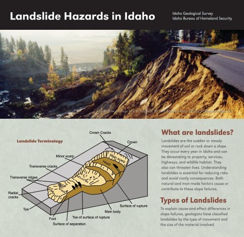
Landslide Hazards in Idaho - Bureau of Homeland Security - Idaho ...
Landslide Hazards in Idaho - Bureau of Homeland Security - Idaho ...
Landslide Hazards in Idaho - Bureau of Homeland Security - Idaho ...

You also want an ePaper? Increase the reach of your titles
YUMPU automatically turns print PDFs into web optimized ePapers that Google loves.
<strong>Landslide</strong> <strong>Hazards</strong> <strong>in</strong> <strong>Idaho</strong><br />
<strong>Idaho</strong> Geological Survey<br />
<strong>Idaho</strong> <strong>Bureau</strong> <strong>of</strong> <strong>Homeland</strong> <strong>Security</strong><br />
Earth flow damage to U.S. Highway 95 near Bonners Ferry. (Photo: R. Breckenridge, IGS)<br />
Transverse ridges<br />
Radial<br />
cracks<br />
<strong>Landslide</strong> Term<strong>in</strong>ology<br />
Toe<br />
Transverse cracks<br />
M<strong>in</strong>or scarp<br />
Crown Cracks<br />
Head<br />
Ma<strong>in</strong> scarp<br />
Crown<br />
Surface <strong>of</strong> rupture<br />
Ma<strong>in</strong> body<br />
Foot<br />
Toe <strong>of</strong> surface <strong>of</strong> rupture<br />
Surface <strong>of</strong> separation<br />
What are landslides<br />
<strong>Landslide</strong>s are the sudden or steady<br />
movement <strong>of</strong> soil or rock down a slope.<br />
They occur every year <strong>in</strong> <strong>Idaho</strong> and can<br />
be devastat<strong>in</strong>g to property, services,<br />
highways, and wildlife habitat. They<br />
also can threaten lives. Understand<strong>in</strong>g<br />
landslides is essential for reduc<strong>in</strong>g risks<br />
and avoid costly consequences. Both<br />
natural and man-made factors cause or<br />
contribute to these slope failures.<br />
Types <strong>of</strong> <strong>Landslide</strong>s<br />
To expla<strong>in</strong> cause-and-effect differences <strong>in</strong><br />
slope failures, geologists have classified<br />
landslides by the type <strong>of</strong> movement and<br />
the size <strong>of</strong> the material <strong>in</strong>volved.
Slides consist <strong>of</strong> blocks <strong>of</strong> material mov<strong>in</strong>g on<br />
well-def<strong>in</strong>ed shear planes. They are divided <strong>in</strong>to<br />
rotational slides that move along a concave<br />
surface and translational slides that move<br />
parallel to the ground surface.<br />
Falls are the sudden release <strong>of</strong> rocks or soils<br />
dropp<strong>in</strong>g freely through the air with little contact<br />
with other surfaces until impact.<br />
Topples are similar to falls except that the <strong>in</strong>itial<br />
movement <strong>in</strong>volves a forward rotation <strong>of</strong> the mass.<br />
Flows move entirely by shear<strong>in</strong>g with<strong>in</strong> the<br />
transported mass and act like viscous fluids.<br />
Creep is the almost imperceptible movement <strong>of</strong><br />
material down a slope.<br />
Lateral spreads occur when liquefaction <strong>in</strong><br />
underly<strong>in</strong>g materials causes surface rocks or soils<br />
to move down gentle slopes.<br />
Lateral Spread<br />
Rotational<br />
<strong>Landslide</strong><br />
Translational<br />
<strong>Landslide</strong><br />
Lateral spread<br />
Rotational <strong>Landslide</strong><br />
Translational <strong>Landslide</strong><br />
Creep<br />
Topple<br />
Curved tree trunks<br />
Tilted pole<br />
Topple<br />
Soil ripples<br />
Fence out <strong>of</strong> alignment<br />
Creep<br />
Rockfall<br />
Rockfall<br />
Images adapted from USGS<br />
On October 16, 1998, this large<br />
earth flow near Bonners Ferry<br />
caused extensive damage to<br />
U.S. Highway 95 and Union<br />
Pacific railroad tracks. Trucks,<br />
tra<strong>in</strong>s, school buses, and<br />
emergency services were<br />
blocked for several weeks<br />
caus<strong>in</strong>g severe economic losses.<br />
The flow occurred when highway<br />
construction undercut slopes<br />
composed <strong>of</strong> water saturated<br />
glacial and lake sediments. The<br />
deposits were formed dur<strong>in</strong>g the<br />
last ice age when glaciers and<br />
large lakes covered much <strong>of</strong> the<br />
<strong>Idaho</strong> panhandle.<br />
Photo: Jim Van Sky, Big Country Helicopters
Photo: IBHS<br />
Debris flow damage to road caused by heavy w<strong>in</strong>ter precipitation<br />
on the Middle Fork Boise River near Atlanta.<br />
Causes <strong>of</strong> <strong>Landslide</strong>s<br />
<strong>Landslide</strong>s are caused by gravity act<strong>in</strong>g on slopes.<br />
When gravitational stresses exceed the strength <strong>of</strong><br />
rock or soil, slope failure occurs. Many landslides are<br />
<strong>in</strong>itiated by trigger<strong>in</strong>g factors that <strong>in</strong>crease stress and<br />
weaken slope materials. These triggers <strong>in</strong>clude:<br />
• Heavy ra<strong>in</strong>s, rapid snowmelt, or irrigation that load<br />
slopes with water<br />
• Natural erosion or human activities that <strong>in</strong>crease<br />
slope angles or undercut the toes <strong>of</strong> slopes<br />
• Shak<strong>in</strong>g by earthquakes<br />
• Removal <strong>of</strong> vegetation by wildfire, logg<strong>in</strong>g,<br />
agriculture, or overgraz<strong>in</strong>g<br />
• Load<strong>in</strong>g <strong>of</strong> slopes with piles <strong>of</strong> rock, ore,<br />
or m<strong>in</strong><strong>in</strong>g waste<br />
Photo: J. Pierce, Boise State University<br />
Photo: R.B. Colton, USGS<br />
Debris flow deposits along Fourth <strong>of</strong> July Creek, near<br />
Stanley. The forest was burned by wildfire <strong>in</strong> the fall<br />
<strong>of</strong> 2006.<br />
Lateral spreads at Hebgen Lake near West Yellowstone. Shak<strong>in</strong>g<br />
from the August 18, 1959 magnitude 7.3 Hebgen Lake earthquake<br />
caused liquefaction <strong>of</strong> sediments beneath the road.
<strong>Landslide</strong>s and Geology<br />
Certa<strong>in</strong> comb<strong>in</strong>ations <strong>of</strong> earth materials and steep topography<br />
<strong>in</strong>crease the likelihood <strong>of</strong> slope failure. In <strong>Idaho</strong>, examples<br />
<strong>in</strong>clude basalt with sedimentary <strong>in</strong>terbeds, altered volcanic<br />
rocks, fractured metamorphic rocks, glacial and lake deposits,<br />
and weathered granite.<br />
Basalt lava flows exposed<br />
<strong>in</strong> canyons hundreds <strong>of</strong><br />
feet deep occur throughout<br />
the Snake River Pla<strong>in</strong> and<br />
Columbia Plateau. Large<br />
landslides tend to form where<br />
the basalts are underla<strong>in</strong> by<br />
unconsolidated sediments.<br />
In some cases, irrigation<br />
<strong>in</strong>creases the landslide<br />
potential. At Salmon<br />
Falls Creek south <strong>of</strong> Buel,<br />
translational and rotational<br />
slides and multiple lateral<br />
spreads have occurred where<br />
basalt overlies lake and<br />
fluvial sediments.<br />
In the Lost River<br />
Range near Mackay,<br />
steeply dipp<strong>in</strong>g,<br />
altered volcanic<br />
rocks flowed out<br />
<strong>of</strong> the canyon onto<br />
the valley floor to<br />
form this prehistoric<br />
debris flow. The<br />
volcanic rocks were<br />
altered by hot fluids<br />
that reduced their<br />
strength. Shak<strong>in</strong>g<br />
from earthquakes<br />
along nearby faults<br />
may also have<br />
played a role <strong>in</strong><br />
caus<strong>in</strong>g this huge<br />
slope failure.<br />
Photo: G. Meyer, University <strong>of</strong> New Mexico<br />
Photo: B. Bannon, <strong>Idaho</strong> Transportation Department<br />
On steep slopes <strong>in</strong> <strong>Idaho</strong>’s river canyons, metamorphic rocks<br />
fractured by fault<strong>in</strong>g and fold<strong>in</strong>g are prone to fail as falls, topples,<br />
and translational slides. Such landslides are common along the<br />
Salmon River and <strong>in</strong> Hells Canyon. This landslide near Lucille on<br />
the Salmon River was sporadically active between 1996 and 2005,<br />
sometimes bury<strong>in</strong>g both lanes <strong>of</strong> U.S. Highway 95.<br />
These slope failures along the South Fork <strong>of</strong> the Payette River were<br />
triggered <strong>in</strong> the w<strong>in</strong>ter <strong>of</strong> 1996-97 by <strong>in</strong>tense ra<strong>in</strong>fall on a heavy snow<br />
pack. The slopes are underla<strong>in</strong> by weathered granite. In 1989, the<br />
area was burned by wildfire.Granite covers much <strong>of</strong> central <strong>Idaho</strong>. It<br />
weathers <strong>in</strong>to marble-sized gra<strong>in</strong>s <strong>of</strong> quartz and feldspar called grus.<br />
When saturated by heavy precipitation from summer thunderstorms<br />
or prolonged w<strong>in</strong>ter ra<strong>in</strong>s, grus-covered slopes are prone to fail as<br />
debris flows. Removal <strong>of</strong> vegetation by wildfires or human activity<br />
exacerbates this situation.
Study<strong>in</strong>g <strong>Landslide</strong>s<br />
Scientific studies can identify landslide-prone areas and<br />
evaluate their risk. Large landslide complexes near Lewiston<br />
were identified by geological mapp<strong>in</strong>g. The slides formed<br />
along steep cliffs composed <strong>of</strong> basalt <strong>in</strong>terbedded with<br />
sedimentary deposits. Dur<strong>in</strong>g the last ice age, catastrophic<br />
floods deposited gravel and sand on the tops <strong>of</strong> landslides<br />
and eroded the toes <strong>of</strong> slopes. These long-ago events may<br />
have triggered <strong>in</strong>itial movements <strong>in</strong> the landslide complex.<br />
Between 1994-1998, a part <strong>of</strong> the slide directly below the Elks<br />
Lodge began to fail, threaten<strong>in</strong>g the build<strong>in</strong>g and temporarily<br />
block<strong>in</strong>g a major local road.<br />
Image: IGS<br />
Geologic map <strong>of</strong> Lewiston landslide<br />
Geologic map <strong>of</strong> the landslide complex. Qls: landslide deposits;<br />
Qcb: basalt; Ql: loess deposits; m: man-made land at Lewiston airport.<br />
Air photo <strong>of</strong> landslide complex along the Snake River near Lewiston.<br />
The landslide is outl<strong>in</strong>ed <strong>in</strong> red. Location <strong>of</strong> the geologic cross-section<br />
is shown by black l<strong>in</strong>e. The white build<strong>in</strong>g <strong>in</strong> lower left is the Elks<br />
Lodge, site <strong>of</strong> a smaller landslide.<br />
Image: IGS<br />
Photo: IBHS<br />
Rotational debris slide <strong>in</strong> May 1998 on the toe <strong>of</strong> the ma<strong>in</strong> landslide<br />
complex. <strong>Landslide</strong>s occurred <strong>in</strong>termittently <strong>in</strong> the area between<br />
1994-1998. Slid<strong>in</strong>g began after the road was widened at the toe<br />
<strong>of</strong> the slide. The white-ro<strong>of</strong>ed build<strong>in</strong>g is the Elks Lodge. The slide<br />
blocked a major local road and threatened to destroy the build<strong>in</strong>g.<br />
Geologic cross section <strong>of</strong> Lewiston landslide show<strong>in</strong>g basalts<br />
<strong>in</strong>terbedded with sediment and the steep slopes caused by<br />
fluvial erosion. Many landslides <strong>in</strong> the Lewiston area have this<br />
geological sett<strong>in</strong>g.
<strong>Landslide</strong>s and Floods<br />
Many landslides <strong>in</strong> <strong>Idaho</strong> occur dur<strong>in</strong>g or shortly after <strong>in</strong>tense<br />
storms that cause flood<strong>in</strong>g. These <strong>in</strong>clude thunderstorms <strong>in</strong><br />
the summer or autumn, and heavy w<strong>in</strong>ter ra<strong>in</strong>s fall<strong>in</strong>g over<br />
prolonged periods. Intense ra<strong>in</strong>fall fall<strong>in</strong>g on a thick snow<br />
pack and on lands recently burnt by wildfires are<br />
particularly dangerous.<br />
The connection between flood<strong>in</strong>g and landslides is illustrated<br />
by the events <strong>in</strong> the Boise foothills between 1959 and 1997.<br />
On August 19, 1959, a cloudburst <strong>in</strong> the Boise foothills created<br />
mud-rich floods that ran down streets and <strong>in</strong>to storm sewers,<br />
basements, and an <strong>Idaho</strong> National Guard armory. Nearly 500<br />
houses were damaged by mud up to 10 feet deep, and an area<br />
<strong>of</strong> over 160 acres was covered by silt. The source <strong>of</strong> the mud<br />
was easily erodible material on hillsides denuded <strong>of</strong> vegetation<br />
by a wildfire only three weeks before. In January 1969, a<br />
storm struck the same area and caused extensive damage,<br />
mostly from deposits <strong>of</strong> sediment. On September 11, 1997, a<br />
cloudburst dropped 0.40 <strong>in</strong>ch <strong>of</strong> ra<strong>in</strong> <strong>in</strong> n<strong>in</strong>e m<strong>in</strong>utes <strong>in</strong> the<br />
same foothills burned by a 1996 wildfire. The result<strong>in</strong>g flood <strong>of</strong><br />
mud and debris damaged several homes and an elementary<br />
school. Presently, Boise operates sediment control structures<br />
on the dra<strong>in</strong>ages that were <strong>in</strong>volved <strong>in</strong> these events. The<br />
structures are designed to channel flood water and mud away<br />
from residential and bus<strong>in</strong>ess districts <strong>in</strong>to hold<strong>in</strong>g ponds and<br />
onto play<strong>in</strong>g fields.<br />
Reduc<strong>in</strong>g <strong>Landslide</strong> Losses<br />
• Learn to recognize exist<strong>in</strong>g landslides and<br />
landslide-prone areas.<br />
• Avoid build<strong>in</strong>g on or near steep slopes.<br />
• Many landslides occur dur<strong>in</strong>g high <strong>in</strong>tensity ra<strong>in</strong>fall<br />
or prolonged periods <strong>of</strong> w<strong>in</strong>ter ra<strong>in</strong>. Monitor news<br />
media for current conditions and check with the <strong>Idaho</strong><br />
Transportation Department for road closures from<br />
landslides.<br />
• Be especially alert when travel<strong>in</strong>g. Bridges may be<br />
washed out or damaged, and culverts filled with debris.<br />
Never drive over flooded roads or across streams.<br />
• Be aware that debris flow hazards may <strong>in</strong>crease<br />
follow<strong>in</strong>g wildfires because <strong>of</strong> the loss <strong>of</strong> vegetation.<br />
Flood control structures along Cottonwood Creek <strong>in</strong> Boise. Debris<br />
from Cottonwood Creek is routed <strong>in</strong>to sediment retention pond and,<br />
if necessary, onto park<strong>in</strong>g lot and play<strong>in</strong>g fields.<br />
For Further Information<br />
<strong>Idaho</strong> Geological Survey<br />
PO Box 443014<br />
University <strong>of</strong> <strong>Idaho</strong><br />
Moscow, ID 83844-3014<br />
Phone: (208) 885-7991<br />
E-mail: igs@uidaho.edu<br />
Website: www.idahogeology.org<br />
<strong>Idaho</strong> <strong>Bureau</strong> <strong>of</strong><br />
<strong>Homeland</strong> <strong>Security</strong><br />
4040 Guard Street, Bldg. 600<br />
Boise, ID 838705-5004<br />
Phone: (208) 422-3040<br />
Website: www.bhs.idaho.gov<br />
W. Phillips, D. Garwood, and R. Stewart, 2008, <strong>Landslide</strong> <strong>Hazards</strong> <strong>of</strong><br />
<strong>Idaho</strong>: <strong>Idaho</strong> Geological Survey GeoNote G-44.