Sunrise Park Property Concept Plan - City of Tigard
Sunrise Park Property Concept Plan - City of Tigard
Sunrise Park Property Concept Plan - City of Tigard

You also want an ePaper? Increase the reach of your titles
YUMPU automatically turns print PDFs into web optimized ePapers that Google loves.
Site Analysis<br />
An analysis <strong>of</strong> the site was conducted to determine<br />
the opportunities afforded and constraints<br />
imposed by existing site conditions. A primary goal<br />
<strong>of</strong> the site analysis was to identify potential access<br />
connections, and to explore ways to effectively<br />
integrate the site into regional objectives for park<br />
amenities and trail networks.<br />
Land Use<br />
The <strong>Sunrise</strong> <strong>Property</strong> is nestled in a residential<br />
area <strong>of</strong> single-family homes and heavily wooded<br />
areas. It is zoned R-7, in which “Community<br />
Recreation” is permitted as a conditional<br />
use according the <strong>Tigard</strong> Development Code.<br />
Properties east and west <strong>of</strong> the site are also zoned<br />
R-7, and properties north and south <strong>of</strong> the site are<br />
in unincorporated Washington County.<br />
Slope Analysis<br />
The site has a steep elevation change falling<br />
approximately 200 feet from south to north.<br />
Elevations range from a high point <strong>of</strong> 630 feet<br />
along the east/west portion <strong>of</strong> <strong>Sunrise</strong> Lane<br />
to a low <strong>of</strong> 430 feet in the wooded area to the<br />
north. Areas <strong>of</strong> steep slopes (>25%) exist along<br />
the northern and eastern property edges. The<br />
southern third <strong>of</strong> the site has rolling topography,<br />
with vistas to the north and northwest.<br />
Resource Assessment<br />
A wetland determination and delineation<br />
conducted by Schott & Associates for DR Horton,<br />
Inc. shows a 0.05-acre (2,005 sf) sloped wetland<br />
exists near the property’s northwest corner. It lies<br />
within a depression flanked by steep slopes in a<br />
heavily wooded area.<br />
connections to these valuable recreational assets<br />
will firmly integrate the <strong>Sunrise</strong> property into<br />
the <strong>City</strong>’s parks and trail system. Connections to<br />
the Cach area and Westside trail will open access<br />
to the expansive residential neighborhoods that<br />
surround the site in all directions.<br />
Streets<br />
<strong>Sunrise</strong> Lane is classified as a Local Street with<br />
a standard right-<strong>of</strong>-way width <strong>of</strong> 46 feet and<br />
a paved width <strong>of</strong> 24 feet. SW 150th Avenue<br />
is classified as a Neighborhood Street with a<br />
standard right-<strong>of</strong>-way width <strong>of</strong> 50 to 58 feet<br />
and a paved width <strong>of</strong> 28 to 36 feet. Currently,<br />
however, no sidewalk or planter strip exists along<br />
these streets and the width <strong>of</strong> street pavement<br />
currently ranges from approximately 12 to 18<br />
feet.<br />
Utilities<br />
Access to water and electrical service are<br />
available near the site along <strong>Sunrise</strong> Lane, but<br />
sanitary and stormwater systems are not present<br />
on <strong>Sunrise</strong> Lane.<br />
Site Character<br />
The steep slopes on site will impact earthwork<br />
and views to and from the site. The varied<br />
vegetation <strong>of</strong>fers opportunities for different<br />
experiences and levels <strong>of</strong> comfort. The sun<br />
orientation will influence plant selection and<br />
placement. Prevailing winds will help determine<br />
locations for shelters and seating. Specific design<br />
decisions in response to these site characteristics<br />
are discussed in the <strong>Concept</strong> <strong>Plan</strong> section.<br />
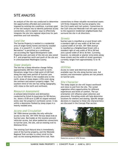
Access and Circulation<br />
SW 150th Avenue provides the only vehicular<br />
access to the site. SW 147th Terrace dead ends at<br />
<strong>Sunrise</strong> Lane. Barricades at this location prevent<br />
vehicular access, but allow pedestrian connections<br />
to <strong>Sunrise</strong> Lane, the site, and an existing trail to<br />
Mistletoe Drive.<br />
The existing Cach Natural Area is immediately<br />
west <strong>of</strong> the <strong>Sunrise</strong> property, and the Westside<br />
Regional Trail corridor is a short stroll to the<br />
east via the existing Mistletoe Drive trail. Path<br />
Pedestrian access at 147th Terrace.<br />
4<br />
<strong>Sunrise</strong> <strong>Park</strong> <strong>Property</strong> | <strong>Concept</strong> PLAN | June 6, 2013