METRES - Bookshelf Collection - The University of Auckland
METRES - Bookshelf Collection - The University of Auckland
METRES - Bookshelf Collection - The University of Auckland

You also want an ePaper? Increase the reach of your titles
YUMPU automatically turns print PDFs into web optimized ePapers that Google loves.
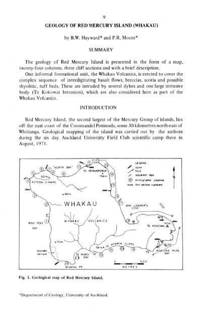
GEOLOGY OF RED MERCURY ISLAND (WHAKAU)<br />
9<br />
by B.W. Hayward* and P.R. Moore*<br />
SUMMARY<br />
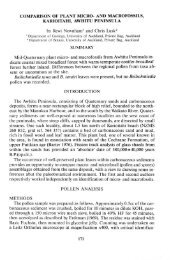
<strong>The</strong> geology <strong>of</strong> Red Mercury Island is presented in the form <strong>of</strong> a map,<br />
twenty-four columns, three cliff sections and with a brief description.<br />
One informal formational unit, the Whakau Volcanics, is erected to cover the<br />
complex sequence <strong>of</strong> interdigitating basalt flows, breccias, scoria and possible<br />
rhyolitic, tuff beds. <strong>The</strong>se are intruded by several dykes and one large intrusive<br />
body (Te Kokowai Intrusion), which are also considered here as part <strong>of</strong> the<br />
Whakau Volcanics.<br />
INTRODUCTION<br />
Red Mercury Island, the second largest <strong>of</strong> the Mercury Group <strong>of</strong> islands, lies<br />
<strong>of</strong>f the east coast <strong>of</strong> the Coromandel Peninsula, some 30 kilometres north-east <strong>of</strong><br />
Whitianga. Geological mapping <strong>of</strong> the island was carried out by the authors<br />
during the six day <strong>Auckland</strong> <strong>University</strong> Field Club scientific camp there in<br />
August, 1971.<br />
WHAKAU PT. M E T R E S<br />
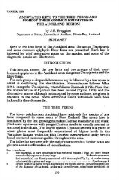
Fig. 1. Geological map <strong>of</strong> Red Mercury Island.<br />
*Department <strong>of</strong> Geology, <strong>University</strong> <strong>of</strong> <strong>Auckland</strong>.
10<br />
PREVIOUS WORK<br />
Little previous work has been done on the island.<br />
Thompson (1966) and Sch<strong>of</strong>ield (1967) placed the rocks <strong>of</strong> Red Mercury<br />
Island within the andesitic Beesons Island Volcanics. In the course <strong>of</strong> mapping<br />
all the islands in the Mercury Group in 1968, Drs. D.N.B. Skinner and R.N.<br />
Brothers made a short survey <strong>of</strong> Red Mercury. <strong>The</strong> results <strong>of</strong> this programme are<br />
expected to be published shortly in Skinner's N.Z. Geological Survey Bulletin<br />
on the geology <strong>of</strong> the Northern Coromandel Peninsula (Dr. D.N.B. Skinner,<br />
pers. comm.).<br />
PHYSIOGRAPHY<br />
Red Mercury Island, 2.6 kilometres across at its widest part, forms a slightly<br />
dissected raised tabular block sloping gently southwards. Except for Te Roroi<br />
Bay and the southern end <strong>of</strong> Rolypoly Bay, the entire island is bounded by steep<br />
cliffs, in places up to 100 metres high. <strong>The</strong> highest point, Te Rengarenga;<br />
(154 metres A.S.L.), occurs above the northern cliffs and from here most <strong>of</strong> the<br />
island's streams flow southwards, subparallel with the overall slope <strong>of</strong> the<br />
topography.<br />
Boulder beaches occur around much <strong>of</strong> the island and an extensive boulder<br />
flat, approximately two to three metres above sea level, is preserved at the<br />
southern end <strong>of</strong> Rolypoly Bay.<br />
Almost all information was collected from cliff sections, as rock exposure<br />
inland was poor and limited to occasional unvegetated patches exposing highly<br />
weathered flows and breccias.<br />
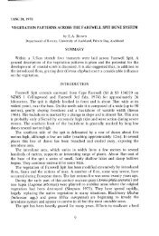
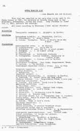
Fig. 2. Western stack (approx 30m high), Ngatoka Puta<br />
Bay. Sketch shows south-easterly striking dykes cutting<br />
massive breccia and thin flows; a wall <strong>of</strong> columnar >— V"jointed<br />
basalt forms the western face. <strong>The</strong> margin ^-O^g<br />
<strong>of</strong> the Te Kokowai Intrusion is exposed in the £%<br />
lower portions <strong>of</strong> the eastern face.
11<br />
STRUCTURE<br />
<strong>The</strong> flows, breccias and tuff beds that constitute the bulk <strong>of</strong> Red Mercury<br />
Island generally have a dip <strong>of</strong> from 2° to 15° in a southerly or westerly direction.<br />
Several dyke complexes and the Te Kokowai Intrusion, penecontemporaneous<br />
with the emplacement <strong>of</strong> the uppermost flows, intrude the lower sequence <strong>of</strong><br />
the Whakau Volcanics. <strong>The</strong>se dyke complexes, situated on either side <strong>of</strong> Te<br />
Rengarenga headland and in Ngatoka Puta Bay (fig. 1), generally consist <strong>of</strong> one<br />
or more major dykes that <strong>of</strong>ten give rise to several secondary <strong>of</strong>fshoots. No dyke<br />
exceeds three metres in thickness and most are between one and two metres<br />
thick; the majority are vertical or near vertical and <strong>of</strong>ten somewhat sinuous.<br />
A textbook example <strong>of</strong> a dyke, two metres thick, vertical and striking 115°,<br />
is located in Ngatoka Puta Bay. Here it extends from the cliff out through the<br />
shore platform as a natural jetty and into the nearby stack where it forms a<br />
striking wall <strong>of</strong> horizontal columns (fig.2).<br />
SECTION A-A<br />
Ngatoka Puta Bay<br />
dykes<br />
numerous trim flows i9S»*<br />
and scoria bands<br />
SECTION B-B'<br />
thick bush<br />
...„ i £ • -<br />
Te Kokowai Intrusion '<br />
Te Kokowai Intrusion<br />
thick bush<br />
-X) metres<br />
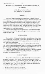
Fig. 4. Cliff sections from Ngatoka Puta Bay to Von Luckner's Cove.<br />
V o n<br />
Luckner's<br />
Cove<br />
weathered flows<br />
and scoria 1<br />
Numerous dykes were seen to extend into the overlying scoria and flows from<br />
the Te Kokowai Intrusion (fig.4) and to feed sills or flows above. <strong>The</strong> Te<br />
Kokowai Intrusion forms the lower twenty to fifty metres <strong>of</strong> the north eastern<br />
portion <strong>of</strong> Te Kokowai. At the contact in the eastern end <strong>of</strong> Von Luckner's<br />
Cove, the Intrusion appears to have baked and disrupted the flows and breccias,<br />
while in Ngatoka Puta Bay it appears to have squeezed in between flows and<br />
incorporated large blocks <strong>of</strong> country rock (fig.3).
12<br />
Faults were rarely observed on the island but three subvertical fractures<br />
exist in Ngatoka Puta Bay, striking approximately NNW and with one to six<br />
metres downthrow to the west.<br />
One cliff section <strong>of</strong> particular interest is that on the east coast <strong>of</strong> Te Renga-<br />
renga in section C — C (fig.5). Here a large mass <strong>of</strong> basaltic lava (c'), 200 metres<br />
across and 30 metres high, conformably overlies a tuff bed, breccias and flow c.<br />
This mass (c') is subhorizontal with a comparatively flat upper surface and very<br />
steep (50 — 60°) irregular sides. This upper surface is overlain by a tuff bed<br />
that is semi-continuous down the sides, where it has accumulated in irregular<br />
hollows. On either side <strong>of</strong> c' the overlying tuff bed is directly on top <strong>of</strong>, and<br />
conformable with, the tuff bed that underlies c'.<br />
Because there is no evidence <strong>of</strong> erosion or intrusion, it can only be assumed<br />
that c' was emplaced in its present form as a huge ejected volcanic plug, or more<br />
likely as an extremely viscous lava flow, c' is <strong>of</strong> considerable importance when<br />
considering the sequence <strong>of</strong> events during the emplacement <strong>of</strong> the lower Whakau<br />
Volcanics sequence, as the character <strong>of</strong> the flows and breccias to the east is<br />
is markedly different from that to the west (see Stratigraphy).<br />
SECTION c-c Te Rengarenga<br />
Fig. 5. Detailed cliff section around Te Rengarenga.<br />
STRATIGRAPHY<br />
Red Mercury Island is composed <strong>of</strong> a complex sequence <strong>of</strong> interstratified<br />
basalt flows, breccias, scoria and tuff beds, intruded by dykes and the Te<br />
Kokowai Intrusion, that together comprise what is here termed the Whakau<br />
Volcanics. <strong>The</strong> authors consider that this informal formational unit cannot be<br />
correlated with the andesitic Beesons Island Volcanics or any other recognised<br />
unit.<br />
<strong>The</strong> island was circumnavigated by boat and on foot and the entire cliff<br />
exposure mapped. Twenty-four stratigraphic columns have been constructed
13<br />
to illustrate the sequence (figs.6,7,8). Correlation <strong>of</strong> flows around the northern<br />
cliffs, from column 1 through to 18, is possible due to continuous exposure.<br />
Because <strong>of</strong> the boulder terrace at Rolypoly Bay and the Te Kokowai Intrusion<br />
however, these flows cannot be correlated accurately across to the southern<br />
coastal cliffs <strong>of</strong> Te Atiaroa and Whakau Point (columns 19 to 24).<br />
Description <strong>of</strong> Columns<br />
(a) Von Luckner's Cove to Te Rengarenga (figs.5,7).<br />
In Von Luckner's Cove (column 18) numerous irregular interlensing flows,<br />
breccias, scoria bands and tuff beds dip at some 10° west, away from an inferred<br />
9<br />
f<br />
'V"-"-<br />
Bay - bos art flows<br />
"* - ^<br />
A<br />
7<br />
-i A<br />
-<br />
9<br />
i<br />
? —<br />
?<br />
tuff beds<br />
/<br />
flay<br />
t<br />
'I<br />
f<br />
7<br />
7<br />
1<br />
( 1<br />
* * • I*<br />
~ - * -<br />
t y t<br />
19994<br />
e /<br />
** * "a<br />
*«* * a<br />
t<br />
/ 1<br />
d c<br />
'?,
14<br />
centre <strong>of</strong> volcanicity <strong>of</strong>f Ngatoka Puta Bay. <strong>The</strong>se flows flatten <strong>of</strong>f to subhorizontal<br />
to the north west and extend as far as column 14 where they abut<br />
against c' (see Structure and fig.5). This body, c', effectively divides the northern<br />
cliff section into two parts. To the south-east the flows are thin, irregular and<br />
<strong>of</strong>ten discontinuous, with thick rubbly breccia and tuff beds between; the flows<br />
themselves <strong>of</strong>ten grade into breccia bands. Because <strong>of</strong> the complex nature <strong>of</strong><br />
this sequence it was impossible to accurately sketch and correlate all these flows,<br />
but a sample section immediately south <strong>of</strong> c' was sketched to illustrate their<br />
structure (fig.5).<br />
Correlation from one side <strong>of</strong> c' to the other is facilitated by tuff beds and the<br />
overlying flow g. A tuff bed that immediately underlies c' is overlain on either<br />
side by further tuff that is seen to pass over the top <strong>of</strong> c'. This particular bed can<br />
be traced from column 18 in Von Luckner's Cove through to column 11 in<br />
"North Bay" (fig.7). Two other tuff beds can be traced from the sequence in<br />
Von Luckner's Cove over the top <strong>of</strong> c' and into the sequence in "North Bay".<br />
One <strong>of</strong> these, between flows e and f, can be traced right around Koterai-o-maru<br />
to column 1 in Rolypoly Bay, while the other, beneath flow g, can be traced from<br />
column 17 in Von Luckner's Cove to column 10 in "North Bay".<br />
Flow g extends from Von Luckner's Cove (column 18) to "North Bay"<br />
(column 8), and thickens westward from 6 metres to a maximum <strong>of</strong> some 50<br />
metres beneath Te Rengarenga (column 15). Thickness decreases to 20 metres<br />
in column 8 and the flow has been removed by erosion further west on Koteraio-maru.<br />
(bjTe Rengarenga to Rolypoly Bay (figs. 6,7).<br />
To the west <strong>of</strong> c' the flows are fewer in number, more distinct and thicker,<br />
correlation being aided by this less complex structure. A maximum <strong>of</strong> seven<br />
flows is shown in column 10. Flows a and b are only exposed in the lower<br />
eastern portion <strong>of</strong> the "North Bay" cliff section (columns 10 and 11), while<br />
flow c, underlying c' in columns 12 and 13, and varying in thickness from 10<br />
to 20 metres, can be traced continuously, except for a short gap in "North<br />
Bay", from Te Rengarenga to Koterai-o-maru (column 4).<br />
Flows d and e, like flows u and w in Te Atiaroa Cliffs, lens out to the west in<br />
the cliffs approaching Koterai-o-maru, and in doing so they grade into thick<br />
breccia and scoria layers that also decrease in thickness and lens out to the west.<br />
Flow f can be traced from c' through to column 1 in Rolypoly Bay and has a<br />
fairly constant thickness <strong>of</strong> some 20 to 30 metres.<br />
All these flows are separated by breccia or scoriaceous bands and/or tuff beds.<br />
(cj Ngatoka Puta Bay to Whakau Point (figs. 4,8).<br />
Numerous thin westerly-dipping flows and interbedded scoria bands are<br />
exposed in the cliffs <strong>of</strong> Ngatoka Puta Bay. Twenty-three separate flows (0.3 to<br />
4 metres thick) were counted in one sixty metre high cliff exposure, and these<br />
flow flatten from approximately 14° to 3° westerly dip within a distance <strong>of</strong><br />
200 metres to the west.<br />
<strong>The</strong> exact relationship <strong>of</strong> the Ngatoka Puta Bay flows to those in the Te<br />
Atiaroa Cliffs is not clear due to thick vegetative cover between the two areas.
<strong>The</strong> authors infer, however, that as the flows flatten to the west they thicken up<br />
or lens out to form the sequence <strong>of</strong> flows shown in columns 19 to 24.<br />
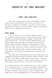
Seven different flows (t to z) were mapped in the Te Atiaroa Cliffs. Two <strong>of</strong><br />
these flows u and w, lens out to the west (fig.8), and together with the<br />
decreasing attitude <strong>of</strong> the flow, provide evidence for a centre <strong>of</strong> volcanism to<br />
the east, <strong>of</strong>f Ngatoka Puta Bay. Flow v can be traced continuously, except for a<br />
short gap across Te Roroi Bay, from column 19 to 24 and provides a good<br />
reference plane for the remainder <strong>of</strong> the flows.<br />
15<br />
Red and yellow tuffs beds arc sparse in the Te Atiaroa Cliffs and discontinuous,<br />
occuring only as elongate pods interbedded with the breccias between flows.<br />
(d) Te Kokowai (fig.4).<br />
<strong>The</strong> Te Kokowai Intrusion underlies a sequence that contains abundant<br />
scoria bands, in places up to 20 metres or more thick. Flows are sparse in the<br />
immediate 40 metres above the instrusion but are more numerous forming the<br />
cap on Te Kokowai itself.<br />
Bare patches <strong>of</strong> reddish clay, derived from the weathering <strong>of</strong> the red scoria<br />
and baked tuff beds, on the western side <strong>of</strong> Te Kokowai were once quarried by<br />
the Maoris. It is from this activity that Te Kokowai was named (kokowai =<br />
red ochre).<br />
Whakau Point Te Atiaroa Cliffs<br />
Fig. 8. Stratigraphic columns, Whakau Pt. and Te Atiaroa Cliffs. For locations see Fig. I.<br />
Holocene Deposits<br />
An extensive boulder terrace, two to three metres high, occupies the southern<br />
end <strong>of</strong> Rolypoly Bay and is probably a remnant <strong>of</strong> the Flandrian Transgression.<br />
This is slightly higher than usual Flandrian terraces but may be explained in that<br />
storm wave and talus built boulder terraces are <strong>of</strong>ten higher than normal<br />
coastal terraces. Other than the boulder beaches that' surround the island,<br />
there are no other Holocene deposits <strong>of</strong> note.
16<br />
Genesis <strong>of</strong> Whakau Volcanics Clastic Deposits<br />
(a) Breccias<br />
<strong>The</strong> breccias that lie between the flows may be heterogenetic, but the majority<br />
appear to have a direct origin in the lava flows, to which they are petrographi-<br />
cally similar. Moreover, the lava flows were <strong>of</strong>ten observed to lens out and<br />
break up into breccias.<br />
Flows <strong>of</strong>ten have a layer <strong>of</strong> breccia directly above and below, with red<br />
scoria or tuff beds between. <strong>The</strong> authors envisage that the viscous lava broke up<br />
into angular blocks around the margins as it flowed, rafting along and over<br />
riding the breccias, while the slower cooling central portion <strong>of</strong> the flow remained<br />
intact as a coherent mass.<br />
(bj Scoria<br />
In the course <strong>of</strong> mapping, distinction between scoria and breccia was <strong>of</strong>ten<br />
found difficult especially where these were weathered. Consequently, the<br />
symbols used on the stratigraphic columns may not give an accurate picture <strong>of</strong><br />
the distribution and relationships <strong>of</strong> the scoria bands.<br />
Although some <strong>of</strong> the scoria interbedded with flows in the Te Rengarenga -<br />
Koterai-o-maru section may have been directly deposited subaerially, it seems<br />
likely that a proportion was later rafted along by the flows. This hypothesis may<br />
also explain such features as the scoria and breccia pods or lenses in the lava<br />
flows <strong>of</strong> Whakau Point.<br />
At Te Kokowai a sequence <strong>of</strong> scoria bands and thin flows overlying the Te<br />
Kokowai Intrusion appears to be the remnant <strong>of</strong> a once more extensive scoria<br />
cone, presumably built around a centre <strong>of</strong>f Ngatoka Puta Bay.<br />
(c) Tuff Beds<br />
Laminated tuff beds, varying in thickness from 1 cm up to 3 metres, show<br />
few <strong>of</strong> the features typical <strong>of</strong> aqueous deposition and were probably all subaerially<br />
deposited. <strong>The</strong> even distribution <strong>of</strong> ash over such steep sided features<br />
as c' (see structure) makes the idea <strong>of</strong> aqueous deposition unacceptable.<br />
In places these tuff beds are separated into two or even three bands by<br />
lensing lava flows and associated breccias, indicating that they were deposited<br />
from a series <strong>of</strong> ash showers over a period <strong>of</strong> time.<br />
In numerous places the heat <strong>of</strong> the overlying flows has baked the tuff beds,<br />
and in Rolypoly Bay the fine-grained tuffs under-lying flow f (column 2) have<br />
been baked to an extremely hard orange-red brick.<br />
PETROGRAPHY<br />
Specimen numbers are those <strong>of</strong> the petrological collections <strong>of</strong> the Department<br />
<strong>of</strong> Geology, <strong>University</strong> <strong>of</strong> <strong>Auckland</strong>.<br />
Whakau Volcanics<br />
(a) Dykes, Flows and Breccias<br />
Nine representative specimens <strong>of</strong> dykes and flows were selected for thin
17<br />
sectioning and examination. Specimens 19985 to 19988 are from four major<br />
dyke localities (fig. 1) and specimens 19993 to 19997 are from five different<br />
flows exposed at various points around the island. Modal analyses from thin<br />
sections <strong>of</strong> the four dykes and three <strong>of</strong> the flows are presented in Table 1.<br />
TABLE 1: Modal analyses <strong>of</strong> Whakau Volcanics' thin sections.<br />
Sect inn Number<br />
Flows: % % * * % * * % * % * *<br />
19993 (flow h) 47.4 44.3 1.1 1.3 52.6 26.6 21.4 2.9 1.7 70.9 22.7<br />
19994 mow c) 37.9 33.9 3.4 06 62.1 32.3 22.6 5.2 2 0 66.2 23.2<br />
19995 (now f) 14.5 10 0 4.5 85.5 51.1 18.1 9 3 7 0 62.1 18 1<br />
Dykes:<br />
19985 19 8 116 6.8 1.4 80.2 53.2 13.6 1.3 0.8 113 64.8 14.0<br />
19986 16.0 109 4.0 11 84.0 53 4 22.6 3.3 4.7 64.3 23.7<br />
19987 35.5 30.9 5.0 0.6 64.5 29.0 25.1 3 8 3.7 1.9 59 9 25.7<br />
19988 7.6 2.9 4.7 92.4 57 8 25.8 3 1 5.7 60.7 25.8<br />
19984 5.2 1.3 3.9 94.8 21.1 0.8 0 7 4.6 67.5<br />
I 1,000 points per section,<br />
micro<br />
t 2. Crystals whose maximum dimension was less than 0.3 mm were counted as groundmass.<br />
Pheno " Phenocryst; Plag. • Plagioclase; 01. = Olivine; Cpx. = Clinopyroxene; Gmass = Groundmass; Micro • Microliter; Opaq = Opaques; Alk. fetds. -<br />
Alkali feldspars; Indel gmass = Indeterminate groundmass (less than 0 01 mm maximum dimension).<br />
In hand specimens the breccia blocks, flows and dykes are similar and vary<br />
from light purplish to grey in colour. <strong>The</strong>y contain numerous small creamywhite<br />
plagioclase feldspar and orange-brown altered olivine phenocrysts, with<br />
largest dimension <strong>of</strong> 2mm. Samples vary from vesicular to non-vesicular.<br />
In thin section the rocks are porphyritic, with plagioclase feldspar, olivine<br />
and rare clinopyroxene phenocrysts. Rare glomerophenocrysts <strong>of</strong> clinopyroxene,<br />
plagioclase and olivine occur in several sections. <strong>The</strong> groundmass texture in the<br />
flows is generally intergranular, but in the two thicker flows sectioned the<br />
texture verges on pilotaxitic (19995) and subophitic (19996). In the dykes the<br />
groundmass texture is more variable, ranging from the strongly pilotaxitic<br />
(19988) to the subophitic (19987) and the intergrannular to weakly pilotaxitic<br />
(19985 and 19986).<br />
All sections, except for 19988, contain between 10 and 45% euhedral to<br />
subhedral stubby, twinned and <strong>of</strong>ten zoned plagioclase feldspar phenocrysts.<br />
<strong>The</strong>se phenocrysts are <strong>of</strong>ten poikilitic, containing granules <strong>of</strong> devitrified glass<br />
and opaques.<br />
Two to seven percent <strong>of</strong> the bulk composition <strong>of</strong> all sections are composed <strong>of</strong><br />
subhedral olivine phenocrysts, ranging from 0.2 to 2.0mm diameter. <strong>The</strong>se<br />
olivine phenocrysts are always rimmed or even completely replaced by goldenbrown<br />
deuteric iddingsite.<br />
Sparse subhedral, weakly pleochroic light green-brown clinopyroxene phenocrysts<br />
occur in most sections.<br />
A noncrystalline groundmass <strong>of</strong> slender plagioclase feldspar microlites.
18<br />
anhedral clinopyroxene crystals, opaques and alkali feldspar constitutes between<br />
52 and 93% <strong>of</strong> the bulk composition <strong>of</strong> all sections. Small anhedral clinopyroxene<br />
crystals and opaques, <strong>of</strong> less than 0.3mm diameter, fill the angular interstices<br />
between the plagioclase microlites. <strong>The</strong> <strong>of</strong>ten indistinguishable colourless alkali<br />
feldspar occurs as a late crystallising phase in cavities between the plagioclase<br />
and clinopyroxene crystals.<br />
Coarseness and groundmass constituents is highly variable, with microlites<br />
generally less than 0.3mm in length, although 19987, with subophitic texture,<br />
contains some up to 0.6mm long.<br />
basalt.<br />
Rock type for all flows and dykes examined is considered to be an olivine<br />
(b) Tuff Beds<br />
Three samples from the tuff beds were examined. Colours vary from<br />
whitish through red-brown to dark brown, though all appear to be <strong>of</strong> similar<br />
composition. <strong>The</strong> whitish sample, however, consists <strong>of</strong> what seems to be highly<br />
weathered pumiceous material, with common euhedral to anhedral opaques<br />
and rare quartz grains. Some relatively unweathered darker scoriaceous fragments<br />
are also present.<br />
<strong>The</strong> other two samples consist largely <strong>of</strong> whitish and grey to red-brown rock<br />
fragments, <strong>of</strong>ten very glassy and vesicular, and common feldspar phenocrysts<br />
and abundant colourless to white glassy shards. <strong>The</strong> remaining fragments<br />
consist <strong>of</strong> both black and red-brown glass in varying amounts, minor black ores,<br />
and rare quartz grains. <strong>The</strong> red-brown glass shows a "grain" or sheen similar to<br />
that found in some <strong>of</strong> the obsidians <strong>of</strong> Mayor Island (pers. obs.).<br />
(c) Te Kokowai Intrusion<br />
One fresh specimen (19984) <strong>of</strong> the Te Kokowai Intrusion was sectioned and<br />
examined. <strong>The</strong> modal analysis is presented in Table 1. In hand specimens the<br />
sample is indistinguishable from the flows and dykes. It is light grey, vesicular,<br />
and with golden-brown phenocrysts <strong>of</strong> altered olivine, <strong>of</strong> maximum dimension<br />
1.5mm, scattered throughout.<br />
In thin section the rock is porphyritic although the phenocrysts, mostly<br />
iddingsite pseudomorphs after olivine, comprise only 5% <strong>of</strong> the bulk composition.<br />
Stubby subhedral poikilitic plagioclase phenocrysts are rare.<br />
<strong>The</strong> groundmass has an intergranular to intersertal texture <strong>of</strong> which 70%<br />
is indeterminable fine grained material <strong>of</strong> less than 0.01mm diameter. Slender<br />
plagioclase microlites, 0.05 to 0.2mm long, are the coarsest and most common<br />
groundmass mineral indentifiable, with very fine grained crystals <strong>of</strong> clinopyroxene<br />
rarely discernible. Opaques are in minor proportions, and small<br />
patches <strong>of</strong> alkali feldspar occur as late crystallising groundmass cavity fillings.<br />
GEOLOGICAL HISTORY<br />
During an undetermined period in Pliocene and/or lower Pleistocene, the<br />
Whakau Volcanics were erupted onto a terrestrial surface. <strong>The</strong> nearest centre <strong>of</strong><br />
activity appears to have been <strong>of</strong>f Ngatoka Puta Bay where a considerable
quantity <strong>of</strong> scoria, together with interbedded thin flows, formed a small cone.<br />
Further from this centre, viscous basaltic aa lava flowed over and rafted along<br />
breccias and scoria forming a complex interdigitating sequence.<br />
During the course <strong>of</strong> eruption <strong>of</strong> the basalt flows, laminated tuffs were<br />
deposited within the sequence, the ash possibly coming from a distant rhyolitic<br />
eruptive centre on Great Mercury Island or the Coromandel Peninsula.<br />
Intrusion <strong>of</strong> dykes and the Te Kokowai Intrusion, occurred during the later<br />
stages <strong>of</strong> activity and the observed faults were probably associated with the<br />
emplacement <strong>of</strong> the Te Kokowai Intrusion.<br />
<strong>The</strong> south sloping surface <strong>of</strong> Red Mercury and the apparent overall southerly<br />
dip <strong>of</strong> flows suggests post-volcanic tilting occurred. No direct evidence for uplift<br />
or for major <strong>of</strong>fshore faulting was found, but these processes may have also<br />
played a major role in the history <strong>of</strong> Red Mercury.<br />
Since the cessation <strong>of</strong> volcanism, erosion has been most marked around the<br />
coast with fluviatile erosion <strong>of</strong> only minor importance in shaping the island's<br />
present physiography.<br />
<strong>The</strong> higher sea level <strong>of</strong> the post-glacial Flandrian transgression was responsible<br />
for the formation <strong>of</strong> a 2-3 metre boulder terrace at Rolypoly Bay.<br />
19<br />
ACKNOWLEDGEMENTS<br />
<strong>The</strong> authors wish to thank Dr R.N. Brothers and Mr J.A. Grant-Mackie for<br />
critically reading the manuscript.<br />
REFERENCES<br />
Sch<strong>of</strong>ield, J.C. 1967 Sheet 3, <strong>Auckland</strong>. "Geological Map <strong>of</strong> N.Z." 1:250,000.<br />
Thompson, B.N. 1966 Geology <strong>of</strong> the Coromandel Region. N.Z.G.S. Report 14.<br />
Skinner, D.N.B. (in press) Geological map <strong>of</strong> N.Z. 1:63,660. Part sheets N35, 36, 39<br />
and sheet N40. Northern Coromandel.<br />
(in prep) Aspects <strong>of</strong> the Cenozoic geology <strong>of</strong> northern Coromandel.<br />
Bull. N.Z.G.S.