Welland Canal - City of Port Colborne
Welland Canal - City of Port Colborne
Welland Canal - City of Port Colborne

You also want an ePaper? Increase the reach of your titles
YUMPU automatically turns print PDFs into web optimized ePapers that Google loves.
Weir Dam – Main Street<br />
The bridge was built as part <strong>of</strong> the fourth <strong>Welland</strong> <strong>Canal</strong>, replacing<br />
a swing bridge over the first, second, and third canals at the same<br />
site. The dam beneath this bridge regulates the amount <strong>of</strong> water<br />
downstream in the canal, including seven lift locks stretching to<br />
Lake Ontario and a hydro-electric generating plant at Decew Falls in<br />
St. Catharines.<br />
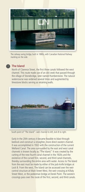
The railway swing bridge, built in 1880s, with Canadian National Railway<br />
marking on the side.<br />
The Island<br />
North <strong>of</strong> Clarence Street, the first three canals followed the west<br />
channel. This route made use <strong>of</strong> an old creek that passed through<br />
the village <strong>of</strong> Stonebridge, later named Humberstone. The natural<br />
watercourse was widened several times and augmented by<br />
limestone blocks serving as retaining walls.<br />
Weir dam at Main Street West.<br />
Lock 8 and Lock 8 Gateway Park<br />
Lock 8 on the east side <strong>of</strong> the Island serves as a guard lock for the<br />
canal, raising or lowering ships one to four feet, depending on the<br />
Lake Erie water levels. At 420 metres, it is one <strong>of</strong> the longest canal<br />
locks in the world. Being the southernmost lock on the present-day<br />
<strong>Welland</strong> <strong>Canal</strong>, many ships use time in the lock to have supplies<br />
replenished, switch crew, and undergo minor repairs.<br />
South point <strong>of</strong> “The Island”- weir channel to left, lock 8 to right.<br />
Early in the 20th century it became feasible to blast through<br />
bedrock and construct a straighter, more direct eastern channel.<br />
It was accomplished in 1932 with the construction <strong>of</strong> the current<br />
<strong>Welland</strong> <strong>Canal</strong>. The area surrounded by the east and west canal<br />
channels is known locally as “The Island.” It was created by the<br />
cutting <strong>of</strong> the new fourth canal channel in the 1920s and the<br />
existence <strong>of</strong> the curved first, second, and third canal channels,<br />
thereby surrounding the entire area with water. Access to The Island<br />
from the east must be made by either <strong>of</strong> the jack-knife bridges at<br />
Lock 8. From the west, The Island can be accessed over the weir<br />
control structure at Main Street West, the weir crossing at Killaly<br />
Street West, or the pedestrian bridge at Derek Point. The western<br />
crossings pass over the route <strong>of</strong> the first, second, and third canals.<br />
Ship entering lock 8, under jack-knife bridge (Bridge 19).<br />
Lock 8 Gateway Park, adjacent to Lock 8 has an elevated viewing<br />
platform to watch ships enter and exit the lock. The single-leaf<br />
rolling bascule, or jack-knife bridges at each end provide vehicle<br />
access to “The Island” and the east and west sides <strong>of</strong> the <strong>City</strong>.