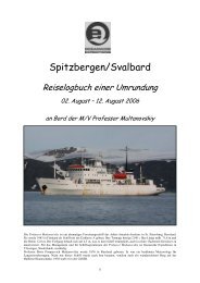
ÐÐ ÐÎÎΡÐÐ ÐÐÐ¥ÐÐÐ - Spitzbergen
ÐÐ ÐÎÎΡÐÐ ÐÐÐ¥ÐÐÐ - Spitzbergen
ÐÐ ÐÎÎΡÐÐ ÐÐÐ¥ÐÐÐ - Spitzbergen

You also want an ePaper? Increase the reach of your titles
YUMPU automatically turns print PDFs into web optimized ePapers that Google loves.
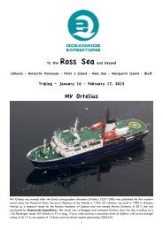
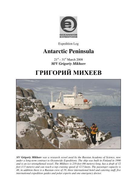
Expedition Log<br />
Antarctic Peninsula<br />
21 st – 31 st March 2008<br />
M/V Grigoriy Mikheev<br />
ГРИΓΟΡИЙ МИХЕЕВ<br />
MV Grigoriy Mikheev was a research vessel used by the Russian Academy of Science, now<br />
under a long-term contract to Oceanwide Expeditions. The ship was built in Finland in 1990<br />
and is an ice-strengthened vessel. The Mikheev is 210 feet (66 meters) long, has a draft of 12<br />
feet (3.5 meters) and can reach a top cruising speed of 12.5 knots. The passenger capacity is<br />
48, in addition there is a Russian crew of 19, three international hotel and catering staff, five<br />
international expedition guides and polar experts and one emergency doctor.
With<br />
Captain Andrey Khoroshaylov<br />
and his Russian Crew of 18<br />
including<br />
1 st Mate: Stanislav Nedelko<br />
2 nd Mate – Alexey Nazarov<br />
3 rd Mate – Alexander Nozdryukhin<br />
Radio Engineer - Zodiac Driver: Oleg Orlik<br />
Boatswain: Yuriy Sabol<br />
Able Seaman - Zodiac Driver: Dmitriy Ivanov<br />
Able Seaman - Zodiac Driver: Vitaliy Zuev<br />
Stewardess: Lina Tishchenko<br />
Stewardess: Nina Ivanova<br />
Stewardess: Yulia Tuchkova<br />
Stewardess: Elena Petrova<br />
Stewardess: Irina Kortikova<br />
and<br />
Expedition Leader – Rolf Stange (Germany)<br />
Dive Master/Lecturer– Jonas Sundquist (Sweden)<br />
Guide/Lecturer – Jordi Plana (Spain/Chile)<br />
Lecturer/Dive Master – Jonas Thormar (Denmark)<br />
Hotel Manager – Francis de Buck (Belgium)<br />
Head Chef – Tobias Fritz (Austria)<br />
Sous Chef – Beverly Howlett (Scotland)<br />
Ship’s Physician – Claudia Vernooij (The Netherlands)<br />
And 39 of us from Australia, Belgium, Canada, Germany, Ireland, The Netherlands,<br />
Russia, Spain, Sweden, the United Kingdom and the United States<br />
21st March 2008 – Ushuaia / Tierra del Fuego, Argentina<br />
16:00 Position 54°45' S / 68°30' W<br />
Air temperature: 12°C, nice and sunny.<br />
We landed in Ushuaia, the place which markets<br />
itself as “El Fin del Mundo” (The End of the<br />
World). The rugged spine of the Andes stretches<br />
the entire length of the South American continent, coming<br />
right down to meet the sea here at the southern tip of Chile<br />
and Argentina. The four-hour flight from Buenos Aires<br />
over the flat, dry Argentine Pampas and Patagonia was<br />
highlighted by the plane’s steep descent over the snow and<br />
glacier-capped peaks to the airstrip which projects straight<br />
out into the Beagle Channel. The scenery includes<br />
extensive fjords reminiscent of parts of Norway.<br />
At four in the afternoon the staff and crew were ready to<br />
welcome us on board, where we had time to find our<br />
cabins and to unpack and rest a little.<br />
At 5.20 p.m. we met in the dining room for the first time, where we were welcomed by Rolf Stange<br />
(Germany), our Expedition leader who gave us a short introduction to the ship, followed by Jonas<br />
2<br />
With a rapidly growing population of 55,000 people,<br />
Ushuaia is a flourishing duty free port with a fishing<br />
industry particularly famous for its crabs (centolla).<br />
There are other new industries as well, notably<br />
electronics. The new buildings and roads give the<br />
appearance of a latter day “frontier town” and one of<br />
the few remnants of the last century is a beautiful<br />
Victorian timber building right on the harbour. Its first<br />
owner purchased the so-called Casa Beban building<br />
through a catalogue over a hundred years ago. The<br />
museum in the former prison had a fascinating and<br />
well-arranged series of displays.
Sundquist, the divemaster, introducing himself and his dive guide Jonas from Denmark. The polar bug<br />
had long ago bitten all members of the expedition staff. Rolf trained as a geographer, is the author of<br />
several books and a seasoned guide and expedition leader in the Arctic, Antarctic and South Atlantic<br />
areas. The expedition team was completed by Jordi Plana from Spain/Chile, who was specialized in<br />
marine mammals and would guide as ashore.<br />
The hotel department on board the Grigoriy Mikheev was led by Francis de Buck from Belgium. The<br />
cooks, who would take care of tasty meals during our voyage, were Tobias Fritz (Austria) and Beverly<br />
Howlett (Scotland). Dr Claudia Vernooij, the ship’s physician, had been working and travelling with<br />
Oceanwide before, in Arctic waters, and therefore came with a wealth of knowledge about cold<br />
climate, emergency medicine and motion sickness remedies. But of course we hoped that we would<br />
meet her in the bar rather than in the hospital!<br />
Captain Andrey Khoroshlaylov was busy on the bridge, but we would see him later. He had an<br />
experienced crew of 18 Russian officers, sailors, engineers and service personnel on board.<br />
Our Antarctic adventure was about to start!<br />
Finally, the ships docking lines were hauled in at<br />
around 18:00 and we set sail out of the harbour in the<br />
most beautiful sunshine. Just after leaving, Stanislav<br />
Nedelko, our first officer, gave us an important safety<br />
briefing on the upcoming lifeboat drill. Shortly after,<br />
the ship’s alarm sounded a signal for us to practice this<br />
emergency evacuation drill. Moving to our cabins, we<br />
donned warm clothes and life jackets and proceeded to<br />
our muster station, near the lifeboats. Most of us<br />
completed the exercise by climbing inside the eggshaped<br />
lifeboats. We all felt quite safe inside, although<br />
certainly not overly comfortable, and happy to return to<br />
our cabins. Dinner awaited us, giving a chance for<br />
everybody to get a little more acquainted.<br />
22 nd March 2008 – Southbound in Drake Passage<br />
Position at 08.00h: 56°11’ S / 65°47’ W<br />
415 nm to the South Shetland Islands<br />
Air temperature: 10°C, overcast, wind force 6 and swell, cloud cover<br />
T<br />
oday we could relax and recover from our flights in the Drake Passage, which presented itself<br />
in an average mood, considering the season – a fact that did not keep some of us from not liking<br />
it.<br />
A first good Mikheev-style breakfast was followed by bridge excursions. Many of us had already<br />
signed up to be organized into smaller groups for this purpose, but the whole operation was condensed<br />
down into one group at least for the moment, as many of us had decided that bed was a better place to<br />
be due to the movement of the ship.<br />
3
In the afternoon, Jordi invited us for an introduction into the seabird world of the Southern Ocean.<br />
And indeed, we had already seen a veritable choice of these: the great Wandering Albatross was<br />
around our ship for most of the day, constantly accompanied by several smaller Black-browed<br />
Albatrosses and the odd Grey-headed Albatross, to mention the most important ones. Giant Petrels<br />
were seen several times, and smaller birds included Prions with their elegant, swallow-like flight.<br />
Even a first whale was seen in the afternoon, although it could not be identified.<br />
Later, "Jonas the incredible Swede" followed with an appetizer for diving at the cold ends of the<br />
world. In the evening, we rounded the day off in the Mikheev-cinema with the first part of Life in the<br />
Freezer. Our appetite for Antarctica grew with every mile that we sailed southwards!<br />
The Drake Passage<br />
The Drake Passage geologically opened about 22 to 30 million years ago, and connects the Atlantic<br />
with the Pacific Ocean, south of Tierra del Fuego. The South Shetland Islands lie south of this strait,<br />
which is here about 800-900 km wide. The Drake played an important part in the trade of the 19 th and<br />
early 20 th centuries before the opening of the Panama Canal in 1914. The stormy seas and icy<br />
conditions made the rounding of Cape Horn through the Drake Passage a rigorous test for ships and<br />
crews alike, especially for the sailing vessels of the day. Though bearing the name of the famous 16 th -<br />
century English seaman and explorer, the Drake Passage was, in fact, first traversed in 1616 by a<br />
Flemish expedition led by Willem Schouten. Sir Francis Drake sailed through the Straits of Magellan<br />
to the north of Tierra del Fuego, although he was subsequently blown south into the more extreme<br />
latitudes west of the passage by a Pacific storm. The passage has an average depth of 3400 m (11,000<br />
feet), with deeper regions of up to 4800 m (15,600 feet) near the northern and southern boundaries.<br />
The winds through the Drake Passage are predominantly from the west and are most intense in the<br />
northern half. The mean annual air temperature ranges from 5°C in the north to –3°C in the south.<br />
Cyclones (atmospheric low-pressure systems with winds that blow clockwise in the Southern<br />
Hemisphere) formed in the Pacific Ocean traverse the passage towards the southern end. Surface<br />
water temperature varies from near 6°C in the north to -1°C in the south, with the temperature altering<br />
sharply in a zone near 60°S. This transitional zone is known as the Antarctic Convergence, or Polar<br />
Front. It separates the sub-Antarctic surface water from the colder and fresher Antarctic surface<br />
water. At depths of between approximately 500 to 3000 m there occurs a layer of relatively warm and<br />
salty deep water. The maximum extent of sea ice occurs in September, when between 25% and 100%<br />
ice cover extends as far as 60°S. Ice floes occasionally reach Cape Horn.<br />
The water within the passage flows from the Pacific into the Atlantic, except for a small amount of<br />
water in the south that comes from the Scotia Sea. The general movement, know as the Antarctic<br />
Circumpolar Current, is the most voluminous in the world, with an estimated rate of flow between<br />
950 to 1500 Mio cubic metres per second.<br />
23 rd March 2008 – Southbound in Drake Passage<br />
Position at 08.00h: 59°25’ S / 62°04’ W<br />
215 nm to the South Shetland Islands<br />
Air temperature: 0°C, overcast, decreasing wind force 4 and swell, cloud cover<br />
Most of us would remember this night as a moving experience, as the swell had reached<br />
considerable size due to winds winds that reached more than 20 m/s during the early hours.<br />
Bed was certainly not a bed place to be under these conditions, and anybody who might<br />
have seen us from outside would probably have suspected us of major take of stimulating liquids – but<br />
really, the liquid that made us move was everywhere outside the ship, rather than inside.<br />
We had crossed the Antarctic convergence during the night, the invisible boundary zone that separates<br />
more temperate waters in the north from the cold Antarctic water body that surrounds the last<br />
continent. In other words: we had entered Antarctica, ecologically speaking. The political dimension<br />
followed soon, as we crossed 60°S during the day, thus entering the area that is governed by the<br />
Antarctic Treaty.<br />
Chess was played, books were read, birds were observed and lectures were attended during the day, as<br />
conditions calmed gradually down. Rolf called us together for a mandatory introduction to rules of<br />
Good Behaviour in Penguin Country ("IAATO-briefing") – after all, these polite creatures would meet<br />
us in in tailcoat, so we simply had to live up to Antarctic standards of etiquette. This, by the way, also<br />
4
included some remarks on distances that we had to keep and other measures to make sure we would<br />
not molest any wildlife and some important information to make sure our operation would be safe. He<br />
also added some information about our plans for the days to come.<br />
Jordi took over to give us an introduction to the Penguins of the Antarctic Peninsula, whom we were<br />
looking forward to meet during the days to come.<br />
After lunch, Rolf continued with an introduction to Plate Tectonics, a rather solid matter that was<br />
received warmly by those who were delighted by the thought of good, solid continental crust of<br />
granitic composition rather than the ever-moving liquid that we had everywhere around us. In the later<br />
afternoon, Jonas the Swede made sure the divers were updated with all information that was needed<br />
for the days to come, and even some non-divers (rumour had it that some evil soul would call them the<br />
"normal people") were said to have attended this event out of sheer curiosity for all the exotic gear that<br />
was to be used for purpose that no mere mortal could ever understand.<br />
Another good dinner and the next part of Life in the Freezer rounded the day off.<br />
24 th March 2008 – South Shetland Islands<br />
Position at 06.30h: 62°31’ S / 59°19’ W<br />
Drifting near Robert Island<br />
Air temperature: 0°C, gentle breeze, overcast<br />
We had spent several hours drifting near Robert Island during the early morning and the<br />
engines had just been restarted when Rolf's wake-up call sounded through the ship at 0630<br />
hours. We had an early breakfast, while the Grigoriy Mikheev was approaching an<br />
anchoring position near Aitcho Islands, a small archipelago situated in English Strait between Robert<br />
and Greenwich Islands. Aitcho Islands were named after the Hydrographic Office ("HO"). At 0830,<br />
the long-awaited moment had finally come: we were ready on the front deck, equipped with lifejackets,<br />
waterproof gear, warm clothes and rubber boots. Ready for action! Some of us kept a nervous<br />
eye on the weather, as the wind was gradually picking up and snow showers were blown across the<br />
ship as we boarded the Zodiacs. Some minutes later, we stepped ashore on a pebble beach to be<br />
greeted by small groups of Gentoo and Chinstrap Penguins. Large whalebones were bleaching under<br />
the Antarctic sky, and Skuas and<br />
White-faced Sheathbills were<br />
patrolling the scene, hoping for<br />
injured or sick penguins or carcasses.<br />
We investigated the beach and all of<br />
us had the pleasure to meet curius<br />
Penguins, who would just walk up to<br />
us. They could not read and did not<br />
know anything about the 5-metrerule!<br />
5
Most of us walked up a ridge and down to the shore on the other side of Aitcho Island, which was just<br />
a narrow Isthmus at this site. The strength of the wind was incredible on top of the ridge, and groups<br />
of Penguins were seeking shelter just under the ridge.<br />
Finally Rolf decided it was unwise to stay any longer, and after a somewhat choppy ride we were soon<br />
back on board the Grigoriy Mikheev to warm up in the bar. The windspeed at the ship had picked up to<br />
more than 20 m/s – a solid force 9 on the Beaufort scale! During our stay ashore, the ship's anchor had<br />
been dragging across the ground for almost half a mile and our Captain was quite relieved when the<br />
anchor was up again and the ship under<br />
steam.<br />
We were heading for Deception Island,<br />
about 50 nautical miles from here,<br />
hoping for better conditions there as it<br />
was pretty clear that Zodiac operations<br />
were not an option in these conditions.<br />
The weather chart looked quite<br />
frightening, featuring a strong lowpressure<br />
system – we were glad not to be<br />
out in the Drake Passage anymore! And<br />
the Barograph showed an interesting<br />
curve, that could best be described as a<br />
near-vertical drop.<br />
It was shortly after 15:00 that we passed below Neptune’s Bellows, the U-shaped bite in the cliffs<br />
from where, in 1820, the young Nathaniel Palmer, climbing for birds’ eggs, looked east and saw more<br />
land – which would turn out to be the Antarctic Peninsula, though he never claimed it as continental<br />
land; he was not an explorer, but a sealer. Gerlache would eventually name this part of the mainland<br />
Palmer Land. Captain Khoroshaylov took us safely through the channel between Cathedral Crags,<br />
towering to our right, and the hidden menace of Ravn Rock to our left, which had snared the whaler<br />
Southern Hunter still visible on the shore on our port side, after running aground on 21 December<br />
1956. Deception Island itself was named by Palmer who had nearly given up being able to land when<br />
he found the entrance into Port Foster, a natural harbour almost as big as Rio de Janeiro’s.<br />
A turn to starboard brought us into Whaler’s Bay. Deception is a microcosm of the different phases of<br />
use and occupation of Antarctica. First came sealers, and then early scientists and whalers, who left the<br />
rusting remains of Hektor Whaling Station in the centre of the bay. The first Antarctic flights were<br />
made in 1929 when Hubert Wilkins flew a Lockheed Vega over the Peninsula. The aircraft hangar to<br />
the left of the other relics was built later by the British Antarctic Survey. More scientists were hot on<br />
their heels, and later spies and tourists. The first international football match in the last continent was<br />
played here: the English<br />
crew of HMS Snipe beat the<br />
Argentine crew of the<br />
Seaver by 1-0: one of the<br />
more peaceful disputes<br />
between the two countries.<br />
The drama of the scenery<br />
was unmissable, and we<br />
savoured the excitement of<br />
navigating across one of<br />
Antarctica’s most famous<br />
locations, a caldera which is<br />
still volcanically active.<br />
6
Soon, the anchor went down, and<br />
despite of a still considerable<br />
breeze and near-horizontal<br />
precipitation including both rain<br />
and snowfall, it did not take long<br />
until we found ourselves in the<br />
Zodiacs again. The "dry folks", as<br />
Rolf would occasionally refer to<br />
the non-divers, although we were<br />
soon to be anything but dry during<br />
this rather wet landing, had the<br />
opportunity to join Jordi on a hike<br />
up to the famous gap in the cliffs at<br />
the southern end of Whaler's Bay<br />
that is called Neptune's Window,<br />
and we had plenty of time to<br />
explore the remains of the old stations: the British "Base B" established during Operation Tabarin<br />
(named after a night club in Paris) in the late years of the Second World War and the above-mentioned<br />
Norwegian whaling station. It was fascinating to walk around between all the remains – truly an openair<br />
museum of Antarctic history! We were also amazed and amused by the number of Gentoo<br />
Penguins that crowded the shoreline.<br />
This was also the time for the first dive, the dive that so many of us have been looking forward to for<br />
almost a year. Two zodiacs, marked number one and three, slowly headed for the beach. There were<br />
16 of us that had come down here to dive and to our help we had the dive master Jonas Sundquist from<br />
Sweden (later known as “the Barbarian”) and the dive guide Jonas Thormar from Denmark (later<br />
know as “the Viking”).<br />
Whaler’s bay is a perfect spot for the first mandatory check-up dive. The bay is partially sheltered<br />
from the wind, the “warm” water at Deception Island (+3˚C) gives us a nice and comfortable<br />
introduction to the Antarctic waters and the sloping bottom is covered with black lava sand that makes<br />
it easy to enter the water and to gear up. It also brings a certain atmosphere to the site. The dive site it<br />
self doesn’t offer that much to see when it comes to critters and vegetation but that was quickly<br />
compensated by the small groups of penguins that joined us during the dive. It took a few minutes<br />
before all of us had sorted out the gear and started to get comfortable and properly weighted in the<br />
water but once that was ok we could all enjoy the first dive…and the penguins that were swimming<br />
around like rockets in the water. What a start to this adventure…<br />
Once we were all back on board again, the Captain took us safely through Neptune's Bellows once<br />
again, and during dinner we set course for Antarctica proper, the peninsula and near-by islands further<br />
south.<br />
25 th March 2008<br />
Antarctica: Enterprise Island, Wilhelmina Bay, Errera Channel: Cuverville Island/Danco Island<br />
Position at 07.00h: 64°26’ S / 61°51’ W<br />
8 nm to Enterprise Island<br />
Air temperature: -2°C, strong wind<br />
We woke up to witness an amazing scenery when Rolf's wake-up call sounded through the<br />
ship at the rather merciful time of 07:00. Completely ice-covered islands were not far, and<br />
behind it all, the mighty, ice-capped mountain range of the Antarctic peninsula. We were<br />
still steaming down the Gerlache Strait, the southern continuation of the Bransfield Strait (between the<br />
South Shetlands and the Antarctic Peninsula), approaching this morning's destination, and it did not<br />
take long after breakfast until we were ready to start. Anchored in Plata Passage, the northern<br />
continuation of Wilhelmina Bay, on the eastern side of Enterprise Island and Nansen Island, we were<br />
delighted to see that the relative protection of this area was indeed enough to provide shelter from the<br />
strong winds of the more open Gerlache Strait. A short Zodiac ride took us to a sheltered cove with the<br />
wreck of the Governor, a whaing ship that caught fire and sank in 1916. From there on, we kept<br />
exploring the coastline and small off-lying islands and, most importantly, a number of grounded<br />
7
icebergs, including some<br />
real beauties with deepblue<br />
stripes in sunshine!<br />
The unexpectedly good<br />
weather conditions<br />
allowed us to complete a<br />
circumnavigation of<br />
Enterprise Island, and our<br />
Zodiac cruise lasted for<br />
almost 2 ½ hours until<br />
we were finally back on<br />
board the Grigoriy<br />
Mikheev – a fine<br />
achievement that<br />
included a full load of<br />
Antarctic experience.<br />
Once the non-divers<br />
(some like to call them<br />
the normal people…)<br />
had left the ship and<br />
disappeared behind the<br />
icebergs it was time<br />
for us divers (also<br />
referred to as the<br />
pirates) to enter the<br />
zodiacs and head of to<br />
Foyn Harbour for a<br />
wreck dive on “the<br />
Governor”.<br />
The wreck is beautifully stranded in a small sheltered bay that normally offers excellent diving<br />
conditions. The wreck beautifully rests on the sloping bottom of the bay with it’s bow sticking up<br />
above the surface and the propeller located at 20 meters depth. On both sides of the wreck you can<br />
find whalebones and vertebrates lying on the bottom together with 35-armed sea stars, brittle stars, and<br />
other various forms of critters. The dive was nice and calm and we already seemed to be coping well<br />
with the cold water. A wreck dive in Antarctica … this was certainly something to tell your diving<br />
buddies at home!<br />
We still had some time before lunch, so we enjoyed the passage of the ship through Plata Passage and<br />
the extremely scenic Wilhelmina Bay, where we saw several Humpback whales peacefully swimming<br />
between the icebergs.<br />
Soon after lunch, we were anchored near Cuverville Island near the Errera Channel.<br />
The scenery was amazing, flat calm waters, the sun trying to break through over the glaciers and the<br />
amazing silence, the kind of silence you only can get in Antarctica. It was time for dive number three<br />
and for us divers to experience some classic iceberg diving, and maybe even a leopard seal or two. Our<br />
dive master, Jonas “the incredible Swede”, had a good feeling about some close encounters and<br />
thoroughly scouted the area for potential icebergs. After rejecting a few of them that didn’t meet the<br />
standards he finally found the perfect iceberg. It was a quite low, but fairly big and very beautiful<br />
iceberg that was grounded at about 20 meters depth. A few meters below the surface there were some<br />
nice shelves and overhangs that looked like potential leopard seal hide-outs … this was it! Some of us<br />
pirates were going to get the thrill of our lifetime; we just didn’t know it yet.<br />
It only took about two minutes from the time the last buddy team descended until a large female<br />
leopard seal was scouted at the surface. As customary for that situation the amount of bubbles<br />
dramatically increased at the surface … there were some serious air sucking going on around the<br />
iceberg and this seal really gave us a taste of what it’s like to dive with this amazing creature. The tale<br />
even tells stories about some nibbling going on under water …<br />
After a while some of us had had enough and returned to the surface, some more pale than others, but<br />
we we’re all happy. We just had our first encounter with a leopard seal … and what an encounter!<br />
8
A several mile long but very enjoyable Zodiac ride that included some stops near icebergs brought us<br />
– the "dry folks" – to Danco Island, where we landed on a convenient gravel beach to be welcomed by<br />
a large number of Gentoo Penguins. We were surprised by the number of animals that were still<br />
present so late in the austral summer, and we enjoyed the presence of these curious and friendly<br />
creatures.<br />
Some of us enjoyed the wildlife on the<br />
beach and slowly ventured across the<br />
gravel plain to the eastern side of the<br />
island to see the panorama of the near-<br />
9
y Antarctic peninsula, but most chose to join Jordi for a hike to the top of the island, over rocky<br />
slopes to an altitude of approximately 1200 decimetres – where were the oxygen bottles! The<br />
panorama view over the whole Errera Channel was more than a reward for the climb.<br />
The way back to the ship had even more excitements to offer. Some of us spotted some more<br />
Humpback whales, and one Zodiac encountered no less than about 20 Crabeater seals near an iceberg,<br />
most of them swimming – an unusually high number.<br />
Spirits were high during dinner, when we were discussing today's adventures and they grew to even<br />
higher levels when Rolf outlined our plans and hopes for tomorrow, including the option to send<br />
postcards from the museum at Port Lockroy – which would have to spend the winter in Antarctica<br />
before the postman would come to collect them in November!<br />
26 th March 2008<br />
Antarctica: Port Lockroy/Damoy Point, Neumayer Channel, Paradise Bay<br />
Position at 07.00h: 64°49’ S / 63°30’ W<br />
At anchor at Port Lockroy<br />
Air temperature: 0°C, calm, mostly cloudy<br />
We had spent a<br />
calm night at<br />
anchor in the<br />
protected little bay of Port<br />
Lockroy, between<br />
Wiencke and Anvers<br />
Islands. Today, the divers<br />
were the first ones to<br />
leave, to give them enough<br />
time to complete their<br />
operations at Damoy<br />
Point, while the "normal<br />
people" went ashore on<br />
tiny Goudier Island. Damoy Point is a very nice place for wall diving and it’s located just around the<br />
corner from Port Lockroy, only a few minutes from where the ship anchors. The site was almost fully<br />
protected in the lee of the shoreline and those of us pirates that chose to skip the visit to museum in<br />
favour of the dive geared up and slipped into the cold waters, ready for an interesting “critter” dive.<br />
The attention of the divers<br />
were quite quickly drawn<br />
away from the critters<br />
though and tended to be<br />
shifted towards the female<br />
leopard seal that had decided<br />
to join in on the fun. For the<br />
rest of the dive the seal was<br />
very inviting and generous<br />
and occasionally the seal<br />
would leave one buddy team<br />
to join another, just to make<br />
sure that all divers got a fair<br />
share of the encounter. It was<br />
an absolutely fantastic dive<br />
and most of us felt a little bit<br />
more secure and better<br />
prepared for the rendez-vous<br />
than we did on the last dive.<br />
10
The historic British ‘Base A’, Port Lockroy, is located at 64°49’S, 63°29’ W on the tiny Goudier<br />
Island, just off Wiencke Island, on the Antarctic Peninsula. The Base has been designated as an<br />
Historic Site and Monument under the Antarctic Treaty. It is owned by the UK Natural Environment<br />
Research Council, of which the British Antarctic Survey (BAS) is a component body. It is operated by<br />
the BAS during the austral summer under the guidance of the UK Antarctic Heritage Trust (AHT), and<br />
is currently one of the most visited sites in Antarctica.<br />
History<br />
During the Second World War, the British Government dispatched a secret mission, code-named<br />
‘Operation Tabarin’, to establish small bases on the Antarctic Peninsula. Its task was to report on<br />
enemy activities and to gather meteorological data. ‘Base A’, Port Lockroy, was built on Goudier<br />
Island in February 1944. Some of the timber used in the construction of the building was salvaged<br />
from the abandoned whaling station at Deception Island. The eight man wintering team was led by<br />
Commander James Marr, who, as a young Boy Scout, first visited Antarctica under the leadership of<br />
Sir Ernest Shackleton.<br />
After the war, the base was handed over to the civilian Falkland Islands Dependencies Survey (FIDS),<br />
which became the major international scientific organisation that is now the British Antarctic Survey<br />
(BAS). From 1948, the station played an important scientific role, including the first measurements of<br />
the ionosphere, and the first recording of an atmospheric whistler, over Antarctica. Port Lockroy was a<br />
key monitoring site during the International Geophysical Year of 1957/58. When BAS re-located its<br />
science to other sites on the Antarctic Peninsula, the base closed in January 1962 and subsequently fell<br />
into disrepair.<br />
Following a conservation survey by the UK Antarctic Heritage Trust (UK AHT) in 1994, Port<br />
Lockroy was recognised for its historical importance and designated as Historic Site and Monument<br />
No. 61 under the Antarctic Treaty. A conservation team undertook the renovation in 1996.<br />
Wildlife<br />
Between 700-800 pairs of Gentoo Penguins (Pygoscelis papua) nest on Goudier Island. The<br />
population, and breeding success, of this colony is monitored by BAS (see below).<br />
Small numbers of Snowy sheathbills (Chionis alba) also breed on Goudier Island, and Dominican<br />
gulls (Larus dominicanus) and Subantarctic skuas (Catharacta skua) nest on the nearby Bills Island.<br />
Blue-eyed shags (Phalacrocorax atriceps) and Antarctic terns (Sterna vittata) breed at Jougla Point,<br />
and Crabeater seals (Lobodon carcinophagus) also breed locally at Port Lockroy.<br />
Environmental Monitoring<br />
When the base re-opened in 1996, an environmental monitoring programme was established to<br />
investigate potential visitor disturbance to the resident colony of gentoo<br />
penguins on Goudier Island. Results show that the large numbers of visitors have had no discernable<br />
impact on penguin breeding success, which is more closely linked to local environmental conditions,<br />
such as snow cover or the availability of krill.<br />
11<br />
The "normal people"<br />
enjoyed not only the<br />
museum, but also the<br />
extremely friendly wildlife<br />
on Goudier Island in shape<br />
of sociable Gentoo Penguins<br />
and curious White-faced<br />
Sheathbills. And on top of it,<br />
the sun was bathing the<br />
whole scenery with mighty<br />
glaciers all around us with its<br />
warm rays! This was
Antarctica as we<br />
had been dreaming<br />
of it for a long time.<br />
But it was not over<br />
yet for the morning.<br />
We boarded the<br />
Zodiacs and a few<br />
minutes later we<br />
were surprised to<br />
find ourselves not<br />
on the ship, but on<br />
Jougla Point, a<br />
rocky headland just<br />
across the bay from Goudier Island and part of Wiencke Island. Next to even more Gentoo Penguins,<br />
we had free access to the "Jougla Point Whale Biology Open Air Museum": earlier visitors had put a<br />
complete whale skeleton together from bones that whalers had left behind about one century ago!<br />
Although there was no absolute certainty regarding the species – it might have been a Humpback<br />
Whale or a Southern Right Whale – and we were told that it was very likely to be a composite of<br />
skeleton remains of several individual animals, we were quite impressed by the size the animal once<br />
must have had and many photos were taken. Finally, it was time to return to the ship, as we still had<br />
plans before lunch: a passage through the very scenic Neumayer Channel between Wiencke and<br />
Anvers Islands, a passage that took almost one hour and it was hard to come down to the restaurant in<br />
the end. During lunch, we crossed Gerlache Strait once again and entered one of the most scenic and<br />
famous places of Antarctica: Paradise Bay (officially Paradise Harbour). Mighty, glacier-covered<br />
mountains were towering around this protected bay.<br />
The Shag wall, located just next<br />
to the former Argentinean base<br />
Amirante Brown, in Paradise<br />
Harbour, was the chosen location for the afternoon dive. A<br />
sloping wall filled with sponges, all kinds of critters,<br />
nudibranches, kelp, gorgonians and loads of other nice stuff.<br />
Despite a leaking dry suit and some glove problems it was a<br />
very good dive. The silence and the tranquillity of the bay<br />
were overwhelming and once the dive was finished all pirates<br />
set foot on the continent at the Argentinean base. Champagne<br />
was passed around to cheer the moment and before stepping<br />
into the zodiacs again for a cruise amongst the glaciers and<br />
icebergs, pictures were taken, snowballs were thrown, snow<br />
angels were made and Jonas “the Barbarian“ challenged the<br />
divers to a snow ball fight… None of the divers were brave<br />
enough to accept the challenge though so “the Barbarian”<br />
easily won the fight by walk over. “Take all you can…give<br />
nothing back!”<br />
The zodiac cruise offered mirror like waters and<br />
icebergs in multiple colours and we took the opportunity<br />
to sit still and listen to the silence for a few minutes with<br />
12
our engines shut off.<br />
At the end of the<br />
cruise we went over to<br />
an amazing glacier<br />
rippled with deep blue<br />
ice and the whole<br />
scenery was reflected<br />
in the calm waters. It’s<br />
easy to understand<br />
why this bay is called<br />
Paradise harbour…<br />
Just when we turned<br />
around our zodiacs to<br />
head back for the ship<br />
to get out of our suits<br />
and, a huge piece of<br />
the glacier came loose<br />
and fell into the water with a roaring sound, wiping out the reflection of the glacier in the<br />
water… It had been a grrreeeaaat day!<br />
At the same time, the land-lovers found themselves in the Zodiacs again to explore the place. We<br />
made a brief stop at the Argentine station Almirante Brown, that had been abandoned for a couple of<br />
years but rumour had it that it was planned to be re-opened and indeed those who knew the site could<br />
see that some construction work had been done recently. Just around the corner was a steep cliff with a<br />
colony of Blue-eyed shags, some of which were still at home, and with some interesting colouration:<br />
orange lichens and blueish-green copper-bearing<br />
minerals.<br />
But the highlight without any doubt was<br />
Skontorp Cove, a side branch of Paradise Bay. It<br />
seemed as if nature had put all its considerable<br />
powers into the creation of one of the most<br />
beautiful and impressive places one could<br />
possibly imagine. Heavily crevassed glaciers<br />
crept down steep, dark rockwalls to form high,<br />
broken ice-cliffs at sea level, ready to calve new<br />
icebergs at any time. We kept a respectful<br />
distance, but for the time being the glaciers<br />
remained calm. Nevertheless, we could witness<br />
13
another powerful part of the chain that transports ice from mountain tops down to sea level:<br />
repeatedly, pieces of an overhanging ice cliff at the plateau-shaped summit of a mountain not too far<br />
from the coast broke off to form white avalanche clounds, and we were happy to witness this from a<br />
safe distance.<br />
We continued our cruise between some icebergs to arrive at a rocky headland on the southern side of<br />
Paradise Brown, on the corner between Skontorp Cove and Oscar Cove. It was a nice place at<br />
64°55'S/62°53'W, lost in the middle of nowhere, framed in between large glaciers, where we stepped<br />
ashore to set foot on the last continent: Antarctica! From here, the South Pole could be reached on<br />
foot, a walk of 2,787 km (1,732 statute miles) as the crow flies. A piece of cake! Only the steep,<br />
avalanche-swept slopes of the surrounding mountains kept us from conquering the Pole from here. As<br />
it was, we turned out attention towards a Weddell Seal that was lazing around on the rocks, not really<br />
paying too much attention to us, before we were surprised with champagne and a toast to one of our<br />
fellow passengers who had had the pleasure of celebrating her birthday during this voyage!<br />
We did not forget<br />
to take a group<br />
photo and finally<br />
made our way<br />
back to the ship,<br />
not without saying<br />
hellow to some<br />
considerable time for a Zodiac cruise in<br />
these temperatures, and we were happy to<br />
get warm again in the bar or under the<br />
shower – but what did cold feet matter in<br />
the light of the experience that we just had<br />
enjoyed It would not take us longer than<br />
some minutes to get warm again, but the<br />
memories would last for a lifetime.<br />
In the evening, the ship moved out of<br />
Paradise Bay with its drifting icebergs to<br />
anchor south of the Neumayer Channel<br />
near Wauwermans Islands to spend a<br />
calm, safe night. For all of us who could<br />
still take some more Antarctic experience,<br />
Life in the Freezer was continued in the<br />
Mikheev-cinema.<br />
14<br />
Crabeater Seals<br />
who were enjoying<br />
life, lying in the<br />
sun on a bergy bit<br />
(a small iceberg).<br />
We had been out<br />
for almost 2 ½<br />
hours again, a<br />
27 th March 2008<br />
Antarctica: Lemaire Channel, Argentine Islands/Vernadsky Base, Pleneau Island/Booth Island<br />
Position at 07.00h: 64°54’ S / 63°45’ W<br />
At anchor at Wauwermans Islands (south of Neumayer Channel)<br />
Air temperature: 0°C, breeze, cloud cover<br />
D<br />
uring breakfast, we were already sailing again, further south towards the southernmost<br />
position of our voyage. As soon as we left the restaurant, the Grigoriy Mikheev entered the<br />
famous Lemaire Channel. With the Antarctic Peninsula towering on portside (left side, east)<br />
and Booth Island (maximum elevation 980 metres) on starboard, the passage was only a few hundred<br />
metres wide and about 7 nautical miles long. It seemed almost as if it was blocked by a group of
icebergs, but a gap opened as we got closer. Several Humpback whales were searching the icy waters<br />
for food.<br />
South of the Lemaire Channel, we entered a wider strait called Penola Strait where even more whales<br />
were seen, including a distant pod of Orkas. We set course for a small group of rocky islands called<br />
Argentine Islands and at 10:00, the anchor went down. It was here the Ukranian station Vernadsky<br />
was situated. It was originally established after the Second World War a few hundred metres south of<br />
its present-day position, but had been moved later and named Faraday Station, run by the British<br />
Antarctic Survey (BAS), until it was sold to Ukraine in 1996 for one Pound Sterling – a bargain for<br />
both sides, as BAS was thus relieved from the obligation of removing everything after abandoning the<br />
station, while the Ukranians wished to have a station in Antarctica at the same time. Faraday was<br />
crucial in the discovery of a regular depletion of the stratospheric ozone layer that is commonly<br />
referred to as the "ozone hole", and it has one of the longest continuous meteorological records of the<br />
Antarctic Peninsula. The continuation of these important data series alone, that are invaluable when<br />
climate change is discussed, would fully justify running the station which was renamed Vernadsky by<br />
the Ukranians, but there is more work going on including marine biology, geoelectricity and<br />
seismology. In recent years, Vernadsky produced amongst others data the suggested at an early stage<br />
that a seismic shock that originated in southeastern Asia was indeed coming from a nuclear explosion<br />
in North Korea, and meteorological data have shown a regional warming of almost 5°C between the<br />
late 1950's and present time!<br />
Being faced with<br />
such dramatic<br />
evidence during<br />
our guided tour<br />
through the<br />
laboratories of Vernadsky base, we decided to retreat to<br />
the famous Faraday bar and recharge our batteries with<br />
some strong liquids offered by the friendly station staff.<br />
The station stamp was busily used and postcards were<br />
sent.<br />
We did not miss the opportunity to visit Wordie House, a<br />
few hundred metres further south at 65°15'S/64°16'W and<br />
thus the absolute furthest south position of our voyage!<br />
Wordie House was the original station building and served<br />
now as a museum, nicely kept to demonstrate how life in<br />
the early days of systematic research in Antarctica might<br />
have been. We also explored the surrounding ice-free part<br />
of the small island and enjoyed the view across Penola<br />
Strait to the Antarctic Peninsula, before we boarded the<br />
Zodiacs once again, cruising through a narrow channel<br />
with a dramatic ice cliff towering above us, and returning<br />
to the ship, where we found that waves at the gangway had<br />
reached considerable height, but all of us managed this<br />
challenge well with the help and advice of the crew and staff operating the boats and the gangway.<br />
Next to the option of a station visit, the area offers great wall diving with all kinds of critters, sponges,<br />
anemones, antarctic cod, nudibranches, estrella stars and much more. The two Zodiacs anchored just<br />
opposite the station and the divers rolled back into the water, buddy team by buddy team. Even though<br />
leopard seals are often spotted at this site, once back into the Zodiacs again the divers were quite<br />
15
happy that no leopard seal paid a<br />
visit on this dive. It’s easier to<br />
focus on the wall and the small<br />
stuff if you don’t have a big jaw,<br />
full of teeth following you the<br />
whole dive. Before going back to<br />
the ship again we enjoyed the<br />
calm waters of the small canals<br />
behind the Vernadsky station and<br />
took the chance to go inside the<br />
Wordie house, where we teamed<br />
up again with the non-divers.<br />
Soon afterwards, we were all<br />
back again on the Grigoriy<br />
Mikheev. We turned the bow<br />
towards the north and were soon<br />
back near the Lemaire Channel,<br />
but this time we stayed on the outer side of Booth Island to drop anchor and start our afternoon<br />
excursion.<br />
The wind was very strong, an estimate 8 or 9 on the Beaufort scale. That didn’t stop most of the divers<br />
though, once a pirate, always a pirate and it’ll take a lot more than a small “breeze” to stop us! Just<br />
before leaving the ship we had a problem with one of the Zodiacs and while waiting for that to get<br />
fixed we did get a little cold before even entering the water. Because of that many of us planned to<br />
make a short dive but the iceberg that we dove on was so beautiful so we nearly forgot all about cold<br />
fingers and the wind up on the surface. While gearing up for the dive in the strong wind and the big<br />
waves we spotted a leopard seal at the surface but once we got into the water it chose to head of for<br />
another iceberg, which gave us time to enjoy the iceberg. The ride back to the ship was a different<br />
experience that added on to the already adventures ending of our Antarctic dive odyssey. Strong<br />
winds, big waves<br />
and lots of salty<br />
sprays that washed<br />
over us and filled<br />
our mouths… But<br />
the barbarian and<br />
the Viking both<br />
stood strong and<br />
safely (and so did<br />
Dima, Jordi and<br />
Rolf with the<br />
"normal people"<br />
and they didn't<br />
even need dry suits<br />
for this!) brought<br />
us back to our<br />
mothership while<br />
we all happily sang<br />
our pirate theme<br />
for this trip… “Yo<br />
ho, yo ho, a pirates<br />
life for me…!”<br />
Also the non-divers did not hesitate to board the Zodiacs again despite of considerable winds. The<br />
shapes and colours were incredible! And so was the way back north again, as we still wanted to make<br />
a landing on Booth Island, due to strong headwinds and waves – a splashy ride and a real adventure<br />
that most of us thoroughly enjoyed (which should not keep individuals from disliking the occasional<br />
cold shower of seawater that was impossible to avoid during the trip). Near Booth Island, we<br />
encountered large number of Gentoo Penguins in the water, curiously following our boats. These<br />
16
animals had obviously already left their breeding sites behind, returning to the water as the element<br />
that was truly theirs, but we found still considerable numbers ashore when we stepped on to the stony<br />
beach in a protected little cove. It was almost difficult to walk against the wind when we walked up<br />
the rocky ridge, and the windblown scene was truly Antarctic – after all, this was the coldest and<br />
windiest of all continents! Usually, it is also mentioned that it was the driest one of them all, but this<br />
distinguishing feature of Antarctic climate was less obvious today. We explored this wild place for a<br />
little while,<br />
searching for some<br />
Adelie Penguins that<br />
might be around.<br />
Unfortunately, this<br />
quest was rewarded<br />
with success only<br />
when the first<br />
Zodiac had already<br />
left: quite close to<br />
the landing site,<br />
there were four of<br />
these black and<br />
white, truly<br />
Antarctic penguins.<br />
Just before we left, we became witnesses to a polar drama that was an everyday event in these waters:<br />
a Leopard seal chased a Gentoo penguin in the water, obviously playing with the poor bird before<br />
seriously moving in to kill it by violently shaking it through the air until the body was literally shaken<br />
out of the skin. We observed the bloody spectacle with a mixture of fascination and shiver, being<br />
aware that all creatures are part of the food web and the penguin had to give its life to support that of a<br />
larger animal in much the same was that it had taken countless crustaceans to nourish itself. Most of us<br />
nevertheless thought that the<br />
poor creature would have<br />
deserved a less painful death.<br />
Once back on board, we<br />
warmed up only to dress<br />
warmly once again, this time<br />
for dinner: our hotel staff,<br />
Francis with his two chefs<br />
Tobias and Beverly together<br />
with the crew, had prepared a<br />
very special dinner to<br />
celebrate our successful<br />
voyage: a true Antarctic<br />
BBQ! We enjoyed various<br />
goodies from the grill and<br />
salad bar and later, our<br />
dancing rubber boots were<br />
put into good use.<br />
28 th March 2008<br />
Antarctica: Lemaire Channel/Deloncle Bay<br />
Drake Passage<br />
Position at 06.00h: 65°04’ S / 64°02’ W<br />
At anchor at Booth Island<br />
Air temperature: 2°C, breeze, partly clouded<br />
uch to the disgust of those of us who had engaged in some serious partying last night, our<br />
expedition cock crowed at a time so ungodly that it shall remain unmentioned here. But were<br />
Mwere far down south in Antarctica, more than 650 nautical miles sailing to the civilized<br />
17
world, and if we were<br />
to make a final<br />
excursion than an early<br />
start was the one and<br />
only option. During an<br />
early breakfast, the<br />
Grigoriy Mikheev sailed<br />
just around the corner,<br />
back into the Lemaire<br />
Channel and stopped in<br />
the middle of this most<br />
scenic and famous<br />
place the Antarctic<br />
Peninsula had to offer.<br />
Zodiacs were lowered<br />
on the water once<br />
again, and we stepped<br />
down the gangway to explore Deloncle Bay on the eastern side of the Lemaire, framed by the<br />
mountains and glaciers of Antarctica. We soon found out that the wind inside the bay was actually<br />
stronger than in the main channel, so we decided to stay in the Lemaire Channel to enjoy the icebergs<br />
that were drifting there, providing some interesting challenges for our bridge crew at the same time. It<br />
was not long until a Leopard seal was found swimming near one of the bergs, and we spent some time<br />
in the area, waiting for the seal who seemed to be playing with us, showing up at unexpected locations<br />
but always near the boats.<br />
18<br />
But there was even more<br />
to come. Sharp eyes<br />
spotted a small group of<br />
Humpback whales, and our<br />
drivers set course for these<br />
majestic creatures, four of<br />
them in total. The whales<br />
seemed to be somewhat<br />
undecided as to the<br />
direction of their travels,<br />
and we made a large circle<br />
following them at a<br />
respectful distance.<br />
Several times, their heads<br />
came far out of the water,<br />
maybe they were curious
about us as much as we about them We could hear the mighty airflow of their breathtaking – an<br />
altogether stunning experience and the most beautiful way to say farewell to Antarctica that anyone<br />
could imagine.<br />
Finally, it was time to get back on board again. We said goodbye to the whales and soon thereafter the<br />
Zodiacs were secured and the ship prepared for the open sea. We still had some time, as the first leg of<br />
our voyage back to the Beagle Channel led us through several of the scenic waterways, starting with<br />
the Gerlache Strait and then entering Dallmann Bay between Anvers and Brabant Islands. Our<br />
hotelmanager Francis took the opportunity to invite us to his world-famous Mikheev shop to purchas<br />
various souvenirs – "shop til you drop" ☺ was the motto for the early afternoon, while we passed the<br />
Melchior Islands, a small archipelago in Dallmann Bay, to enter open water off the Palmer<br />
Archipelago (Brabant and Anvers Islands). With still more than 600 nautical miles sailing to the<br />
entrance of the Beagle Channel and another 50 miles from there to Ushuaia, we prepared for some<br />
hopefully calm days at sea and a well-deserved and certainly well-appreciated rest after the adventures<br />
of the last days. The afternoon was only interrupted by Jordi who invited us for a talk about Antarctic<br />
seals, while the ship started to roll in the swell of the Southern Ocean. Snowfall reduced the visibility<br />
to almost zero, while the wind was picking up, letting vivacious white horses gallop over the crests of<br />
the waves. An IMAX movie about Antarctica rounded the day off for everyone who felt like a visit to<br />
the Mikheev cinema.<br />
29 th March 2008<br />
Drake Passage<br />
Position at 08.00h: 61°16’ S / 64°12’ W<br />
388 nautical miles to the entrance of the Beagle Channel<br />
Air temperature: 3°C, calm, some swell, partly cloudy<br />
T<br />
he wind had died down considerably during the night and a nice, sulphurous-yellow sunrise<br />
could be observed by those who were already up and about just before the wake-up call<br />
sounded through the ship at 08.00. A rather calm morning was interrupted only by Jordi who<br />
gave us an introduction to his good marine mammal friends, the whales. Later, the lecture programme<br />
was continued by Rolf with the second part of his talk about plate tectonics and Jonas the Dane with<br />
his presentation about sea-ice and associated invertebrates. At the same time, we were making good<br />
progress, heading north out of Antarctic waters towards Tierra del Fuego.<br />
30 th March 2008<br />
Drake Passage<br />
Position at 08.00h: 57°03’ S / 65°44’ W<br />
130 nautical miles to the entrance of the Beagle Channel<br />
Air temperature: 6°C, light westerly breeze, some swell, grey, reduced visibility<br />
Afinal day on board, sailing northwards across the Drake Passage towards the Beagle Channel.<br />
Rolf gave us a short briefing about disembarkation, followed by the second part of the film<br />
about Shackleton's famous Endurance-expedition. In the afternoon, some slides from<br />
Oceanwide Expedition's voyages to the Arctic certainly let the desire grow to see this other, cold end<br />
of the globe that is so totally different from Antarctica! But the certain highlight of the day was the<br />
slide presentation that included the best slides of many photographers amongst us, compiled and<br />
presented by Jonas, the incredible Swede. It was incredible that we had actually seen and experienced<br />
all this within the last couple of days!<br />
In the evening, we dropped anchor for a couple of hours in the entrance to the Beagle, where we had to<br />
wait for the pilot. We met Francis in the bar for our last Antarctic adventure, settling our accounts,<br />
enjoyed a last, calm evening on board the Grigoriy Mikheev and made preparations for departure, that<br />
was to come soon, far to soon, tomorrow morning.<br />
31 st March 2008 – Ushuaia<br />
Position at 0900h: 54°50’S / 68°20’W<br />
Temperature: a lot warmer than Antarctica!<br />
19
In the morning, the Grigoriy Mikheev reached the pier in Ushuaia and our journey to Antarctica<br />
came to an end. We left our luggage outside our cabins ready for collection and had our final<br />
breakfast together, then went down the gangway for the last time, saying farewell to our fellow<br />
travellers and our hotel and expedition team who had been looking after us for the past days. Some of<br />
us left directly for the airport and further connections home, while others headed for hotels and tours<br />
in South America.<br />
Total length of this trip:<br />
1,735 nm = 3,215 kms = 1,998 statute miles<br />
On behalf of Oceanwide Expeditions,<br />
we wish you a safe journey home<br />
and hope to see you again, anywhere between the poles.<br />
www.oceanwide-expeditions.com<br />
Log, maps, photos, layout: Rolf<br />
Dive log: Jonas the Swede.<br />
Printing: Jonas the Dane.<br />
Jordi kept the overview and compiled the wildlife species list.<br />
Underwater images: Brian Clargo – thank you!<br />
All photos in this log were taken during our voyage.<br />
This log with colour photographs and the group photos can be downloaded from<br />
http://www.spitzbergen.de<br />
List of lectures and presentations<br />
Date Subject Lecturer<br />
22 nd March 08 (and following Bridge excursions<br />
Rolf<br />
days)<br />
22 nd March 08 Seabirds of Antarctica and the Jordi<br />
Drake Passage<br />
22 nd March 08 Diving beneath Polar Seas Jonas the Swede<br />
22 nd March 08 Life in the Freezer (Part I) Documentary<br />
23 rd March 08 Good behaviour in Penguin Rolf<br />
Country ("IAATO-briefing")<br />
23 rd March 08 Penguins of the Antarctic Jordi<br />
Peninsula<br />
23 rd March 08 Plate tectonics (Part I) Rolf<br />
23 rd March 08 Dive briefing Jonas the Swede<br />
23 rd March 08 Life in the Freezer (Part I) Documentary<br />
24 th -26 th March 08 Life in the Freezer (Part II-VI) Documentary<br />
28 th March 08 Seals of Antarctica Jordi<br />
28 th March 08 Antarctica IMAX documentary<br />
29 th March 08 Whales Jordi<br />
29 th March 08 Plate tectonics (Part II) Rolf<br />
29 th March 08 Sea ice and its inhabitants Jonas the Dane<br />
29 th March 08 Shackleton (Part I) Movie featuring Kenneth Branagh<br />
30 th March 08 Shackleton (Part II) Movie featuring Kenneth Branagh<br />
30 th March 08 The Arctic Rolf<br />
30 th March 08 What have we done Our<br />
voyage reviewed.<br />
Slides of various photographers,<br />
presented by Jonas the Swede<br />
20
Wildlife Check list<br />
Black-browed Albatross (Thalassarche melanophris)<br />
Wandering Albatross (Diomedea exulans)<br />
Royal Albatross (Diomedea epomorpha)<br />
Grey Headed Albatross (Thalassarche chrystosoma)<br />
Light Mantled Sooty Albatross (Phoebetria palpebrata)<br />
Southern Giant Petrel (Macronectes giganteus)<br />
White Chinned Petrel (Procellaria aequinoctialis)<br />
Sooty Shearwater (Puffinus griseus)<br />
Cape Petrel (Daption capense)<br />
Southern Fulmar (Fulmarus glacialoides)<br />
Antarctic Prion (Pachyptila desolata)<br />
Blue Petrel (Halobaena caerulea)<br />
Wilson Storm Petrel (Oceanites oceanicus)<br />
Black Bellied Storm Petrel (Fregetta tropica)<br />
Magellanic Diving Petrel (Pelecanoides magellani)<br />
Kelp Gull (Larus dominicanus)<br />
Dolphin Gull (Larus scoresbii)<br />
Chilean Skua (Chataracta chilensis)<br />
South Polar Skua (Chataracta maccormicki)<br />
South American Tern (Sterna hirundinacea)<br />
Antarctic Tern (Sterna vittata)<br />
Imperial Cormorant (Phalacrocorax atriceps)<br />
Blue-eyed Cormorant (Phalacrocorax bransfieldensis)<br />
Snowy Sheathbill (Chionis alba)<br />
Adelie Penguin (Pygoscelis adeliae)<br />
Gentoo penguin (Pygoscelis papua)<br />
Chinstrap penguin (Pygoscelis antarctica)<br />
South American Fur Seal (Arctocephalus australis)<br />
Antarctic Fur Seal (Arctocephalus gazella)<br />
Sea Lion (Otaria flavescens)<br />
Crabeater Seal (Lobodon carcinophaga)<br />
Weddell seal (Leptonychotes weddelli)<br />
Leopard Seal (Hydrurga leptonix)<br />
Peale’s Dolphin (Lagenorinchus australis)<br />
Hourglass Dolphin (Lagenorhynchus cruciger)<br />
Orca (Orcinus orca)<br />
Humpback Whale (Megaptera novaeangliae)<br />
Sei Whale (Balaenoptera borealis)<br />
Fin Whale (Balaenoptera physalus)<br />
21
22<br />
1. Aitcho Island<br />
2. Deception Island (Whaler's Bay)<br />
3. Enterprise Island (Governor)<br />
4. Wilhelmina Bay<br />
5. Cuverville/Danco Islands<br />
6. Port Lockroy/Damoy Point<br />
7. Neumayer Channel<br />
8. Paradise Bay<br />
9. Lemaire Channel<br />
10. Argentine Islands/Vernadsky Base<br />
11. Pleneau/Booth Islands<br />
12. (=9) Lemaire Channel/Deloncle Bay
Dive Sites:<br />
Dive # Date Location Latitude S Longitude W<br />
1 March 24, 2008 Deception Island, Whaler’s Bay, Check Dive 62º59.356' 60º34.379'<br />
2 March 25, 2008 Enterprise Island, “The Governor”, Wreck dive 64°32.450' 61°59.882'<br />
3 March 25, 2008 Cuverville Island, iceberg dive/Leopard Seal 64º41.046' 62º38.165'<br />
4 March 26, 2008 Port Lockroy, Damoi Point, wall dive/Leopard seal 64º49.180' 63º31.270'<br />
5 March 26, 2008 Paradise Bay, Shag Wall, wall dive 64º52.681' 62º50.897'<br />
6 March 27, 2008 Vernadsky Station, wall dive 65º14.830' 64º15.320'<br />
7 March 27, 2008 Pleneau, iceberg dive 65º05.530' 64º02.280'<br />
23