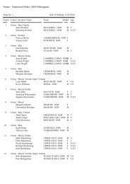
VRA novice pack 2002 - NSW Rogaining Association
VRA novice pack 2002 - NSW Rogaining Association
VRA novice pack 2002 - NSW Rogaining Association

Create successful ePaper yourself
Turn your PDF publications into a flip-book with our unique Google optimized e-Paper software.
Features of a compass<br />
Once you are sure about recognising features on the map, you<br />
can use a compass to help orient the map so the landscape<br />
features on the map are aligned in the direction of the real<br />
features. The compass is also used to help you travel along a<br />
line, or bearing, between two points.<br />
Figure 3 shows a diagram of a basic magnetic compass. It has a<br />
rectangular base plate of clear Perspex marked with the direction<br />
of travel arrow. Mounted at one end is the circular compass<br />
housing in which is the compass needle. The housing is oil filled<br />
to dampen the movement of the needle. It is transparent, has an<br />
orienting arrow inscribed into it under the needle and can be<br />
rotated within the base plate. North, South, East and West are<br />
marked around its perimeter along with 360° graduations.<br />
T <strong>Rogaining</strong> Tip<br />
If you are confused about<br />
distinguishing gullies<br />
from spurs have a look at<br />
where the creeks run,<br />
these are the gullies and<br />
valleys; the curves in<br />
between are the convex<br />
sides of hills called<br />
‘spurs’. Also, look for the<br />
summits (closed contour<br />
circles), these make it<br />
easy to identify the<br />
descending spurs<br />
Figure 2. Common contour patterns and features found on<br />
rogaining maps. This is a close-up of an actual rogaining map used<br />
in December 2001. The terminology used to identify features is<br />
explained on page 28 (Checkpoint Description Sheet Terminology).<br />
The scale of the map is a very important factor in reading the<br />
map correctly. A scale of 1:25000 (quite common on rogaining<br />
maps) means that 1 unit of distance on the map represents<br />
25,000 of the same units on the ground. For instance, on a<br />
1:25000 map, 4 cm is equivalent to 1 km on the ground (i.e. 4<br />
cm x 25,000 = 100,000 cm = 1000 m = 1 km). On a 1:50000<br />
scale map, 2 cm on the map represents 1 km on the ground.<br />
Most rogaining maps have a series of grid lines running topbottom<br />
and left-right. The distance between these lines is always<br />
1 km, which helps in estimating distances on the map. These<br />
grid lines also provide a reference for taking compass bearings.<br />
A piece of string, a ruler (edge of compass), or the edge of a piece<br />
of paper can be used to measure the distance between two features<br />
on a map and help calculate the actual distance on the ground.<br />
T <strong>Rogaining</strong> Tip<br />
Some maps have<br />
“magnetic north” lines<br />
marked on them, either<br />
instead of, or as well as,<br />
grid lines. These lines are<br />
used when taking compass<br />
bearings, and eliminate the<br />
need to account for<br />
magnetic declination.<br />
Grid north and magnetic<br />
north<br />
Compass<br />
housing<br />
Compass needle<br />
(always points to<br />
magnetic north)<br />
240<br />
210<br />
W<br />
S<br />
300<br />
150<br />
120<br />
330<br />
N<br />
E<br />
30<br />
60<br />
Base plate<br />
"Direction<br />
of travel"<br />
arrow<br />
"Orienting"<br />
arrow<br />
Figure 3.<br />
Features of<br />
a magnetic<br />
compass.<br />
Before using the compass it is important to understand the difference<br />
between Grid North and Magnetic North. Grid North is simply the<br />
direction of the north-south grid lines, where north is up the map.<br />
These grid lines are shown in Figures 2 and 4. Magnetic North is the<br />
direction the red end of a magnetic compass needle points. The grid<br />
lines on the map, however, are generally not aligned with Magnetic<br />
North.<br />
The angular difference between Grid North and Magnetic North<br />
on maps is called the grid magnetic angle. Often it will also be<br />
referred to as the magnetic declination, deviation or variation.<br />
This angle should be marked on all maps, and is typically about<br />
11 degrees to the East of Grid North in Victoria.<br />
Page 24 Which way’s north An introduction to <strong>Rogaining</strong> Victorian <strong>Rogaining</strong> <strong>Association</strong><br />
Victorian <strong>Rogaining</strong> <strong>Association</strong> Which way’s north An introduction to <strong>Rogaining</strong> Page 25