Project Status - Upper Midwest Environmental Sciences Center
Project Status - Upper Midwest Environmental Sciences Center
Project Status - Upper Midwest Environmental Sciences Center

You also want an ePaper? Increase the reach of your titles
YUMPU automatically turns print PDFs into web optimized ePapers that Google loves.
Geographic Information System (GIS) coverages were<br />
created for water surface elevations, land cover, floodplain<br />
elevations, land ownership, and levee locations. A water surface<br />
coverage for each of the 20 combinations of discharge<br />
and management plans was developed from the hydrologic<br />
model predictions. Twelve land cover classes were identified<br />
from color-infrared aerial photographs taken at a scale of<br />
1:15,000: open water, submergents, submergents-rooted floating<br />
aquatics, rooted floating aquatics-emergents, emergents,<br />
emergents-grasses-forbes, grasses-forbes, woody terrestrial,<br />
agriculture, urban-developed, and sand-mud. Two additional<br />
classes were created to help display results because of changes<br />
in discharge or management, dewatered aquatics and flooded<br />
terrestrial. Floodplain elevations were obtained from bathymetric<br />
surveys measured in 1993 and 1994, contour data from<br />
United States Geological Survey 1:24,000 quadrangle maps,<br />
and estimates of elevation from river gages when photographs<br />
of the water and land interface were obtained. A land ownership<br />
coverage was developed by digitizing maps obtained from<br />
the St. Louis District of the U.S. Army Corps of Engineers.<br />
Levee locations were obtained from a team studying the flood<br />
of 1993. The GIS was then used to integrate all coverages,<br />
predicting the habitats affected for each scenario or the acreage<br />
needed for flooding easements. Quantitative estimates of<br />
each affected habitat class were tabulated and color maps were<br />
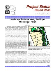
generated to illustrate spatial distribution of change. A black<br />
and white example of a map product is shown on the other<br />
side. Changes in aquatic areas ranged from a reduction of<br />
8,000 acres to an increase of 22,000 acres under various scenarios.<br />
The area of greatest change was in the impounded<br />
reach closest to the dam.<br />
The ATTZ, defined here as the amount of land area flooded<br />
between yearly average minimum and maximum water surface<br />
elevations, has been studied using the model. The ATTZ<br />
has changed considerably as a function of human activities on<br />
the floodplain. The areal extent of the ATTZ, both as it is now<br />
and as it would be if the dams and levees were not present,<br />
was calculated for three 2-mile wide bands representing the<br />
lower, middle, and upper reaches of the reservoir. In the lower<br />
reach of reservoir, the ATTZ is now only about 2/3 of its original<br />
size. In the other two reaches, the ATTZ is now only about<br />
1/3 of its original size.<br />
The model was also used to estimate the discharge representing<br />
ordinary high water and to predict additional lands<br />
that would be flooded as a result of alternative plans. One of<br />
the water level management options from the above study is<br />
presently being further investigated by the St. Louis District.<br />
It involves allowing a flexible control point (a specific location<br />
in the reservoir where a water level target is maintained).<br />
The major negative impact from this option would be the need<br />
for the St. Louis District to purchase additional land or flood<br />
easements. The model predicted that no lands would need to<br />
be purchased under any discharge for 13 miles immediately<br />
upriver of the dam. The maximum amount of land needed<br />
would be approximately 740 acres when water levels are maintained<br />
at their highest level at the discharge creating ordinary<br />
high water. This new plan would not have a detrimental effect<br />
on the 9-foot navigation channel and it would provide the<br />
management option of allowing for up to 4.3 feet of water<br />
level fluctuation for improvement of habitat for some organisms.<br />
To quantify the benefits that might be obtained from<br />
alternate water management strategies will require appropriate<br />
investigations.<br />
For further information, contact<br />
Joseph H. Wlosinski<br />
U.S. Geological Survey<br />
<strong>Environmental</strong> Managment Technical <strong>Center</strong><br />
575 Lester Avenue<br />
Onalaska, WI 54650<br />
Phone: 608/783-7550, extension 56<br />
E-mail: Joe_Wlosinski@nbs.gov<br />
James T. Rogala<br />
U.S. Geological Survey<br />
<strong>Environmental</strong> Managment Technical <strong>Center</strong><br />
575 Lester Avenue<br />
Onalaska, WI 54650<br />
Phone: 608/783-7550, extension 60<br />
E-mail: Jim_Rogala@nbs.gov<br />
<strong>Project</strong> <strong>Status</strong> Reports (PSRs) are internal Long Term Resource Monitoring Program documents whose purpose is to provide information on Program activities. Because PSRs are<br />
not subject to peer review, they may not be cited. Use of trade names does not imply U.S. Government endorsement of commercial products.<br />
October 1996 PSR 96-03<br />
United States Department of the Interior<br />
U.S. Geological Survey<br />
<strong>Environmental</strong> Management Technical <strong>Center</strong><br />
575 Lester Avenue<br />
Onalaska, WI 54650-8552<br />
608/783-7550<br />
BULK RATE<br />
Postage and Fees Paid<br />
U.S. Geological Survey<br />
Permit No. G-790