Township of Langley Groundwater Management: Case Study
Township of Langley Groundwater Management: Case Study
Township of Langley Groundwater Management: Case Study

You also want an ePaper? Increase the reach of your titles
YUMPU automatically turns print PDFs into web optimized ePapers that Google loves.
Regional District (GVRD) surface water (60%). The <strong>Township</strong> prefers to use its own<br />
available groundwater, as it is significantly cheaper than purchasing surface water from<br />
the GVRD. The <strong>Township</strong> <strong>of</strong> <strong>Langley</strong> operates 18 municipal wells, and private wells<br />
number at least 5,000 (<strong>Township</strong> <strong>of</strong> <strong>Langley</strong> 2007). The actual number <strong>of</strong> private wells is<br />
not known, as permits are not required when wells are drilled. In the absence <strong>of</strong><br />
provincial regulation <strong>of</strong> groundwater taking, it is unknown just how much groundwater is<br />
extracted for domestic, agricultural and commercial purposes.<br />
Approximately three-quarters <strong>of</strong> the <strong>Township</strong>’s land is in the Agricultural Land Reserve,<br />
and these rural areas are outside <strong>of</strong> the municipal system. <strong>Groundwater</strong> extracted here for<br />
agricultural purposes is significant, and as with other uses, has the potential for depleting<br />
the groundwater resource.<br />
<strong>Groundwater</strong> quantity a key issue<br />
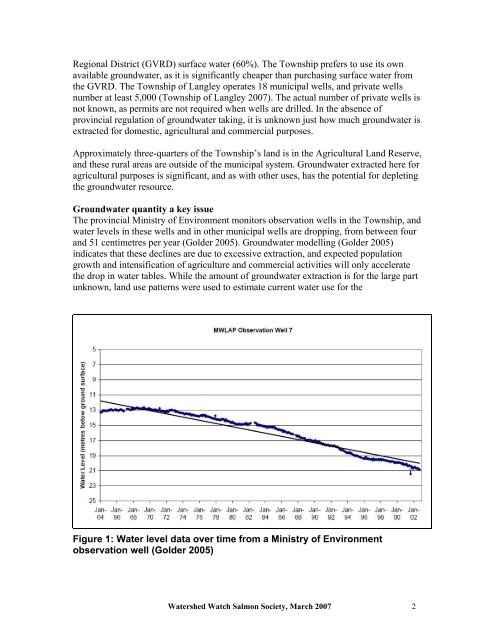
The provincial Ministry <strong>of</strong> Environment monitors observation wells in the <strong>Township</strong>, and<br />
water levels in these wells and in other municipal wells are dropping, from between four<br />
and 51 centimetres per year (Golder 2005). <strong>Groundwater</strong> modelling (Golder 2005)<br />
indicates that these declines are due to excessive extraction, and expected population<br />
growth and intensification <strong>of</strong> agriculture and commercial activities will only accelerate<br />
the drop in water tables. While the amount <strong>of</strong> groundwater extraction is for the large part<br />
unknown, land use patterns were used to estimate current water use for the<br />
Figure 1: Water level data over time from a Ministry <strong>of</strong> Environment<br />
observation well (Golder 2005)<br />
Watershed Watch Salmon Society, March 2007 2