Karst geohazards in the UK: the use of digital data for hazard ... - Ispra
Karst geohazards in the UK: the use of digital data for hazard ... - Ispra
Karst geohazards in the UK: the use of digital data for hazard ... - Ispra

You also want an ePaper? Increase the reach of your titles
YUMPU automatically turns print PDFs into web optimized ePapers that Google loves.
<strong>Karst</strong> <strong>geo<strong>hazard</strong>s</strong> <strong>in</strong> <strong>the</strong> <strong>UK</strong>: <strong>the</strong> <strong>use</strong> <strong>of</strong> <strong>digital</strong> <strong>data</strong> <strong>for</strong><br />
<strong>hazard</strong> management<br />
A.R. Farrant & A.H. Cooper<br />
British Geological Survey, Keyworth, Nott<strong>in</strong>gham NG12 5GG, <strong>UK</strong> (e-mail: arf@bgs.ac.uk)<br />
An essential prerequisite <strong>for</strong> any eng<strong>in</strong>eer<strong>in</strong>g or<br />
hydrogeological <strong>in</strong>vestigation <strong>of</strong> soluble rocks<br />
is <strong>the</strong> identification and description <strong>of</strong> <strong>the</strong>ir<br />
characteristic, observable and detectable dissolution<br />
features, such as stream s<strong>in</strong>ks, spr<strong>in</strong>gs, s<strong>in</strong>kholes<br />
and caves. The British Geological Survey (BGS) is<br />
creat<strong>in</strong>g a National <strong>Karst</strong> Database (NKD) that records<br />
such features across <strong>the</strong> country. The <strong>data</strong>base currently<br />
covers much <strong>of</strong> <strong>the</strong> region underla<strong>in</strong> by Carboniferous<br />
Limestone, <strong>the</strong> Chalk, and particularly <strong>the</strong> Permo-Triassic<br />
gypsum and halite where rapid, active dissolution has<br />
ca<strong>use</strong>d significant subsidence and build<strong>in</strong>g damage. In<br />
addition to, and separate from, <strong>the</strong> identification <strong>of</strong><br />
specific karst features, <strong>the</strong> BGS has created a National<br />
<strong>Karst</strong> Geo<strong>hazard</strong> geographical <strong>in</strong><strong>for</strong>mation system (GIS).<br />
This has been created to identify areas that may potentially<br />
conta<strong>in</strong> karst <strong>geo<strong>hazard</strong>s</strong>. Initially, all <strong>the</strong> soluble<br />
rock units identified from <strong>the</strong> BGS 1:50 000 scale <strong>digital</strong><br />
geological map are extracted. Each soluble unit has been<br />
given an objective score, <strong>in</strong>terpreted, as based on factors<br />
<strong>in</strong>clud<strong>in</strong>g lithology, topography, geomorphological position<br />
and characteristic superficial cover deposits. This<br />
national zonation <strong>of</strong> <strong>the</strong>se soluble rocks can <strong>the</strong>n be <strong>use</strong>d<br />
to identify areas where <strong>the</strong> occurrence potential <strong>for</strong><br />
karstic features is significant, and where dissolution features<br />
might affect <strong>the</strong> stability <strong>of</strong> build<strong>in</strong>gs and <strong>in</strong>frastructure,<br />
or where karstic groundwater flow might occur. Both<br />
<strong>data</strong>sets are seen as <strong>in</strong>valuable scientific tools that have<br />
already been widely <strong>use</strong>d to support site <strong>in</strong>vestigation,<br />
groundwater <strong>in</strong>vestigations, plann<strong>in</strong>g, construction and<br />
<strong>the</strong> <strong>in</strong>surance underwrit<strong>in</strong>g bus<strong>in</strong>esses.<br />
travel, commonly some distance from <strong>the</strong>ir source, thus<br />
pos<strong>in</strong>g ano<strong>the</strong>r <strong>for</strong>m <strong>of</strong> unanticipated environmental<br />
risk.<br />
Databases and maps <strong>of</strong> karst <strong>hazard</strong>s are important<br />
<strong>for</strong> understand<strong>in</strong>g <strong>the</strong> severity <strong>of</strong> <strong>the</strong> problem, and <strong>the</strong>y<br />
constitute <strong>use</strong>ful tools <strong>for</strong> public governance choices <strong>in</strong><br />
<strong>hazard</strong> avoidance that have relevance to plann<strong>in</strong>g, eng<strong>in</strong>eer<strong>in</strong>g,<br />
development and <strong>the</strong> <strong>in</strong>surance underwrit<strong>in</strong>g<br />
<strong>in</strong>dustry. Developers, planners and local government<br />
can be expected to operate effectively only if <strong>the</strong>y<br />
have advance scientific warn<strong>in</strong>g about <strong>the</strong> <strong>hazard</strong>s that<br />
might be present and have access to relevant geological<br />
<strong>in</strong><strong>for</strong>mation.<br />
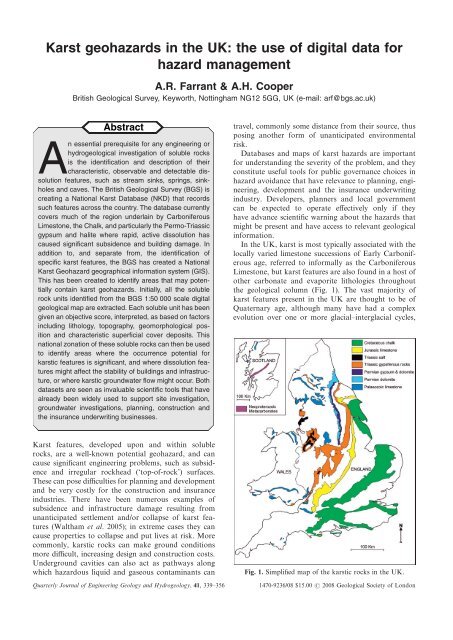
In <strong>the</strong> <strong>UK</strong>, karst is most typically associated with <strong>the</strong><br />
locally varied limestone successions <strong>of</strong> Early Carboniferous<br />
age, referred to <strong>in</strong><strong>for</strong>mally as <strong>the</strong> Carboniferous<br />
Limestone, but karst features are also found <strong>in</strong> a host <strong>of</strong><br />
o<strong>the</strong>r carbonate and evaporite lithologies throughout<br />
<strong>the</strong> geological column (Fig. 1). The vast majority <strong>of</strong><br />
karst features present <strong>in</strong> <strong>the</strong> <strong>UK</strong> are thought to be <strong>of</strong><br />
Quaternary age, although many have had a complex<br />
evolution over one or more glacial–<strong>in</strong>terglacial cycles,<br />
<strong>Karst</strong> features, developed upon and with<strong>in</strong> soluble<br />
rocks, are a well-known potential geo<strong>hazard</strong>, and can<br />
ca<strong>use</strong> significant eng<strong>in</strong>eer<strong>in</strong>g problems, such as subsidence<br />
and irregular rockhead (‘top-<strong>of</strong>-rock’) surfaces.<br />
These can pose difficulties <strong>for</strong> plann<strong>in</strong>g and development<br />
and be very costly <strong>for</strong> <strong>the</strong> construction and <strong>in</strong>surance<br />
<strong>in</strong>dustries. There have been numerous examples <strong>of</strong><br />
subsidence and <strong>in</strong>frastructure damage result<strong>in</strong>g from<br />
unanticipated settlement and/or collapse <strong>of</strong> karst features<br />
(Waltham et al. 2005); <strong>in</strong> extreme cases <strong>the</strong>y can<br />
ca<strong>use</strong> properties to collapse and put lives at risk. More<br />
commonly, karstic rocks can make ground conditions<br />
more difficult, <strong>in</strong>creas<strong>in</strong>g design and construction costs.<br />
Underground cavities can also act as pathways along<br />
which <strong>hazard</strong>ous liquid and gaseous contam<strong>in</strong>ants can<br />
Quarterly Journal <strong>of</strong> Eng<strong>in</strong>eer<strong>in</strong>g Geology and Hydrogeology, 41, 339–356<br />
Fig. 1. Simplified map <strong>of</strong> <strong>the</strong> karstic rocks <strong>in</strong> <strong>the</strong> <strong>UK</strong>.<br />
1470-9236/08 $15.00 2008 Geological Society <strong>of</strong> London
340<br />
A.R. FARRANT & A.H. COOPER<br />
and some caves are potentially much older. Triassic<br />
palaeokarst is present <strong>in</strong> some areas (Simms 1990), but is<br />
generally <strong>of</strong> local extent. An overview <strong>of</strong> <strong>the</strong> <strong>UK</strong> karst<br />
has been given by Waltham et al. (1997).<br />
Palaeozoic and Neoproterozoic limestones<br />
The oldest rocks that exhibit karstic features <strong>in</strong> <strong>the</strong> <strong>UK</strong><br />
are <strong>the</strong> th<strong>in</strong> metacarbonate beds preserved with<strong>in</strong> parts<br />
<strong>of</strong> <strong>the</strong> Dalradian Supergroup <strong>of</strong> <strong>the</strong> Scottish Highlands.<br />
The features here are perhaps analogous to <strong>the</strong><br />
Scand<strong>in</strong>avian stripe karst (Lauritzen 2001). Numerous<br />
small caves, s<strong>in</strong>kholes, stream s<strong>in</strong>ks and spr<strong>in</strong>gs have<br />
been recorded <strong>in</strong> <strong>the</strong> App<strong>in</strong> and Schiehallion regions <strong>of</strong><br />
<strong>the</strong> Scottish Highlands (Oldham 1975). However, many<br />
<strong>of</strong> <strong>the</strong>se are <strong>in</strong> remote upland areas and generally pose<br />
little risk to <strong>in</strong>frastructure. Elsewhere <strong>in</strong> NW Scotland,<br />
Cambrian to Ordovician limestones and dolomites<br />
belong<strong>in</strong>g to <strong>the</strong> Durness Group crop out <strong>in</strong> a long<br />
narrow belt along <strong>the</strong> l<strong>in</strong>e <strong>of</strong> <strong>the</strong> Mo<strong>in</strong>e Thrust and on<br />
<strong>the</strong> Isle <strong>of</strong> Skye. Several extensive well-developed karstic<br />
cave systems, <strong>for</strong> example <strong>the</strong> Allt nan Uamh system,<br />
and those <strong>in</strong> <strong>the</strong> Traligill valley have been described (e.g.<br />
Lawson 1988; Waltham et al. 1997), although aga<strong>in</strong><br />
many <strong>of</strong> <strong>the</strong>se are <strong>in</strong> remote upland areas.<br />
Far<strong>the</strong>r south, m<strong>in</strong>or dissolution features and<br />
enlarged fractures have been identified from limestones<br />
<strong>of</strong> Wenlock (Silurian) age <strong>in</strong> <strong>the</strong> West Midlands and <strong>the</strong><br />
Welsh Borders, but no significant cave systems are yet<br />
known. Limestones <strong>of</strong> Devonian age crop out <strong>in</strong> parts <strong>of</strong><br />
Devon, particularly around Plymouth, Buckfastleigh<br />
and Torbay. Several well-developed cave systems are<br />
known <strong>in</strong> <strong>the</strong>se areas (Oldham et al. 1986), along with<br />
stream s<strong>in</strong>ks, ‘los<strong>in</strong>g’ streams, karstic spr<strong>in</strong>gs, s<strong>in</strong>kholes<br />
(dol<strong>in</strong>es) and areas <strong>of</strong> irregular rockhead. Infrastructure<br />
problems with karstic cavities and buried s<strong>in</strong>kholes have<br />
been reported <strong>in</strong> <strong>the</strong> Plymouth area.<br />
It is <strong>the</strong> Carboniferous Limestone that hosts <strong>the</strong><br />
best-developed karst landscapes and <strong>the</strong> longest and<br />
most-developed cave systems <strong>in</strong> <strong>the</strong> country. It occurs<br />
widely throughout western and nor<strong>the</strong>rn England and <strong>in</strong><br />
Wales, and karst features are present on and with<strong>in</strong> <strong>the</strong><br />
majority <strong>of</strong> <strong>the</strong> outcrop (Waltham et al. 1997). Particularly<br />
well-developed karst occurs <strong>in</strong> <strong>the</strong> Mendip Hills,<br />
around <strong>the</strong> nor<strong>the</strong>rn crop <strong>of</strong> <strong>the</strong> South Wales coalfield<br />
(Ford 1989), <strong>in</strong> <strong>the</strong> Derbyshire Peak District and <strong>in</strong> <strong>the</strong><br />
Yorkshire Dales and adjacent areas, runn<strong>in</strong>g up <strong>in</strong>to <strong>the</strong><br />
nor<strong>the</strong>rn Penn<strong>in</strong>es. Less well-known karst areas <strong>in</strong>clude<br />
<strong>the</strong> Forest <strong>of</strong> Dean, <strong>the</strong> sou<strong>the</strong>rn crop <strong>of</strong> <strong>the</strong> South<br />
Wales coalfield from Glamorgan through <strong>the</strong> Gower to<br />
Pembrokeshire, <strong>in</strong> North Wales around <strong>the</strong> Vale <strong>of</strong><br />
Clwyd, and around <strong>the</strong> fr<strong>in</strong>ges <strong>of</strong> <strong>the</strong> Lake District. In<br />
all <strong>the</strong>se areas, well-developed karstic dra<strong>in</strong>age systems,<br />
s<strong>in</strong>kholes and extensive cave systems are common,<br />
many <strong>of</strong> which are associated with significant allogenic<br />
dra<strong>in</strong>age catchments as a source <strong>of</strong> <strong>the</strong> dissolution<br />
waters.<br />
Fig. 2. A s<strong>in</strong>khole <strong>for</strong>med after severe flood<strong>in</strong>g <strong>in</strong> 1968 near<br />
Cheddar, Somerset [ST 4765 5620]. Superficial loessic cover<br />
sands have slumped <strong>in</strong>to <strong>the</strong> underly<strong>in</strong>g GB Cavern. An<br />
attempt was made to fill <strong>in</strong> <strong>the</strong> hole with old cars, which can<br />
still be seen <strong>in</strong> <strong>the</strong> cave below. Photo A. Farrant, copyright<br />
NERC.<br />
The major challenges associated with <strong>the</strong>se karst areas<br />
are water supply protection (both quality and quantity),<br />
geological conservation and practical eng<strong>in</strong>eer<strong>in</strong>g problems<br />
related to mitigat<strong>in</strong>g and accommodat<strong>in</strong>g <strong>the</strong><br />
result<strong>in</strong>g subsurface voids. Subsidence associated with<br />
s<strong>in</strong>khole <strong>for</strong>mation is commonly encountered <strong>in</strong> remote<br />
and rural areas with little impact on property and<br />
<strong>in</strong>frastructure, but damage to ho<strong>use</strong>s, tracks and roads is<br />
locally a problem. Commonly <strong>of</strong> greater significance,<br />
many <strong>of</strong> <strong>the</strong>se subsidence hollows are sites <strong>for</strong> illegal<br />
tipp<strong>in</strong>g <strong>of</strong> farm and o<strong>the</strong>r ref<strong>use</strong> or waste, which can<br />
ca<strong>use</strong> rapid contam<strong>in</strong>ation <strong>of</strong> <strong>the</strong> groundwater and local<br />
dr<strong>in</strong>k<strong>in</strong>g supplies (Fig. 2).<br />
Permian dolomites and limestones<br />
The Permian carbonates <strong>in</strong> <strong>the</strong> <strong>UK</strong> are dom<strong>in</strong>ated by<br />
magnesium-rich limestones and dolomites. The solubility<br />
<strong>of</strong> <strong>the</strong>se rocks is characteristically lower than that<br />
<strong>of</strong> <strong>the</strong> pure limestones, and so karstic features are less<br />
well developed <strong>in</strong> this terra<strong>in</strong>. However, <strong>the</strong> dolomites<br />
are closely associated with bodies <strong>of</strong> gypsum, which<br />
typically are heavily karstified. Numerous small (generally<br />
less than a few tens <strong>of</strong> metres <strong>in</strong> length) cave systems<br />
are present along <strong>the</strong> outcrop <strong>of</strong> <strong>the</strong> magnesian limestones<br />
from near Mansfield <strong>in</strong> <strong>the</strong> south to Sunderland<br />
<strong>in</strong> <strong>the</strong> north. Some s<strong>in</strong>k<strong>in</strong>g streams are present as are<br />
numerous spr<strong>in</strong>gs, but very few s<strong>in</strong>kholes are to be<br />
found (possibly beca<strong>use</strong> <strong>of</strong> <strong>in</strong>fill<strong>in</strong>g by agricultural practices<br />
over <strong>the</strong> centuries) and <strong>the</strong> rock is generally not<br />
problematical <strong>for</strong> eng<strong>in</strong>eer<strong>in</strong>g purposes. However,<br />
numerous open jo<strong>in</strong>ts, <strong>in</strong>cipient conduit systems on bedd<strong>in</strong>g<br />
planes, palaeokarst, and sediment-<strong>in</strong>filled fissures<br />
can be identified <strong>in</strong> road cutt<strong>in</strong>gs and quarries. Hydrogeologically,<br />
<strong>the</strong>se rocks support a m<strong>in</strong>or to moderatesized<br />
aquifer, potentially susceptible to resource damage<br />
from pollution and land development, especially from<br />
landfill contam<strong>in</strong>ation from <strong>for</strong>mer <strong>in</strong>filled quarries.<br />
In <strong>the</strong> Mendips, South Wales and parts <strong>of</strong><br />
Devon, limestone-rich Permo-Triassic conglomerates
KARST GEOHAZARDS IN THE <strong>UK</strong> 341<br />
(predom<strong>in</strong>antly, but not exclusively derived from<br />
Carboniferous limestone uplands) can be expected to<br />
host karstic cave systems, perhaps <strong>the</strong> most famous<br />
example be<strong>in</strong>g Wookey Hole <strong>in</strong> Somerset.<br />
Jurassic limestones<br />
Jurassic limestones extend across much <strong>of</strong> central,<br />
sou<strong>the</strong>rn and eastern England <strong>in</strong> a belt from Dorset to<br />
North Yorkshire, and <strong>in</strong> parts <strong>of</strong> western Scotland.<br />
Although <strong>the</strong> karst <strong>in</strong> <strong>the</strong>se rocks is not as well developed<br />
as <strong>in</strong> <strong>the</strong> more massive Palaeozoic limestone<br />
terra<strong>in</strong>, karst features do occur, particularly <strong>in</strong> some <strong>of</strong><br />
<strong>the</strong> Portlandian and Purbeck limestones <strong>in</strong> Dorset and<br />
Wiltshire, <strong>in</strong> <strong>the</strong> Cornbrash, and <strong>in</strong> <strong>the</strong> Corallian limestones<br />
around Ox<strong>for</strong>d and on <strong>the</strong> sou<strong>the</strong>rn flank <strong>of</strong> <strong>the</strong><br />
North York Moors, where a cave system >1 km long<br />
has recently been discovered. <strong>Karst</strong> is also well developed<br />
<strong>in</strong> <strong>the</strong> L<strong>in</strong>colnshire Limestone south <strong>of</strong> Grantham<br />
(H<strong>in</strong>dley 1965). Here, water supply protection is <strong>the</strong><br />
ma<strong>in</strong> issue, although localized subsidence and areas <strong>of</strong><br />
irregular rock-head are to be expected.<br />
Cretaceous Chalk<br />
The Chalk is <strong>the</strong> most widespread carbonate rock <strong>in</strong> <strong>the</strong><br />
country and <strong>of</strong> immense importance <strong>for</strong> its water supply<br />
resource. It <strong>for</strong>ms <strong>the</strong> <strong>UK</strong>’s most important aquifer.<br />
<strong>Karst</strong> features occur <strong>in</strong> many parts <strong>of</strong> <strong>the</strong> Chalk outcrop,<br />
particularly along <strong>the</strong> marg<strong>in</strong> <strong>of</strong> <strong>the</strong> Palaeogene<br />
cover (Farrant 2001). In <strong>the</strong>se areas, <strong>the</strong> development <strong>of</strong><br />
dissolutionally enlarged fissures and conduits can potentially<br />
ca<strong>use</strong> problems <strong>for</strong> groundwater supply by creat<strong>in</strong>g<br />
rapid-transport contam<strong>in</strong>ant pathways though <strong>the</strong><br />
aquifer (Maurice et al. 2006). This is particularly important<br />
as parts <strong>of</strong> <strong>the</strong> Chalk outcrop underlie major transport<br />
corridors and urban areas; both <strong>of</strong> which are<br />
notorious suppliers <strong>of</strong> surface-ga<strong>the</strong>red contam<strong>in</strong>ants<br />
via run<strong>of</strong>f. Chalk dissolution also generates subsidence<br />
<strong>hazard</strong>s and presents difficult ground conditions associated<br />
with <strong>the</strong> development <strong>of</strong> clay-filled pipes and fissures.<br />
These problems <strong>in</strong>clude irregular rockhead,<br />
localized subsidence, <strong>in</strong>creased mass compressibility and<br />
dim<strong>in</strong>ished rock mass quality. Well-developed karstic<br />
groundwater flow systems occur <strong>in</strong> Dorset, near Salisbury,<br />
around Newbury and Hunger<strong>for</strong>d, and <strong>in</strong> many<br />
parts <strong>of</strong> <strong>the</strong> Chilterns, particularly along <strong>the</strong> Palaeogene<br />
marg<strong>in</strong> between Beaconsfield and Hert<strong>for</strong>d (Waltham<br />
et al. 1997).<br />
Triassic and Permian salt<br />
In <strong>the</strong> <strong>UK</strong>, halite (rock salt) occurs ma<strong>in</strong>ly with<strong>in</strong> <strong>the</strong><br />
Triassic strata <strong>of</strong> <strong>the</strong> Cheshire Bas<strong>in</strong>, and to a lesser<br />
extent <strong>in</strong> parts <strong>of</strong> Lancashire, Worcestershire and<br />
Staf<strong>for</strong>dshire. It is also present <strong>in</strong> <strong>the</strong> Permian rocks <strong>of</strong><br />
NE England and Nor<strong>the</strong>rn Ireland (Notholt & Highley<br />
1973). Where <strong>the</strong> saliferous Triassic rocks come to<br />
outcrop, most <strong>of</strong> <strong>the</strong> halite has dissolved and <strong>the</strong> overly<strong>in</strong>g<br />
and <strong>in</strong>terbedded strata can be expected to have<br />
collapsed or foundered, produc<strong>in</strong>g a buried salt karst<br />
<strong>hazard</strong>. This represents a more difficult site classification<br />
problem than perhaps elsewhere. These areas commonly<br />
have sal<strong>in</strong>e spr<strong>in</strong>gs, <strong>in</strong>dicative <strong>of</strong> cont<strong>in</strong>u<strong>in</strong>g salt dissolution<br />
and <strong>the</strong> active nature <strong>of</strong> <strong>the</strong> karst processes. The<br />
salt deposits were exploited us<strong>in</strong>g <strong>the</strong>se spr<strong>in</strong>gs from<br />
be<strong>for</strong>e early Roman times to Victorian times, when more<br />
<strong>in</strong>tense and organized br<strong>in</strong>e and m<strong>in</strong>ed salt extraction<br />
was undertaken. Halite dissolves rapidly and subsidence,<br />
both natural and m<strong>in</strong><strong>in</strong>g-<strong>in</strong>duced, has affected <strong>the</strong> ma<strong>in</strong><br />
Triassic salt fields <strong>in</strong>clud<strong>in</strong>g Cheshire, Staf<strong>for</strong>dshire<br />
(Staf<strong>for</strong>d), Worcestershire (Droitwich), coastal<br />
Lancashire (Preesall) and parts <strong>of</strong> Nor<strong>the</strong>rn Ireland.<br />
Much <strong>of</strong> <strong>the</strong> salt m<strong>in</strong><strong>in</strong>g has been by shallow br<strong>in</strong>e<br />
extraction, <strong>the</strong> results <strong>of</strong> which also mimic <strong>the</strong> effects <strong>of</strong><br />
natural karstification <strong>of</strong> <strong>the</strong> salt deposits.<br />
Permian salt is present at depth beneath coastal<br />
Yorkshire and Teesside. Here <strong>the</strong> salt deposits and <strong>the</strong><br />
karstification processes are much deeper than <strong>in</strong> <strong>the</strong><br />
Triassic salt. The salt deposits are bounded up-dip by a<br />
dissolution front and collapse monocl<strong>in</strong>e (Cooper 2002).<br />
The depth <strong>of</strong> <strong>the</strong> salt dissolution means that very few<br />
karstic features are present, ei<strong>the</strong>r as <strong>for</strong>med at or as<br />
migrated upward to <strong>the</strong> present ground surface,<br />
although some salt m<strong>in</strong><strong>in</strong>g (br<strong>in</strong><strong>in</strong>g) subsidence has<br />
occurred.<br />
Triassic and Permian gypsum<br />
Compared with <strong>the</strong> British limestone karst, gypsum<br />
karst occurs only <strong>in</strong> relatively small areas. It is present<br />
ma<strong>in</strong>ly <strong>in</strong> a belt 3 km wide and about 100 km long <strong>in</strong> <strong>the</strong><br />
Permian rocks <strong>of</strong> eastern and nor<strong>the</strong>astern England<br />
(Cooper 1989). Significant thicknesses <strong>of</strong> gypsum also<br />
occur along <strong>the</strong> eastern flank <strong>of</strong> <strong>the</strong> Vale <strong>of</strong> Eden (Ryder<br />
& Cooper 1993). It also locally occurs <strong>in</strong> <strong>the</strong> Triassic<br />
strata (Cooper & Saunders 1999), but <strong>the</strong> effects <strong>of</strong><br />
karstification are much less severe than <strong>in</strong> <strong>the</strong> Permian<br />
rocks. The difference is ma<strong>in</strong>ly ca<strong>use</strong>d by <strong>the</strong> thickness<br />
<strong>of</strong> gypsum <strong>in</strong> <strong>the</strong> Permian sequence and <strong>the</strong> fact that<br />
it has <strong>in</strong>terbedded dolomite aquifers. In contrast, <strong>the</strong><br />
Triassic gypsum is present ma<strong>in</strong>ly <strong>in</strong> weakly permeable<br />
mudstone sequences. The gypsum karst has <strong>for</strong>med<br />
phreatic cave systems dissolved by water flow below <strong>the</strong><br />
piezometric surface to depths <strong>of</strong> up to 70–80 m. The<br />
rapid solubility rate <strong>of</strong> <strong>the</strong> gypsum (Klimchouk et al.<br />
1997) means that <strong>the</strong> karst is evolv<strong>in</strong>g on a human<br />
time scale. Active subsidence occurs <strong>in</strong> many places,<br />
especially around <strong>the</strong> town <strong>of</strong> Ripon (Cooper 1986,<br />
1989, 1998) and to a lesser extent <strong>in</strong> <strong>the</strong> eastern part <strong>of</strong><br />
urban Darl<strong>in</strong>gton (Lamont-Black et al. 2002); it also<br />
occurs <strong>in</strong> several o<strong>the</strong>r locations along <strong>the</strong> outcrop<br />
<strong>for</strong>m<strong>in</strong>g a belt about 100 km long and 3–5 km wide. The
342<br />
A.R. FARRANT & A.H. COOPER<br />
active nature <strong>of</strong> <strong>the</strong> dissolution and <strong>the</strong>se cont<strong>in</strong>u<strong>in</strong>g<br />
subsidence features ca<strong>use</strong> difficult ground conditions <strong>for</strong><br />
plann<strong>in</strong>g and development (Cooper & Saunders 1999;<br />
Paukštys et al. 1999; Cooper & Saunders 2002). Gypsum<br />
palaeokarst features also occur, especially along <strong>the</strong><br />
coast <strong>of</strong> NE England and <strong>in</strong> <strong>the</strong> Firth <strong>of</strong> Forth <strong>of</strong>f<br />
eastern Scotland (Cooper 1997).<br />
The National <strong>Karst</strong> Database (NKD)<br />
Geologists and eng<strong>in</strong>eers have recognized <strong>for</strong> some time<br />
that <strong>the</strong> availability <strong>of</strong> geoscience basel<strong>in</strong>e <strong>data</strong> is essential<br />
<strong>for</strong> <strong>the</strong> public safety and eng<strong>in</strong>eer<strong>in</strong>g assessment <strong>of</strong><br />
geological <strong>hazard</strong>s. Understand<strong>in</strong>g <strong>the</strong> severity <strong>of</strong> <strong>the</strong><br />
problem is a prerequisite <strong>for</strong> <strong>hazard</strong> avoidance. Land<br />
developers, planners and local government can plan<br />
accord<strong>in</strong>gly and responsibly if <strong>the</strong>y can cite advance<br />
scientific–technical warn<strong>in</strong>g about <strong>the</strong> <strong>hazard</strong>s that<br />
might be present and have access to relevant geological<br />
<strong>in</strong><strong>for</strong>mation. General guidance <strong>for</strong> <strong>the</strong> development <strong>of</strong><br />
unstable land is written <strong>in</strong>to British Government plann<strong>in</strong>g<br />
policy <strong>in</strong> <strong>the</strong> Plann<strong>in</strong>g Policy Guidance Note 14:<br />
Development on Unstable Land (Department <strong>of</strong> <strong>the</strong><br />
Environment 1990), and <strong>the</strong> supplementary Annex 2<br />
(Department <strong>of</strong> Transport, Local Government & <strong>the</strong><br />
Regions 2002).<br />
When this policy was implemented, rudimentary basel<strong>in</strong>e<br />
<strong>data</strong> were collected <strong>in</strong> an <strong>in</strong>itial <strong>data</strong>base <strong>of</strong> natural<br />
cavities commissioned by <strong>the</strong> Department <strong>of</strong> <strong>the</strong><br />
Environment and produced by a private geological<br />
consultancy, Applied Geology Ltd (1993). This is now<br />
held, and ma<strong>in</strong>ta<strong>in</strong>ed as a legacy <strong>data</strong>set, by <strong>the</strong> British<br />
Geological Survey (BGS), and is <strong>of</strong>fered as a technical<br />
service by Peter Brett Associates, a private geological<br />
consultancy. This study demonstrated <strong>the</strong> national<br />
character and distribution <strong>of</strong> karst and o<strong>the</strong>r natural<br />
cavities, based on documentary evidence from a wide<br />
variety <strong>of</strong> sources. However, <strong>in</strong> many cases <strong>the</strong> spatial<br />
record<strong>in</strong>g was not very accurate, commonly only to <strong>the</strong><br />
nearest kilometre, and <strong>in</strong> many cases was based upon<br />
only <strong>the</strong> barest m<strong>in</strong>imum <strong>of</strong> support<strong>in</strong>g <strong>data</strong>. Fur<strong>the</strong>rmore,<br />
<strong>the</strong> <strong>data</strong>base was over-complex and many <strong>of</strong> <strong>the</strong><br />
<strong>data</strong>base fields rema<strong>in</strong>ed empty. At <strong>the</strong> time <strong>the</strong> <strong>data</strong>base<br />
fields were recognized as essential to <strong>the</strong> best<br />
understand<strong>in</strong>g <strong>of</strong> mitigative prediction, and <strong>the</strong> decision<br />
was made to present <strong>the</strong> categorical need <strong>for</strong> such <strong>data</strong>,<br />
even if <strong>the</strong> bare m<strong>in</strong>imum was not <strong>the</strong>n available. S<strong>in</strong>ce<br />
that time, recent mapp<strong>in</strong>g, particularly <strong>in</strong> Chalk terra<strong>in</strong>s,<br />
has shown that <strong>the</strong> previously available <strong>data</strong> significantly<br />
under-represents <strong>the</strong> actual density <strong>of</strong> karst features<br />
now generally known to be present. Moreover,<br />
many more karst features have been identified s<strong>in</strong>ce<br />
1993, both by more recent geological mapp<strong>in</strong>g, but also<br />
through <strong>the</strong> advent <strong>of</strong> more sophisticated remote sens<strong>in</strong>g<br />
techniques such as LiDAR (light detection and rang<strong>in</strong>g).<br />
Cavers have also opened up many newly discovered cave<br />
Fig. 3. Field geologist’s field slip [OLL 131 NW (E)], compiled<br />
by F. B. A. Welch, surveyed <strong>in</strong> 1941, describ<strong>in</strong>g a stream s<strong>in</strong>k<br />
<strong>in</strong> <strong>the</strong> Upper L<strong>in</strong>colnshire Limestone Member (Jurassic), near<br />
Burton-le-Coggles [SK 9683 2595], and its response to a flood.<br />
The railway l<strong>in</strong>e is <strong>the</strong> East Coast Ma<strong>in</strong> L<strong>in</strong>e.<br />
systems, <strong>in</strong>clud<strong>in</strong>g one <strong>of</strong> Brita<strong>in</strong>’s longest cave systems,<br />
Og<strong>of</strong> Draenen near Blaenavon (Farrant 2004), now<br />
known to be over 70 km <strong>in</strong> length, and also have<br />
discovered <strong>the</strong> country’s deepest natural vertical cavern,<br />
<strong>the</strong> 145 m deep Titan shaft <strong>in</strong> Derbyshire’s Peak Cavern.<br />
Documented speleological studies <strong>of</strong> cave systems can<br />
provide <strong>use</strong>ful <strong>in</strong>sights <strong>in</strong>to <strong>the</strong> potential <strong>for</strong> karst <strong>geo<strong>hazard</strong>s</strong><br />
to develop <strong>in</strong> <strong>the</strong> surround<strong>in</strong>g area (Klimchouk<br />
& Lowe 2002).<br />
Much <strong>of</strong> <strong>the</strong> <strong>in</strong><strong>for</strong>mation <strong>in</strong> <strong>the</strong> relict Applied<br />
Geology <strong>data</strong>set was extracted directly from published<br />
BGS maps, memoirs and reports. However, additional<br />
<strong>in</strong><strong>for</strong>mation now is available <strong>for</strong> systematic <strong>in</strong>tegration,<br />
as represented by historical unpublished geological field<br />
slips and notebooks held <strong>in</strong> <strong>the</strong> National Geological<br />
Data Centre <strong>in</strong> Keyworth. <strong>Karst</strong> features have been<br />
recorded rout<strong>in</strong>ely by field geologists on <strong>the</strong>ir field slips<br />
s<strong>in</strong>ce <strong>the</strong> Survey’s <strong>in</strong>ception <strong>in</strong> 1835. However, <strong>the</strong>y have<br />
only rarely been depicted on published map and reports,<br />
and <strong>the</strong> <strong>data</strong> conta<strong>in</strong>ed on <strong>the</strong>m can be difficult to access.<br />
In 2000, as part <strong>of</strong> a drive to make its <strong>data</strong>sets more<br />
accessible <strong>for</strong> <strong>the</strong> common good, <strong>the</strong> BGS embarked on<br />
construct<strong>in</strong>g a more comprehensive geographic <strong>in</strong><strong>for</strong>mation<br />
system (GIS) and <strong>data</strong>base <strong>of</strong> karst <strong>in</strong><strong>for</strong>mation<br />
(Cooper et al. 2001), from which <strong>the</strong> National <strong>Karst</strong><br />
Database was set up. The aim was to retrieve <strong>the</strong> karst<br />
<strong>data</strong> conta<strong>in</strong>ed <strong>in</strong> <strong>the</strong> field slips and on paper maps held<br />
<strong>in</strong> <strong>the</strong> archives, and make <strong>the</strong>m accessible <strong>in</strong> a GIS<br />
<strong>for</strong>mat. The BGS field slips and maps have now been<br />
scanned and many <strong>of</strong> <strong>the</strong>m geo-rectified so that <strong>the</strong>y can<br />
be viewed via an <strong>in</strong>-ho<strong>use</strong> customized GIS system. An<br />
example <strong>of</strong> a historical field slip from L<strong>in</strong>colnshire is<br />
shown <strong>in</strong> Figure 3.<br />
Additional f<strong>in</strong>e-scale karst <strong>in</strong><strong>for</strong>mation is now be<strong>in</strong>g<br />
rout<strong>in</strong>ely ga<strong>the</strong>red both <strong>in</strong> <strong>the</strong> field and from exist<strong>in</strong>g
KARST GEOHAZARDS IN THE <strong>UK</strong> 343<br />
Table 1. Datafields ga<strong>the</strong>red <strong>for</strong> s<strong>in</strong>kholes<br />
Table 2. Datafields ga<strong>the</strong>red <strong>for</strong> spr<strong>in</strong>gs<br />
S<strong>in</strong>kholes, record item<br />
Parameters<br />
Spr<strong>in</strong>gs, record item<br />
Parameters<br />
S<strong>in</strong>khole name<br />
Size<br />
Type<br />
Shape<br />
Surface pr<strong>of</strong>ile<br />
Infill deposits<br />
Subsidence type<br />
Evidence <strong>of</strong> quarry<strong>in</strong>g<br />
Primary <strong>data</strong> source<br />
Reliability<br />
Property damage<br />
Oldest recorded subsidence<br />
Intermediate subsidence events<br />
Most recent subsidence<br />
O<strong>the</strong>r <strong>data</strong><br />
References<br />
DoE, Department <strong>of</strong> <strong>the</strong> Environment.<br />
Free text<br />
Size x, Size y, Size z, metres<br />
Compound, collapse,<br />
suffusion, solution, no <strong>data</strong>,<br />
buried<br />
Round, oval, irregular,<br />
modified, compound, no<br />
<strong>data</strong><br />
Pipe, cone, <strong>in</strong>verted cone,<br />
saucer, complex, levelled<br />
(filled), no <strong>data</strong><br />
British Geological Survey<br />
rock and stratigraphical<br />
codes with thicknesses<br />
Gradual, episodic,<br />
<strong>in</strong>stantaneous, no <strong>data</strong><br />
Yes, no, no <strong>data</strong><br />
Field mapp<strong>in</strong>g, air-photo,<br />
site <strong>in</strong>vestigation, <strong>data</strong>base,<br />
maps and surveys,<br />
literature, Lidar remote<br />
sens<strong>in</strong>g, DoE <strong>data</strong>base, no<br />
<strong>data</strong><br />
Good, probable, poor, no<br />
<strong>data</strong><br />
Yes, no, no <strong>data</strong><br />
dd/mm/yyyy<br />
dd/mm/yyyy<br />
dd/mm/yyyy<br />
dd/mm/yyyy<br />
Free text<br />
documentary <strong>data</strong> sources. The <strong>in</strong><strong>for</strong>mation ga<strong>the</strong>red<br />
dur<strong>in</strong>g fieldwork is recorded ei<strong>the</strong>r <strong>digital</strong>ly on portable<br />
tablet computers or on pro <strong>for</strong>ma field <strong>data</strong> sheets<br />
organized with <strong>the</strong> same <strong>data</strong>fields as <strong>the</strong> GIS and<br />
its underly<strong>in</strong>g <strong>data</strong>base. Documentary <strong>in</strong><strong>for</strong>mation is<br />
ga<strong>the</strong>red from exist<strong>in</strong>g <strong>data</strong>sets such as scanned and<br />
geo-rectified copies <strong>of</strong> <strong>the</strong> geologists’ field maps, historical<br />
and modern geo-rectified Ordnance Survey maps,<br />
cave surveys, academic papers and historical documents.<br />
The <strong>data</strong> are systematically entered <strong>in</strong>to a customized<br />
GIS system, <strong>in</strong>itially achieved us<strong>in</strong>g ArcView3 (Cooper<br />
et al. 2001), but now us<strong>in</strong>g ArcGIS9. The po<strong>in</strong>t-specific<br />
<strong>in</strong><strong>for</strong>mation and <strong>data</strong>base tables are <strong>the</strong>n copied to<br />
centralized Oracle <strong>data</strong>bases. O<strong>the</strong>r <strong>data</strong>sets such as<br />
<strong>the</strong> Applied Geology <strong>data</strong>base and <strong>the</strong> Mendip Cave<br />
Registry <strong>data</strong> are be<strong>in</strong>g <strong>use</strong>d to identify o<strong>the</strong>r sources <strong>of</strong><br />
<strong>in</strong><strong>for</strong>mation where relevant.<br />
Data on five ma<strong>in</strong> types <strong>of</strong> karst feature are collected:<br />
s<strong>in</strong>kholes (or dol<strong>in</strong>es), stream s<strong>in</strong>ks, caves, spr<strong>in</strong>gs, and<br />
<strong>in</strong>cidences <strong>of</strong> associated damage to build<strong>in</strong>gs, roads,<br />
bridges and o<strong>the</strong>r eng<strong>in</strong>eered works. The details ga<strong>the</strong>red<br />
are listed <strong>in</strong> Tables 1–5 (<strong>for</strong> s<strong>in</strong>kholes, spr<strong>in</strong>gs,<br />
Spr<strong>in</strong>g name Free text<br />
Elevation<br />
Metres<br />
Situation<br />
Open surface, borehole, concealed,<br />
submerged, submar<strong>in</strong>e, underground<br />
<strong>in</strong>let, no <strong>data</strong><br />
Proven dye trace Yes, no<br />
Flow<br />
Ephemeral, fluctuat<strong>in</strong>g, constant,<br />
flood overflow, ebb<strong>in</strong>g and flow<strong>in</strong>g,<br />
no <strong>data</strong><br />
Water type<br />
Normal–fresh, sal<strong>in</strong>e, sulphate,<br />
tufaceous, o<strong>the</strong>r m<strong>in</strong>eral, no <strong>data</strong><br />
Size<br />
Trickle, small stream, medium stream,<br />
large stream, small river, medium<br />
river, large river, no <strong>data</strong><br />
Primary <strong>data</strong> source Field mapp<strong>in</strong>g, air-photo, site<br />
<strong>in</strong>vestigation, <strong>data</strong>base, maps and<br />
surveys, literature, Lidar remote<br />
sens<strong>in</strong>g, DoE <strong>data</strong>base, no <strong>data</strong><br />
Artesian<br />
Yes, no, no <strong>data</strong><br />
Thermal<br />
Yes, no, no <strong>data</strong><br />
<strong>Karst</strong>ic<br />
Yes, no, no <strong>data</strong><br />
Uses<br />
None, public, agricultural, <strong>in</strong>dustrial,<br />
o<strong>the</strong>r, no <strong>data</strong><br />
Character<br />
S<strong>in</strong>gle discrete, multiple discrete,<br />
diff<strong>use</strong>, no <strong>data</strong><br />
Reliability<br />
Good, probable, poor, no <strong>data</strong><br />
Estimated discharge Litres per second (l s 1 )<br />
O<strong>the</strong>r <strong>data</strong><br />
dd/mm/yyyy<br />
References<br />
Free text<br />
stream s<strong>in</strong>ks, caves and build<strong>in</strong>g damage, respectively).<br />
For each <strong>of</strong> <strong>the</strong>se <strong>data</strong>sets, <strong>in</strong> common with all BGS<br />
<strong>data</strong>bases, <strong>the</strong> <strong>in</strong><strong>for</strong>mation added to <strong>the</strong> system<br />
has common header <strong>data</strong> <strong>in</strong>clud<strong>in</strong>g National Grid<br />
coord<strong>in</strong>ates, date entered, <strong>use</strong>r number and reliability.<br />
For s<strong>in</strong>kholes, <strong>the</strong> <strong>data</strong> can be entered ei<strong>the</strong>r as a<br />
polygon cover<strong>in</strong>g <strong>the</strong> known extent <strong>of</strong> <strong>the</strong> feature, where<br />
spatial <strong>data</strong> exist, or as a po<strong>in</strong>t, where <strong>the</strong> s<strong>in</strong>khole is too<br />
small to be represented or if no spatial <strong>data</strong> are available.<br />
The type description <strong>of</strong> s<strong>in</strong>khole is adapted from<br />
<strong>the</strong> classification <strong>of</strong> Culshaw & Waltham (1987). The<br />
size <strong>of</strong> spr<strong>in</strong>gs and stream s<strong>in</strong>ks is necessarily subjective,<br />
depend<strong>in</strong>g on <strong>the</strong> time <strong>of</strong> year and ra<strong>in</strong>fall, but a proxy<br />
<strong>for</strong> <strong>the</strong> average flow can be obta<strong>in</strong>ed from <strong>the</strong> observed<br />
channel width and depth (<strong>of</strong> both <strong>the</strong> <strong>in</strong>fluent and<br />
effluent channels). For <strong>the</strong> majority <strong>of</strong> historical <strong>in</strong><strong>for</strong>mation<br />
ga<strong>the</strong>red from published maps and geologists’<br />
field maps and slips, no precise description <strong>of</strong> spr<strong>in</strong>g or<br />
stream s<strong>in</strong>k flow is available <strong>for</strong> direct entry to <strong>the</strong><br />
NKD. In many cases, some <strong>of</strong> <strong>the</strong> <strong>data</strong>set entries can be<br />
estimated or obta<strong>in</strong>ed from o<strong>the</strong>r <strong>data</strong> sources. In<strong>for</strong>mation<br />
ga<strong>the</strong>red <strong>for</strong> caves is also collected as ei<strong>the</strong>r<br />
po<strong>in</strong>t <strong>data</strong> <strong>for</strong> cave entrances, or, if <strong>the</strong>y are known, as<br />
l<strong>in</strong>ear <strong>data</strong> <strong>for</strong> <strong>the</strong> approximate centre l<strong>in</strong>es <strong>of</strong> <strong>the</strong> caves
344<br />
Table 3. Datafields ga<strong>the</strong>red <strong>for</strong> stream s<strong>in</strong>ks<br />
A.R. FARRANT & A.H. COOPER<br />
Table 5. Datafields ga<strong>the</strong>red <strong>for</strong> property damage<br />
Stream s<strong>in</strong>ks;<br />
record item<br />
Parameters<br />
Property damage,<br />
record item<br />
Parameters<br />
S<strong>in</strong>k name<br />
Free text<br />
Elevation<br />
Metres<br />
Proven dye traces Yes, no, no <strong>data</strong><br />
Morphology Discrete compound, discrete s<strong>in</strong>gle<br />
s<strong>in</strong>k, diff<strong>use</strong> s<strong>in</strong>k, los<strong>in</strong>g stream,<br />
ponded s<strong>in</strong>k, cave entrance,<br />
concealed s<strong>in</strong>k, no <strong>data</strong><br />
Flow<br />
Perennial, <strong>in</strong>termittent, ephemeral<br />
(flood), estavelle, no <strong>data</strong><br />
Size<br />
Trickle, small stream, medium<br />
stream, large stream, small river,<br />
medium river, large river, no <strong>data</strong><br />
Primary <strong>data</strong> source Field mapp<strong>in</strong>g, air-photo, site<br />
<strong>in</strong>vestigation, <strong>data</strong>base, maps and<br />
surveys, literature, Lidar remote<br />
sens<strong>in</strong>g, DoE <strong>data</strong>base, no <strong>data</strong><br />
Reliability<br />
Good, probable, poor, no <strong>data</strong><br />
Estimated discharge Litres per second (l s 1 )<br />
O<strong>the</strong>r <strong>data</strong><br />
Free text<br />
References<br />
Free text<br />
Table 4. Datafields ga<strong>the</strong>red <strong>for</strong> natural cavities<br />
Natural cavities,<br />
record item<br />
Cavity name<br />
Length<br />
Vertical range<br />
Elevation<br />
Type<br />
Rock units penetrated<br />
(bedrock and superficial)<br />
Primary <strong>data</strong> source<br />
Streamway<br />
O<strong>the</strong>r entrance<br />
Evidence <strong>of</strong> m<strong>in</strong><strong>in</strong>g<br />
Reliability<br />
O<strong>the</strong>r <strong>data</strong><br />
References<br />
Parameters<br />
Free text<br />
Metres<br />
Metres<br />
Metres<br />
Open cave natural, <strong>in</strong>filled cave<br />
natural, gull cave, lava tube,<br />
boulder, peat cave, sea cave,<br />
stop<strong>in</strong>g cavity, palaeokarst,<br />
hydro<strong>the</strong>rmal borehole cavity,<br />
no <strong>data</strong><br />
British Geological Survey rock<br />
and stratigraphical codes<br />
Field mapp<strong>in</strong>g, air-photo, site<br />
<strong>in</strong>vestigation, <strong>data</strong>base, maps<br />
and surveys, literature, Lidar<br />
remote sens<strong>in</strong>g, DoE <strong>data</strong>base,<br />
no <strong>data</strong><br />
Yes, no, no <strong>data</strong><br />
Yes, no, no <strong>data</strong><br />
Yes, no, no <strong>data</strong><br />
Good, probable, poor, no <strong>data</strong><br />
Free text<br />
Free text<br />
<strong>the</strong>mselves. It is possible to <strong>in</strong>clude full cave surveys,<br />
but <strong>the</strong>re are <strong>of</strong>ten copyright issues that need to be<br />
addressed be<strong>for</strong>e <strong>the</strong>se <strong>data</strong> entries can be <strong>in</strong>cluded. In<br />
<strong>the</strong>se situations, <strong>the</strong> cave location is documented, and<br />
Address<br />
Postcode<br />
Elevation<br />
Damage survey 1<br />
Damage survey 2<br />
Damage survey 3<br />
Suspected ca<strong>use</strong><br />
Reliability<br />
O<strong>the</strong>r <strong>data</strong><br />
References<br />
Free text<br />
Postcode <strong>for</strong>mat<br />
Metres<br />
Date (dd/mm/yyyy), notes, damage<br />
rat<strong>in</strong>g (1–7)<br />
Date (dd/mm/yyyy), notes, damage<br />
rat<strong>in</strong>g (1–7)<br />
Date (dd/mm/yyyy), notes, damage<br />
rat<strong>in</strong>g (1–7)<br />
Natural subsidence, m<strong>in</strong><strong>in</strong>g subsidence,<br />
landslip, compressible fill, build<strong>in</strong>g defect<br />
Good, probable, poor, no <strong>data</strong><br />
Free text<br />
Free text<br />
reference to <strong>the</strong> survey made <strong>in</strong> <strong>the</strong> reference table where<br />
appropriate. Many sites are multiple features; <strong>for</strong><br />
example, many stream s<strong>in</strong>ks are also cave entrances,<br />
whereas s<strong>in</strong>kholes might also be sites <strong>of</strong> build<strong>in</strong>g or<br />
<strong>in</strong>frastructure damage.<br />
S<strong>in</strong>ce <strong>the</strong> <strong>data</strong>base was set up <strong>in</strong> 2002, much <strong>in</strong><strong>for</strong>mation<br />
has been added to <strong>the</strong> system. Data cover<strong>in</strong>g<br />
most <strong>of</strong> <strong>the</strong> evaporite karst areas <strong>of</strong> <strong>the</strong> <strong>UK</strong> have now<br />
been added, along with <strong>data</strong> cover<strong>in</strong>g about 60% <strong>of</strong> <strong>the</strong><br />
Chalk, and 30% <strong>of</strong> <strong>the</strong> Carboniferous Limestone outcrops.<br />
To date, over 800 caves, 1300 stream s<strong>in</strong>ks, 5600<br />
spr<strong>in</strong>gs and 10 000 s<strong>in</strong>kholes have been recorded, and<br />
many <strong>of</strong> <strong>the</strong> classic upland karst areas have yet to be<br />
<strong>in</strong>cluded.<br />
O<strong>the</strong>r karst <strong>data</strong>sets<br />
O<strong>the</strong>r karst <strong>data</strong>sets are available <strong>in</strong> <strong>the</strong> <strong>UK</strong>, most <strong>of</strong><br />
which have been collated by members <strong>of</strong> <strong>the</strong> cav<strong>in</strong>g<br />
community. These <strong>data</strong> generally cover <strong>the</strong> more wellknown<br />
Carboniferous and Devonian limestone karst<br />
areas, which conta<strong>in</strong> most <strong>of</strong> <strong>the</strong> accessible caves.<br />
The British Cav<strong>in</strong>g Association (BCA) ma<strong>in</strong>ta<strong>in</strong>s a<br />
registry <strong>of</strong> karstic sites <strong>in</strong> <strong>the</strong> <strong>for</strong>m <strong>of</strong> a National Cave<br />
Registry. It holds limited <strong>in</strong><strong>for</strong>mation about each<br />
site with l<strong>in</strong>ks to more comprehensive <strong>in</strong><strong>for</strong>mation <strong>in</strong><br />
regional cave registries ma<strong>in</strong>ta<strong>in</strong>ed by regional cav<strong>in</strong>g<br />
organizations, <strong>in</strong>clud<strong>in</strong>g <strong>the</strong> Mendip Cave Registry<br />
and <strong>the</strong> Cambrian Cave Registry. The Mendip Cave<br />
Registry is manned by volunteer registrars who <strong>for</strong>m <strong>the</strong><br />
membership <strong>of</strong> <strong>the</strong> group. Its aim is to record all<br />
available <strong>in</strong><strong>for</strong>mation relat<strong>in</strong>g to <strong>the</strong> caves and stone<br />
m<strong>in</strong>es <strong>in</strong> <strong>the</strong> counties <strong>of</strong> Bristol, Somerset and Wiltshire.<br />
It has around 8000 documented sites <strong>of</strong> speleological<br />
<strong>in</strong>terest. These <strong>in</strong>clude caves, stream s<strong>in</strong>ks, spr<strong>in</strong>gs and<br />
sites where cavers have dug <strong>in</strong> <strong>the</strong>ir ef<strong>for</strong>ts to discover<br />
new caves. The Cambrian Cave Registry is currently
KARST GEOHAZARDS IN THE <strong>UK</strong> 345<br />
be<strong>in</strong>g digitized and is scheduled to be available on-l<strong>in</strong>e<br />
sometime <strong>in</strong> 2008. The Black Mounta<strong>in</strong> Cave Register,<br />
part <strong>of</strong> <strong>the</strong> Cambrian Cave Registry, <strong>use</strong>d to be accessible<br />
on-l<strong>in</strong>e, but is no longer available. The regional<br />
cav<strong>in</strong>g councils, supported by <strong>the</strong> BCA, also hold <strong>data</strong>bases<br />
conta<strong>in</strong><strong>in</strong>g <strong>in</strong><strong>for</strong>mation about caves and access<br />
arrangements.<br />
The Cave Database (http://www.cave<strong>data</strong>base.co.uk/)<br />
is an open access website to which anyone can add<br />
cave-related l<strong>in</strong>ks. However, its coverage is patchy, and<br />
<strong>the</strong> <strong>data</strong> are not complete. In addition, <strong>the</strong> website may<br />
be at risk <strong>of</strong> be<strong>in</strong>g compromised by <strong>the</strong> gratuitous<br />
<strong>in</strong>clusion <strong>of</strong> l<strong>in</strong>ks that are not cave related, or <strong>data</strong> that<br />
have not been checked.<br />
CAPRA, <strong>the</strong> Cave Archaeology and Palaeontology<br />
Research Archive based <strong>in</strong> <strong>the</strong> University <strong>of</strong> Sheffield,<br />
has compiled a gazetteer <strong>of</strong> English, Scottish and Welsh<br />
caves, fissures and rock-shelters that conta<strong>in</strong> human<br />
rema<strong>in</strong>s. This is available on <strong>the</strong> CAPRA website<br />
(Chamberla<strong>in</strong> & Williams 1999, 2000a, b).<br />
The Chelsea Spelaeological Society has compiled a<br />
<strong>data</strong>set <strong>of</strong> natural and man-made cavities <strong>in</strong> SE<br />
England. These have been published as a series <strong>of</strong><br />
paperback publications (some co-authored with <strong>the</strong><br />
Kent Underground Research Group) that are available<br />
from <strong>the</strong> Society. Most <strong>of</strong> <strong>the</strong> <strong>data</strong> relate to dene-holes<br />
and Chalk m<strong>in</strong>es, but some natural chalk caves are<br />
<strong>in</strong>cluded, such as those at Beachy Head <strong>in</strong> Sussex<br />
(Waltham et al. 1997).<br />
Many <strong>of</strong> <strong>the</strong> lesser known karst areas, <strong>in</strong>clud<strong>in</strong>g much<br />
<strong>of</strong> <strong>the</strong> Chalk outcrop, are not covered by <strong>the</strong>se schemes.<br />
These areas still conta<strong>in</strong> significant densities <strong>of</strong> karst<br />
<strong>geo<strong>hazard</strong>s</strong>, and are commonly located <strong>in</strong> more densely<br />
populated areas. Moreover, a significant drawback <strong>of</strong><br />
<strong>the</strong>se <strong>data</strong>bases is that <strong>the</strong>y only provide <strong>in</strong><strong>for</strong>mation on<br />
known karst features. Predict<strong>in</strong>g <strong>the</strong> whereabouts <strong>of</strong><br />
karst features such as buried s<strong>in</strong>kholes and undiscovered<br />
near-surface cavities is more difficult. Comb<strong>in</strong><strong>in</strong>g available<br />
basel<strong>in</strong>e karst <strong>data</strong> with o<strong>the</strong>r <strong>digital</strong> spatial <strong>data</strong>,<br />
such as bedrock and superficial geology, superficial<br />
deposit thickness and <strong>digital</strong> terra<strong>in</strong> models, with<strong>in</strong> a<br />
GIS can provide a powerful tool <strong>for</strong> predict<strong>in</strong>g karst<br />
<strong>geo<strong>hazard</strong>s</strong>.<br />
National <strong>Karst</strong> Geo<strong>hazard</strong> GIS<br />
(GeoSure)<br />
Over <strong>the</strong> past decade, <strong>the</strong> BGS has <strong>in</strong>vested considerable<br />
resources <strong>in</strong> <strong>the</strong> production <strong>of</strong> <strong>digital</strong> geological map<br />
<strong>data</strong> <strong>for</strong> <strong>the</strong> <strong>UK</strong>. Digital geological maps (DiGMap) are<br />
now available <strong>for</strong> most <strong>of</strong> <strong>the</strong> country at <strong>the</strong> 1:50 000<br />
scale, and complete coverage at <strong>the</strong> 1:250 000 and<br />
1:625 000 scales. A significant part <strong>of</strong> <strong>the</strong> country is also<br />
covered at <strong>the</strong> 1:10 000 scale. All <strong>the</strong>se <strong>data</strong>sets <strong>in</strong>clude<br />
<strong>the</strong> bedrock, and <strong>the</strong> 1:625 000, 1:50 000 and 1:10 000<br />
scale <strong>data</strong>sets also <strong>in</strong>clude <strong>data</strong> <strong>for</strong> <strong>the</strong> superficial<br />
deposits. Each polygon <strong>of</strong> <strong>digital</strong> geological <strong>data</strong> is<br />
attributed with a two-part code (<strong>the</strong> LEX-ROCK code)<br />
that gives its stratigraphy and its lithology. For example,<br />
<strong>the</strong> Sea<strong>for</strong>d Chalk Formation is represented by <strong>the</strong> code<br />
SECK_CHLK, whereas <strong>the</strong> Carboniferous Gully Oolite<br />
Formation has <strong>the</strong> code GUO_OOLM. A comprehensive<br />
list <strong>of</strong> all <strong>the</strong> LEX codes <strong>use</strong>d can be found <strong>in</strong> <strong>the</strong><br />
BGS Lexicon <strong>of</strong> Named Rock Units, which is available<br />
on <strong>the</strong> Internet at http://www.bgs.ac.uk/lexicon/ lexicon_<br />
<strong>in</strong>tro.html. Here, each named unit will eventually be<br />
def<strong>in</strong>ed and its upper and lower boundaries described.<br />
The lithological codes (ROCK) are based on <strong>the</strong> BGS<br />
Rock Classification Scheme, and are also expla<strong>in</strong>ed and<br />
listed on <strong>the</strong> Internet at http://www.bgs.ac.uk/<strong>data</strong>/<br />
dictionaries.html and can be searched by name or code.<br />
The availability <strong>of</strong> <strong>the</strong> <strong>digital</strong> geological maps has<br />
allowed <strong>the</strong> BGS to produce a set <strong>of</strong> predictive <strong>data</strong>sets<br />
<strong>for</strong> geological <strong>hazard</strong>s, known and marketed as<br />
‘GeoSure’. Several derived <strong>data</strong>sets have been produced<br />
us<strong>in</strong>g a variety <strong>of</strong> algorithms to provide geo<strong>hazard</strong><br />
<strong>data</strong> <strong>for</strong> soluble rocks (dissolution), landslides (slope<br />
<strong>in</strong>stability), compressible ground, collapsible rocks,<br />
shr<strong>in</strong>k–swell deposits and runn<strong>in</strong>g sand.<br />
The GeoSure dissolution <strong>data</strong>set can be <strong>use</strong>d to<br />
identify areas where <strong>the</strong>re is potential <strong>for</strong> a range <strong>of</strong><br />
karstic features to develop. Such features <strong>in</strong>clude potential<br />
<strong>geo<strong>hazard</strong>s</strong> such as s<strong>in</strong>kholes, dissolution pipes,<br />
natural cavities and areas prone to dissolution-generated<br />
irregular rockhead, as well as hydrological features such<br />
as stream s<strong>in</strong>ks, estavelles and karstic spr<strong>in</strong>gs. It can also<br />
be <strong>use</strong>d to highlight areas where karstic groundwater<br />
flow might be significant to <strong>the</strong> public <strong>in</strong>terest. This<br />
is a dist<strong>in</strong>ct, separate <strong>data</strong>set that complements and<br />
validates <strong>the</strong> NKD.<br />
The first iterations <strong>of</strong> <strong>the</strong> GeoSure dissolution <strong>data</strong>set<br />
<strong>use</strong>d <strong>the</strong> bedrock codes as <strong>the</strong> basis <strong>for</strong> a purely<br />
lithology-based system that was enhanced by local<br />
knowledge and manual subdivision. More recently, <strong>the</strong><br />
technique <strong>use</strong>d to create <strong>the</strong> GeoSure GIS has been<br />
upgraded, and now employs a scor<strong>in</strong>g system <strong>in</strong> a GIS<br />
environment us<strong>in</strong>g a range <strong>of</strong> additional <strong>data</strong>sets. This<br />
has several advantages over <strong>the</strong> purely lithology-based<br />
system. It allows greater flexibility <strong>in</strong> rat<strong>in</strong>g <strong>hazard</strong><br />
levels, and can give a more precise <strong>hazard</strong> rat<strong>in</strong>g <strong>for</strong> a<br />
given area <strong>of</strong> actual ground be<strong>in</strong>g considered <strong>for</strong> some<br />
public purpose. It allows differential weight<strong>in</strong>g to be<br />
given to different controll<strong>in</strong>g factors depend<strong>in</strong>g on <strong>the</strong><br />
underly<strong>in</strong>g karstic lithology. It is a more robust system<br />
and can be tailored to <strong>the</strong> quality <strong>of</strong> <strong>the</strong> <strong>in</strong>put <strong>data</strong>.<br />
Methods<br />
The GeoSure dissolution layer is but one <strong>of</strong> five layers <strong>of</strong><br />
geoscience <strong>data</strong> that can be brought <strong>in</strong>to consideration<br />
<strong>for</strong> general and specific land classification, plann<strong>in</strong>g and<br />
development purposes. The dissolution layer has been
346<br />
A.R. FARRANT & A.H. COOPER<br />
created by identify<strong>in</strong>g a suite <strong>of</strong> factors that can <strong>in</strong>fluence<br />
<strong>the</strong> style and degree <strong>of</strong> karst features likely to<br />
develop at any one place. Each <strong>of</strong> <strong>the</strong>se factors, such as<br />
bedrock lithology, geomorphological doma<strong>in</strong> and superficial<br />
deposit thickness is represented <strong>in</strong> <strong>the</strong> GIS as a<br />
separate <strong>the</strong>me. Each <strong>of</strong> <strong>the</strong>se <strong>the</strong>mes is <strong>the</strong>n categorized<br />
and given a score, to give an <strong>in</strong>dication <strong>of</strong> <strong>the</strong> contribution<br />
it might make to <strong>the</strong> overall degree <strong>of</strong> soluble rock<br />
<strong>hazard</strong>, <strong>in</strong> a similar manner to <strong>the</strong> more detailed sitespecific<br />
method <strong>for</strong> <strong>the</strong> Chalk proposed by Edmonds<br />
(2001). Those with a strong <strong>in</strong>fluence will have a high<br />
score, those with a slight <strong>in</strong>fluence will have a low score.<br />
Some factors, such as very thick superficial deposit<br />
cover, might even have a negative score if <strong>the</strong>y significantly<br />
reduce <strong>the</strong> particular <strong>hazard</strong> or damage potential<br />
<strong>for</strong> karst features to develop.<br />
The karst geo<strong>hazard</strong> layer is created <strong>in</strong> <strong>the</strong> GIS<br />
s<strong>of</strong>tware by <strong>in</strong>tersect<strong>in</strong>g all <strong>the</strong> <strong>data</strong>sets <strong>in</strong>to one, creat<strong>in</strong>g<br />
a mosaic <strong>of</strong> <strong>in</strong>tersected polygons. For each result<strong>in</strong>g<br />
polygon, <strong>the</strong> sum total <strong>of</strong> each <strong>of</strong> <strong>the</strong> contribut<strong>in</strong>g<br />
factors is <strong>the</strong>n <strong>use</strong>d to give an overall potential <strong>hazard</strong><br />
score. These scores can <strong>the</strong>n be categorized to give a<br />
<strong>hazard</strong> rat<strong>in</strong>g (A–E) <strong>for</strong> a particular area. The <strong>hazard</strong><br />
rat<strong>in</strong>g categories can be tailored to suit <strong>the</strong> quantitative<br />
needs <strong>of</strong> different end-<strong>use</strong>rs; <strong>for</strong> example, a high <strong>hazard</strong><br />
rat<strong>in</strong>g important <strong>for</strong> those plann<strong>in</strong>g a tunnell<strong>in</strong>g scheme<br />
might not be pert<strong>in</strong>ent <strong>for</strong> a home owner. The geological<br />
manifestations <strong>of</strong> carbonate karst compared with those<br />
<strong>of</strong> gypsum and salt karsts are different, so <strong>the</strong> evaporites<br />
have a slightly different set <strong>of</strong> determ<strong>in</strong>ative parameters<br />
and are thus s<strong>of</strong>tware-calculated separately. In addition,<br />
<strong>the</strong> actual scores <strong>use</strong>d <strong>for</strong> each factor can be updated<br />
when new or more detailed basel<strong>in</strong>e <strong>in</strong><strong>for</strong>mation, such as<br />
a new version <strong>of</strong> <strong>the</strong> <strong>digital</strong> geological map, becomes<br />
available.<br />
Bedrock lithology<br />
The type, style and scale <strong>of</strong> karst geo<strong>hazard</strong> is strongly<br />
<strong>in</strong>fluenced by its <strong>in</strong>tr<strong>in</strong>sic bedrock lithology, which can<br />
commonly be <strong>use</strong>d as a proxy <strong>for</strong> a particular rock<br />
unit’s overall mass fracture properties and hydrological<br />
characteristics.<br />
All <strong>the</strong> known soluble and karstic rocks (with <strong>the</strong><br />
exception <strong>of</strong> units conta<strong>in</strong><strong>in</strong>g gypsum and halite, which<br />
are described below) were extracted from <strong>the</strong> BGS<br />
DiGMap 1:50 000 scale <strong>digital</strong> geological <strong>data</strong>base<br />
and grouped on <strong>the</strong> basis <strong>of</strong> <strong>the</strong>ir LEX-ROCK codes<br />
<strong>in</strong>to four broad lithological group<strong>in</strong>gs: Cretaceous<br />
chalks; Palaeozoic limestones (<strong>in</strong>clud<strong>in</strong>g Neoproterozoic<br />
metacarbonates); Jurassic limestones and oolites, and<br />
Triassic conglomerates and Permian dolomites.<br />
These broad group<strong>in</strong>gs reflect <strong>the</strong> different style <strong>of</strong><br />
karst landscape evolution that <strong>the</strong>se rock units support.<br />
For example, <strong>the</strong> style and type <strong>of</strong> karst features developed<br />
on <strong>the</strong> Chalk is very different from that developed<br />
on <strong>the</strong> Carboniferous Limestone.<br />
Each <strong>of</strong> <strong>the</strong> 480 geological units extracted from <strong>the</strong><br />
DiGMap <strong>data</strong>base was <strong>the</strong>n given a score based on its<br />
LEX-ROCK code. Those rock units that ei<strong>the</strong>r are<br />
known to be, or have <strong>the</strong> potential to be, highly karstic,<br />
such as some <strong>of</strong> <strong>the</strong> Carboniferous Limestone units, are<br />
given a high score, whereas those rock units that are less<br />
karstic, but still with<strong>in</strong> <strong>the</strong> range <strong>of</strong> ‘soluble’ rocks, such<br />
as some <strong>of</strong> <strong>the</strong> Jurassic oolites, have a lower score. The<br />
rest <strong>of</strong> <strong>the</strong> guid<strong>in</strong>g factor <strong>data</strong>sets were <strong>the</strong>n cut aga<strong>in</strong>st<br />
this modified bedrock layer to create <strong>the</strong> f<strong>in</strong>al <strong>hazard</strong><br />
layer specific to <strong>the</strong> karst areas <strong>of</strong> <strong>the</strong> <strong>UK</strong>. The scores<br />
<strong>use</strong>d to weight each <strong>of</strong> <strong>the</strong> guid<strong>in</strong>g factors can be<br />
adjusted slightly accord<strong>in</strong>g to <strong>the</strong> lithological group<strong>in</strong>gs<br />
to reflect <strong>the</strong> style and degree <strong>of</strong> karstification, as well as<br />
on a local basis, where and if new, project or <strong>use</strong>-related<br />
<strong>data</strong> are available.<br />
In addition, a set <strong>of</strong> typically non-soluble lithologies<br />
that are known to host karstic features were also<br />
extracted. In areas <strong>of</strong> <strong>in</strong>terstratal karst, <strong>the</strong> overly<strong>in</strong>g<br />
cover rocks are liable to subside <strong>in</strong>to cavities <strong>in</strong> <strong>the</strong><br />
underly<strong>in</strong>g limestone, creat<strong>in</strong>g cover-collapse s<strong>in</strong>kholes.<br />
The Twrch Sandstone Formation (part <strong>of</strong> <strong>the</strong> Marros<br />
Group, which replaces <strong>the</strong> term Millstone Grit <strong>in</strong> South<br />
Wales) is a classic example <strong>of</strong> a non-soluble lithology<br />
that locally hosts s<strong>in</strong>kholes and stream s<strong>in</strong>ks. Some<br />
mapped <strong>for</strong>mations conta<strong>in</strong> both soluble and nonsoluble<br />
lithologies, and this is reflected <strong>in</strong> <strong>the</strong> GIS by <strong>the</strong><br />
overall score given to <strong>the</strong> particular <strong>for</strong>mation. More<br />
detailed geological <strong>data</strong>sets may allow fur<strong>the</strong>r subdivision<br />
<strong>of</strong> <strong>the</strong> <strong>in</strong>dividual soluble or non-soluble lithologies<br />
with<strong>in</strong> a particular <strong>for</strong>mation.<br />
Superficial deposit doma<strong>in</strong>s<br />
The superficial geology <strong>of</strong> an area has a strong <strong>in</strong>fluence<br />
on <strong>the</strong> development potential <strong>of</strong> karst features. Areas<br />
underly<strong>in</strong>g only a th<strong>in</strong> cover <strong>of</strong> superficial deposits<br />
commonly have a greater <strong>in</strong>cidence <strong>of</strong> near-surface karst<br />
features such as suffosion s<strong>in</strong>kholes. This situation is<br />
ca<strong>use</strong>d ma<strong>in</strong>ly by concentration <strong>of</strong> surface run<strong>of</strong>f on <strong>the</strong><br />
cover strata, <strong>the</strong>reby generat<strong>in</strong>g discrete po<strong>in</strong>t recharge<br />
<strong>in</strong>to <strong>the</strong> susceptible underly<strong>in</strong>g bedrock and, ultimately,<br />
concentrat<strong>in</strong>g dissolution. The unconsolidated deposits<br />
can also slump and ravel <strong>in</strong>to dissolutionally enlarged<br />
fissures <strong>in</strong> <strong>the</strong> underly<strong>in</strong>g limestone, creat<strong>in</strong>g dissolution<br />
pipes, cavities and, ultimately, s<strong>in</strong>kholes. These types <strong>of</strong><br />
s<strong>in</strong>khole are common <strong>in</strong> areas with a th<strong>in</strong> cover <strong>of</strong><br />
glacial deposits overly<strong>in</strong>g <strong>the</strong> Carboniferous Limestone,<br />
as <strong>in</strong> <strong>the</strong> Yorkshire Dales, or areas <strong>of</strong> clay-with-fl<strong>in</strong>ts<br />
over <strong>the</strong> Chalk <strong>in</strong> sou<strong>the</strong>rn England.<br />
Details <strong>of</strong> all <strong>the</strong> superficial deposits that overlie<br />
soluble bedrock polygons were extracted from <strong>the</strong> BGS<br />
DiGMap 1:50 000 scale <strong>digital</strong> geological <strong>data</strong>base and<br />
cut aga<strong>in</strong>st <strong>the</strong> soluble bedrock polygons. The superficial<br />
polygons were <strong>the</strong>n grouped <strong>in</strong>to a set <strong>of</strong> superficial<br />
deposit doma<strong>in</strong>s that reflect <strong>the</strong>ir genetic orig<strong>in</strong>s<br />
(Table 6), based on LEX-ROCK codes. Each <strong>of</strong> <strong>the</strong>se
KARST GEOHAZARDS IN THE <strong>UK</strong> 347<br />
Table 6. Superficial deposit doma<strong>in</strong> group<strong>in</strong>gs<br />
Doma<strong>in</strong><br />
Unmantled doma<strong>in</strong><br />
Mar<strong>in</strong>e doma<strong>in</strong><br />
Raised beach doma<strong>in</strong><br />
River valley doma<strong>in</strong><br />
River terrace doma<strong>in</strong><br />
Wea<strong>the</strong>red mantled doma<strong>in</strong><br />
Dry valley doma<strong>in</strong><br />
Glacial doma<strong>in</strong><br />
doma<strong>in</strong>s is given a score. In <strong>the</strong> case <strong>of</strong> mar<strong>in</strong>e superficial<br />
deposits <strong>the</strong> score is negative, which reflects <strong>the</strong><br />
lower potential <strong>for</strong> karst to develop <strong>in</strong> areas covered by<br />
mar<strong>in</strong>e deposits such as estuar<strong>in</strong>e alluvium.<br />
The accuracy <strong>of</strong> both <strong>the</strong> solid and superficial polygons<br />
is based on <strong>the</strong> basel<strong>in</strong>e geological <strong>data</strong>, which <strong>in</strong><br />
turn are dependent on <strong>the</strong> quality and quantity <strong>of</strong><br />
exposure, and <strong>the</strong> antiquity <strong>of</strong> <strong>the</strong> orig<strong>in</strong>al geological<br />
mapp<strong>in</strong>g.<br />
Superficial thickness<br />
Characteristics<br />
Areas with no superficial<br />
cover, or where <strong>the</strong> cover has<br />
been eroded away<br />
All mar<strong>in</strong>e and <strong>in</strong>tertidal<br />
superficial deposits<br />
All types <strong>of</strong> raised beach<br />
deposits<br />
Fluvial deposits such as<br />
alluvium, valley peat and<br />
valley gravels<br />
All types <strong>of</strong> river terrace<br />
deposits<br />
Residual and/or wea<strong>the</strong>r<strong>in</strong>g<br />
deposits such as clay-withfl<strong>in</strong>ts,<br />
loessic deposits and<br />
cover-sands, and hill peat<br />
Head, coombe and valley<br />
gravels<br />
Tills and glacial mora<strong>in</strong>e<br />
deposits<br />
Each superficial unit will also have a score depend<strong>in</strong>g<br />
upon how thick it is. Areas with a very th<strong>in</strong> superficial<br />
cover will have a high score, reflect<strong>in</strong>g <strong>the</strong> greater<br />
likelihood <strong>of</strong> po<strong>in</strong>t recharge effects and <strong>the</strong>ir subsequent<br />
<strong>in</strong>fluence on s<strong>in</strong>khole <strong>for</strong>mation, with lower scores<br />
obta<strong>in</strong><strong>in</strong>g where <strong>the</strong> superficial units are relatively thick.<br />
For superficial deposit thicknesses greater than a specified<br />
limit<strong>in</strong>g value <strong>the</strong> score will become negative,<br />
reflect<strong>in</strong>g <strong>the</strong>ir negative <strong>in</strong>fluence on <strong>the</strong> development <strong>of</strong><br />
s<strong>in</strong>kholes. This value is based on observations <strong>of</strong> <strong>the</strong><br />
density and size <strong>of</strong> known s<strong>in</strong>kholes <strong>in</strong> areas with a<br />
superficial cover. The <strong>in</strong>fluence <strong>of</strong> superficial deposits on<br />
<strong>the</strong> development <strong>of</strong> karst features is clearly demonstrated<br />
<strong>in</strong> <strong>the</strong> Yorkshire Dales. Here, limestone areas<br />
with a thick, dense, and low-permeability glacial till<br />
cover (<strong>for</strong> example, beneath <strong>the</strong> boulder clay <strong>of</strong> druml<strong>in</strong>s),<br />
generally have very few s<strong>in</strong>kholes (although older,<br />
relict sediment-filled palaeokarst features may be preserved<br />
beneath <strong>the</strong> basal till), whereas areas with a th<strong>in</strong><br />
superficial cover are commonly pockmarked with suffosion<br />
s<strong>in</strong>kholes. The superficial thickness is taken from<br />
<strong>the</strong> BGS Superficial Deposits Thickness Model, divided<br />
<strong>in</strong>to six categories, and scored accord<strong>in</strong>gly.<br />
Superficial permeability<br />
The permeability <strong>of</strong> <strong>the</strong> superficial deposit also has a<br />
def<strong>in</strong>ite controll<strong>in</strong>g effect on <strong>the</strong> likelihood <strong>of</strong> dissolution<br />
features develop<strong>in</strong>g <strong>in</strong> <strong>the</strong> underly<strong>in</strong>g bedrock. Highly<br />
permeable units such as sandy river terrace deposits<br />
have a higher score than lower-permeability clay-rich<br />
deposits. This reflects <strong>the</strong> ease with which <strong>the</strong> water can<br />
flow through <strong>the</strong> deposit, creat<strong>in</strong>g an irregular rockhead<br />
and dissolution pipes pock<strong>in</strong>g <strong>the</strong> bedrock <strong>in</strong>terface. The<br />
permeability <strong>in</strong><strong>for</strong>mation is derived from <strong>the</strong> exist<strong>in</strong>g<br />
BGS Superficial Permeability <strong>data</strong>base and has been<br />
divided <strong>in</strong>to four categories and scored accord<strong>in</strong>gly.<br />
Slope angle<br />
A nationwide <strong>digital</strong> slope model has been created us<strong>in</strong>g<br />
NextMap <strong>data</strong>. The slope angles have been categorized<br />
<strong>in</strong>to a range <strong>of</strong> values, cut aga<strong>in</strong>st <strong>the</strong> bedrock<br />
<strong>the</strong>me and scored accord<strong>in</strong>gly. Flat or gently slop<strong>in</strong>g<br />
areas will have <strong>the</strong> highest score, pr<strong>in</strong>cipally beca<strong>use</strong> it is<br />
<strong>in</strong> <strong>the</strong>se areas <strong>in</strong> <strong>the</strong> <strong>UK</strong> that s<strong>in</strong>kholes, dissolution pipes<br />
and areas <strong>of</strong> irregular rockhead are known to be most<br />
likely to develop. On steeper terra<strong>in</strong>s, slope processes<br />
tend to erode karst features ra<strong>the</strong>r than enhance <strong>the</strong>m.<br />
Glacial limit<br />
The limits <strong>of</strong> <strong>the</strong> extents <strong>of</strong> <strong>the</strong> Devensian and Anglian<br />
glaciations have exerted only a m<strong>in</strong>or degree <strong>of</strong> <strong>in</strong>fluence<br />
on <strong>the</strong> magnitude <strong>of</strong> karstification <strong>in</strong> <strong>the</strong> <strong>UK</strong>. In areas<br />
south <strong>of</strong> <strong>the</strong> glacial limits, many relict karst features<br />
occur, preserved on <strong>the</strong> landscape. In contrast, areas<br />
with<strong>in</strong> <strong>the</strong> limit <strong>of</strong> <strong>the</strong> last Devensian glaciation have<br />
been subjected to locally extensive erosion and many<br />
karstic features developed <strong>in</strong> <strong>the</strong> Pleistocene <strong>in</strong>terglacials<br />
have been eroded away. This <strong>data</strong>set divides <strong>the</strong> country<br />
<strong>in</strong>to polygons def<strong>in</strong>ed by <strong>the</strong> various recognizable glacial<br />
limits (Anglian, Devensian and Loch Lomond). Areas<br />
outside <strong>the</strong> maximum glacial limit will have <strong>the</strong> highest<br />
score as <strong>the</strong>y will be most wea<strong>the</strong>red.<br />
Expert GIS polygons<br />
In addition to <strong>the</strong> polygons derived from exist<strong>in</strong>g <strong>digital</strong><br />
<strong>data</strong>sets, three new <strong>data</strong>sets characteriz<strong>in</strong>g <strong>the</strong> relationship<br />
between a soluble rock and adjacent impermeable<br />
strata were created (Fig. 4). These three polygon sets<br />
have been created manually us<strong>in</strong>g <strong>digital</strong> geological and<br />
topographical maps, cave surveys, detailed local knowledge,<br />
<strong>the</strong> National <strong>Karst</strong> Database and overviews <strong>of</strong><br />
karst geomorphology <strong>in</strong> general.
348<br />
A.R. FARRANT & A.H. COOPER<br />
Fig. 4. A schematic cross-section through <strong>the</strong> north crop <strong>of</strong> <strong>the</strong> South Wales coalfield, show<strong>in</strong>g <strong>the</strong> relationships between <strong>the</strong> run<strong>of</strong>f<br />
marg<strong>in</strong> and <strong>the</strong> fea<strong>the</strong>r edge zones along <strong>the</strong> contact between relatively soluble and <strong>in</strong>soluble rocks. An area <strong>of</strong> <strong>in</strong>terstratal karst<br />
occurs where <strong>the</strong> Twrch Sandstone overlies karstified Carboniferous Limestone.<br />
Run<strong>of</strong>f marg<strong>in</strong><br />
The greatest concentrations <strong>of</strong> potentially <strong>hazard</strong>ous,<br />
surface karst features are commonly associated with<br />
contact marg<strong>in</strong>s between a relatively impermeable rock<br />
body and one or more soluble lithologies, creat<strong>in</strong>g a l<strong>in</strong>e<br />
<strong>of</strong> <strong>in</strong>fusion along which surficial run<strong>of</strong>f is directed onto<br />
<strong>the</strong> soluble rock mass. There are several broad types <strong>of</strong><br />
situation where this relationship can arise. It occurs<br />
where younger sandstones or mudstones overlie <strong>the</strong><br />
soluble lithology; <strong>for</strong> example, where <strong>the</strong> Palaeogene<br />
Read<strong>in</strong>g Formation overlies <strong>the</strong> Chalk <strong>in</strong> sou<strong>the</strong>rn<br />
England, or where <strong>the</strong> Twrch Sandstone Formation<br />
overlies <strong>the</strong> Carboniferous Limestone <strong>in</strong> South Wales. It<br />
also occurs <strong>in</strong> dipp<strong>in</strong>g strata where older rocks <strong>for</strong>m <strong>the</strong><br />
higher ground; a classic example is <strong>the</strong> contact between<br />
<strong>the</strong> Avon Group (Lower Limestone Shales) and <strong>the</strong><br />
Carboniferous Black Rock Limestone Formation <strong>in</strong> <strong>the</strong><br />
Mendips. Alternatively, a similar karst contact might<br />
arise as a result <strong>of</strong> fault<strong>in</strong>g or an uncon<strong>for</strong>mity.<br />
This zone <strong>of</strong> enhanced surface karst is represented <strong>in</strong><br />
<strong>the</strong> GIS by a manually picked polygon along <strong>the</strong> marg<strong>in</strong><br />
between a non-karstic rock and a karstic unit where <strong>the</strong><br />
non-karstic rock is topographically higher. The relative<br />
accuracy <strong>of</strong> <strong>the</strong> zone is partially dependent on <strong>the</strong><br />
underly<strong>in</strong>g geological <strong>data</strong>. Although depicted as a<br />
dist<strong>in</strong>ct zone <strong>in</strong> <strong>the</strong> GIS, <strong>in</strong> reality its marg<strong>in</strong>s are likely<br />
to be gradational.<br />
Fea<strong>the</strong>r edge<br />
<strong>Karst</strong>ic features also occur <strong>in</strong> non-karstic rocks that<br />
overlie a soluble lithology. Examples <strong>in</strong>clude <strong>the</strong> numerous,<br />
large, well-developed s<strong>in</strong>kholes (Fig. 5) developed<br />
on <strong>the</strong> Twrch Sandstone Formation on Mynydd<br />
Langynidr <strong>in</strong> South Wales (Waltham et al. 1997). These<br />
are ca<strong>use</strong>d by <strong>the</strong> collapse <strong>of</strong> <strong>the</strong> overly<strong>in</strong>g sandstone<br />
and mudstone <strong>in</strong>to cavities <strong>in</strong> <strong>the</strong> underly<strong>in</strong>g Carboniferous<br />
Limestone, and <strong>the</strong>y can develop through a considerable<br />
thickness (perhaps as much as 30 m) <strong>of</strong> cover<br />
strata. Similar, smaller features occur <strong>in</strong> <strong>the</strong> Read<strong>in</strong>g<br />
Fig. 5. A large s<strong>in</strong>khole and stream s<strong>in</strong>k developed on <strong>the</strong><br />
South Wales Lower Coal Measures Formation, Mynydd<br />
Llangattwg, South Wales [SO 1766 1527]. Subsidence here has<br />
been ca<strong>use</strong>d by <strong>the</strong> collapse <strong>of</strong> <strong>the</strong> Carboniferous Limestone at<br />
depth. The collapse column has migrated up more than 40 m<br />
through <strong>the</strong> overly<strong>in</strong>g Twrch Sandstone Formation <strong>in</strong>to <strong>the</strong><br />
‘Coal Measures’. The water reappears <strong>in</strong> <strong>the</strong> Cascade Inlet <strong>in</strong><br />
<strong>the</strong> 31 km long Agen Allwedd cave system, over 200 m below<br />
<strong>the</strong> surface. Photo A. Farrant, copyright NERC.
KARST GEOHAZARDS IN THE <strong>UK</strong> 349<br />
and Thanet Sand Formations overly<strong>in</strong>g <strong>the</strong> Chalk<br />
(Edmonds 1983). <strong>Karst</strong> features such as s<strong>in</strong>kholes,<br />
stream s<strong>in</strong>ks and dissolution pipes are particularly common<br />
where <strong>the</strong> cover strata th<strong>in</strong> to a fea<strong>the</strong>r edge at <strong>the</strong><br />
contact with <strong>the</strong> underly<strong>in</strong>g soluble strata.<br />
This zone is also represented <strong>in</strong> <strong>the</strong> GIS by a manually<br />
picked polygon along <strong>the</strong> ‘fea<strong>the</strong>r-edge’ <strong>of</strong> <strong>the</strong> impermeable<br />
deposit. This zone will be given a high score, as<br />
<strong>the</strong> bedrock lithology is generally <strong>in</strong>soluble and would<br />
o<strong>the</strong>rwise have a very low score; <strong>for</strong> example, <strong>the</strong><br />
Read<strong>in</strong>g Formation on <strong>the</strong> Chalk. As with o<strong>the</strong>r manually<br />
picked l<strong>in</strong>es, <strong>the</strong> relative accuracy <strong>of</strong> <strong>the</strong> zone is<br />
partially dependent on <strong>the</strong> underly<strong>in</strong>g geological<br />
<strong>data</strong>, and, aga<strong>in</strong>, <strong>in</strong> reality its marg<strong>in</strong>s are likely to be<br />
gradational.<br />
Interstratal karst<br />
In parts <strong>of</strong> South Wales, <strong>the</strong> Forest <strong>of</strong> Dean and <strong>the</strong><br />
Mendip Hills, significant areas <strong>of</strong> <strong>in</strong>terstratal karst<br />
occur. This is where karstic dra<strong>in</strong>age systems have<br />
developed <strong>in</strong> <strong>the</strong> Carboniferous Limestone below a<br />
significant thickness <strong>of</strong> impermeable rocks such as <strong>the</strong><br />
Twrch Sandstone Formation or <strong>the</strong> Cromhall Sandstone<br />
Formation <strong>in</strong> <strong>the</strong> Forest <strong>of</strong> Dean. In this scenario, <strong>the</strong>re<br />
might be little or no surface expression <strong>of</strong> karst, but<br />
extensive caves or karstic groundwater flow systems can<br />
occur at depth (sometimes over 100 m below <strong>the</strong> surface),<br />
such as Og<strong>of</strong> Draenen near Abergavenny (Farrant<br />
2004), and <strong>the</strong> Wet S<strong>in</strong>k–Slaughter Ris<strong>in</strong>gs system near<br />
Joy<strong>for</strong>d <strong>in</strong> <strong>the</strong> Forest <strong>of</strong> Dean (Waltham et al. 1997).<br />
Areas <strong>of</strong> significant <strong>in</strong>terstratal karst have been<br />
identified and digitized, mak<strong>in</strong>g <strong>use</strong> <strong>of</strong> geological and<br />
topographical maps, groundwater trac<strong>in</strong>g experiment<br />
results, cave surveys and assistance <strong>of</strong> expert local<br />
knowledge.<br />
All <strong>the</strong> above <strong>data</strong>sets are <strong>in</strong>tersected with each o<strong>the</strong>r<br />
and <strong>the</strong> scores <strong>for</strong> each summed to create <strong>the</strong> f<strong>in</strong>al<br />
<strong>hazard</strong> layer. For example, a flat area <strong>of</strong> <strong>the</strong> Carboniferous<br />
Black Rock Limestone situated adjacent to an<br />
area <strong>of</strong> impermeable strata with<strong>in</strong> <strong>the</strong> run<strong>of</strong>f area, with<br />
no superficial deposits <strong>in</strong> <strong>the</strong> Mendip Hills would score<br />
highly, and be given an E <strong>hazard</strong> rat<strong>in</strong>g. In contrast,<br />
an area <strong>of</strong> bare Carboniferous Black Rock Limestone<br />
on a moderate slope would generate a more modest<br />
score correspond<strong>in</strong>g to a C rat<strong>in</strong>g (Fig. 6). An area on<br />
<strong>the</strong> fea<strong>the</strong>r edge <strong>of</strong> Twrch Sandstone overly<strong>in</strong>g <strong>the</strong><br />
Carboniferous Limestone scores highly, putt<strong>in</strong>g it <strong>in</strong> a D<br />
<strong>hazard</strong> category. Similarly, an area <strong>of</strong> gently slop<strong>in</strong>g<br />
Sea<strong>for</strong>d Chalk with a th<strong>in</strong> cover <strong>of</strong> clay-with-fl<strong>in</strong>ts<br />
would also score highly and be given a D rat<strong>in</strong>g, whereas<br />
an area <strong>of</strong> New Pit Chalk on a scarp slope would<br />
generate a low score, and be given an A rat<strong>in</strong>g. It is<br />
important to note that <strong>the</strong> relative scale, style and type<br />
<strong>of</strong> karst features present <strong>in</strong> each area may be different.<br />
Some smaller scale, less obvious karst features such as<br />
chalk dissolution pipes may pose more <strong>of</strong> an eng<strong>in</strong>eer<strong>in</strong>g<br />
<strong>hazard</strong> than some larger karst features such as deep<br />
caves.<br />
Figure 6a and b shows an example from <strong>the</strong> Mendip<br />
Hills <strong>in</strong> Somerset where a mature karst landscape has<br />
developed on <strong>the</strong> Carboniferous Limestone. The greatest<br />
density <strong>of</strong> karst features predictably occurs along <strong>the</strong><br />
marg<strong>in</strong> <strong>of</strong> <strong>the</strong> Avon Group mudstone and with<strong>in</strong> a th<strong>in</strong><br />
cover <strong>of</strong> Mesozoic strata capp<strong>in</strong>g <strong>the</strong> limestone, but<br />
some lesser degree <strong>of</strong> surface karst should also be noted<br />
to occur across this zone, and with<strong>in</strong> <strong>the</strong> Triassic Mercia<br />
Mudstone Group conglomerates.<br />
The <strong>in</strong><strong>for</strong>mation given to accompany <strong>the</strong> overall<br />
<strong>hazard</strong> rat<strong>in</strong>gs can <strong>the</strong>n be tailored to suit <strong>the</strong> type <strong>of</strong><br />
end-<strong>use</strong>r, be it a home owner, <strong>in</strong>surer or estate manager<br />
(Table 7).<br />
Gypsum and salt karst areas<br />
Gypsum and salt are so much more soluble than carbonate<br />
rocks that <strong>the</strong>y tend to <strong>for</strong>m buried and <strong>in</strong>terstratal<br />
karst and <strong>the</strong> rocks <strong>the</strong>mselves are rarely seen at <strong>the</strong><br />
surface. For this reason many <strong>of</strong> <strong>the</strong> <strong>in</strong>fluences that can<br />
be factored <strong>in</strong>to <strong>the</strong> karst prediction <strong>for</strong> <strong>the</strong> carbonate<br />
rocks do not apply to such <strong>in</strong>terpretations <strong>for</strong> gypsum<br />
and salt terra<strong>in</strong>s. The lithology <strong>of</strong> <strong>the</strong> superficial deposits<br />
has less <strong>in</strong>fluence and slope angle largely becomes<br />
irrelevant. Superficial deposit thickness does have a<br />
mitigative bear<strong>in</strong>g, but not until it is very thick (greater<br />
than about 30 m) and relatively less permeable. The<br />
thick superficial deposits also tend to occur <strong>in</strong> areas<br />
where groundwater movement is already restricted or<br />
below sea level. For salt- and gypsum-bear<strong>in</strong>g strata<br />
a slightly different delimitation approach is be<strong>in</strong>g<br />
employed; <strong>the</strong> scor<strong>in</strong>g method is be<strong>in</strong>g <strong>in</strong>vestigated <strong>for</strong><br />
revision <strong>in</strong> <strong>the</strong> gypsum or salt application, but has not<br />
yet been quantified to make it practical. The technique<br />
<strong>use</strong>d relates almost exclusively to <strong>the</strong> <strong>use</strong> <strong>of</strong> manually<br />
picked polygons created by someone with extensive<br />
knowledge <strong>of</strong> <strong>the</strong> local geology and karst. The <strong>in</strong>itial<br />
<strong>data</strong> from which <strong>the</strong> polygons are created are based on<br />
<strong>the</strong> BGS <strong>digital</strong> geological map <strong>in</strong><strong>for</strong>mation, and<br />
enhanced by <strong>in</strong><strong>for</strong>mation from <strong>the</strong> National <strong>Karst</strong><br />
Database and local or published knowledge, to identify<br />
and delimit <strong>the</strong> subject dissolution problem areas.<br />
Permian gypsum-bear<strong>in</strong>g strata<br />
The Permian gypsum sequence <strong>in</strong> eastern England <strong>for</strong>ms<br />
an <strong>in</strong>terstratal karst with thick sequences <strong>of</strong> gypsum,<br />
sandwiched between fractured-dolomite aquifers. The<br />
ma<strong>in</strong> gypsum-bear<strong>in</strong>g strata are <strong>the</strong> Hayton and<br />
Bill<strong>in</strong>gham anhydrite–gypsum sequences that equate <strong>in</strong><br />
part to <strong>the</strong> Edl<strong>in</strong>gton and Roxby Formations at outcrop.<br />
The Bro<strong>the</strong>rton Formation dolomite, sandwiched<br />
between <strong>the</strong> two gypsum sequences, is heavily affected<br />
by karstic subsidence and collapse (Fig. 7) emanat<strong>in</strong>g
350<br />
A.R. FARRANT & A.H. COOPER<br />
Fig. 6. (a) The <strong>digital</strong> 1:50 000 bedrock and superficial geological map <strong>of</strong> <strong>the</strong> North Hill area <strong>of</strong> <strong>the</strong> Mendip Hills, near Bristol [ST<br />
540 514], with <strong>data</strong> from <strong>the</strong> National <strong>Karst</strong> Database superimposed; purple circles are caves or stream s<strong>in</strong>ks; small green circles are<br />
s<strong>in</strong>kholes. The blue colours are <strong>the</strong> Carboniferous Limestone <strong>for</strong>mations, <strong>the</strong> grey is <strong>the</strong> Avon Group (see b). North Hill comprises<br />
Devonian Portishead Formation (brown), with p<strong>in</strong>k Triassic conglomerates to <strong>the</strong> NE. A th<strong>in</strong> deposit <strong>of</strong> valley head runs along <strong>the</strong><br />
dry valley though Priddy. (b) The GeoSure <strong>hazard</strong> map <strong>for</strong> this area with <strong>data</strong> from <strong>the</strong> National <strong>Karst</strong> Database superimposed;<br />
purple circles are caves or stream s<strong>in</strong>ks; small green circles are s<strong>in</strong>kholes. Much <strong>of</strong> <strong>the</strong> bare Carboniferous Limestone plateau gives<br />
a rat<strong>in</strong>g <strong>of</strong> C, although locally unmapped loessic cover sands give rise to higher densities <strong>of</strong> s<strong>in</strong>kholes north <strong>of</strong> Priddy. A th<strong>in</strong> zone<br />
around <strong>the</strong> marg<strong>in</strong>s <strong>of</strong> <strong>the</strong> Avon Group give a rat<strong>in</strong>g <strong>of</strong> E; this area is where <strong>the</strong> majority <strong>of</strong> <strong>the</strong> caves and stream s<strong>in</strong>ks are found.<br />
Many suffosion s<strong>in</strong>kholes occur <strong>in</strong> <strong>the</strong> valley head deposits <strong>in</strong> Priddy, which has a D rat<strong>in</strong>g. The Avon Group consists <strong>of</strong> a sequence<br />
<strong>of</strong> <strong>in</strong>terbedded limestones and mudstones, which is weakly karstic overall, hence <strong>the</strong> A rat<strong>in</strong>g. The Triassic conglomerates to <strong>the</strong> NE<br />
<strong>of</strong> North Hill host several significant cave systems and stream s<strong>in</strong>ks, and are rated C, except along <strong>the</strong> marg<strong>in</strong>s <strong>of</strong> <strong>the</strong> Portishead<br />
Formation, where <strong>the</strong>y have a D rat<strong>in</strong>g.<br />
from dissolution with<strong>in</strong> <strong>the</strong> underly<strong>in</strong>g Edl<strong>in</strong>gton<br />
Formation–Hayton gypsum, but <strong>the</strong> dolomite itself only<br />
locally conta<strong>in</strong>s dissolution features. The amount <strong>of</strong><br />
dissolution is controlled by <strong>the</strong> amount <strong>of</strong> water flow<br />
through ei<strong>the</strong>r or both <strong>of</strong> <strong>the</strong> sequences. The Permian<br />
gypsum sequence is a <strong>use</strong>ful case example show<strong>in</strong>g that<br />
both river valleys and buried river valleys can have a<br />
pr<strong>of</strong>ound effect on <strong>the</strong> concentration <strong>of</strong> dissolution<br />
features. The most subsidence-prone areas occur where<br />
ei<strong>the</strong>r or both <strong>the</strong>se features cut through <strong>the</strong> sequence<br />
and where water feeds down-dip <strong>in</strong> <strong>the</strong> carbonate<br />
aquifers, to discharge as sulphate-rich artesian spr<strong>in</strong>gs
KARST GEOHAZARDS IN THE <strong>UK</strong> 351<br />
Table 7. Possible text to accompany <strong>hazard</strong> rat<strong>in</strong>gs tailored <strong>for</strong> different potential end-<strong>use</strong>rs<br />
Hazard<br />
rat<strong>in</strong>g<br />
General characteristics Indicative implications <strong>for</strong><br />
Planners Developers or<br />
geotechnical<br />
eng<strong>in</strong>eers<br />
Ho<strong>use</strong>holders Insurance or<br />
f<strong>in</strong>ancial<br />
<strong>in</strong>stitutions<br />
1 or A Areas where soluble<br />
rocks are present, but<br />
unlikely to ca<strong>use</strong><br />
problems except under<br />
exceptional conditions<br />
No constra<strong>in</strong>ts to<br />
land <strong>use</strong> ca<strong>use</strong>d by<br />
land <strong>in</strong>stability<br />
with<strong>in</strong> site<br />
Normal desk study<br />
and walkover<br />
survey <strong>of</strong> site<br />
No ma<strong>in</strong>tenance or<br />
<strong>use</strong> implications<br />
ca<strong>use</strong>d by land<br />
<strong>in</strong>stability<br />
No <strong>in</strong>creased cost<br />
beca<strong>use</strong> <strong>of</strong> land<br />
<strong>in</strong>stability present<br />
2 or B Areas with significant<br />
soluble rocks, but few<br />
dissolution features<br />
and no subsidence;<br />
unlikely to ca<strong>use</strong><br />
problems except with<br />
considerable surface or<br />
subsurface water flow<br />
3 or C Areas with significant<br />
soluble rocks, where<br />
<strong>the</strong>re are dissolution<br />
features, and no or<br />
very little recorded<br />
subsidence, but a low<br />
possibility <strong>of</strong> it<br />
occurr<strong>in</strong>g naturally or<br />
<strong>in</strong> adverse conditions<br />
such as high surface or<br />
subsurface water flow<br />
4 or D Areas with very<br />
significant soluble<br />
rocks, where <strong>the</strong>re are<br />
numerous dissolution<br />
features and/or some<br />
recorded subsidence<br />
with a moderate<br />
possibility <strong>of</strong> localized<br />
subsidence occurr<strong>in</strong>g<br />
naturally or <strong>in</strong> adverse<br />
conditions such as<br />
high surface or<br />
subsurface water flow<br />
No constra<strong>in</strong>ts to<br />
land <strong>use</strong> ca<strong>use</strong>d by<br />
land <strong>in</strong>stability<br />
with<strong>in</strong> site<br />
Report on<br />
implications <strong>for</strong><br />
stability should be<br />
submitted if changes<br />
to surface dra<strong>in</strong>age<br />
or new construction<br />
are proposed<br />
Land <strong>use</strong> changes<br />
<strong>in</strong>volv<strong>in</strong>g load<strong>in</strong>g,<br />
<strong>in</strong>fill<strong>in</strong>g, excavation<br />
or changes to surface<br />
dra<strong>in</strong>age may affect<br />
stability, and<br />
assessment and<br />
mitigation measures<br />
should accompany<br />
application.<br />
Conservation<br />
measures should be<br />
considered<br />
Normal desk study<br />
and walkover<br />
survey <strong>of</strong> site.<br />
Consideration <strong>of</strong><br />
stability <strong>of</strong> site<br />
surround<strong>in</strong>gs<br />
Site <strong>in</strong>vestigation<br />
should consider<br />
specifically <strong>the</strong> land<br />
stability <strong>of</strong> <strong>the</strong> site<br />
and surround<strong>in</strong>gs.<br />
Care should be<br />
taken with local<br />
dra<strong>in</strong>age <strong>in</strong>to <strong>the</strong><br />
bedrock<br />
Specialist site<br />
<strong>in</strong>vestigation <strong>for</strong><br />
stability assessment<br />
might be necessary<br />
be<strong>for</strong>e construction.<br />
Construction work<br />
might ca<strong>use</strong><br />
subsidence. Surface<br />
dra<strong>in</strong>age should not<br />
be allowed to affect<br />
<strong>the</strong> karst system or<br />
groundwater<br />
No ma<strong>in</strong>tenance or<br />
<strong>use</strong> implications<br />
ca<strong>use</strong>d by land<br />
<strong>in</strong>stability<br />
Consideration <strong>of</strong><br />
implications <strong>for</strong><br />
stability should be<br />
made if changes to<br />
surface dra<strong>in</strong>age or<br />
new construction<br />
are planned<br />
Do not load <strong>the</strong><br />
land, and obta<strong>in</strong><br />
specialist advice<br />
be<strong>for</strong>e undertak<strong>in</strong>g<br />
build<strong>in</strong>g work. Do<br />
not dispose <strong>of</strong><br />
surface dra<strong>in</strong>age to<br />
<strong>the</strong> ground.<br />
Ma<strong>in</strong>ta<strong>in</strong> dra<strong>in</strong>age<br />
<strong>in</strong>frastructure<br />
Increased cost<br />
beca<strong>use</strong> <strong>of</strong> land<br />
<strong>in</strong>stability unlikely.<br />
Slight liability<br />
beca<strong>use</strong> <strong>of</strong><br />
groundwater<br />
pollution possible<br />
Increased cost<br />
beca<strong>use</strong> <strong>of</strong> land<br />
<strong>in</strong>stability possible.<br />
Some liability<br />
beca<strong>use</strong> <strong>of</strong><br />
groundwater<br />
pollution possible<br />
Increased cost<br />
beca<strong>use</strong> <strong>of</strong> land<br />
<strong>in</strong>stability probable.<br />
Liability beca<strong>use</strong> <strong>of</strong><br />
groundwater<br />
pollution possible<br />
Environmental<br />
health or<br />
waste disposal<br />
Possible concern<br />
about groundwater<br />
contam<strong>in</strong>ation<br />
Concern about<br />
groundwater<br />
contam<strong>in</strong>ation<br />
Potential <strong>for</strong> site<br />
<strong>in</strong>tegrity to be<br />
damaged by m<strong>in</strong>or<br />
ground movements.<br />
Concern about<br />
groundwater<br />
contam<strong>in</strong>ation<br />
Possible damage to<br />
contam<strong>in</strong>ative<br />
structures, tanks,<br />
dra<strong>in</strong>age, sewers,<br />
pipel<strong>in</strong>es, etc.<br />
Inspection <strong>of</strong><br />
structures<br />
recommended.<br />
Areas prone to<br />
pollution and<br />
groundwater<br />
contam<strong>in</strong>ation<br />
Farmers and estate<br />
managers<br />
No restrictions on<br />
land <strong>use</strong> beca<strong>use</strong> <strong>of</strong><br />
land <strong>in</strong>stability,<br />
concerns about<br />
groundwater<br />
contam<strong>in</strong>ation<br />
No restrictions on<br />
land <strong>use</strong> beca<strong>use</strong> <strong>of</strong><br />
land <strong>in</strong>stability,<br />
concerns about<br />
groundwater<br />
contam<strong>in</strong>ation<br />
Consider m<strong>in</strong>or<br />
changes <strong>in</strong> land<br />
<strong>use</strong>, surface run<strong>of</strong>f<br />
and dra<strong>in</strong>age to<br />
prevent<br />
groundwater<br />
contam<strong>in</strong>ation and<br />
reduce <strong>the</strong><br />
likelihood <strong>of</strong><br />
subsidence<br />
Consider some<br />
changes <strong>in</strong> land<br />
<strong>use</strong>, surface run<strong>of</strong>f<br />
and dra<strong>in</strong>age to<br />
prevent<br />
groundwater<br />
contam<strong>in</strong>ation and<br />
reduce <strong>the</strong><br />
likelihood <strong>of</strong><br />
subsidence
352<br />
A.R. FARRANT & A.H. COOPER<br />
Table 7 Cont<strong>in</strong>ued.<br />
Hazard<br />
rat<strong>in</strong>g<br />
General characteristics Indicative implications <strong>for</strong><br />
Planners Developers or<br />
geotechnical<br />
eng<strong>in</strong>eers<br />
Ho<strong>use</strong>holders Insurance or<br />
f<strong>in</strong>ancial<br />
<strong>in</strong>stitutions<br />
5 or E Areas with very<br />
significant soluble<br />
rocks, where <strong>the</strong>re are<br />
numerous dissolution<br />
features and/or<br />
considerable recorded<br />
subsidence with a high<br />
possibility <strong>of</strong> localized<br />
subsidence occurr<strong>in</strong>g<br />
naturally or <strong>in</strong> adverse<br />
conditions such as<br />
high surface or<br />
subsurface water flow<br />
Land <strong>use</strong> changes<br />
<strong>in</strong>volv<strong>in</strong>g load<strong>in</strong>g,<br />
<strong>in</strong>fill<strong>in</strong>g, excavation<br />
or changes to surface<br />
dra<strong>in</strong>age may affect<br />
stability. Permission<br />
<strong>for</strong> development<br />
might require<br />
<strong>in</strong>vestigation and<br />
remedial works as<br />
part <strong>of</strong> development.<br />
Permission <strong>for</strong><br />
development might<br />
not be possible.<br />
Conservation<br />
measures should be<br />
considered<br />
Specialist land<br />
stability assessment<br />
necessary.<br />
Investigation,<br />
remediation and/or<br />
mitigation works<br />
might be necessary<br />
to stabilize <strong>the</strong><br />
area. Construction<br />
work might ca<strong>use</strong><br />
subsidence. Surface<br />
dra<strong>in</strong>age must not<br />
affect <strong>the</strong> karst<br />
system or<br />
groundwater<br />
Consider obta<strong>in</strong><strong>in</strong>g<br />
specialist advice to<br />
advise on need <strong>for</strong><br />
stabilization work<br />
and/or land<br />
management plan<br />
to ma<strong>in</strong>ta<strong>in</strong><br />
stability. Do not<br />
dispose <strong>of</strong> surface<br />
dra<strong>in</strong>age <strong>in</strong>to <strong>the</strong><br />
ground. Ma<strong>in</strong>ta<strong>in</strong><br />
dra<strong>in</strong>age<br />
<strong>in</strong>frastructure<br />
Increased cost<br />
beca<strong>use</strong> <strong>of</strong> land<br />
<strong>in</strong>stability very<br />
probable. Liability<br />
beca<strong>use</strong> <strong>of</strong><br />
groundwater<br />
pollution probable<br />
Environmental<br />
health or<br />
waste disposal<br />
Significant<br />
possibility <strong>of</strong><br />
damage to<br />
contam<strong>in</strong>ative<br />
structures, tanks,<br />
dra<strong>in</strong>age, sewers,<br />
pipel<strong>in</strong>es, etc.<br />
Regular <strong>in</strong>spection<br />
<strong>of</strong> structures<br />
recommended.<br />
Areas very prone to<br />
pollution and<br />
groundwater<br />
contam<strong>in</strong>ation<br />
Farmers and estate<br />
managers<br />
Consider major<br />
changes <strong>in</strong> land<br />
<strong>use</strong>, surface run<strong>of</strong>f<br />
and dra<strong>in</strong>age to<br />
prevent<br />
groundwater<br />
contam<strong>in</strong>ation and<br />
reduce <strong>the</strong><br />
likelihood <strong>of</strong><br />
subsidence
KARST GEOHAZARDS IN THE <strong>UK</strong> 353<br />
Fig. 7. S<strong>in</strong>khole <strong>for</strong>med by <strong>the</strong> dissolution <strong>of</strong> Permian gypsum<br />
<strong>in</strong> <strong>the</strong> village <strong>of</strong> Sutton Howgrave [SE 3246 7928] near Ripon,<br />
North Yorkshire. The hole started to collapse <strong>in</strong> December<br />
2000, <strong>the</strong> photograph was taken on 14 February 2001 when <strong>the</strong><br />
hole was 5–6 m <strong>in</strong> diameter and 11 m deep with water at a<br />
depth <strong>of</strong> 8 m. Photo A. H. Cooper, copyright NERC.<br />
<strong>in</strong> <strong>the</strong> valleys. Not enough <strong>digital</strong> <strong>in</strong><strong>for</strong>mation is currently<br />
available to characterize <strong>the</strong> hydrogeology, so <strong>the</strong><br />
manually picked polygon approach is currently taken by<br />
utiliz<strong>in</strong>g <strong>the</strong> National <strong>Karst</strong> Database to def<strong>in</strong>e <strong>the</strong> areas<br />
that appear to be most susceptible to subsidence.<br />
The po<strong>in</strong>t-specific <strong>in</strong><strong>for</strong>mation conta<strong>in</strong>ed with<strong>in</strong> <strong>the</strong><br />
National <strong>Karst</strong> Database allows <strong>the</strong> manually picked<br />
polygons <strong>for</strong> <strong>the</strong> fea<strong>the</strong>r edge zone to be delimited, so<br />
that <strong>the</strong> lower parts <strong>of</strong> <strong>the</strong> overly<strong>in</strong>g non-karstic<br />
Sherwood Sandstone Group, which are prone to <strong>in</strong>terstratal<br />
subsidence, are also <strong>in</strong>cluded <strong>in</strong> <strong>the</strong> susceptible<br />
belt. The subsidence-prone zone is determ<strong>in</strong>ed by comb<strong>in</strong><strong>in</strong>g<br />
<strong>the</strong> digitized geological outcrop limits <strong>of</strong> <strong>the</strong><br />
Edl<strong>in</strong>gton, Bro<strong>the</strong>rton and Roxby Formations with this<br />
fea<strong>the</strong>r edge zone <strong>of</strong> <strong>the</strong> Sherwood Sandstone Group.<br />
The superficial deposits across much <strong>of</strong> <strong>the</strong> susceptible<br />
belt are very thick, but <strong>the</strong> thickness <strong>of</strong> gypsum is<br />
sufficient over most <strong>of</strong> <strong>the</strong> area <strong>for</strong> its dissolutional<br />
removal to ca<strong>use</strong> subsidence to migrate upwards<br />
through <strong>the</strong> superficial cover to <strong>the</strong> surface, creat<strong>in</strong>g<br />
large s<strong>in</strong>kholes. In some places with thick gypsum<br />
(10–30 m), such as to <strong>the</strong> east <strong>of</strong> Darl<strong>in</strong>gton, where <strong>the</strong><br />
superficial cover is extremely thick (30–40 m) and <strong>the</strong><br />
ground has low relief, <strong>the</strong>re is a lower hydrostatic head<br />
driv<strong>in</strong>g <strong>the</strong> dissolutional water-system. Here <strong>the</strong>re is less<br />
likelihood <strong>of</strong> po<strong>in</strong>t subsidence, but beca<strong>use</strong> <strong>the</strong> superficial<br />
deposits conta<strong>in</strong> water-saturated sand lenses and<br />
beds, subsidence can occur by <strong>the</strong> limited flowdisplacement<br />
<strong>of</strong> loose, overly<strong>in</strong>g (‘runn<strong>in</strong>g’) sand <strong>in</strong>to<br />
<strong>the</strong> underly<strong>in</strong>g gypsum karst cavities. The result <strong>of</strong> this is<br />
<strong>the</strong> <strong>for</strong>mation <strong>of</strong> upward-propagat<strong>in</strong>g, large shallow<br />
bowl-shaped subsidence areas.<br />
In <strong>the</strong> Vale <strong>of</strong> Eden <strong>the</strong> gypsum sequence (consist<strong>in</strong>g<br />
<strong>of</strong> a series <strong>of</strong> gypsum beds A–D) is sandwiched between<br />
mudstones. Consequently, less water reaches <strong>the</strong> gypsum,<br />
and karstic features occur ma<strong>in</strong>ly at <strong>the</strong> base <strong>of</strong> <strong>the</strong><br />
superficial deposits or <strong>in</strong> areas where <strong>the</strong>re is concentrated<br />
water flow towards local rivers and streams.<br />
Beca<strong>use</strong> <strong>of</strong> this, <strong>the</strong> outcrop <strong>of</strong> <strong>the</strong> A–B–C–D gypsum<br />
beds and <strong>the</strong> zones between <strong>the</strong>m are manually amalgamated<br />
to produce a comb<strong>in</strong>ed area. The Permian-aged<br />
gypsum <strong>of</strong> <strong>the</strong> Vale <strong>of</strong> Eden and <strong>the</strong> anhydrite exposed<br />
along <strong>the</strong> coast are <strong>in</strong>cluded <strong>in</strong> this area.<br />
For <strong>the</strong> Permian gypsum karst areas, <strong>the</strong> manually<br />
picked polygons are classified <strong>in</strong>to five group<strong>in</strong>gs, as<br />
follows.<br />
A, very low potential: areas where gypsum is present,<br />
but <strong>the</strong> deposits are known to be th<strong>in</strong>, where <strong>the</strong><br />
adjacent rocks are not aquifers and <strong>the</strong>re is no recorded<br />
subsidence.<br />
B, low: areas where gypsum is present <strong>in</strong> substantial<br />
thicknesses, but where <strong>the</strong> adjacent rocks are not<br />
aquifers and where <strong>the</strong>re is no recorded subsidence.<br />
C, moderate: areas where gypsum is present <strong>in</strong> substantial<br />
thicknesses, where <strong>the</strong> adjacent rocks might or<br />
might not be aquifers, but where <strong>the</strong>re is no recorded<br />
subsidence. Ma<strong>in</strong>ly <strong>the</strong> majority <strong>of</strong> <strong>the</strong> Permian gypsum<br />
<strong>in</strong> <strong>the</strong> Vale <strong>of</strong> Eden and some <strong>of</strong> <strong>the</strong> Permian-aged<br />
gypsum <strong>of</strong> eastern England.<br />
D, high: areas where gypsum is present <strong>in</strong> substantial<br />
thicknesses, where <strong>the</strong> adjacent rocks are aquifers and<br />
where <strong>the</strong>re is some recorded subsidence. Ma<strong>in</strong>ly <strong>the</strong><br />
Permian-aged gypsum <strong>of</strong> eastern England, <strong>in</strong>clud<strong>in</strong>g<br />
Darl<strong>in</strong>gton, Tadcaster and Church Fenton.<br />
E, very high: areas where gypsum is present <strong>in</strong> substantial<br />
thicknesses, where <strong>the</strong> adjacent rocks are aquifers,<br />
where buried valleys cut through <strong>the</strong> sequence<br />
and where <strong>the</strong>re are numerous records <strong>of</strong> cont<strong>in</strong>u<strong>in</strong>g<br />
subsidence. Ma<strong>in</strong>ly <strong>the</strong> Permian-aged gypsum <strong>of</strong> eastern<br />
England south <strong>of</strong> <strong>the</strong> general l<strong>in</strong>e Darl<strong>in</strong>gton–Ripon–<br />
Bro<strong>the</strong>rton.<br />
Triassic gypsum-bear<strong>in</strong>g strata<br />
Triassic gypsum-bear<strong>in</strong>g strata are widespread, but<br />
ma<strong>in</strong>ly conta<strong>in</strong> thick gypsum beds <strong>in</strong> <strong>the</strong> Staf<strong>for</strong>dshire,<br />
south Derbyshire and south Nott<strong>in</strong>ghamshire areas.<br />
<strong>Karst</strong>ic features are sporadic with some caves, s<strong>in</strong>kholes<br />
and stream s<strong>in</strong>ks present. In addition, some localized<br />
build<strong>in</strong>g damage has occurred. The expert zones def<strong>in</strong>ed<br />
<strong>for</strong> <strong>the</strong> Triassic-aged gypsum terra<strong>in</strong> are subdivided as<br />
follows.<br />
A, very low potential: areas where gypsum is present,<br />
but <strong>the</strong> deposits are known to be th<strong>in</strong>, where <strong>the</strong><br />
adjacent rocks are not aquifers, where <strong>the</strong> superficial<br />
cover is thick and <strong>the</strong>re is no recorded subsidence.<br />
Ma<strong>in</strong>ly <strong>the</strong> Triassic Mercia Mudstone Group where<br />
fibrous gypsum and th<strong>in</strong>-bedded gypsum has been<br />
recorded and <strong>the</strong> low-ly<strong>in</strong>g areas with relatively thick,<br />
lower-permeability superficial cover.<br />
B, low: areas where gypsum is present <strong>in</strong> substantial<br />
thicknesses, but where <strong>the</strong> adjacent rocks are not<br />
aquifers and where <strong>the</strong>re is no recorded subsidence.
354<br />
A.R. FARRANT & A.H. COOPER<br />
C, moderate: areas where gypsum is present <strong>in</strong> substantial<br />
thicknesses, where <strong>the</strong> adjacent rocks might or<br />
might not prove to be aquifers, where <strong>the</strong>re is no<br />
recorded active subsidence, but where subsidence<br />
features are present. Ma<strong>in</strong>ly <strong>the</strong> Triassic-aged Mercia<br />
Mudstone Group where relatively thick gypsum is<br />
present.<br />
D, high: areas where gypsum is present <strong>in</strong> substantial<br />
thicknesses, where <strong>the</strong> adjacent rocks might or might not<br />
prove to be aquifers, and where <strong>the</strong>re is some recorded<br />
subsidence.<br />
Permo-Triassic halite-bear<strong>in</strong>g strata<br />
The subdivisions applied to <strong>the</strong> salt areas are basically<br />
<strong>the</strong> same as those applied to <strong>the</strong> gypsum. The difference<br />
comes <strong>in</strong> <strong>the</strong> mechanisms <strong>of</strong> collapse and <strong>the</strong> fact that<br />
salt is much more soluble and much more rapidly<br />
dissolved than gypsum. The salt areas are all buried<br />
beneath considerable thicknesses <strong>of</strong> overly<strong>in</strong>g brecciated<br />
and collapsed rock, or thick superficial deposits.<br />
Hazard assessment <strong>of</strong> many <strong>of</strong> <strong>the</strong> salt areas is complicated<br />
by <strong>the</strong> fact that room-and-pillar salt m<strong>in</strong><strong>in</strong>g<br />
and br<strong>in</strong>e pump<strong>in</strong>g have also commonly occurred <strong>in</strong><br />
<strong>the</strong> areas where natural dissolution has occurred. The<br />
<strong>hazard</strong> zones are def<strong>in</strong>ed as follows.<br />
A, very low potential: areas where salt is present, but<br />
<strong>the</strong> deposits are known to be th<strong>in</strong> and <strong>the</strong>y are covered<br />
with impervious material.<br />
B, low: areas where salt is present <strong>in</strong> substantial<br />
thicknesses, but where <strong>the</strong> deposits are covered with a<br />
significant thickness <strong>of</strong> impervious material, or areas<br />
where <strong>the</strong>re is good evidence that <strong>the</strong> majority <strong>of</strong> <strong>the</strong> salt<br />
has naturally dissolved dur<strong>in</strong>g geological time.<br />
C, moderate: areas where salt is present <strong>in</strong> substantial<br />
thicknesses and present at rockhead (wet rockhead) or<br />
beneath a th<strong>in</strong> cover <strong>of</strong> impervious rock.<br />
D, high: areas where salt is present <strong>in</strong> substantial<br />
thicknesses, present at rockhead (wet rockhead) and<br />
where salt spr<strong>in</strong>gs are present <strong>in</strong> <strong>the</strong> area.<br />
E, very high: areas where salt is present <strong>in</strong> substantial<br />
thicknesses, present at rockhead (wet rockhead) and<br />
where wild br<strong>in</strong><strong>in</strong>g or nearby underground salt m<strong>in</strong><strong>in</strong>g<br />
has occurred, salt spr<strong>in</strong>gs are present and <strong>the</strong>re is some<br />
recorded subsidence <strong>in</strong> <strong>the</strong> vic<strong>in</strong>ity; ma<strong>in</strong>ly <strong>the</strong> Triassicaged<br />
salt <strong>of</strong> Cheshire, Staf<strong>for</strong>dshire and Worcestershire.<br />
Discussion<br />
Fig. 8. Numerous s<strong>in</strong>kholes <strong>for</strong>med by a large burst water ma<strong>in</strong><br />
at Littleheath Road, Fontwell, Sussex [SU 944 077] <strong>in</strong> late<br />
1985. At least 63 collapses are visible, eight <strong>in</strong> gardens, four<br />
on <strong>the</strong> road and <strong>the</strong> rema<strong>in</strong>der <strong>in</strong> <strong>the</strong> field. The burst water<br />
ma<strong>in</strong> was near <strong>the</strong> digger <strong>in</strong> <strong>the</strong> top right <strong>of</strong> <strong>the</strong> view. The<br />
site is on solifluction deposits overly<strong>in</strong>g Culver Chalk, close to<br />
<strong>the</strong> Palaeogene marg<strong>in</strong>. Photo copyright Sealand Aerial,<br />
Chichester, reproduced under licence.<br />
Clearly, <strong>the</strong> GeoSure <strong>data</strong>set provides only an <strong>in</strong>dication<br />
<strong>of</strong> where dissolution features might occur, and does not<br />
give actual locations <strong>of</strong> karst features, nor does it serve<br />
to service <strong>the</strong> direct need <strong>for</strong> site classification at s<strong>in</strong>gle<br />
development locations. Fur<strong>the</strong>rmore, <strong>the</strong> National<br />
<strong>Karst</strong> Database does not provide details <strong>of</strong> all karst<br />
features and nei<strong>the</strong>r <strong>data</strong>set should be <strong>use</strong>d as a substitute<br />
<strong>for</strong> detailed site <strong>in</strong>vestigation work, or a more<br />
detailed <strong>hazard</strong> assessment, such as that proposed by<br />
Edmonds (1983). Whe<strong>the</strong>r <strong>the</strong>se karst <strong>geo<strong>hazard</strong>s</strong> constitute<br />
a potential risk depends on <strong>the</strong> views <strong>of</strong> <strong>the</strong><br />
end-<strong>use</strong>r; <strong>for</strong> example, a cave might pose a problem <strong>for</strong><br />
a construction company, but be a boon <strong>for</strong> a cav<strong>in</strong>g<br />
enthusiast, whereas an irregular rockhead might be a<br />
potential <strong>hazard</strong> to a construction company excavat<strong>in</strong>g<br />
a tunnel, but not pose a risk to a home owner whose<br />
ho<strong>use</strong> has good foundations.<br />
Clearly, given <strong>the</strong> very localized nature <strong>of</strong> karst features,<br />
not all areas categorized as be<strong>in</strong>g <strong>of</strong> high risk will<br />
have subsidence or conta<strong>in</strong> karst features, and this<br />
uncerta<strong>in</strong>ty needs to be communicated. For property<br />
owners, <strong>the</strong> presence <strong>of</strong> a moderate or high dissolution<br />
rat<strong>in</strong>g (class E or D) does not mean that any particular<br />
property will collapse or subside, but it acts as a warn<strong>in</strong>g<br />
that <strong>the</strong> geological conditions make <strong>the</strong> area prone to<br />
subsidence under certa<strong>in</strong> circumstance; <strong>for</strong> example, if<br />
leak<strong>in</strong>g sewers or water pipes wash out clay-<strong>in</strong>filled<br />
dissolution pipes. <strong>Karst</strong> features are generally stable<br />
under natural or light load<strong>in</strong>g conditions, until exceptional<br />
circumstances such as severe flood<strong>in</strong>g or a burst<br />
water ma<strong>in</strong> occur (Fig. 8). Changes to <strong>the</strong> natural<br />
hydrological regime ca<strong>use</strong>d by changes <strong>in</strong> <strong>the</strong> nature <strong>of</strong><br />
surface run<strong>of</strong>f, excavat<strong>in</strong>g or load<strong>in</strong>g <strong>the</strong> ground,<br />
groundwater abstraction, leak<strong>in</strong>g services and <strong>in</strong>appropriate<br />
dra<strong>in</strong>age can also trigger subsidence <strong>in</strong> o<strong>the</strong>rwise<br />
generally stable areas (Waltham et al. 2005). Nei<strong>the</strong>r <strong>of</strong><br />
<strong>the</strong>se <strong>data</strong>sets predict when such events will occur, but<br />
<strong>the</strong>y can prove <strong>use</strong>ful <strong>for</strong> a variety <strong>of</strong> s<strong>in</strong>gle <strong>use</strong>rs and<br />
organizations (Table 7) who have <strong>the</strong> obligation <strong>of</strong>
KARST GEOHAZARDS IN THE <strong>UK</strong> 355<br />
protect<strong>in</strong>g <strong>the</strong> public from adverse effects <strong>of</strong> land<br />
utilization.<br />
Planners can utilize <strong>the</strong> <strong>data</strong>sets to <strong>in</strong><strong>for</strong>m <strong>the</strong> zon<strong>in</strong>g<br />
<strong>of</strong> areas <strong>for</strong> development and build<strong>in</strong>g control, thus<br />
protect<strong>in</strong>g <strong>the</strong> public from severe subsidence problems<br />
(Paukštys et al. 1999). Developers and geotechnical<br />
eng<strong>in</strong>eers can <strong>use</strong> <strong>the</strong> <strong>in</strong><strong>for</strong>mation to help with l<strong>in</strong>ear<br />
route plann<strong>in</strong>g, site design and <strong>hazard</strong> avoidance.<br />
Ho<strong>use</strong>holders can be better <strong>in</strong><strong>for</strong>med about potential<br />
geological <strong>hazard</strong>s when purchas<strong>in</strong>g properties and be<br />
aware <strong>of</strong> situations that can aggravate <strong>the</strong> natural situation,<br />
so that situations such as lett<strong>in</strong>g pipes leak, or<br />
empty<strong>in</strong>g a swimm<strong>in</strong>g pool onto <strong>the</strong> garden and caus<strong>in</strong>g<br />
a ho<strong>use</strong> to collapse (Edmonds 2005) can be avoided. For<br />
<strong>the</strong> <strong>in</strong>surance and f<strong>in</strong>ancial <strong>in</strong>dustries <strong>the</strong> <strong>data</strong>sets can<br />
mean <strong>the</strong>y are better <strong>in</strong><strong>for</strong>med about <strong>the</strong> potential risks<br />
<strong>the</strong>y take, but except <strong>in</strong> exceptional circumstances <strong>the</strong><br />
<strong>data</strong> should not be <strong>use</strong>d as a reason <strong>for</strong> refus<strong>in</strong>g to<br />
provide <strong>in</strong>surance, although <strong>the</strong>y might justify a load<strong>in</strong>g<br />
<strong>of</strong> <strong>the</strong> premium. Consider<strong>in</strong>g <strong>the</strong> sensitivity <strong>of</strong> karst to<br />
transport <strong>of</strong> pollution, it is also important that <strong>the</strong><br />
<strong>data</strong>sets provide both related basel<strong>in</strong>e <strong>in</strong><strong>for</strong>mation (such<br />
as <strong>the</strong> locations <strong>of</strong> stream s<strong>in</strong>ks and s<strong>in</strong>kholes) and<br />
generalized <strong>in</strong><strong>for</strong>mation about <strong>the</strong> susceptibility <strong>of</strong><br />
specific geological units to develop karstic features.<br />
F<strong>in</strong>ally, <strong>the</strong> <strong>data</strong>sets can be <strong>use</strong>d to <strong>in</strong><strong>for</strong>m farmers and<br />
estate managers about <strong>the</strong>ir land and some <strong>of</strong> <strong>the</strong> constra<strong>in</strong>ts<br />
that <strong>the</strong>y should consider when deal<strong>in</strong>g with it.<br />
Acknowledgements. Many thanks go to S. Thorpe, N.<br />
Williams, A. Richardson, H. Cullen and S. Doran, who<br />
entered many <strong>of</strong> <strong>the</strong> <strong>data</strong>. K. Adlam is thanked <strong>for</strong> sett<strong>in</strong>g up<br />
<strong>the</strong> National <strong>Karst</strong> Database and GIS. J. Walsby is thanked<br />
<strong>for</strong> support<strong>in</strong>g <strong>the</strong> GeoSure project, and R. Newsham is<br />
thanked <strong>for</strong> process<strong>in</strong>g <strong>data</strong> and provid<strong>in</strong>g GIS help. D. Lowe<br />
and V. Banks k<strong>in</strong>dly read through <strong>the</strong> text and provided <strong>use</strong>ful<br />
comments. M. Culshaw, A. Waltham and A. Gibson are<br />
thanked <strong>for</strong> <strong>the</strong>ir help. This paper is published with <strong>the</strong><br />
permission <strong>of</strong> <strong>the</strong> Executive Director, British Geological<br />
Survey.<br />
References<br />
APPLIED GEOLOGY LTD 1993. Review <strong>of</strong> <strong>in</strong>stability due to<br />
natural underground cavities <strong>in</strong> Great Brita<strong>in</strong>. Applied<br />
Geology Ltd, Royal Leam<strong>in</strong>gton Spa.<br />
CHAMBERLAIN, A.T.&WILLIAMS, J. P. 1999. A Gazetteer <strong>of</strong><br />
English Caves, Fissures and Rock Shelters Conta<strong>in</strong><strong>in</strong>g<br />
Human Rema<strong>in</strong>s. Capra. 1. World Wide Web Address:<br />
http://capra.group.shef.ac.uk/1/caves.html.<br />
CHAMBERLAIN, A.T.&WILLIAMS, J. P. 2000a. A Gazetteer <strong>of</strong><br />
Scottish Caves, Fissures and Rock Shelters Conta<strong>in</strong><strong>in</strong>g<br />
Human Rema<strong>in</strong>s. Capra. 2. World Wide Web Address:<br />
http://capra.group.shef.ac.uk/2/scotland.html.<br />
CHAMBERLAIN, A.T.&WILLIAMS, J. P. 2000b. A Gazetteer <strong>of</strong><br />
Welsh Caves, Fissures and Rock Shelters Conta<strong>in</strong><strong>in</strong>g<br />
Human Rema<strong>in</strong>s. Capra. 2. World Wide Web Address:<br />
http://capra.group.shef.ac.uk/2/wales.html.<br />
COOPER, A.H. 1986. Foundered strata and subsidence result<strong>in</strong>g<br />
from <strong>the</strong> dissolution <strong>of</strong> Permian gypsum <strong>in</strong> <strong>the</strong> Ripon and<br />
Bedale areas, North Yorkshire. In: HARWOOD, G.M.&<br />
SMITH, D.B. (eds) The English Zechste<strong>in</strong> and Related<br />
Topics. Geological Society, London, Special Publications,<br />
22, 127–139.<br />
COOPER, A.H. 1989. Airborne multispectral scann<strong>in</strong>g <strong>of</strong> subsidence<br />
ca<strong>use</strong>d by Permian gypsum dissolution at Ripon,<br />
North Yorkshire. Quarterly Journal <strong>of</strong> Eng<strong>in</strong>eer<strong>in</strong>g<br />
Geology, 22, 219–229.<br />
COOPER, A.H. 1997. Gypsum karst <strong>of</strong> Great Brita<strong>in</strong>.<br />
International Journal <strong>of</strong> Speleology, 5, 195–202.<br />
COOPER, A.H. 1998. Subsidence <strong>hazard</strong>s ca<strong>use</strong>d by <strong>the</strong> dissolution<br />
<strong>of</strong> Permian gypsum <strong>in</strong> England: geology, <strong>in</strong>vestigation<br />
and remediation. In: MAUND, J.G.&EDDLESTON,<br />
M. (eds) Geo<strong>hazard</strong>s <strong>in</strong> Eng<strong>in</strong>eer<strong>in</strong>g Geology. Geological<br />
Society, London, Eng<strong>in</strong>eer<strong>in</strong>g Special Publications, 15,<br />
265–275.<br />
COOPER, A.H. 2002. Halite karst <strong>geo<strong>hazard</strong>s</strong> (natural and<br />
man-made) <strong>in</strong> <strong>the</strong> United K<strong>in</strong>gdom. Environmental<br />
Geology, 42, 505–512.<br />
COOPER, A.&SAUNDERS, J.M. 1999. Road and bridge construction<br />
across gypsum karst <strong>in</strong> England. In: BECK, B.,<br />
PETTIT, A.J. & HERRING, G. (eds) Hydrogeology and<br />
Eng<strong>in</strong>eer<strong>in</strong>g Geology <strong>of</strong> S<strong>in</strong>kholes and <strong>Karst</strong> 1999. Proceed<strong>in</strong>gs<br />
<strong>of</strong> <strong>the</strong> 7th Multidiscipl<strong>in</strong>ary Conference on S<strong>in</strong>kholes<br />
and <strong>the</strong> Eng<strong>in</strong>eer<strong>in</strong>g and Environmental Impacts <strong>of</strong><br />
<strong>Karst</strong>, Harrisburg–Hershey, PA. Balkema, Rotterdam,<br />
407–411.<br />
COOPER, A.H. & SAUNDERS, J.M. 2002. Road and bridge<br />
construction across gypsum karst <strong>in</strong> England. Eng<strong>in</strong>eer<strong>in</strong>g<br />
Geology, 65, 217–223.<br />
COOPER, A.H., FARRANT, A.R., ADLAM, K.&WALSBY, J.C.<br />
2001. The development <strong>of</strong> a national Geographic In<strong>for</strong>mation<br />
System (GIS) <strong>for</strong> British karst <strong>geo<strong>hazard</strong>s</strong> and risk<br />
assessment. In: BECK, B.&HERRING, G. (eds) Geotechnical<br />
and Environmental Applications <strong>of</strong> <strong>Karst</strong> Geology and<br />
Hydrology. Proceed<strong>in</strong>gs <strong>of</strong> <strong>the</strong> 8th Multidiscipl<strong>in</strong>ary Conference<br />
on S<strong>in</strong>kholes and <strong>the</strong> Eng<strong>in</strong>eer<strong>in</strong>g and Environmental<br />
Impacts <strong>of</strong> <strong>Karst</strong>, Louisville, KY. Balkema, Lisse,<br />
125–130.<br />
CULSHAW, M.G.&WALTHAM, A.C. 1987. Natural and artificial<br />
cavities as ground eng<strong>in</strong>eer<strong>in</strong>g <strong>hazard</strong>s. Quarterly<br />
Journal <strong>of</strong> Eng<strong>in</strong>eer<strong>in</strong>g Geology, 20, 139–150.<br />
DEPARTMENT OF THE ENVIRONMENT 1990. Plann<strong>in</strong>g Policy<br />
Guidance Note 14: Development on Unstable Land.<br />
HMSO, London.<br />
DEPARTMENT OF TRANSPORT, LOCAL GOVERNMENT AND THE<br />
REGIONS 2002. Plann<strong>in</strong>g Policy Guidance Note 14. Development<br />
on Unstable Land. Annex 2: Subsidence and<br />
Plann<strong>in</strong>g. The Stationery Office, London.<br />
EDMONDS, C.N. 1983. Towards <strong>the</strong> prediction <strong>of</strong> subsidence<br />
risk upon <strong>the</strong> Chalk outcrop. Quarterly Journal <strong>of</strong><br />
Eng<strong>in</strong>eer<strong>in</strong>g Geology, 16, 261–266.<br />
EDMONDS, C.N. 2001. Predict<strong>in</strong>g natural cavities <strong>in</strong> Chalk. In:<br />
GRIFFITHS, J.S. (ed.) Land surface evaluation <strong>for</strong> eng<strong>in</strong>eer<strong>in</strong>g<br />
practice. Geological Society, London, Eng<strong>in</strong>eer<strong>in</strong>g<br />
Special Publications, 18, 29–38.<br />
EDMONDS, C.N. 2005. Subsidence over a chalk pipe at<br />
Chalfont St. Peter, <strong>UK</strong>. In: WALTHAM, A.C., BELL, F.G.<br />
&CULSHAW, M.G. (eds) S<strong>in</strong>kholes and Subsidence. <strong>Karst</strong><br />
and Cavernous Rocks <strong>in</strong> Eng<strong>in</strong>eer<strong>in</strong>g and Construction.<br />
Praxis, Chichester, 309–312.<br />
FARRANT, A.R. 2001. <strong>Karst</strong> development <strong>in</strong> <strong>the</strong> Sou<strong>the</strong>rn<br />
English Chalk. In: BECK,B.&HERRING, G. (eds) Geotechnical<br />
and Environmental Applications <strong>of</strong> <strong>Karst</strong> Geology and<br />
Hydrology. Proceed<strong>in</strong>gs <strong>of</strong> <strong>the</strong> 8th Multidiscipl<strong>in</strong>ary Conference<br />
on S<strong>in</strong>kholes and <strong>the</strong> Eng<strong>in</strong>eer<strong>in</strong>g and Environmental<br />
Impacts <strong>of</strong> <strong>Karst</strong>, Louisville, KY. Balkema, Lisse,<br />
77–82.
356<br />
A.R. FARRANT & A.H. COOPER<br />
FARRANT, A.R. 2004. Og<strong>of</strong> Draenen. In: GUNN, J. (ed.)<br />
Encyclopedia <strong>of</strong> Cave and <strong>Karst</strong> Science. Fitzroy<br />
Dearborn, London, 310–312.<br />
FORD, T.D. (ED.) 1989. Limestones and Caves <strong>of</strong> Wales.<br />
Cambridge University Press, Cambridge.<br />
HINDLEY, R. 1965. S<strong>in</strong>k-holes on <strong>the</strong> L<strong>in</strong>colnshire limestone<br />
between Grantham and Stam<strong>for</strong>d. East Midland<br />
Geographer, 3, 454–460.<br />
KLIMCHO<strong>UK</strong>, A.&LOWE, D. 2002. Implications <strong>of</strong> speleological<br />
studies <strong>for</strong> karst subsidence <strong>hazard</strong> assessment.<br />
International Journal <strong>of</strong> Speleology, 31.<br />
KLIMCHO<strong>UK</strong>, A., LOWE, D., COOPER, A.&SAURO, U. 1997.<br />
Gypsum karst <strong>of</strong> <strong>the</strong> world. International Journal <strong>of</strong><br />
Speleology, 5.<br />
LAMONT-BLACK, J., YOUNGER, P.L., FORTH, R.A., COOPER, A.<br />
&BONNIFACE, J. 2002. A decision logic framework <strong>for</strong><br />
<strong>in</strong>vestigat<strong>in</strong>g subsidence problems potentially attributable<br />
to gypsum karstification. Eng<strong>in</strong>eer<strong>in</strong>g Geology, 65,<br />
205–215.<br />
LAURITZEN, S.-E. 2001. Marble stripe karst <strong>of</strong> <strong>the</strong> Scand<strong>in</strong>avian<br />
Caledonides, An end member <strong>in</strong> <strong>the</strong> contact karst<br />
spectrum. Acta Carsologica, 30, 47–92.<br />
LAWSON, T.J. 1988. The Limestone Caves <strong>of</strong> Scotland<br />
Part 2: Caves <strong>of</strong> Assynt. Grampian Speleological Group<br />
Occasional Publication, 6.<br />
MAURICE, L.D., ATKINSON, T.C., BARKER, J.A., BLOOMFIELD,<br />
J.P., FARRANT, A.R. & WILLIAMS, A.T. 2006. <strong>Karst</strong>ic<br />
behaviour <strong>of</strong> groundwater <strong>in</strong> <strong>the</strong> English Chalk. Journal<br />
<strong>of</strong> Hydrology, 330, 63–70.<br />
NOTHOLT, A.J.G. & HIGHLEY, D.E. 1973. Salt. M<strong>in</strong>eral<br />
Dossier No. 7, M<strong>in</strong>eral Resources Consultative<br />
Committee. HMSO, London.<br />
OLDHAM, A.D. 1975. The Caves <strong>of</strong> Scotland, except Assynt.<br />
Tony Oldham, Bristol.<br />
OLDHAM, A.D., OLDHAM, J.E.A. & SMART, J. 1986. The<br />
Concise Caves <strong>of</strong> Devon. Anne Oldham, Crymyrch.<br />
PA<strong>UK</strong>ŠTYS, B., COOPER, A.H.&ARUSTIENE, J. 1999. Plann<strong>in</strong>g<br />
<strong>for</strong> gypsum <strong>geo<strong>hazard</strong>s</strong> <strong>in</strong> Lithuania and England.<br />
Eng<strong>in</strong>eer<strong>in</strong>g Geology, 52, 93–103.<br />
RYDER, P.F. & COOPER, A.H. 1993. A cave system <strong>in</strong> Permian<br />
gypsum at Houtsay Quarry, Newbigg<strong>in</strong>, Cumbria,<br />
England. Cave Science, 20, 23–28.<br />
SIMMS, M.J. 1990. Triassic Palaeokarst <strong>in</strong> Brita<strong>in</strong>. Cave<br />
Science, 17, 93–102.<br />
WALTHAM, A.C., SIMMS, M.J., FARRANT, A.R.&GOLDIE, H.<br />
1997. <strong>Karst</strong> and Caves <strong>of</strong> Great Brita<strong>in</strong>: Geological<br />
Conservation Review. Chapman and Hall, London.<br />
WALTHAM, A.C., BELL, F.G. & CULSHAW, M.G. 2005.<br />
S<strong>in</strong>kholes and Subsidence. <strong>Karst</strong> and Cavernous Rocks <strong>in</strong><br />
Eng<strong>in</strong>eer<strong>in</strong>g and Construction. Praxis, Chichester.<br />
Received 29 August 2007; accepted 4 March 2008.