Geological Survey of Denmark and Greenland Bulletin 11 ... - GEUS
Geological Survey of Denmark and Greenland Bulletin 11 ... - GEUS
Geological Survey of Denmark and Greenland Bulletin 11 ... - GEUS

You also want an ePaper? Increase the reach of your titles
YUMPU automatically turns print PDFs into web optimized ePapers that Google loves.
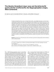
Fig. 2. The site <strong>of</strong> the Attu gold prospect.<br />
Gold values are given for rock samples.<br />
Red circles are sample sites with gold values<br />
obtained from fine-grained stream sediments<br />
(see Fig. 1 for geographical location). The<br />
red line shows the approximate position <strong>of</strong><br />
the gold-bearing zone in the shear/mylonite<br />
zone. The black line shows the approximate<br />
position <strong>of</strong> a stream.<br />
12 ppb Au<br />
17 ppb Au<br />
2–6 ppm Au<br />
< 0.5% Cu<br />
2.24 ppm Au<br />
0.34% Cu<br />
124 ppb Au<br />
0.<strong>11</strong>% Cu<br />
different lithologies. Major fault zones generally strike<br />
NNE to NE. The major Nordre Strømfjord shear zone<br />
(van Gool 2002) is located c. 20 km south <strong>of</strong> the study<br />
area. The shear zone is traceable from the coast to the<br />
Inl<strong>and</strong> Ice <strong>and</strong> forms the southern boundary <strong>of</strong> the NNO.<br />
The gneisses <strong>of</strong> the NNO are late Archaean, with ages<br />
between 2870 <strong>and</strong> 2700 Ma (Kalsbeek & Nutman 1996;<br />
Connelly & Mengel 2000; Hollis et al. 2006, this volume;<br />
Thrane & Connelly 2006, this volume). Discordant sheets<br />
<strong>of</strong> granitoid rocks <strong>of</strong> Archaean age occur in the centre <strong>of</strong><br />
the NNO <strong>and</strong> large charnockite/granite bodies including<br />
the Rifkol granite are situated 20 km to the northwest<br />
<strong>and</strong> just south <strong>of</strong> the study area (Fig. 1; Hansen 1979;<br />
Kalsbeek et al. 1984). Only a few younger Palaeoproterozoic<br />
ages have been obtained from the NNO: Thrane &<br />
Connelly (2006, this volume) have obtained an approximate<br />
depositional age <strong>of</strong> the Naternaq supracrustal belt<br />
some 80 km north-east <strong>of</strong> Attu <strong>of</strong> c. 1950–1900 Ma, <strong>and</strong><br />
an undeformed pegmatite between Attu <strong>and</strong> Aasiaat has<br />
yielded an age <strong>of</strong> c. 1790 Ma (Connelly & Mengel 2000).<br />
The Attu gold prospect<br />
The Attu gold prospect is located south <strong>of</strong> the village Attu<br />
within a 100–330 m wide, complex tract hosting several<br />
parallel shear/mylonite zones <strong>and</strong> faults that strike<br />
NNE to NE <strong>and</strong> dip 60–70 ° W (Figs 1, 2). The fault zone<br />
can be followed along strike in a north-easterly direction<br />
for several kilometres. The host rocks are layered, brown<br />
Fig. 3. Layered brown gneiss with black<br />
b<strong>and</strong>s <strong>of</strong> amphibolite. The hammer shaft is<br />
50 cm long.<br />
55