GOLD ENVIRONMENTS AND FAVOURABILITY
GOLD ENVIRONMENTS AND FAVOURABILITY
GOLD ENVIRONMENTS AND FAVOURABILITY

You also want an ePaper? Increase the reach of your titles
YUMPU automatically turns print PDFs into web optimized ePapers that Google loves.
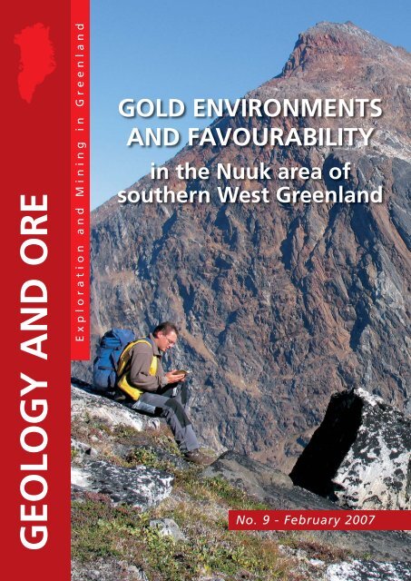
<strong>GOLD</strong> <strong>ENVIRONMENTS</strong><strong>AND</strong> <strong>FAVOURABILITY</strong>in the Nuuk area ofsouthern West GreenlandNo. 9 - February 2007
GEOLOGY <strong>AND</strong> ORE 9 / 2007<strong>GOLD</strong> <strong>ENVIRONMENTS</strong> <strong>AND</strong><strong>FAVOURABILITY</strong>in the Nuuk area of southern West GreenlandSo far the interplay between the magmatic,tectonic and metamorphic evolutionsand their mineralising eventshas been the main resource evaluation.During the last couple of years,focus on the primary geological environmenthosting the mineral depositshas started to improve the evaluations.Multidisciplinary, spatial, quantitativeanalysis of geo-data is usedfor this purpose. The construction ofquantitative, favourability maps for aspecific element, such as gold, is aresult of this.The “new” approach has been usedin the Nuuk region in West Greenland,where the statistical, spatial analysishas been used to evaluate the goldpotential. The analysis also providesvaluable input to the interpretation ofthe mineralisation and the primary geologicalenvironments.Geological environments andmineralisation in the Nuuk regionThe Nuuk region, located within the ArchaeanNorth Atlantic craton (the Nain cratonin Canada), comprises several differenttectono-stratigraphic terranes, which hadindependent, geological evolution until theywere tectonically assembled at c. 2.7 Ga.The terranes host several supracrustal belts;the oldest is the Isua greenstone belt withan age of c. 3.8 Ga and younger belts areMesoarchaean. The different belts and areasare described according to their dominatingenvironment.Volcaniclastic, meta-andesitic rock fromBjørneøen with fiamme textures.The Qingaaq gold prospect at Storø located within a supracrustal sequence. The prospect is currentlybeing drilled and evaluated by NunaMinerals A/S. The lake in the lower left corner is 470 m abovesea level. The top in the background is the mountain Qingaaq (1616 m. a.s.l.), and the top in theforeground is Little Qingaaq (1070 m.a.s.l). Photo courtesy: NunaMinerals A/S.The investigations of the environmentsrequire the combination of detailed geologicalmapping, geochemistry, petrographywork, isotope work and geochronologicalstudies.Island-arc environmentRecently volcaniclastic rocks of andesiticcomposition were discovered in the region.The belt forms major parts of the Mesoarchaean,amphibolite facies supracrustalbelt around Qussuk bay, on central andeastern Bjørneøen and on central Storø(3071 Ma). Meta-volcanic rocks have beensubject to intense synvolcanic hydrothermalalteration associated with gold-coppermineralisation (grab samples with up to 2g/t Au). Later hydrothermal events mayalso have affected the occurrences of goldin certain areas.The Ivisaartoq supracrustal belt, with amaximum age of 3075 Ma, is interpretedas a forearc supra-subduction environment.This belt underwent at least twostages of calc-silicate, metasomatic alterationbetween 3075 and 2963 Ma attrib-2
<strong>GOLD</strong> <strong>ENVIRONMENTS</strong> <strong>AND</strong> <strong>FAVOURABILITY</strong>52°W Sillissianguit51°W50°WIsua GreenstonebeltInlandIceIsukasiaNagssugtoqidianorogenSimplified schematic geologicalmap of the Nuukregion with general indicationof different geologicalenvironments.Outlines of the rock unitsare from digital versionsof 1:100 000 and 1:2500 000 scale geologicalmaps published by theSurvey.Q: Qingaaq;A: Aappalaartoq;S: Seqi Olivine mine.The statistically definedgroups of gold showingsin the region are alsoindicated (a gold showingis defined as a localitywhere in situ rock samplesyielded 1 g/t Au).65°NDavisStrait64°30'NFiskefjordNordlandetNuukSGodthåbsfjordSermitsiaqQussukBjørneøenAmeralikQ AQooqqutStorøIvisaartoqGodthåbsfjord25 kmNorthAtlanticcratonNuukregionKetilidianorogenGneiss -infracrustalMajor faults andshear zonesSupracrustalenvironments:UnknownIsland ArcOcean FloorMagmaticGroups of goldshowings:Isua gold groupBjørneøen gold groupStorø gold groupUngroup showingsuted to seafloor hydrothermal alteration.The Ivisaartoq belt hosts volcanic massivesulphide deposits (semi-massive to massivepyrite-pyrrhotite) and disseminated tungstenin altered komatiites (channel sampleswith 0.44% WO 3 over 2.5 m). Showingswith up to 3.5 g/t Au are recorded withinthe Ivisaartoq belt.Ocean-floor environmentThe 3.8 Ga Isua greenstone belt representsan ocean-floor environment. The dominatingrock types in this belt are pillow-structuredtholeiitic and high Mg-basaltic rockswith intercalated, extensive bands of chertand banded iron formation, turbidites aswell as garnet-mica schist representingmetamorphosed sediments. Gold occurrenceshave been found in several settingswithin the Isua greenstone belt.• In silicate facies iron formation(up to 1.2 g/t Au)• In fuchsite-stained quartz-rich rocks(up to 3.1 g/t Au over 3 m)• In shear-zone hosted, carbonatealteredultrabasic rocks (grab sampleswith up to 100 g/t Au).A hydrothermal episode affected a c.3.8 Ga intrusive tonalite sheet in the westernpart of the Isua greenstone belt. Thebelt contains up to 14% combined Pb andZn with up to 6.8 g/t Au and 180 g/t Ag.Well-preserved, volcanic successionsinterpreted as environments dominated byocean-floor settings are described fromseveral other areas in the Nuuk region. Bimodal,volcanic succession in greenschistfacies is described from the ‘Nunatak 1390’in the Tasiuarsuaq terrane. Voluminouslylayered amphibolites and well-preservedpillow lava at Bjørneøen, associated withhomogenous, metagabbroic amphiboliteare also interpreted as a primary oceanfloor environment. A small VMS showingis located in the south-western part of thebelt at Bjørneøen. This showing containsup to 3.55% Zn, 1.33% Pb, 33 g/t Agand 0.153 g/t Au.Magmatic environmentThe Nordlandet and Fiskefjord areas aredominated by mafic to ultramafic sequencesincluding dunite, peridotite, pyroxenite,norite and amphibolites hosted by tonaliticand trondhjemitic gneisses. In manycases relict magmatic layering is preserved.This area comprises probably both primarymagmatic environments and relicts ofgreenstone belts. The mafic to ultramaficcomplexes south of Fiskefjord show enhancedvalues of Au and PGE. The SeqiOlivine Mine operated by Minelco AB islocated just north of central Fiskefjord.The deposit contains at least 100 milliontonnes of high-quality olivine and is hostedwithin a large dunite body.The supracrustal belt at central Storø isof a complex character and much debated.It seems that this belt may contain characteristicsof both continental and oceanicvolcanic and sedimentary rocks. The areais furthermore affected by intense foldingand major shearing, making straight interpretationseven more difficult. The area mayrepresent an accretion environment alongboundaries of different terranes (amalgamatedaround 2.7 Ga). Central Storø hoststhe Qingaaq Gold prospect which is investigatedand drilled by NunaMinerals A/S.Several gold bearing structures, 4–36 mwide, have been found at Qingaaq withgrades from 0.5 to 6 g/t Au and locally2–4 m wide zones with grades up to 20g/t Au.3
<strong>GOLD</strong> <strong>ENVIRONMENTS</strong> <strong>AND</strong> <strong>FAVOURABILITY</strong>GEOLOGY <strong>AND</strong> ORE 9 / 2007Deformed pillow lava fromsouthern part of Bjørneøen.Mineral potential - addressingmultivariable datasetsVisual inspection and comparison of e.g.lithological, topographical, geochemicaland geophysical maps are necessary waysof interpreting geological features acrosspoorly exposed or little explored areas. Inmineral exploration the maps and data areused visually to identify anomalies believedto reflect the existence of mineral occurrences.However, if the regional data arewidely spaced, and if the occurrences areof limited size or poorly exposed, the anomaliesmay be too subtle to be recognisedby a simple visual approach. In such cases,statistical data analyses may help identifydeviations from the background variationsand trends in the data. Furthermore, visuallybased correlation between distributionsis often limited to a few parameters andwith the wealth of to-day’s digital data,multivariable relationships are easily overlookedor not possible to deduce visually.the case of gold potential in a region, pixelswith and without gold showings areregistered. To construct a gold favourabilitymap includes analysing the characteristicdata signatures of the pixels, with andwithout gold showings, in multiple datasetsand then integrating the data signatureto calculate the gold showing probabilityfor each pixel. Besides enabling thequantification of the gold favourability ina certain area, the statistical approach providesquantitative signatures of specificgeological features, e.g. the gold showings,which can be used and integrated ingeological models and interpretations.The principles of the statisticalmethodologyAll spatial datasets are converted info aform, where they can be compared andsubjected to statistical analysis. Each datasetis presented as a regular grid using acommon grid cell size denoted a pixel. InRusty chromite-magnetite banding from magmatic layered norite in the Fiskefjord area.4
<strong>GOLD</strong> <strong>ENVIRONMENTS</strong> <strong>AND</strong> <strong>FAVOURABILITY</strong>GEOLOGY <strong>AND</strong> ORE 9 / 2007Rust zone in massive sulphide occurrence at Ivisaartoq.Gold favourability map for theNuuk regionData analysedSixty-nine different geoscientific datasets –including location of known gold showings,data from geological maps, streamsediment geochemistry, aeromagnetic data,aeroradiometric data and data from lineamentanalysis have so far been included inthe statistical analysis. All datasets are pixelated.A gold showing is in the currentstudy defined as a locality where a rockgrab sample has yielded >1 g/t Au.Resulting gold favourability mapBy using the identified common signaturefor gold showings, it is possible to estimatethe probability for similar data signatureswithin all pixels. It is not surprising thatareas immediately surrounding known goldshowings are predicted as favourable, butmore interestingly, a number of favourableareas are also predicted outside areas withknown gold showings.Grouping of gold showingsInstead of treating all known gold showingsas one group, it is statistically analysedwhether the showings should be splitinto groups according to common signaturesin the datasets. For the Nuuk region,this analysis resulted in the identificationof at three main groups of gold showings:the Storø, the Bjørneøen and the Isuagroup.Gold bearing rustzone in the Qussuk area.6
<strong>GOLD</strong> <strong>ENVIRONMENTS</strong> <strong>AND</strong> <strong>FAVOURABILITY</strong>Top 137 km 2 most gold favourable area (1% of entire study area)52°W 51°W50°WInlandIceIsukasia65°NNuukregionIceGneissAmphiboliteMetasedimentUltramafic rockLate Archaean granitesFault and shear zonesIsua showingsBjørneøen showingsStorø showingsUngrouped showingsThe top 137 km 2 and 685 km 2most favourable areas for:Isua gold groupDavisStrait64°30'NFiskefjordNuukGodthåbsfjordSermitsiaqBjørneøenAmeralikStorøAQQooqqutIvisaartoqGodthåbsfjord25 kmBjørneøen gold groupStorø gold groupTop 685 km 2 most gold favourable area (5% of entire study area)52°W 51°W50°WInlandIceSimplified geological maps with the toprated 137 km 2 and 685 km 2 (respectively1% and 5% of the analysed area) outlinedas most gold favourable area for the threegroups of gold showings (Isua, Bjørneøenand Storø groups). Outlines of the rockunits are from digital versions of 1:100 000and 1:2 500 000 scale geological mapspublished by GEUS.65°NDavisStraitFiskefjordIvisaartoqIsukasiaBjørneøen64°30'NGodthåbsfjordStorøAQGodthåbsfjordSermitsiaqQooqqutNuukAmeralik25 km7
<strong>GOLD</strong> <strong>ENVIRONMENTS</strong> <strong>AND</strong> <strong>FAVOURABILITY</strong>GEOLOGY <strong>AND</strong> ORE 9 / 2007Rust zone with 377 ppb Au in quartz-veined amphibolite, central Fiskefjord.Some of the most notable areas outlinedas most favourable for gold are eastof the fjord Qooqqut, areas at Storø, areasat Sermitsiaq, areas south and west ofIsuakasia and areas in outer and inner partof Fiskefjord. Especially in the latter area,hardly any prospecting for gold has beendone, but the area comprises bothsupracrustal rocks and structures that aresimilar to those in areas with known goldshowings. Field work in the inner part ofFiskefjord recently revealed a strong alterationof the country rock in that area;mainly bleaching, silicification and epidotization.Rocks from the area yield elevatedgold content with up to 0.377 g/t Au inamphibolite-hosted quartz veins.The spatial distributionThe spatial distribution of all outlined favourableareas suggests the existence of a mainregional tract favourable for gold and goldmineralising environments. Most of the favourableareas for the different groups ofknown gold showings are situated within aNormalised frequencyNormalised frequency0.80.60.40.20.03.22.41.60.80.02Isua grou pBjørneøen grou pStorø grou pBackground2 6 10 14 18 22 26 30As [ppm]3 4 5Cs [ppm]6Normalised frequencyNormalised frequency0.160.120.080.040.005 15 25 35 45 55Ni/Mg ratio8.06.04.02.00.0-0.6 -0.4 -0.2 0.0 0.2 0.4 0.6Vertical gradient of total magneticintensity field [nT/m]Four examples of statistically derived data signatures for the three main groups of gold showings inthe Nuuk region, displayed together with the background signature (pixels without any gold showings).8
<strong>GOLD</strong> <strong>ENVIRONMENTS</strong> <strong>AND</strong> <strong>FAVOURABILITY</strong>Godthaabsfjord(~2.63 Ga)PegmatiteTourmaline, beryl,U, Th, REEQingaaqAappalaartoq(~2.85 Ga)Hydrothermal,AuSillissisanguit(~3.03 Ga)MagmaticNi, Cu, PGEQussukBjørneøen(~3.07 Ga)VMS, hydrothermalAu, Cu, Zn, PbIvisaartoq(~3.075 Ga)HydrothermalAu, WIsuakasia(~3.8 Ga)BIFAu, FeSeqi(~3.03 Ga)MagmaticOlivineCalc-alkalinevolcanismContinetalmarginIslandarcQôrqutgraniteBack-arcbasinBi-modalvolcanismMidoceanicriftGraniteTTGUltramaficintrusionGraniteintrusionsUltramaficmaficintrusionsUltramafic-maficintrusionsBasalticmagmatismShieldFault-/shearzonesuture zoneEmpirical simplified model of geological environments and mineral occurrences present in the Nuuk region.NNE-trending tract from the town of Nuukto Isukasia. The tract embraces most ofthe previously known gold showings inthe region as well as geochemical goldanomalies, and the zone has previouslybeen suggested as being prospective forgold.The NNE-trending tract outlined asbeing favourable for gold is common tothe general orientation of the supracrustalbelts in this area and to the regional largescalefaults. In general, supracrustal unitsoutside the tract constitute similar proportions,but these are not indicated as beingwithin the most favourable areas by thepresent statistical analysis. This indicatesthat the supracrustal units within the tractdeviate from those outside.group poses a problem in the search forareas holding a potential for new showings.Since this signature exists on Storøsolely, this area will be outlined as favourableonly for the Storø group. Consequently,the As data are omitted in the calculationof pixels with a potential for Storøtypeshowings. It has before been arguedthat Cs may be considered a pathfinderelement for gold mineralisation associatedwith granite-related, hydrothermal alteration.The signature for Cs in stream sedimentconfirms that the gold at Storø andBjørneøen is indeed located in a Cs-richenvironment, but also suggests that themineralisation at Isua has a different nature.The last example illustrates the indicatedsignificance of the vertical gradient of thetotal magnetic field intensity (denotedVGTMI). This signature for the Storø andBjørneøen groups (–0.2 to 0.1 nT/m) is identicalto the background signature, and isconsequently regarded as non-indicative forthese groups. The Isua group has a moredispersed signature (–0.5 to 0.8 nT/m), withan indicative positive and negative VGTMIthan the other groups. This probably reflectslocal-scale changes in lithology. Other datasets,which yield a characteristic signature ofone or more of the groups of gold showings,are the Au, Cs, Rb, La, Th, and U concentrationsin stream sediment geochemisty.Signatures of gold showingsThe systematic construction of data signaturesof showings and the backgrounddraw attention to the significance of parametersthat are not immediately or traditionallyregarded as indicative of gold mineralisation.It has previously been establishedthat the combination of elevated Asin stream sediment and gold mineralisationhas not been found outside Storø. However,the possible significance of the Ni/Mgratio in relation to gold has not previouslybeen substantiated in a quantitative way.This observation is an incentive to conductfurther studies of host rock properties interms of their Ni and Mg behaviour. Therare and unique As signature of the StorøVisible gold in drill core from the Storø prospect. Photo: NiunaMinerals A/S.9
<strong>GOLD</strong> <strong>ENVIRONMENTS</strong> <strong>AND</strong> <strong>FAVOURABILITY</strong>GEOLOGY <strong>AND</strong> ORE 9 / 2007PerspectivesThe statistical approach has a potential ofidentifying and mapping other types ofmineral occurrences as well as specific tectonicunits in poorly known areas and canbe used on local or regional scale, dependingon the resolution of the involved datasets.The statistical approach has been usedto examine gold showings in a moderatelyexplored region.The approach could also be applied toeconomic deposits from well-known historicor active mining camps. As shown inthe case in the Nuuk area, the statisticalapproach should always be used in combinationwith other geological approaches.The results of a statistical analysis shouldbe cross-validated and critically balancedaccording to geological knowledge.Concluding remarksThe detailed investigations of primary geologicalenvironments of supracrustal rocksin the Nuuk region have revealed a greatdiversity in environments, which all carrygold. The results from the statistical analysishave been positive in the sense thatareas with high favourability for new goldoccurrences have been outlined.Hydrothermal alteration with epidotization,south of Ameralik fjord.10
GEMSTONES OF GREENL<strong>AND</strong>Drill cores are lifted by helicopter duringoperation at Little Qingaaq. Photo courtesy:NunaMinerals A/S.11
GEOLOGY <strong>AND</strong> ORE 9 / 2007Bureau of Minerals and Petroleum(BMP)Government of GreenlandP.O. Box 930DK-3900 NuukGreenlandTel: (+299) 34 68 00Fax.: (+299) 32 43 02E-mail: bmp@gh.glInternet: www.bmp.glGEOLOGY <strong>AND</strong> ORE 7 / 2007Gold-mineralised quartz veins hosted in amphibolite at the Qingaaq gold prospect,central Storø.Key referencesGeological Survey of Denmarkand Greenland (GEUS)Øster Voldgade 10DK-1350 Copenhagen KDenmarkTel: (+45) 38 14 20 00Fax.: (+45) 38 14 20 50E-mail: geus@geus.dkInternet: www.geus.dkAppel, P.W.U., Coller, D., Coller, V., Heijlen, W.,Moberg, E., Polat, A.,Raith, J., Schjøth, F.,Stendal, H. & Thomassen, B. (2005): Is therea gold province in the Nuuk region? Danmarksog Grønlands Geologiske Undersøgelse Rapport2005/27, 79 pp., 1 CD-ROM.Eilu, P., Garofalo, P., Appel, P.W.U. & Heijlen,W. (2006): Alteration patterns in Au-mineralisedzones of Storø, Nuuk region – West Greenland.Danmarks og Grønlands Geologiske UndersøgelseRapport 2006/30, 73 pp.Garde, A.A. (in press): A mid-Archaean islandarc complex in the eastern Akia terrane, Godthåbsfjord,southern West Greenland. Journal ofGeological Society.Hollis, J.A., van Gool, J.A.M., Steenfelt, A. &Garde, A.A. (2005): Greenstone belts in thecentral Godthåbsfjord region, southern WestGreenland. Geological Survey of Denmark andGreenland Bulletin 7, 65–68.Hollis, J.A., Schmid, S., Stendal, H., van Gool,J.A.M. & Weng, W.L. (2006): Progress report onthe 2005 field work: geological mapping, regionalhydrothermal alteration and tectonic sections.Danmarks og Grønlands Geologiske UndersøgelseRapport 2006/7, 171 pp.Juul-Petersen,A., Frei, R. Appel, P.W.U.,Persson,M. & Konnerup_Madsen, J. (in press):A sher zone related greenstone belt hosted goldmineralization in the Archean of West Greenland.A petrographic and combined Pb-Pb and Rb-Srgeochronological study. Ore Geology Reviews(2007).Stendal, H., Secher, K., Nielsen, B.M., Schønwandt,H.K. & Thorning, L. (2005): Greenlandgeological environments and mineral resources.Danmarks og Grønlands Geologiske UndersøgelseRapport 2005/8, 207 pp.Stensgaard, B.M., Chung, C., Rasmussen, T.M.& Stendal, H. (in press): Assessment of mineralpotential using cross-validation techniques andstatistical analysis: A case study from thePaleoproterozoic of West Greenland. EconomicGeology, 101.Steensgaard, B.M., Steenfelt, A. & Rasmussen,T.M. (2006): Gold potential of the Nuuk regionbased on multi-parameter spatial modelling.Progress 2005. Danmarks og Grønlands GeologiskeUndersøgelse Rapport 2006/27, 207 pp.Polat, A., Appel, P.W.U., Frei, R., Pan, Y., Dilek, Y.,Ordóñes-Calderón, J.C., Fryer, B., Hollis, J.A.& Raith, J.G. (2007): Field and geochemicalcharacteristics of the Mesoarchean (~3075 Ma)Ivisaartoq greenstone belt, southern WestGreenland: Evidence for seafloor hydrothermalalteration in supra-subduction oceanic crust.Gondwana Research 11, 69–91.Front cover photographThe mountain Aappalaartoq (1440 m) –named after the Greenlandic word forred mountain – in the background.Several gold-bearing structures havebeen located within the supracrustalpackage making up the mountain. Photocourtesy: NunaMinerals A/S.AuthorB.M. Stensgaard & H. Stendal, GEUSEditorKarsten Secher, GEUSGraphic ProductionCarsten E. Thuesen, GEUSPhotographsGEUS unless otherwise statedPrintedJanuary 2007 © GEUSPrintersSchultz Grafisk12ISSN1602-818x