Mangrove wetland ecosystems in Ganges-Brahmaputra delta in ...
Mangrove wetland ecosystems in Ganges-Brahmaputra delta in ...
Mangrove wetland ecosystems in Ganges-Brahmaputra delta in ...

Create successful ePaper yourself
Turn your PDF publications into a flip-book with our unique Google optimized e-Paper software.
444 Shafi Noor ISLAM, Albrecht GNAUCK<br />
The data was processed and analyzed through MS Excel,<br />
GISArcView 9.1 for data visualization and MATLAB<br />
software version 7.1 were used for simulation.<br />
6 Results and discussion<br />
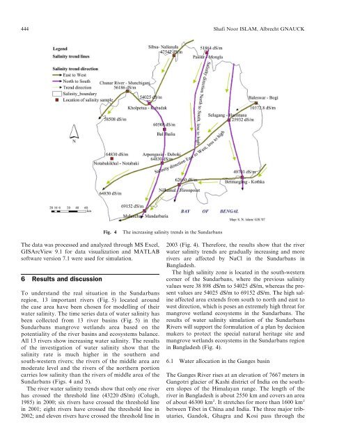
To understand the real situation <strong>in</strong> the Sundarbans<br />
region, 13 important rivers (Fig. 5) located around<br />
the case area have been chosen for modell<strong>in</strong>g of their<br />
water sal<strong>in</strong>ity. The time series data of water sal<strong>in</strong>ity has<br />
been collected from 13 river bas<strong>in</strong>s (Fig. 5) <strong>in</strong> the<br />
Sundarbans mangrove <strong>wetland</strong>s area based on the<br />
potentiality of the river bas<strong>in</strong>s and <strong>ecosystems</strong> balance.<br />
All 13 rivers show <strong>in</strong>creas<strong>in</strong>g water sal<strong>in</strong>ity. The results<br />
of the <strong>in</strong>vestigation of water sal<strong>in</strong>ity show that the<br />
sal<strong>in</strong>ity rate is much higher <strong>in</strong> the southern and<br />
south-western rivers; the rivers of the middle area are<br />
moderate level and the rivers of the northern portion<br />
carries low sal<strong>in</strong>ity than the rivers of middle area of the<br />
Sundarbans (Figs. 4 and 5).<br />
The river water sal<strong>in</strong>ity trends show that only one river<br />
has crossed the threshold l<strong>in</strong>e (43220 dS/m) (Colugh,<br />
1985) <strong>in</strong> 2000; six rivers have crossed the threshold l<strong>in</strong>e<br />
<strong>in</strong> 2001; eight rivers have crossed the threshold l<strong>in</strong>e <strong>in</strong><br />
2002; and eleven rivers have crossed the threshold l<strong>in</strong>e <strong>in</strong><br />
Fig. 4 The <strong>in</strong>creas<strong>in</strong>g sal<strong>in</strong>ity trends <strong>in</strong> the Sundarbans<br />
2003 (Fig. 4). Therefore, the results show that the river<br />
water sal<strong>in</strong>ity trends are gradually <strong>in</strong>creas<strong>in</strong>g and more<br />
rivers are affected by NaCl <strong>in</strong> the Sundarbans <strong>in</strong><br />
Bangladesh.<br />
The high sal<strong>in</strong>ity zone is located <strong>in</strong> the south-western<br />
corner of the Sundarbans, where the previous sal<strong>in</strong>ity<br />
values were 38 898 dS/m to 54025 dS/m, whereas the present<br />
values are 54025 dS/m to 69152 dS/m. The high sal<strong>in</strong>e<br />
affected area extends from south to north and east to<br />
west direction, which is poses an extremely high threat for<br />
mangrove <strong>wetland</strong> <strong>ecosystems</strong> <strong>in</strong> the Sundarbans. The<br />
results of water sal<strong>in</strong>ity simulation of the Sundarbans<br />
Rivers will support the formulation of a plan by decision<br />
makers to protect the special natural heritage site and<br />
mangrove <strong>wetland</strong>s <strong>ecosystems</strong> <strong>in</strong> the Sundarbans region<br />
<strong>in</strong> Bangladesh (Fig. 4).<br />
6.1 Water allocation <strong>in</strong> the <strong>Ganges</strong> bas<strong>in</strong><br />
The <strong>Ganges</strong> River rises at an elevation of 7667 meters <strong>in</strong><br />
Gangotri glacier of Kashi district of India on the southern<br />
slopes of the Himalayan range. The length of the<br />
river <strong>in</strong> Bangladesh is about 2550 km and covers an area<br />
of about 46300 km 2 . It stretches for more than 1600 km 2<br />
between Tibet <strong>in</strong> Ch<strong>in</strong>a and India. The three major tributaries,<br />
Gandok, Ghagra and Kosi pass through the