Visitor Guide NSW National Parks 2011 - Hke Sydney
Visitor Guide NSW National Parks 2011 - Hke Sydney
Visitor Guide NSW National Parks 2011 - Hke Sydney

Create successful ePaper yourself
Turn your PDF publications into a flip-book with our unique Google optimized e-Paper software.
Lane Cove, Ku-ri-gai, þe Royal... <strong>Sydney</strong>’s<br />
bustli suburbs stop where þese natural treasures<br />
begin. Grn spaces þat let þe city breaþe.<br />
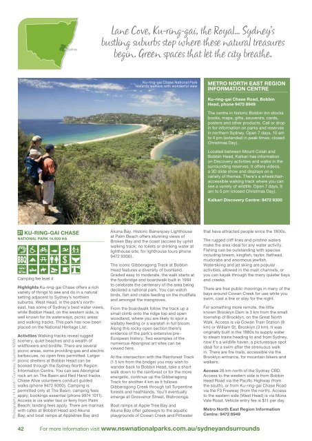
Ku-ring-gai Chase <strong>National</strong> Park<br />
rewards walkers with wonderful view<br />
METRO NORTH EAST REGION<br />
INFORMATION CENTRE<br />
Ku-ring-gai Chase Road, Bobbin<br />
Head, phone 9472 8949<br />
The centre in historic Bobbin Inn stocks<br />
books, maps, gifts, souvenirs, cards,<br />
posters and other products. Call or drop<br />
in for information on parks and reserves<br />
in northern <strong>Sydney</strong>. Open 7 days, 10 am<br />
to 4 pm (extended in peak times; closed<br />
Christmas Day).<br />
Located between Mount Colah and<br />
Bobbin Head, Kalkari has information<br />
on Discovery activities and walks in the<br />
surrounding reserves. It offers videos,<br />
a 3D slide show and displays on a<br />
variety of themes. There's a wheelchairaccessible<br />
walking track where you can<br />
see a variety of wildlife. Open 7 days, 9<br />
am to 5 pm (closed Christmas Day).<br />
Kalkari Discovery Centre: 9472 9300<br />
Photography: H. Lund / Courtesy Tourism <strong>NSW</strong><br />
21 KU-RING-GAI CHASE<br />
NATIONAL PARK 14,928 HA<br />
Camping fee level 4<br />
Highlights Ku-ring-gai Chase offers a rich<br />
variety of things to see and do in a natural<br />
setting adjacent to <strong>Sydney</strong>’s northern<br />
suburbs. West Head, in the park’s northeast,<br />
has some of <strong>Sydney</strong>’s best water views,<br />
while Bobbin Head, on the western side, is<br />
well known for its waterways, picnic areas<br />
and walking tracks. This park has now been<br />
placed on the <strong>National</strong> Heritage List.<br />
Activities Walking tracks reveal rugged<br />
scenery, quiet beaches and a wealth of<br />
wildflowers and birdlife. There are several<br />
picnic areas, some providing gas and electric<br />
barbecues, no open fires permitted. Larger<br />
picnic shelters at Bobbin Head can be<br />
booked through the <strong>Sydney</strong> North Region<br />
Information Centre. You can see Aboriginal<br />
rock art on The Basin and Red Hand tracks.<br />
Chase Alive volunteers conduct guided<br />
walks (phone 9472 9300). Camping is<br />
permitted only at The Basin; camping fees<br />
apply, bookings essential (phone 9974 1011).<br />
Access is via water taxi or ferry from Palm<br />
Beach; landing fees apply. There are marinas<br />
with cafes at Bobbin Head and Akuna<br />
Bay, and boat ramps at Appletree Bay and<br />
Akuna Bay. Historic Barrenjoey Lighthouse<br />
at Palm Beach offers stunning views of<br />
Broken Bay and the coast (access by uphill<br />
walking track; no toilets or drinking water at<br />
lighthouse site; for lighthouse tours phone<br />
9472 9300).<br />
The iconic Gibberagong Track at Bobbin<br />
Head features a diversity of bushland.<br />
Graded easy to moderate, the walk starts at<br />
the footbridge and boardwalk built in 1994<br />
to celebrate the centenary of the area being<br />
declared a national park. You can watch<br />
birds, fish and crabs feeding on the mudflats<br />
and amongst the mangroves.<br />
From the boardwalk follow the track up a<br />
small climb onto the ridge top and open<br />
woodland, where you are likely to spot a<br />
wallaby feeding or a waratah in full bloom.<br />
Along this rocky open section there’s<br />
evidence of the park’s extensive pre-<br />
European history. Two examples of the<br />
numerous Aboriginal art sites can be<br />
viewed here.<br />
At the intersection with the Rainforest Track<br />
(1.5 km from the bridge) you may wish to<br />
wander back to Bobbin Head, take a short<br />
walk down to the rainforest or for the more<br />
energetic, continue up the Gibberagong<br />
Track for another 4 km as it follows<br />
Gibberagong Creek through tall Turpentine<br />
forests and heathlands. You’ll eventually<br />
emerge at Grosvenor Street, Wahroonga.<br />
Boat ramps at Apple Tree Bay and<br />
Akuna Bay offer gateways to the aquatic<br />
playgrounds of Cowan Creek and Pittwater<br />
that have attracted people since the 1800s.<br />
The rugged cliff lines and pristine waters<br />
make the area ideal for any water activity.<br />
Fishing can be outstanding with species<br />
including bream, kingfi sh, taylor, flathead,<br />
mudcrabs and enormous jewfish.<br />
Waterskiing and jet skiing are popular<br />
activities, allowed in the main channels, or<br />
you can kayak through the many quieter bays<br />
and creeks.<br />
There are free public moorings in many of the<br />
bays around Cowan Creek for use while you<br />
swim, cast a line or stay for the night.<br />
For something more remote, the little<br />
known Brooklyn Dam is 3 km from the small<br />
township of Brooklyn, on the Great North<br />
Walk. Access is via Cowan Train Station (8<br />
km) or William St, Brooklyn (3 km). It was<br />
originally built in the 1880s to supply water<br />
to steam trains heading to and from <strong>Sydney</strong>,<br />
now it’s a wildlife haven, a picturesque spot<br />
ideal for a swim after the strenuous walk<br />
in. There are fire trails, accessible via the<br />
Brooklyn entrance, for mountain bikers and<br />
walkers.<br />
Access 26 km north of the <strong>Sydney</strong> CBD.<br />
Access to the western side is from Bobbin<br />
Head Road via the Pacific Highway (from<br />
the south), or from Ku-ring-gai Chase Road<br />
via the F3 Freeway (from the north). Access<br />
to the eastern side (West Head) is via Mona<br />
Vale Road. Vehicle entry fee is $11 per day.<br />
Metro North East Region Information<br />
Centre: 9472 8949<br />
42 For more information visit www.nswnationalparks.com.au/sydneyandsurrounds