BIODIVERSITY OF CROATIA
BIODIVERSITY OF CROATIA
BIODIVERSITY OF CROATIA

Create successful ePaper yourself
Turn your PDF publications into a flip-book with our unique Google optimized e-Paper software.
SURFACE W<br />
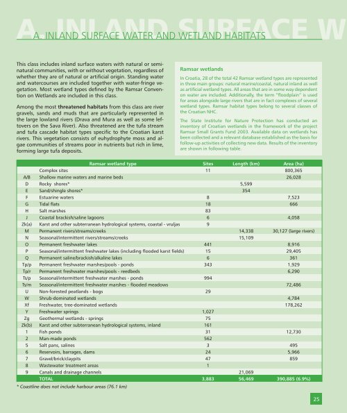
A. INLAND SURFACE WATER AND WETLAND HABITATS<br />
This class includes inland surface waters with natural or seminatural<br />
communities, with or without vegetation, regardless of<br />
whether they are of natural or artificial origin. Standing water<br />
and watercourses are included together with water-fringe vegetation.<br />
Most wetland types defined by the Ramsar Convention<br />
on Wetlands are included in this class.<br />
Among the most threatened habitats from this class are river<br />
gravels, sands and muds that are particularly represented in<br />
the large lowland rivers (Drava and Mura as well as some leftovers<br />
on the Sava River). Also threatened are the tufa stream<br />
and tufa cascade habitat types specific to the Croatian karst<br />
rivers. This vegetation consists of euhydrophyte moss and algae<br />
communities of streams poor in nutrients but rich in lime,<br />
forming large tufa deposits.<br />
Ramsar wetlands<br />
In Croatia, 28 of the total 42 Ramsar wetland types are represented<br />
in three main groups: natural marine/coastal, natural inland as well<br />
as artificial wetland types. All areas that are in some way dependent<br />
on water are included. Additionally, the term “floodplain” is used<br />
for areas alongside large rivers that are in fact complexes of several<br />
wetland types. Ramsar habitat types belong to several classes of<br />
the Croatian NHC.<br />
The State Institute for Nature Protection has conducted an<br />
inventory of Croatian wetlands in the framework of the project<br />
Ramsar Small Grants Fund 2003. Available data on wetlands has<br />
been collected and a relevant database established as the basis for<br />
follow-up activities of collecting new data. Results of the inventory<br />
are shown in following table.<br />
Ramsar wetland type Sites Length (km) Area (ha)<br />
Complex sites 11 800,365<br />
A/B Shallow marine waters and marine beds 26,028<br />
D Rocky shores* 5,599<br />
E Sand/shingle shores* 354<br />
F Estuarine waters 8 7,523<br />
G Tidal flats 18 666<br />
H Salt marshes 83<br />
J Coastal brackish/saline lagoons 6 4,058<br />
Zk(a) Karst and other subterranean hydrological systems, coastal - vruljas 9<br />
M Permanent rivers/streams/creeks 14,338 30,127 (large rivers)<br />
N Seasonal/intermittent rivers/streams/creeks 15,109<br />
O Permanent freshwater lakes 441 8,916<br />
P Seasonal/intermittent freshwater lakes (including flooded karst fields) 15 29,405<br />
Q Permanent saline/brackish/alkaline lakes 6 361<br />
Tp/p Permanent freshwater marshes/pools - ponds 343 1,929<br />
Tp/r Permanent freshwater marshes/pools - reedbeds 6,290<br />
Ts/p Seasonal/intermittent freshwater marshes - ponds 994<br />
Ts/m Seasonal/intermittent freshwater marshes - flooded meadows 72,486<br />
U Non-forested peatlands - bogs 29<br />
W Shrub-dominated wetlands 4,784<br />
Xf Freshwater, tree-dominated wetlands 178,262<br />
Y Freshwater springs 1,027<br />
Zg Geothermal wetlands - springs 75<br />
Zk(b) Karst and other subterranean hydrological systems, inland 161<br />
1 Fish ponds 31 12,730<br />
2 Man-made ponds 562<br />
5 Salt pans, salines 3 495<br />
6 Reservoirs, barrages, dams 24 5,966<br />
7 Gravel/brick/claypits 47 859<br />
8 Wastewater treatment areas 1<br />
9 Canals and drainage channels 21,069<br />
TOTAL 3,883 56,469 390,885 (6.9%)<br />
* Coastline does not include harbour areas (76.1 km)<br />
25