Ideas Workshop Posters - City of Port Alberni
Ideas Workshop Posters - City of Port Alberni
Ideas Workshop Posters - City of Port Alberni

You also want an ePaper? Increase the reach of your titles
YUMPU automatically turns print PDFs into web optimized ePapers that Google loves.
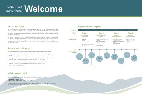
Waterfront<br />
North Study<br />
Welcome<br />
About the project<br />
The <strong>City</strong> <strong>of</strong> <strong>Port</strong> <strong>Alberni</strong>, Hupacasath First Nation, Tseshaht First Nation and the <strong>Port</strong> <strong>Alberni</strong> <strong>Port</strong> Authority have<br />
created an innovative partnership to define a visionary future for <strong>Port</strong> <strong>Alberni</strong>’s Waterfront North. <strong>Port</strong> <strong>Alberni</strong>’s<br />
Waterfront is one <strong>of</strong> the <strong>City</strong>’s most valuable assets - for recreation, commercial activity, economic development<br />
and industry. To understand how <strong>Port</strong> <strong>Alberni</strong> residents would like this important area to improve, we are completing<br />
the Waterfront North Study.<br />
The purpose <strong>of</strong> a waterfront study is to guide future decision-making regarding the preservation, development<br />
and celebration <strong>of</strong> <strong>Port</strong> <strong>Alberni</strong>’s waterfront. The study will assist the project partners in setting priority actions for<br />
recreation investment, land use planning and economic development opportunities. The goal <strong>of</strong> this project is to<br />
develop a collaborative vision for the waterfront north and identify viable and sustainable directions that contribute<br />
to a vibrant <strong>Port</strong> <strong>Alberni</strong>.<br />
Timeline<br />
Phase<br />
Components<br />
Project Process Diagram<br />
Dec. 2012 - Feb. 2013 Feb. 2013 - Apr. 2013 Apr. 2013 - June 2013 June 2013 - July 2013<br />
Phase 1:<br />
Exploring Issues &<br />
Opportunities<br />
• Base mapping<br />
• Site analysis<br />
• Background document review<br />
• Analysis document<br />
• Public workshops #1: Generating <strong>Ideas</strong><br />
• Public input survey<br />
Phase 2:<br />
Creating & Evaluating<br />
Options<br />
• Preliminary planning program and<br />
objectives<br />
• Key character areas review<br />
• Design charrette<br />
• Concept recommendations<br />
• Initial draft review<br />
Phase 3:<br />
Drafting<br />
Recommendations<br />
• Draft plan development and<br />
presentation to partners<br />
• Public workshop #2: Draft Direction<br />
Review<br />
• Public feedback survey<br />
Phase 4:<br />
Finalizing<br />
Recommendations<br />
• Final plan development<br />
• Final plan presentation to<br />
partners<br />
Today is about listening<br />
We are in the early stages <strong>of</strong> the study and we want to hear your ideas. To share your ideas, please:<br />
Key<br />
Consultation<br />
Events<br />
• Talk to us. Members <strong>of</strong> the partnership and the consulting team are here today to discuss your ideas and<br />
feedback.<br />
• Provide your input on the open house boards. Share your hopes and fears, identify opportunities and<br />
challenges, select your favourite precedent images and contribute your vision words.<br />
• Complete a public input survey. The public input survey is available in paper and online and can be completed<br />
here today or at home. Completed response forms are due Friday, March 8 th , 2013.<br />
Start-up<br />
meeting with<br />
partners<br />
Dec. 2012<br />
Public survey<br />
Feb. 2013<br />
Public<br />
<strong>Workshop</strong> #1<br />
Feb. 2013<br />
Design<br />
charrette<br />
April 2013<br />
Initial draft<br />
review with<br />
partners<br />
May 2013<br />
Draft plan<br />
presentation to<br />
partners<br />
June 2013<br />
Public<br />
feedback survey<br />
June 2013<br />
Public<br />
<strong>Workshop</strong> #2<br />
June 2013<br />
Final plan<br />
presentation to<br />
partners<br />
July 2013<br />
• Email us. scott_smith@portalberni.ca<br />
WE ARE<br />
HERE<br />
What happens next<br />
We will use your feedback to help develop a draft vision and preliminary directions for the Waterfront North<br />
Study. These ideas will be explored further at future public events including:<br />
• Stakeholder Charrette - April 2013<br />
• <strong>Workshop</strong> #2: Draft Direction Review - June 2013<br />
Check the project website for event announcements: www.portalberni.ca (click on the<br />
the front table and we’ll send you email nonfictions about the events.<br />
link) or sign-in at
Waterfront<br />
North Study<br />
Did you Know<br />
Interesting Facts from the Waterfront North<br />
What’s in a name<br />
<strong>Port</strong> <strong>Alberni</strong> was named for Captain<br />
Pere d'Alberní, a Spanish <strong>of</strong>ficer, who<br />
commanded Fort San Miguel at Nootka<br />
Sound on Vancouver Island's west coast<br />
from 1790 to 1792.<br />
The name Somass is derived from a Nuuchah-nulth<br />
word that means “washing.”<br />
Nature at our doorstep…<br />
The Somass Estuary is one <strong>of</strong> the most unique environments in BC:<br />
Studies <strong>of</strong> the estuary identified 204 plant species, 20 species <strong>of</strong> special significance and nine<br />
different plant communities – showing more diversity than most estuary environments.<br />
It is one <strong>of</strong> the most important sites on Vancouver Island for wintering and migratory waterfowl.<br />
Reports suggest over 100 species <strong>of</strong> birds use the area for wintering, staging or resting/<br />
feeding, including the blue-listed Trumpeter Swan and Great Blue Heron.<br />
Many mammals have been observed in the estuary, including Columbian Black-tailed Deer,<br />
Black Bear, Beaver, Mink, Red Squirrel, Raccoon, Vagrant Shrew, Townsend’s Vole, Deer Mouse,<br />
Muskrat, River Otter and bats.<br />
Great Blue Heron<br />
Image: Dave & Jocie Ingram<br />
Fascinating culture…<br />
Nature at its fiercest…<br />
Things are kind <strong>of</strong> fishy in <strong>Port</strong> <strong>Alberni</strong>…<br />
Somass River<br />
Image: Erica Watson<br />
The name Kitsuksis is derived from<br />
a Nuu-chah-nulth word meaning “log<br />
across mouth <strong>of</strong> creek.”<br />
Rogers Creek was named after A.B.<br />
Rogers, the discoverer <strong>of</strong> Rogers Pass,<br />
when he surveyed in the <strong>Alberni</strong> Valley<br />
for the Canadian Pacific Railway in the<br />
late 19th century.<br />
Clutesi Haven Marina is named after<br />
George Clutesi, a Tseshaht artist,<br />
actor and writer who was regarded as<br />
a national expert on Native Canadian<br />
culture. In 1959 he received the British<br />
Columbia Centennial Award and the<br />
Canada Centennial Medal in 1967.<br />
Have a whale <strong>of</strong> a time! The Whaling<br />
Monument at Harbour Quay depicts<br />
Nuu-chah-nulth whalers pursuing<br />
a California gray whale. One <strong>of</strong> the<br />
many resources that was utilized<br />
and respected was the whale. This<br />
majestic mammal was looked upon<br />
as one <strong>of</strong> the greatest gifts granted<br />
to the Nuu-chah-nulth by the Creators<br />
and was treated as such by the Nuuchah-nulth<br />
whalers.<br />
Whaling Monument<br />
Image: Kevstan<br />
1964 Tsunami Aftermath<br />
Image: Iain McKain (Province Files)<br />
Just after midnight March 28, 1964<br />
<strong>Port</strong> <strong>Alberni</strong> was hit by a tsunami. The<br />
Tsunami had been triggered by an 8.6<br />
Magnitude earthquake near Anchorage,<br />
Alaska. After a first wave hit, rescuers<br />
worked to evacuate the waterfront area<br />
before the second, larger wave arrived,<br />
cresting at 3m (10’) above the normal high<br />
tide mark. While property damage was<br />
abundant, <strong>Port</strong> <strong>Alberni</strong> was fortunate to<br />
report no casualties from the event.<br />
There are five species <strong>of</strong> Pacific Salmon in the Somass River –<br />
Chinook, Sockeye, Coho, Chum and Pink, as well as summer<br />
and winter steelhead runs.<br />
<strong>Port</strong> <strong>Alberni</strong> is Canada’s Ultimate Fishing Town! In 2010 the<br />
World Fishing Network sponsored a contest for Canada’s<br />
Ultimate Fishing Town and <strong>Port</strong> <strong>Alberni</strong> was the winner. Today,<br />
in Victoria Quay, you’ll find a sign celebrating the achievement.<br />
<strong>Port</strong> <strong>Alberni</strong> Salmon Fest has been celebrated for 41 years. In<br />
recent years, crowds <strong>of</strong> 2,500 have gathered at Clutesi Marina<br />
to participate in the fishing derby and enjoy entertainment.<br />
Canada’s Ultimate Fishing Town<br />
Image: Golder Associates
Waterfront<br />
North Study<br />
Hopes & Fears<br />
Do you have hopes and fears about the future <strong>of</strong> <strong>Port</strong> <strong>Alberni</strong>’s Waterfront North<br />
We asked participants to take a moment to think about their greatest hope and your greatest fear for this area. Participants wrote theirs on a sticky note and attached the note to the appropriate side <strong>of</strong> the board.<br />
Have a look at other participants’ hopes and fears for the Waterfront North.<br />
Train line across river<br />
Greatest hope:<br />
That we can stop traffic<br />
dead in its tracks to<br />
provide and interesting,<br />
educational and<br />
recreational leisurely<br />
time for visitors to stay<br />
& investors to invest in a<br />
tourism area<br />
Hopes<br />
Do something in full<br />
not half-mast<br />
I would like to see a<br />
lively market, either<br />
every Saturday or once<br />
a month. You could get<br />
musicians, different<br />
artisans and food<br />
Aesthetically-pleasing<br />
and - practical,<br />
functional services for<br />
boaters & tourists-<br />
- chandler<br />
- fish processing drop <strong>of</strong>f<br />
- ice/ water/ fuel/<br />
moorage/ temp. tie-ups<br />
Clutesi Marina<br />
This is a very attractive<br />
site for tourists, so in the<br />
future this area should<br />
have variety <strong>of</strong> restaurants,<br />
playground and a flower<br />
garden where the tourist<br />
enjoys the scenery and can<br />
take pictures<br />
Add more stoplights<br />
so people stop and will<br />
slow down and take a<br />
look<br />
Walkway bike lane on<br />
the river when possible<br />
then a boat from east to<br />
Westend<br />
That it won’t hit the mark to<br />
compete with our neighboring<br />
communities and fall<br />
flat. It must be spectacular<br />
and interesting. To make<br />
even a child say “dad lets<br />
stop!” Beautiful for women,<br />
interesting for men. My fear<br />
is also that more non-tourism<br />
businesses will take over!<br />
Lose the estuary is a<br />
big fear<br />
Piece meal loss <strong>of</strong><br />
public access to river<br />
Fears<br />
Industrial pollution<br />
and more ugliness<br />
Protect estuary #1<br />
& Bird sanctuary<br />
(noise encroachment etc.)<br />
It should be studied<br />
before we take a chance<br />
to make anything new.<br />
Sometimes when we make<br />
a decision too quickly it<br />
is not right thing. Please<br />
be thorough<br />
Loss <strong>of</strong> capacity & good<br />
access for recreational<br />
fishers & transient/<br />
tourist boaters<br />
Fishing floats on the<br />
river at the Clutesi<br />
Marina<br />
Continuous walk<br />
from Papermill dam to<br />
Victoria Quay (using<br />
roads where necessary)<br />
I would like to see a<br />
wharf added to the<br />
construction<br />
Industrial growth<br />
Harbour Quay to Victoria<br />
Quay to Papermill Dam<br />
will become a reality -<br />
along its entire length.<br />
That residents will be<br />
inspired & visitors wowed!!<br />
Smoke House in this area<br />
should be restaurant or<br />
fruit plant and small<br />
farming for vegetables<br />
and flowers too<br />
Connect Harbour Quay<br />
to Paper Mill dam<br />
via walkway and/or<br />
current sidewalk w/<br />
signs<br />
Development will scare<br />
bears seen at Victoria<br />
Quay<br />
That we will stop at<br />
the study stage & be<br />
frustrated by lack <strong>of</strong> $.<br />
Lets do the no- and low-<br />
$ projects first
Waterfront<br />
North Study<br />
Vision Statement<br />
What is your vision for <strong>Port</strong> <strong>Alberni</strong>’s future waterfront north<br />
A vision is a guiding statement that sets the tone for long-term planning and development <strong>of</strong> the waterfront.<br />
Help us create a Waterfront North vision by writing 1 - 3 inspiring words on a sticky note and attaching it to this sheet.<br />
Vision for <strong>Port</strong> <strong>Alberni</strong>’s<br />
future waterfront north<br />
is respect their ancestor’s<br />
statues and symbols and<br />
should have (music) or<br />
their spiritual things if<br />
they want to display!<br />
Hooked on us<br />
<strong>City</strong> <strong>of</strong> Strength<br />
(our resources, amenities,<br />
recreation, etc)<br />
Ultimate<br />
<strong>Port</strong> <strong>Alberni</strong>,<br />
Place for family<br />
recreation<br />
Inclusive, sustainable<br />
leisure<br />
To produce an ultimate<br />
fishing town theme below the<br />
tracks & to Clutesi Haven<br />
that envelopes & morphs<br />
into First nations culture &<br />
themed buildings that tells<br />
the story <strong>of</strong> two cultures with<br />
1 common denominator: Fish,<br />
the outdoors, recreation & work.<br />
Take advantage <strong>of</strong> the people<br />
driving by & get them to stop.<br />
Shell you stay awhile<br />
Come and Sea<br />
First Nation’s<br />
Restaurant, so when the<br />
tourists come from T<strong>of</strong>ino<br />
they can eat their food.<br />
Access & viewscapes to<br />
Somass estuary<br />
Fry rearing areas reestablished<br />
in Kitsuksis<br />
estuary & tidal flats -<br />
tourism attractor
MATCHLINE - SEE<br />
INSET BELOW<br />
RUSSELL ST.<br />
RIVER ROAD<br />
Waterfront<br />
North Study<br />
Opportunities & Challenges<br />
6.<br />
Tseshaht FN<br />
Band Hall<br />
SOMASS RIVER<br />
Opportunity:<br />
• Existing municipal park with<br />
play features and river access<br />
Issues:<br />
• No parking<br />
• Limited trail connections<br />
River Road<br />
Park<br />
VIS 285<br />
VIS 2384 PH_1<br />
VIS 285<br />
Opportunity:<br />
• Tseshaht Band Hall is within close<br />
proximity to the study area<br />
7.<br />
YEW ST.<br />
BROWN RD.<br />
VIS 2384 PH_2<br />
VIS 285<br />
Did we miss something<br />
The opportunities and challenges listed are based on initial information gathered from conversations, site visits and background documents.<br />
Participants were asked to share their opportunities, ideas or challenges by:<br />
1. Placing a numbered dot on the approximate location <strong>of</strong> the opportunity or challenge on the map (green for opportunity and red for challenge).<br />
GOLDEN ST.<br />
BROWN RD.<br />
Opportunities:<br />
• River Road is a key transportation corridor<br />
for people travelling to the west coast<br />
• Trail connections could be created<br />
Opportunity:<br />
• Hupacasath Band Hall and House<br />
<strong>of</strong> Gathering are within close<br />
proximity to the study area<br />
Hupacasath FN<br />
Band Hall<br />
Opportunities:<br />
• Community park with multiple amenities<br />
• Connected to the study area by Kitsuksis<br />
Walkway<br />
2. Writing a brief description <strong>of</strong> the opportunity or challenge on the sticky notes provided with the corresponding number.<br />
General Comments:<br />
• Camping would be good for people passing through<br />
• Can’t park your camper/ trailer<br />
• Park and playground down at Harbour Quay or Clutesi Haven<br />
• More artwork by local artists along main highway<br />
• First Nation’s Museum on waterfront (ex. Whistler)<br />
• Find space to include Tyee club that was displaced from the torn down PA building if<br />
new buildings are built. Include meeting space for Tyee club, Kiwanis, Search & Rescue,<br />
<strong>Port</strong> Authority<br />
• <strong>Port</strong> Everett<br />
• Maritime Heritage Society<br />
• Examples <strong>of</strong> successful waterfronts: <strong>Port</strong>land, Stevenston<br />
• Good fishing area – Josephine Street river crossing<br />
• Culture – unique & west coast<br />
• Barclay – tourists, pristine environment<br />
• Caution about swimming<br />
• Concession stands/ mobile vending<br />
• Developing a “camp park” for users <strong>of</strong> Clutesi Marina. We promote tourism – need<br />
parking area for visitors to site. Sadly lacking sufficient amenities for product promoted<br />
Opportunities:<br />
1. Continue Roger Creek boardwalk. Follow it around to Clutesi Marina. Landscape around it<br />
with interpretive kiosks depicting our tsunami<br />
• A neighbourhood pub<br />
2. We require a high-end RV campground<br />
3. Potentially Farmland, not significant wildlife<br />
4. Old Smokehouse Area – First Nation Menu Restaurant, BQ Section, Culture centre<br />
incorporated with restaurant<br />
• First nations restaurant with garden in the back<br />
5. Commemorate the tsunami with an informative sign and high water marker<br />
• Water taxi to Harbour Quay – South <strong>Port</strong> or Summer trolley (free ride)<br />
• Johnston Corridor – Pretty ultimate fishing town, themed with underground<br />
lighting. New metal brackets with our species <strong>of</strong> fish on light posts leading you<br />
down to the river. Realistic art depicting our wildfire. Build in character evolving<br />
from Church that leads you to River Rd where more cultural or West coast style<br />
buildings can be used for commercial<br />
• More art. Realistic looking carved bear with fish in mouth, done by same carver<br />
who did Ultimate Fishing Town Sign.<br />
6. Water transportation – Paper Mill Dam to Clutesi Marina – shuttle transport back<br />
7. Dog park. Nice landscapings to hide from trailer parking<br />
8 Propose funds from sale Catalyst Surplus Lands be applied to overhaul Catalyst<br />
emissions with goal to eliminate stink that gives <strong>Port</strong> a bad rep and keeps people away<br />
9. More agriculture land to grow fresh vegetables and fruit. Also we can grow grain like flax<br />
seed etc.<br />
11. Camping at Paper Mill Dam<br />
12. Full service resort and marina<br />
• Extend boardwalk from Clutesi Marina to Josephine, extend boardwalk from<br />
Victoria Key to Harbour Quay<br />
13. First Nations commercial fishery and nub, pier and docks<br />
• Build reconstructed FN village in partnership with Hupacasath Band at River Rd &<br />
Josephine like at Hazelton called ‘Ksan (Historical Village and Museum)<br />
14. RV Park and Water park<br />
• Kayak business <strong>of</strong>fers opportunities beyond fishing. Good for families – Find<br />
activities for kids – paddleboats, fishing<br />
15. More First Nations development towards fishing, berths, access for river fisherman<br />
16. Single putter double-ender tour boat in estuary/ river<br />
17. Involve Maritime Heritage Society<br />
18. Bioenergy/ energy park along lines <strong>of</strong> Swedish models where Catalyst infrastructure<br />
could be utilized<br />
19. Greenhouse & closed contaminant fish farm using heat and steam from mill<br />
20. Aboriginal village fishing site/ techniques demonstration project. Small hatchery with fish/<br />
seafood restaurant and viewing decks<br />
21. Life size chess set! Local arts market<br />
22. A small museum-type place showing the modern history <strong>of</strong> <strong>Port</strong> <strong>Alberni</strong>. Going back<br />
to the 1950’s when Canada’s highest income town was <strong>Port</strong> <strong>Alberni</strong>, and all the people<br />
worked in the mill and drove nice cars, like ‘American Graffiti.’ Also talking about the<br />
history <strong>of</strong> the waterfront and its influence on the economy and town.<br />
<strong>Ideas</strong> Event Feedback<br />
Challenges:<br />
4. Need for more tidal & side channels to <strong>of</strong>fset the dyking & flood gates<br />
10. Cost <strong>of</strong> doing environmental site investigation and remediating contamination if found<br />
15. Private properties separate people from waterfront<br />
73. Boat launching takes too long. Commercial selling makes waits longer<br />
23. Continue trail to Roger Creek<br />
24. RV Park<br />
25. Marine themed pub<br />
• 6 lane launch ramp, pull through truck and trailer parking, motel amenities, roundabout<br />
access at corner <strong>of</strong> Victoria Quay and Roger St.<br />
26. River Road could be a cycling route<br />
27. Could charge for parking<br />
35. Swimming hole across from Naesgaard’s<br />
36. This place is really good for bigger garden where people come in the summer time and<br />
enjoy<br />
37. Bridge at Josephine to continue boardwalk access coming from Clutesi Marina<br />
• Swimming hole at corner <strong>of</strong> Josephine & River<br />
38. Small aquarium (local species), Bird blind (protection for inclement weather) with<br />
information/ story boards, Promote Stamp Falls fish ladder (a real treasure)<br />
• Catalyst super launch for boats<br />
39. Buy burned out property continue trail, build nice park, keep redwood tree!<br />
40. Catalyst surplus land at should be used for business purpose like sport store for<br />
summer – somewhere people can buy a present or gift<br />
41. Continue First Nation, west coast or wood themed building that can cater to specialty<br />
businesses. Condos above to take full advantage <strong>of</strong> Arrowsmith & high tourism area<br />
42. Catalyst surplus land – should clean this is nice place for other attraction<br />
43. First Nations fish area. Build bridge across river to continue walkway<br />
45. Blast <strong>of</strong>f the rock at the end <strong>of</strong> launch put in an additional lane<br />
• Clutesi Marina is good place for business<br />
47. Behind Stirling ball park – small campground area for boaters, areas for vehicle and<br />
trailers (light camping)<br />
48. Create a stunning first nation or west coast show piece to blend and compliment. Sold<br />
as ‘where you can have businesses housed.’ With stunning west coast rockscaping,<br />
areas for gathering, Xmas tree lightup, small stage for events, interpretive spaces<br />
(maybe a small waterfall). Spectacular buildings that say wow!<br />
78. Retain character & add charm. Create a Commercial Home business area with beautiful<br />
landscaping and painted footprints leading you to Roger Creek park which connects to<br />
trails and boardwalk.<br />
78/79. Charming signs outside businesses. Use <strong>of</strong> decorative wrought iron. Lots <strong>of</strong><br />
landscaping and tax incentives for improvements and investments.<br />
79. Build in character down Johnston picking up on the charm on the church. More<br />
landscaping, window boxes, new lamp posts. Make it appear a charming seaside area<br />
that directs you to the water.<br />
97. Remove trees by Ultimate fishing town sign to reveal more view <strong>of</strong> sign, water and<br />
boats. Continue landscaping along boardwalk. Need more carved art.<br />
98. Carve out a small boat basin with walkway around it. Lots <strong>of</strong> parking if additional launch<br />
is provided. Good for motel and hotel. Gives a bit <strong>of</strong> a view for tourists and opens up<br />
more waterfront.<br />
99. Retail waterfall and welcome sign with natural park like background for community use.<br />
Decorative park benches.<br />
100. Light RV overnight accommodation. More truck trailer parking.<br />
N<br />
MATCHLINE -<br />
SEE ABOVE<br />
Paper Mill Dam Park<br />
24.<br />
Legend<br />
11.<br />
LEGEND<br />
<strong>City</strong> Boundary<br />
CITY BOUNDARY<br />
Study Area<br />
STUDY AREA<br />
Clutesi Marina<br />
CLUTESI MARINA<br />
Stirling Field<br />
STIRLING FIELD<br />
Lower Johnson Road<br />
LOWER JOHNSTON ROAD<br />
Catalyst Surplus Land<br />
CATALYST SURPLUS LAND<br />
Existing Trail<br />
Opportunities:<br />
• Natural park with trails and picnic<br />
areas<br />
• On-site caretaker cottage to<br />
monitor park use<br />
• Former gravel quarry, terrain<br />
could provide opportunities<br />
• Largest city-owned waterfront<br />
park<br />
FALLS ST. FALLS ST.<br />
Challenges:<br />
• Park is outside the <strong>City</strong> boundary<br />
• Relatively disconnected from the<br />
<strong>City</strong>’s other parks and trails<br />
0 50 100 200 400m<br />
OXFORD ST.<br />
VIS 3612<br />
WOODLAND CRES.<br />
VIS 4162<br />
COMPTON RD.<br />
*<br />
ORGIA E RD. G<br />
VIS 4098<br />
. D R E R O O M<br />
Parks and Recreation<br />
Sites<br />
Problem Area<br />
Key Site<br />
0 50 100 200 400m<br />
SCALE 1:2,500 Metric<br />
15.<br />
RIVER ROAD<br />
River Road<br />
15.<br />
Challenges:<br />
• Private property exists between the road<br />
and Somass River, limiting access to the<br />
river<br />
• Pedestrian amenities are currently limited<br />
26.<br />
43.<br />
8.<br />
MAY ST.<br />
35.<br />
Opportunity:<br />
• The Somass River is a major recreational<br />
and commercial fishing river<br />
Challenge:<br />
• The river is at risk for Tsunami impacts<br />
Opportunities:<br />
• Potential development site owned by HFN<br />
• Close proximity to main recreation areas<br />
Challenge:<br />
• Site is within the floodplain<br />
3.<br />
13.<br />
Opportunities:<br />
• Significant wildlife area<br />
• Potential agriculture opportunities<br />
exist<br />
Opportunity:<br />
• High quality agricultural lands<br />
(outside the ALR)<br />
9.<br />
4.<br />
JOSEPHINE ST.<br />
37.<br />
4.<br />
13.<br />
12.<br />
SOMASS RIVER<br />
Opportunity:<br />
• Extensive sensitive ecosystems and<br />
habitat for wildlife<br />
• Visible from Victoria Quay<br />
Opportunity:<br />
• <strong>City</strong> owned land provides potential tourism<br />
and revenue generation opportunities<br />
Challenge:<br />
• Proposed car dealership development will<br />
affect current use <strong>of</strong> Stirling Field<br />
RIVER ROAD<br />
Opportunities:<br />
• Kitsuksis Trail is a popular accessible<br />
walking, running and dog-walking trail<br />
• Connects Stirling Field with Blair Park<br />
Challenge:<br />
• Poorly connected to the waterfront<br />
14.<br />
Opportunity:<br />
• Former Hupacasath Band Hall<br />
Opportunity:<br />
• Hupacasath viewing platform and trail<br />
connection<br />
Opportunities:<br />
• Major community and tourism<br />
destination<br />
• Location for events including Salmon Fest<br />
• Primary boat launch for the <strong>City</strong><br />
Challenges:<br />
• Parking is limited and overflow<br />
parking at Stirling Field is required<br />
• Contributes to traffic issues<br />
Somass Estuary<br />
ALEXANDER RD.<br />
HEASLIP RD.<br />
22.<br />
20.<br />
36.<br />
41.<br />
BEAVER CREEK RD.<br />
14.<br />
27.<br />
73.<br />
Opportunity:<br />
• Existing marina slips are well-used<br />
and in high demand<br />
Challenge:<br />
• Expansion opportunities are<br />
constrained<br />
Kitsuksis<br />
Walkway<br />
45.<br />
Blair Park<br />
KITSUKSIS DYKE<br />
Stirling Field<br />
RIVER ROAD<br />
Clutesi Marina<br />
Opportunities:<br />
• Attractive terminus to Johnston Road, with<br />
public art, heritage features, trails and seating<br />
• Open space and trail connections<br />
• Solid building block for tourism and future trail<br />
connections<br />
Challenge:<br />
• Waterfront trail currently ends at Rogers Creek<br />
7.<br />
46.<br />
38.<br />
100.<br />
47.<br />
25.<br />
48.<br />
Challenges:<br />
• Light industrial land uses do not support tourism<br />
• Current barrier to recreational connections<br />
Opportunities:<br />
• Existing ball field was determined excess<br />
and converted to <strong>of</strong>f-leash dog park<br />
• Location has good visibility from River Road<br />
• Close proximity to multiple recreation<br />
destinations<br />
*<br />
Victoria<br />
Quay<br />
Opportunity:<br />
• The <strong>City</strong> owns land at the mouth <strong>of</strong> Rogers<br />
Creek that has recreation potential<br />
Challenge:<br />
• Intersection <strong>of</strong> River Road and Beaver Creek<br />
Road has traffic issues and delays, especially<br />
during summer<br />
97.<br />
21.<br />
MARGARET ST.<br />
5.<br />
10.<br />
VIS 3952<br />
VICTORIA QUAY<br />
GERTRUDE ST.<br />
JOHNSTON RD. JOHNSTON RD.<br />
1.<br />
38.<br />
25.<br />
23.<br />
SOUTHGATE RD.<br />
MARGARET ST.<br />
Johnston Road<br />
GERTRUDE ST.<br />
ELIZABETH ST.<br />
PEMBERTON RD.<br />
ROGER ST.<br />
Catalyst Surplus<br />
Land<br />
10.<br />
Opportunities:<br />
• Key transportation link for people travelling<br />
through <strong>Port</strong> <strong>Alberni</strong> to the West Coast<br />
• Existing on-street parking<br />
• Several buildings with strong architectural<br />
character have been retained and re-purposed<br />
lending style cues for future development<br />
Challenges:<br />
• Street trees are aging and will require renewal<br />
• Existing utility lines contribute to visual clutter<br />
• Expansive parking lots front onto Johnson<br />
Road, creating a car-oriented character<br />
• Northport commercial area is currently exempt<br />
from the <strong>City</strong>’s Floodplain Bylaw<br />
• Northport commercial must be balanced with<br />
Uptown and Highway commercial areas<br />
STAMP AVE.<br />
LEASE AREA<br />
S.D.70<br />
ADELAIDE ST.<br />
Opportunities:<br />
• Well-used recreation area with trails,<br />
sensitive ecosystems and amenities<br />
• Existing mature vegetation<br />
Challenge:<br />
• Currently, no trail connection between<br />
Glenwood Park and the waterfront<br />
2. 42.<br />
98.<br />
40.<br />
19. 18.<br />
39.<br />
44.<br />
Opportunity:<br />
• Existing brownfield site with<br />
redevelopment potential<br />
HELEN ST.<br />
Opportunity:<br />
• <strong>Alberni</strong> Elementary School<br />
is an activity hub<br />
Opportunity:<br />
• E&N Railway is a key transportation<br />
link and a tourist asset<br />
78.<br />
79.<br />
MERRIFIELD RD.<br />
Opportunity:<br />
• Small business development on<br />
cross-streets creates mixed-use<br />
development<br />
Opportunity:<br />
• Existing brownfield site with<br />
redevelopment potential<br />
99.<br />
Opportunity:<br />
• The <strong>City</strong> owns parkland along Rogers<br />
Creek that could provide opportunities<br />
for future trail connections<br />
E&N RAILWAY<br />
Roger’s Creek<br />
& Glenwood<br />
Park<br />
Opportunities:<br />
• Existing waterfront building that is<br />
currently leased<br />
• 25 acres <strong>of</strong> surplus land that could<br />
be considered for a complimentary<br />
use to Catalyst operations<br />
Challenges:<br />
• No contaminated sites review<br />
has been completed; however,<br />
historical records do not indicate<br />
major industrial land uses on this<br />
site<br />
• Future land use proposals would<br />
need to ensure compatibility with<br />
adjacent industrial land uses<br />
• Overnight uses (eg. housing,<br />
hotels) would likely be prohibited<br />
• Subdivision <strong>of</strong> the property would<br />
require environmental review
Waterfront<br />
North Study<br />
Waterfront Precedents<br />
Which images speak to you<br />
This collection <strong>of</strong> images is from waterfront projects on Vancouver Island, across Canada and around the world. Each image has been chosen because it contains features that contribute to a vibrant and successful<br />
waterfront. Please read the themes, then identify the images you believe could be suitable for <strong>Port</strong> <strong>Alberni</strong>’s Waterfront North.<br />
Has a place inspired you<br />
Have you visited a place that has been meaningful to you Please use a sticky note to name or describe the<br />
place. Tell us about what made it special to you.<br />
All sizes | Attenborough Nature Reserve | Flickr - Photo Sharing!<br />
Page 2 <strong>of</strong> 3<br />
The Tour Sign Up<br />
Explore<br />
Upload<br />
Sig<br />
Theme: Create Destinations<br />
Theme: Connect Destinations<br />
Theme: Celebrate Nature<br />
Theme: Integrate Year-Round Activities<br />
Theme: Encourage Fun<br />
Theme:<br />
Destinations are specific places that draw people to the<br />
waterfront. Creating spaces with multiple destinations<br />
will appeal to a broad range <strong>of</strong> users and encourages<br />
visitors to stop and explore. Destinations showcase local<br />
identity and support a vibrant and thriving community.<br />
The connections between destinations are as<br />
equally important as the destinations themselves.<br />
Trails, walkways, greenways and boardwalks provide<br />
opportunities for passive enjoyment such as sitting and<br />
viewing, while supporting active transportation. Active<br />
transportation such as walking, biking and rollerblading<br />
has numerous health, environmental, economic and<br />
social benefits.<br />
Public spaces, and waterfronts in particular, are opportunities<br />
to showcase the beauty and importance <strong>of</strong> nature. Waterfronts<br />
typically have diverse ecosystems which lend themselves<br />
well to recreation and educational experiences such as bird<br />
watching, photography and interpretation. This interaction aids<br />
in increasing awareness and respect for nature and supports<br />
environmentally-sound decision making.<br />
Supporting activities that can occur throughout the year<br />
encourages increased use <strong>of</strong> public waterfront spaces.<br />
Activities such as boating, fishing, markets, performances<br />
and playgrounds are just a few examples <strong>of</strong> activities<br />
that can draw people throughout the seasons. Flexible<br />
spaces that can be adapted to different seasonal uses<br />
encourages visitors to enjoy the waterfront year-round.<br />
Waterfronts are places for people - young and old - who<br />
enjoy a range <strong>of</strong> activities. Fun exists in an endless<br />
variety <strong>of</strong> forms and finding fun opportunities for<br />
everyone is a hallmark <strong>of</strong> a successful waterfront.<br />
Support Economic Opportunity<br />
A successful waterfront creates an atmosphere where<br />
local business can thrive, from the small-scale to the<br />
large-scale. A waterfront that is attractive to businesses<br />
and that compliments and supports the community<br />
vision will help invite people to stay and enjoy the<br />
waterfront area.<br />
Public Market, Granville Island, BC<br />
Public Pier, North Vancouver, BC<br />
Quigdao Waterfront, China<br />
Boardwalk Construction, Cr<strong>of</strong>ton, BC<br />
Attenborough Nature Centre, Nottinghamshire, England<br />
Trumpeter Swans & Eagles, Vancouver Island, BC<br />
Dragon Boat Launch, Wellington, New Zealand<br />
Waterfront Pier, Nanaimo, BC<br />
Towne Bank Fountain Park, Norfolk, Virginia, USA<br />
Waterfront Playground, West Vancouver, BC<br />
Painter’s Lodge, Campbell River, BC<br />
Local Businesses on a Pedestrian Street, Caramel By the Sea, CA, USA<br />
Share your<br />
inspiration!<br />
Looking for the HTML code and photo file link Check out this FAQ.<br />
About Flickr<br />
Who we are<br />
Take the tour<br />
Community<br />
Community Guidelines<br />
Report abuse<br />
Help<br />
Need help Start here!<br />
Help forum<br />
Apps and the API<br />
Flickr for mobile<br />
App Garden<br />
Follow us<br />
Like us<br />
http://www.flickr.com/photos/applepie72/6975335075/sizes/k/in/photostream/<br />
2/18/2013<br />
Surfer’s Paradise Entry Art & Plaza, Australia<br />
Marina & Waterfront Pub, Campbell River, BC<br />
Waterfront Sculpture, Taft, BC<br />
Waterfront Multi-UseTrail, Campbell River, BC<br />
Waterfront Walkway, Vancouver, BC<br />
Waterfront Walkway, Nanaimo, BC<br />
Somass River & Estuary Viewpoint, <strong>Port</strong> <strong>Alberni</strong>, BC<br />
Restored Habitat along Public Boardwalk, Australia<br />
Interpretive Signs, Vancouver Convention Centre, Vancouver, BC<br />
Winter Market, Victoria, BC<br />
Community Garden, West Vancouver, BC<br />
Multi-purpose Seating and Boat Launch, Wellington, New Zealand<br />
Morning Kayak, West Kelowna, BC<br />
Outdoor Chess, Chicago,Illinois, USA<br />
Balancing Rock Art, West Kelowna, BC<br />
Local Arts & Crafts Market, Queenstown, New Zealand<br />
Fisherman’s Wharf, San Francisco, CA, USA<br />
Outdoor Sporting Goods Superstore, Texas, USA