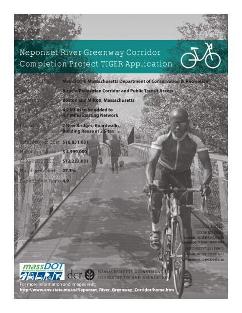
Neponset River Greenway Corridor Completion Project TIGER
Neponset River Greenway Corridor Completion Project TIGER
Neponset River Greenway Corridor Completion Project TIGER

You also want an ePaper? Increase the reach of your titles
YUMPU automatically turns print PDFs into web optimized ePapers that Google loves.
<strong>Neponset</strong> <strong>River</strong> <strong>Greenway</strong> <strong>Corridor</strong><br />
<strong>Completion</strong> <strong>Project</strong> <strong>TIGER</strong> Application<br />
Submitted by<br />
Use<br />
Location<br />
Length<br />
Features<br />
MassDOT & Massachusetts Department of Conservation & Recreation<br />
Bicycle/Pedestrian <strong>Corridor</strong> and Public Transit Access<br />
Boston and Milton, Massachusetts<br />
4.2 Miles to be added to<br />
4.7 Miles Existing Network<br />
2 New Bridges; Boardwalks;<br />
Building Reuse at 2 Sites<br />
Total <strong>Project</strong> Cost $16,831,031<br />
Matching Funds $ 4,599,000<br />
GRANT REQUEST $12,222,031<br />
Match provided 27.3%<br />
Benefit-Cost Ratio 4.9<br />
COORDINATES<br />
COLUMBIA POINT:<br />
Latitude: 42.31358349232509<br />
Longitude: 71.04650259017944<br />
NEPONSET VALLEY PKWY:<br />
Latitude: 42.23515003811633<br />
Longitude: 71.12499475479126<br />
For more information and images visit:<br />
http://www.env.state.ma.us/<strong>Neponset</strong>_<strong>River</strong>_<strong>Greenway</strong>_<strong>Corridor</strong>/home.htm
Table of Contents<br />
Site Map<br />
<strong>Project</strong> Description<br />
Transportation Challenges Addressed<br />
Segment Descriptions<br />
Segment I<br />
Segment II<br />
Segment III<br />
<strong>Project</strong> Parties<br />
<strong>Project</strong> Grant Sources and Uses<br />
Funding and Sources<br />
<strong>Project</strong> Planning and Support<br />
<strong>TIGER</strong> Criteria Applied<br />
a. Long-term Outcomes<br />
i. State of Good Repair<br />
ii. Economic Competitiveness<br />
iii. Livability<br />
iv. Environmental Sustainability<br />
v. Safety<br />
b. Job Creation and Near-Term Economic Activity<br />
c. Innovation<br />
d. Partnership<br />
e. Benefit Cost Analysis<br />
<strong>Project</strong> Readiness and NEPA<br />
Federal Wage Certification<br />
Application Changes<br />
Contact Information<br />
List of Appendices<br />
Massachusetts DCR Commissioner Letter<br />
MassDOT Federal Wage Rate Certification<br />
3<br />
4<br />
4<br />
8<br />
8<br />
9<br />
10<br />
11<br />
13<br />
13<br />
13<br />
14<br />
14<br />
14<br />
15<br />
18<br />
20<br />
20<br />
22<br />
23<br />
24<br />
25<br />
28<br />
28<br />
28<br />
28<br />
28<br />
29<br />
30<br />
Figure 1. The proposed <strong>Neponset</strong> <strong>River</strong> <strong>Corridor</strong> <strong>Completion</strong> <strong>Project</strong> connects urban neighborhoods with existing rail lines, bikeways,<br />
commercial destinations, and the river, such as here at Central Avenue.<br />
NEPONSET RIVER GREENWAY CORRIDOR<br />
2<br />
http://www.env.state.ma.us/<strong>Neponset</strong>_<strong>River</strong>_<strong>Greenway</strong>_<strong>Corridor</strong>/home.htm
Blue Hills Pkwy<br />
T<br />
T<br />
T<br />
T<br />
Blue Hills Ave<br />
BROOKLINE<br />
T<br />
T<br />
T<br />
T<br />
T<br />
Hyde<br />
Park<br />
T<br />
T<br />
DEDHAM<br />
T<br />
T<br />
Data Source: MassGIS (http://www.mass.gov/mgis/) and Google Maps<br />
T<br />
T<br />
T T<br />
T<br />
T<br />
T<br />
T<br />
T<br />
T<br />
BOSTON<br />
T<br />
T<br />
T<br />
T TT<br />
T<br />
T<br />
T<br />
T<br />
T<br />
T<br />
Dorchester<br />
T<br />
T<br />
T<br />
T<br />
T<br />
Mattapan<br />
T<br />
T<br />
T<br />
T<br />
T T<br />
T<br />
ONE-MILE<br />
CYCLING ZONE<br />
MILTON<br />
THREE-MILE<br />
CYCLING ZONE<br />
T<br />
T<br />
Columbia<br />
Point<br />
T<br />
T<br />
QUINCY<br />
T<br />
Southeast Expwy<br />
NEPONSET RIVER CORRIDOR<br />
LEGEND<br />
Bike Routes<br />
<strong>Neponset</strong> <strong>River</strong> <strong>Corridor</strong><br />
Major Bike Routes<br />
<strong>Project</strong> Segments<br />
Subway<br />
Commuter Rail<br />
MBTA Stations<br />
T Existing T Proposed<br />
Major Roads<br />
Water Bodies<br />
0 0.25 0.5 0.75 1 Miles<br />
N<br />
I-93<br />
Franklin<br />
<strong>River</strong> Street<br />
SEGMENT III<br />
TRAIL: Dorchester Bay<br />
SEGMENT II<br />
TRAIL: Central Avenue<br />
to Mattapan Square<br />
Arn nold<br />
Arboretum<br />
SEGMENT I<br />
TRAIL: Wakefield Ave<br />
to <strong>Neponset</strong> Valley Pkwy<br />
BUILDINGS: Brush Hill Road<br />
+ Demo at Mattapan Square<br />
Mattapan a<br />
Square<br />
Blue Hills<br />
Reserv<br />
rvation<br />
Innovation District<br />
JFK Presidential Library<br />
UMass s Boston<br />
BOSTON<br />
O<br />
HARBOR<br />
<strong>Neponset</strong><br />
Valley<br />
Pkwy<br />
Figure 2. <strong>Neponset</strong> <strong>River</strong> <strong>Corridor</strong> <strong>Project</strong> Area and Segments.<br />
NEPONSET RIVER GREENWAY CORRIDOR<br />
3<br />
http://www.env.state.ma.us/<strong>Neponset</strong>_<strong>River</strong>_<strong>Greenway</strong>_<strong>Corridor</strong>/home.htm
I. <strong>Project</strong> Description<br />
Build 3 segments to complete a 9-mile Bicycle and Pedestrian Network across Greater Boston. The grant<br />
amount sought is $12,222,031, which is 72.7% of the estimated total cost of $16,831,031.<br />
The <strong>Neponset</strong> <strong>Greenway</strong> <strong>Corridor</strong> <strong>Completion</strong> <strong>Project</strong> (the<br />
CORRIDOR USAGE<br />
“<strong>Project</strong>”) will create a bicycle and pedestrian route to transit, jobs,<br />
(cyclists, walkers & runners)<br />
higher education institutions and cultural resources in Boston,<br />
Existing 10, 400<br />
Massachusetts. It runs through environmental justice neighborhoods<br />
<strong>Project</strong>ed* 24,000<br />
in Boston, such as Dorchester and Mattapan, to complete a 9-mile<br />
bicycle and pedestrian system that links urban and suburban<br />
*After completion of proposed <strong>Project</strong>.<br />
communities between the Blue Hills Reservation and Boston Harbor.<br />
It will incorporate an already heavily used (but currently fragmented)<br />
bicycle/pedestrian network in the Boston area and complete a priority segment of the state’s Bay<br />
State <strong>Greenway</strong> as proposed in the Massachusett’s 2008 Bicycle Transportation Plan. The completed<br />
network will make bicycle and pedestrian travel safer by creating off-road segments and bridges that<br />
take walkers and riders past expressway ramps and over trolley tracks.<br />
Already hosting some 10,400 riders, walkers, and runners each day, the completed <strong>Corridor</strong> is<br />
expected to see usage effectively double. Of the more than 24,000 trips that would be made on it<br />
daily, an estimated 48% would be commuters, using the network to reach the job centers in Boston’s<br />
new Innovation District and its traditional Downtown. Many would use the system to access the<br />
transit lines with which the <strong>Project</strong> will connect. Approximately thirty percent of all trips (7,100) would<br />
be by bicycle, including 2,800 on just the <strong>TIGER</strong> funded segments.<br />
The <strong>Project</strong> includes three (3) segments: two existing sections that will be lengthened and improved<br />
for safety and a new middle section to connect the existing segments, thereby “filling the gap”,<br />
leveraging investments that have already been made with federal, state and local funds, and<br />
significantly improving safety for those who wish to walk or bike through this <strong>Corridor</strong>.<br />
a. Transportation Challenges Addressed:<br />
The <strong>Project</strong> will increase safe bicycle and pedestrian travel,<br />
while also making transit access easier. It will provide benefits<br />
nearly 5 times larger than its costs. Approximately 60% of the<br />
new users will be commuters. Other benefits will come from<br />
health impacts, job creation or increased property values.<br />
The completed corridor will follow the <strong>Neponset</strong> <strong>River</strong> as it<br />
runs through dense urban neighborhoods. It will provide<br />
those neighborhoods with safe and healthy transportation<br />
options for commuting to Boston’s employment and<br />
Figure 3. Columbia Point includes UMass Boston and<br />
the JFK Presidential Library.<br />
NEPONSET RIVER GREENWAY CORRIDOR<br />
4<br />
http://www.env.state.ma.us/<strong>Neponset</strong>_<strong>River</strong>_<strong>Greenway</strong>_<strong>Corridor</strong>/home.htm
educational centers, as well as nearby recreational resources. The <strong>Project</strong> will link environmental<br />
justice neighborhoods (such as Dorchester and Mattapan) in Boston with suburban neighborhoods in<br />
Milton and with the University of Massachusetts’ Boston Harbor Campus (UMass Boston), the John F.<br />
Kennedy Library and Boston’s fast growing Innovation District. The completed corridor will run from<br />
Boston Harbor in the north to the Blue Hills Reservation in the south, and eventually by way of the Bay<br />
State <strong>Greenway</strong> as far south as Cape Cod.<br />
The expanded <strong>Corridor</strong> will connect to a number of transit stations (both trolley/light rail and<br />
commuter rail). There are six (6) stations within 1/4 mile and eleven (11) within 1/2 mile. The entire<br />
corridor is within one mile of at least one rail transit station. Most of these transit stations have<br />
no parking and must be reached by walking or bicycling along city streets or parts of the already<br />
completed corridor. In fact, the new “middle” section will go right through the terminus station of<br />
BROOKLINE<br />
I-93<br />
South<br />
Boston<br />
Castle<br />
Island<br />
Allendale<br />
Woods<br />
BOSTON<br />
C<br />
Point<br />
BOSTON<br />
HARBORR<br />
Arnold<br />
Dorchester<br />
Blue Hills Ave<br />
Mattapan<br />
<strong>River</strong> Street<br />
QUINCY<br />
I-93<br />
NEPONSET RIVER CORRIDOR<br />
Blue Hills Pkwy<br />
DEDHAM<br />
Hyde<br />
Park<br />
<strong>Neponset</strong><br />
Valley Pkwy<br />
ONE-MILE<br />
CYCLING ZONE<br />
MILTON<br />
LEGEND<br />
Bike Routes<br />
<strong>Neponset</strong> Trail<br />
Existing Connection<br />
Future Connection<br />
Subway<br />
Commuter Rail<br />
MBTA Stations<br />
Existing Proposed<br />
Major Roads<br />
Data Source: MassGIS (http://www.mass.gov/mgis/) and Google Maps<br />
Blue Hills<br />
Reservation<br />
Figure 4. Regional Context in the Greater Boston Metropolitan Area.<br />
Water Bodies<br />
0 0.25 0.5 0.75 1<br />
Miles<br />
N<br />
NEPONSET RIVER GREENWAY CORRIDOR<br />
5<br />
http://www.env.state.ma.us/<strong>Neponset</strong>_<strong>River</strong>_<strong>Greenway</strong>_<strong>Corridor</strong>/home.htm
the Massachusetts Bay Transportation Authority’s (MBTA’s) Mattapan High Speed Trolley Line and is<br />
being built on land donated by the MBTA. (See Figure 4 showing the relationship between the <strong>Project</strong><br />
<strong>Corridor</strong> and Greater Boston Area.)<br />
As further detailed in following sections, some<br />
WHAT IS DIFFERENT<br />
This project applied unsuccessfully for<br />
<strong>TIGER</strong> funds last year. The main<br />
differences in this application are:<br />
20,800 bicyclists and walkers, including some 6,000<br />
commuters (47.7% of the total), will use the <strong>Project</strong>.<br />
This estimate is based on surveys of current <strong>Neponset</strong><br />
usage, use patterns for similar facilities in the Boston<br />
•<br />
•<br />
•<br />
•<br />
•<br />
MassDOT is the lead applicant.<br />
Total project cost has been slightly<br />
reduced as work has continued.<br />
Match increased and includes<br />
greater participation by the major<br />
transportation agencies.<br />
More information on safety<br />
improvements<br />
More information on commuting and<br />
travel to job centers<br />
area, and guidelines for bicycle and pedestrian systems,<br />
particularly those that feed transit. While this <strong>Project</strong><br />
is largely off-road, it will link to a network of city<br />
sponsored on-road bicycle routes (65 miles within<br />
a 1 mile radius). These feeder systems, as well as the<br />
<strong>Project</strong>’s access to 11 transit stations, will dramatically<br />
increase the non-motorized options available to the<br />
<strong>Project</strong>’s host communities, both the underserved<br />
environmental justice neighborhoods of Boston and the<br />
adjoining suburban neighborhoods of Milton.<br />
• Higher Benefit Cost ratio.<br />
Other off-road shared use paths in the Boston area<br />
demonstrate a pattern of heavy usage, particularly by<br />
commuters. Two routes generally comparable to the<br />
proposed 9 mile <strong>Neponset</strong> system – the 11 mile Minuteman Bikeway and the 4.7 mile South West<br />
<strong>Corridor</strong> trail – have Markedly heavier weekday peak hour usage than weekend usage (45% higher<br />
on the Minuteman; 31% higher on the Southwest <strong>Corridor</strong>). This pattern of increased commuter<br />
usage can reasonably be expected for the <strong>Neponset</strong> too and may well lead to the 48% estimate being<br />
exceeded.<br />
The <strong>Project</strong> will not only make the bicycle and pedestrian system more complete, but also safer. The<br />
<strong>Project</strong> will provide 4.2 miles of new off-road bike path, a change that - by itself - could reduce bicycle<br />
accidents by 37%. Beyond directing more riders on to off-road segments, the <strong>Project</strong> will:<br />
• Effectively overcome the barrier posed in Dorchester by a highway ramp from I-93 and<br />
dangerous access roads, thereby creating a safe new bicycle and pedestrian link to UMass<br />
Boston and to the jobs in Boston’s growing Innovation District<br />
• Build a pedestrian bridge over transit tracks to deter unsafe pedestrian crossings over the<br />
Mattapan High Speed Trolley Line<br />
NEPONSET RIVER GREENWAY CORRIDOR<br />
6<br />
http://www.env.state.ma.us/<strong>Neponset</strong>_<strong>River</strong>_<strong>Greenway</strong>_<strong>Corridor</strong>/home.htm
• Provide safe and attractive off-road access directly into a<br />
transit terminal near Mattapan Square<br />
• Route pedestrians and bicyclists away from the dangerous<br />
five-way commercial intersection (with narrow sidewalks<br />
and travel lanes, sidewalks, and often blocked with trucks<br />
unloading merchandise) of Mattapan Square, and;<br />
• Improve signage and provide crosswalks in high traffic<br />
areas<br />
Figure 5. Mattapan Square is an unsafe<br />
environment for cyclists. the five way<br />
intersection is too busy to incorporate<br />
signaling and signage.<br />
These changes will enhance safety for the estimated 13,600 new<br />
users, as well as those who use it now.<br />
This <strong>Project</strong> does not simply add additional miles. It leverages existing investments and community<br />
building by filling in gaps and extending the <strong>Corridor</strong> to link diverse neighborhoods and open new<br />
opportunities.<br />
This <strong>Project</strong> will build on other state and local efforts to make safe and healthy travel a hallmark of<br />
neighborhood accessibility in the Boston area:<br />
• The <strong>Neponset</strong> <strong>Greenway</strong> is one of 16 priority sections in the Bay State <strong>Greenway</strong> (BSG) that<br />
Massachusetts identified in the 2008 State Bicycle Transportation Plan. The priority sections<br />
include 100 miles of the 740 miles in the BSG. The priority sections were selected because they<br />
will create “additional connections to urban centers, extending existing paths, and maximizing<br />
the transportation utility of the network.” The <strong>Neponset</strong> <strong>Greenway</strong> is the only priority section<br />
in Boston.<br />
• The <strong>Project</strong> will advance the goals of the Commonwealth’s Healthy Transportation Compact,<br />
which was created as part of statewide transportation reform legislation and which includes<br />
the Massachusetts Secretaries of Transportation, Health and Human Services, and Environment<br />
and Energy, as well as the Highway Administrator, Transit Administrator and the Commissioner<br />
of Public Health. The Compact’s overall mission includes “reducing greenhouse gas emissions,<br />
improving access to services for persons with mobility limitations and increasing opportunities<br />
for physical activities”. The Compact adopted as a specific goal “increasing bicycle and<br />
pedestrian travel and facilitating implementation of the Bay State <strong>Greenway</strong> Network.”<br />
• Boston is becoming one of the most bike friendly cities in the nation. The City’s bike share<br />
program that began last summer (which received an earlier $3 million FTA Livability grant)<br />
hit its 100,000-trip target in half the time it took in Denver and Minneapolis. With the Mayor’s<br />
dedication to being a “bicycle friendly” city, Boston won a Silver Medal from the League of<br />
American Bicyclists in its first application. Based on the growing interest in cycling and the<br />
improvements to the bike network, HubWay, the local bikeshare program, is expanding to<br />
three new communities this year.<br />
NEPONSET RIVER GREENWAY CORRIDOR<br />
7<br />
http://www.env.state.ma.us/<strong>Neponset</strong>_<strong>River</strong>_<strong>Greenway</strong>_<strong>Corridor</strong>/home.htm
• The MBTA has invested in making it easy for bicyclists to take transit, thereby providing a low<br />
cost convenience that increases usage of both modes. In addition to its direct contribution to<br />
this project of land, signage and bike racks, the MBTA has added the following to the transit<br />
system:<br />
– Over 4,000 bike racks, with another 1,200 to come in 2012,<br />
– New secure bike parking facilities at stations throughout the system,<br />
– Bike racks on 95% of buses by 2012, and<br />
– New neighborhood maps to improve bicycle and pedestrian access to and from transit.<br />
• The <strong>Neponset</strong> <strong>Corridor</strong> will leverage or add to new investments. The <strong>Corridor</strong> along with a<br />
proposed cycle track on Blue Hill Avenue and a new Blue Hill Transit Station, will open up new<br />
transportation options and shorten travel time to downtown Boston and Rhode Island. More<br />
residents will be able to readily access these new commuting options.<br />
• Programs sponsored by groups such as the Mattapan Food and Fitness Coalition and the<br />
<strong>Neponset</strong> <strong>River</strong> <strong>Greenway</strong> Council are connecting urban gardens, farmers markets, and multiuse<br />
paths to encourage healthy habits in diverse neighborhoods. www.bostonnatural.org/<br />
gwyNep.htm; www.mattapanfoodandfitness.org<br />
b. Segment Descriptions<br />
The <strong>Project</strong> can be implemented rapidly. It will be built in three (3) segments; construction of the<br />
first part can be advertised within weeks of final grant award; construction of the second and third<br />
segments could begin in March and June of 2013 respectively. The <strong>Project</strong> would be fully operational<br />
by June 2014, although the first segment could be ready for use by the middle of 2013. The different<br />
parts and highlights of the <strong>Project</strong> are described briefly below and illustrated in Figure 2.<br />
SEGMENT I<br />
This is the southernmost of the three <strong>Project</strong> segments and will be the first built. Its cost to complete<br />
is $1,873,719. Part of the overmatch will be met by a $200,000 donation from the Stop & Shop<br />
Supermarket Company.<br />
This will create a 0.5-mile off-street route for<br />
bicyclists (as well as pedestrians) and improve<br />
0.45 miles of on-street routes for cyclists. It will<br />
increase safety by providing an off-road option<br />
for bicyclists who now must share the road in a<br />
high traffic area. This segment passes through<br />
the Mattapan Square Station and lies within<br />
1/4 mile of the MBTA’s Fairmount Station on<br />
Figures 6a and 6b: Current Condition (top); Proposed Multi-Use<br />
Path (bottom) along Truman Parkway at the southern end of the<br />
<strong>Corridor</strong><br />
NEPONSET RIVER GREENWAY CORRIDOR<br />
8<br />
http://www.env.state.ma.us/<strong>Neponset</strong>_<strong>River</strong>_<strong>Greenway</strong>_<strong>Corridor</strong>/home.htm
the Fairmount Commuter Rail Line. Residents of<br />
suburban Milton and of Boston’s Mattapan and<br />
Hyde Park neighborhoods will be able to bike<br />
to commuter rail or to the trolley line when this<br />
is built. Approximately 450,000 people live in<br />
neighborhoods within 3 miles of the path, the<br />
distance deemed reasonable by FTA’s guidelines for<br />
bikeways that provide access to transit.<br />
Martini Shell Park<br />
Stop & Shop Supermarket<br />
<strong>Project</strong> <strong>Corridor</strong><br />
This segment features the renovation of an<br />
existing building in Milton that will serve as the<br />
bikeway’s public information/education center.<br />
A small commercial building (vacant for years<br />
and purchased by DCR) located adjacent to the<br />
Mattapan Square Transit Stop will be renovated and<br />
offered for supportive retail use, such as bike repair.<br />
truman parkway<br />
<strong>Neponset</strong> <strong>River</strong><br />
Neposnet Valley Pkwy<br />
Running from a point near the Mattapan/Milton<br />
100 400 ft<br />
border, this segment will not only provide improved 0 200<br />
commuter access on two MBTA transit lines, but will Figure 7. Segment I Plan<br />
also take riders and walkers along the <strong>Neponset</strong><br />
<strong>River</strong> and to the edge of DCR’s Blue Hill Reservation,<br />
a 7,000 acre conservation area with 125 miles of trails - the largest open space within thirty-five miles<br />
of Boston.<br />
to the Blue Hills<br />
Reservation<br />
Segment I will be ready to go within weeks of the final grant award.<br />
SEGMENT II<br />
This is the middle segment and will be the second built. It will cost $9,786,623. The overmatch will<br />
incorporate right of way donated by the MBTA.<br />
This segment will be 1.5 miles long and include two (2) bridges and a cantilevered boardwalk. It also<br />
will provide a safe off-road route for bicyclists and pedestrians. Incorporating the path of a former<br />
railroad bed, it will provide access to transit as it follows and crosses the <strong>Neponset</strong> <strong>River</strong>. Among the<br />
features will be a “canopy walk” that will allow safe bicycle and pedestrian passage over the existing<br />
Mattapan trolley line, as well as a bridge that will allow bicyclists and pedestrians to cross over the<br />
<strong>Neponset</strong> <strong>River</strong>. The construction costs for the Canopy Walk and the river bridge are estimated to be<br />
$4,223,940 and $1,212,750 respectively.<br />
NEPONSET RIVER GREENWAY CORRIDOR<br />
9<br />
http://www.env.state.ma.us/<strong>Neponset</strong>_<strong>River</strong>_<strong>Greenway</strong>_<strong>Corridor</strong>/home.htm
Mattapan Square Heavy Traffic<br />
Existing Bike Route<br />
Mattapan Square Entry Plaza<br />
Mattapan Station<br />
Existing Bike Path Along Narrow and Busy <strong>River</strong> Street<br />
Central Ave<br />
Ryan Playground<br />
Station<br />
BOSTON<br />
Central Ave<br />
T<br />
neponset river<br />
T<br />
MILTON<br />
<strong>Project</strong><br />
<strong>Corridor</strong><br />
Blue Hills Ave<br />
T<br />
T<br />
Capen Street<br />
Station<br />
Rail Crossing<br />
(CanopyWalk)<br />
<strong>River</strong><br />
Crossing<br />
Valley<br />
Station<br />
100 400ft<br />
0 200<br />
Figure 8: Segment II Plan showing the proposed trail along the river and the existing trail in red alond the narrow and busy <strong>River</strong> Street<br />
This segment will provide a connection between Mattapan, an environmental justice neighborhood<br />
in Boston, and Milton, the adjoining suburb that CNN ranks as one of the nation’s best places to live<br />
in the United States. The <strong>Project</strong> will provide both areas with safe and healthy access to Boston’s job<br />
centers and educational opportunities, as well as the recreational resources at either end of the full<br />
corridor (i.e., Boston Harbor to the north and the Blue Hills reservation to the south). It will improve<br />
access to the transit system and businesses in Mattapan Square.<br />
Figures 9a, 9b: The existing path along <strong>River</strong> Street is neither safe for cyclists nor does the road have space to accomodate bike<br />
facilities (l) The <strong>Project</strong> proposes to install a 10-foot-wide multi-use trail that connects to a proposed river-crossing. The rendering<br />
is showing the proposed trail at the Central Ave T Station (r).<br />
Construction of this segment can begin in March 2013 and be completed by June 2014.<br />
SEGMENT III<br />
This northernmost section of the <strong>Project</strong> will be the third to be built. It will cost $5,170,689. A portion<br />
of the match will be provided by right-of-way donations from National Grid and from MassDOT as well<br />
as a cash contribution from MassDOT.<br />
This segment will be 1.75 miles long and will provide a safe off-street route for bicyclists and<br />
pedestrians. It will allow bicyclists and pedestrians to pass under the Southeast Expressway (I-93S),<br />
NEPONSET RIVER GREENWAY CORRIDOR<br />
10<br />
http://www.env.state.ma.us/<strong>Neponset</strong>_<strong>River</strong>_<strong>Greenway</strong>_<strong>Corridor</strong>/home.htm
emain off-road, avoid the narrow (with no sidewalk)<br />
and dangerous access road to Morrissey Boulevard, and<br />
safely reach a major transfer point of the MBTA’s Red<br />
Line Subway. This segment will also lead to Boston’s<br />
Harbor Walk near the UMass Boston campus. The Harbor<br />
Walk provides public access from UMass Boston to the<br />
“Innovation District” on South Boston’s waterfront and<br />
then to downtown Boston. Both are prime job centers.<br />
UMass Boston is a public university with over 15,000<br />
students. It is adjacent to the JFK Library and Museum<br />
that attracts visitors from around the world.<br />
Southeast Expwy<br />
Victory Rd<br />
to Harbor<br />
Walk<br />
National<br />
Grid Property<br />
<strong>Project</strong><br />
<strong>Corridor</strong><br />
BOSTON<br />
HARBOR<br />
boardwalk<br />
Morrissey Blvd<br />
This segment will adjoin an innovative 4,460 panel solar<br />
power project that National Grid is building at a cost<br />
of $9.4 million; the <strong>Project</strong> will include an interpretive<br />
exhibit to educate <strong>Corridor</strong> users about solar power.<br />
The <strong>Project</strong> also will improve the connection to a major<br />
recreation facility (Pope John Paul II Park) that was built<br />
by DCR on a former landfill. This segment will include an<br />
elevated boardwalk to facilitate coastal access and bypass<br />
the exit ramp to I-93.<br />
Victory<br />
Park<br />
NEPONSET<br />
RIVER<br />
<strong>Project</strong><br />
<strong>Corridor</strong><br />
100 400 ft<br />
0 200<br />
Figure 10: Segment III Plan showing the existing trail in red<br />
The construction of this segment can begin by June 1, 2013 and be completed by April 2014.<br />
All funding will be obligated prior to June 30, 2013. Further schedule details are provided in Table B.<br />
The proposed project schedule is set out in Table A. It reflects MassDOT’s and DCR’s commitment to<br />
timely obligation of funds and to prompt project delivery.<br />
Figures 11a and 11b (l to r): Existing bike way on a road with no shoulder; proposed boardwalk connection.<br />
II. <strong>Project</strong> Parties<br />
The <strong>Project</strong> applicants are the Massachusetts Department of Conservation and Recreation (DCR)<br />
and the Massachusetts Department of Transportation (MassDOT). MassDOT, the lead applicant,<br />
NEPONSET RIVER GREENWAY CORRIDOR<br />
11<br />
http://www.env.state.ma.us/<strong>Neponset</strong>_<strong>River</strong>_<strong>Greenway</strong>_<strong>Corridor</strong>/home.htm
TABLE A<br />
<strong>Neponset</strong> <strong>Greenway</strong> <strong>Project</strong><br />
Schedule<br />
YEAR 2012<br />
2013<br />
2014<br />
Quarter 1 2 3 4 1 2 3 4 1 2 3 4<br />
PROJECT SCHEDULE<br />
Segment 1<br />
Design<br />
Building Demolition Plans (design complete)<br />
Blue Hill Avenue connection<br />
7 Brush Hill Road (design complete)<br />
Stop & Shop to <strong>Neponset</strong> Park (complete by<br />
March 1, 2012)<br />
Bidding<br />
Construction<br />
Segment 1 Complete<br />
01-Jul-12<br />
15-Aug-12<br />
30-Jun-13<br />
Segment 2<br />
Design and Permitting<br />
Central Avenue to Blue Hill Avenue<br />
Bidding<br />
Construction<br />
Segment 2 Complete<br />
Segment 3<br />
Design and Permitting<br />
Dorchester Bay<br />
1-Feb-13<br />
01-Feb-13<br />
15-March-13<br />
15-Apr-13<br />
30-Jun-14<br />
Bidding<br />
Construction<br />
Segment 3 Complete<br />
15-Apr-13<br />
01-Jun-13<br />
30-Apr-14<br />
is the newly created state agency that combines disparate highway, transit, and aviation agencies<br />
into a single entity with responsibility for all modes of transportation across Massachusetts. DCR,<br />
the partnering agency, is the state agency in charge of state parks, parkways, trails, dams, and other<br />
natural resources such as state forests. Both MassDOT and DCR are established federal grantees and<br />
they collaborate on projects ranging from bike paths to bridges.<br />
DCR is the owner of the existing <strong>Neponset</strong> <strong>Greenway</strong> bicycle and pedestrian network, in which it<br />
has already invested $7 million (including the recent renovation of a former railroad bridge linking<br />
Adams Village in Boston to the <strong>Neponset</strong> <strong>River</strong> <strong>Greenway</strong> in Milton). DCR is contributing $3,052,000 in<br />
match and will own and maintain the completed system. MassDOT, the MBTA, and two private sector<br />
partners (the National Grid utility company and Stop & Shop grocery) will donate the balance of the<br />
27.3% match.<br />
MassDOT and DCR have built several successful bicycle and pedestrian projects. DCR also has<br />
considerable experience maintaining bicycle and pedestrian projects; it is responsible for 184 miles of<br />
paved bike trails throughout Massachusetts, including a 16-mile bike path along the Charles <strong>River</strong> and<br />
the Southwest <strong>Corridor</strong> multi-use path that was built in a former transit right of way through Boston.<br />
NEPONSET RIVER GREENWAY CORRIDOR<br />
12<br />
http://www.env.state.ma.us/<strong>Neponset</strong>_<strong>River</strong>_<strong>Greenway</strong>_<strong>Corridor</strong>/home.htm
III. <strong>Project</strong> Grant Sources and Uses: Funds and Planning Support<br />
a. Funding sources: The <strong>Project</strong> brings a 27.3% match. The match reflects the public-private and<br />
public-public partnerships that support the project.<br />
The cost of completing the corridor is $16,831,031; the amount of <strong>TIGER</strong> funding requested is<br />
$12,222,031. The 27.3% overmatch will come from 5 separate sources:<br />
• Massachusetts Department of Conservation and Recreation (<strong>Project</strong> owner and co-applicant,<br />
$3,052,000 in state funds)<br />
• Massachusetts Department of Transportation (<strong>Project</strong> co-applicant) ($300,000 in state funds<br />
and $291,500 right of way donation)<br />
• Massachusetts Bay Transportation Authority ($352, 500 right of way donation plus $25,000 for<br />
signage and bike racks near stations )<br />
• National Grid ($378,000 right of way donation)<br />
• Stop & Shop Supermarket Company ($200,000 private funds)<br />
<strong>Project</strong> costs have been carefully estimated and contingencies included, but MassDOT and DCR<br />
understand and acknowledge that they would be responsible for any additional project costs should<br />
they be necessary.<br />
These funds would be used for the three segments as detailed in the budget in Table B:<br />
TABLE B: <strong>Project</strong> Costs<br />
*<strong>Project</strong> Costs are based on previous planning and preliminary design and engineering.<br />
<strong>TIGER</strong> Match TOTAL<br />
TOTAL PROJECT $ 12,222,031 $ 4,599,000 $ 16,831,031<br />
Segment I $1,273,118 $600,601 $1,873,719<br />
Segment II $7,783,050 $2,003,574 $9,786,623<br />
Segment III $3,165,863 $1,994,825 $5,170,689<br />
b. <strong>Project</strong> Planning and Support<br />
The <strong>Project</strong> shares the strong support of Federal, state and local elected officials from both host<br />
communities as well as a variety of local and regional advocacy groups dedicated to improving<br />
sustainable transportation, healthy living, environmental justice and protection of our natural<br />
resources. The <strong>Corridor</strong>’s design is the product of a multi-year process. DCR has engaged the<br />
community, developed master plans, and added features to incorporate the needs of the community<br />
into the goals of the <strong>Project</strong>. The City of Boston has incorporated the proposed <strong>Project</strong> in its economic<br />
plan for the central host neighborhood.<br />
NEPONSET RIVER GREENWAY CORRIDOR<br />
13<br />
http://www.env.state.ma.us/<strong>Neponset</strong>_<strong>River</strong>_<strong>Greenway</strong>_<strong>Corridor</strong>/home.htm
The <strong>Project</strong> is also a priority of the 2008 Massachusetts Bicycle Plan issued by MassDOT. The Plan<br />
identified 100 miles within the 740 mile Bay State <strong>Greenway</strong> as the key first steps towards a cohesive<br />
statewide bicycle network (the BSG 100). The <strong>Neponset</strong> <strong>Greenway</strong> is part of these priority projects for<br />
the state and is the only one to be built within Boston.<br />
The State Bike Plan represents the Governor’s commitment to a modern transportation network that<br />
balances all modes, including increased availability of bicycle and pedestrian options. As the Plan<br />
stated:<br />
“Consistent with Governor Deval Patrick’s Sustainable Development Principles, by 2030 Massachusetts will<br />
be a leading state in sustainable transportation and development. Our transportation system will better<br />
balance transportation modes, offering Commonwealth citizens and visitors alike a network of roads,<br />
shared use paths, and transit facilities designed, constructed, and maintained with bicycle use always in<br />
mind. Our bicycle transportation network will feature 50 percent more miles of designated facilities than<br />
exist now and comprise both on‐ and off‐road resources.”<br />
This project will also advance the goals of the Commonwealth’s Healthy Transportation Compact,<br />
formed so that the most senior leaders in the state are focused on “adopt[ing] best practices to<br />
increase efficiency to achieve positive health outcomes through the coordination of land use,<br />
transportation and health policy.” This collaboration emphasizes the Commonwealth’s commitment<br />
to making smart transportation choices that create access to employment, education and recreation<br />
while reducing greenhouse gases and promoting physical activities. Among the Compact’s top<br />
priorities is “Increasing bicycle and pedestrian travel and facilitating implementation of the Bay State<br />
<strong>Greenway</strong> Network”, within which the <strong>Neponset</strong> <strong>Greenway</strong> is a priority project.<br />
IV. <strong>TIGER</strong> Selection Criteria Applied<br />
This <strong>Project</strong> fulfills all the criteria required for <strong>TIGER</strong> funding. It will create benefits almost five (5)<br />
times its costs. Its route, design, and local match reflect a goal shared among several stakeholders. If<br />
awarded a <strong>TIGER</strong> grant, this <strong>Project</strong> will enhance the livability of several diverse neighborhoods while<br />
creating a safe and healthy travel option for Greater Boston.<br />
A. LONG-TERM OUTCOMES<br />
i. State of Good Repair<br />
The <strong>Project</strong> will complete and improve a bicycle and pedestrian corridor that weaves through<br />
developed urban and suburban areas. By removing bicycle traffic from busy city streets and making<br />
better use of underutilized rights of way, it will make healthy transportation safer and more appealing.<br />
NEPONSET RIVER GREENWAY CORRIDOR<br />
14<br />
http://www.env.state.ma.us/<strong>Neponset</strong>_<strong>River</strong>_<strong>Greenway</strong>_<strong>Corridor</strong>/home.htm
Estimated increased bicycle use<br />
(described more fully in the benefit-cost<br />
analysis technical memo and based<br />
on NCHRP Report 552) will result in<br />
a reduction of auto vehicles miles of<br />
travel (VMT) that will lessen roadway<br />
deterioration and maintenance costs.<br />
MBTA TOD Parcel<br />
Connector<br />
Proposed route of <strong>Project</strong><br />
Mattapan T Station<br />
Mattapan Square<br />
DCR and MassDOT are experienced<br />
stewards of multi-use networks. DCR,<br />
as owner, will be responsible for<br />
maintenance. It has a maintenance<br />
staff of 997, supplemented by a<br />
seasonal crew of 1,700. In FY11, its combined capital and operating budget was over $150 million.<br />
In the <strong>Neponset</strong> <strong>Corridor</strong> it has expanded its available resources and built community capacity by<br />
sponsoring local groups that help with seasonal responsibilities. This includes youth conservation<br />
corps and programming of activities. If this grant is awarded, the completed <strong>Neponset</strong> <strong>Greenway</strong><br />
<strong>Corridor</strong> will be maintained by DCR’s trained workforce and established budgetary resources,<br />
supplemented by the kind of local interest that assures long-term benefits.<br />
Blue HIlls Avenue<br />
Figure 12: The <strong>Project</strong> will improve the 5 way intersection at Mattapan Square which<br />
is now hard for pedestrians and cyclists to navigate safely. Currently the intersection<br />
is unsafe with no room for cyclists.<br />
ii. Economic Competitiveness<br />
The <strong>Project</strong> will enhance the economic vitality and competitiveness of the region, particularly in the<br />
environmental justice communities that it serves.<br />
MassDOT’s 2008 Bike Plan emphasizes<br />
the importance of successful active<br />
transportation projects as part of the<br />
state’s economy. As the State Bike Plan<br />
said: “Investments in bicycle facilities<br />
have resulted in positive economic<br />
impacts in terms of tourism… and for<br />
adjacent real estate values…. Strategic<br />
investments in new bicycle facilities can<br />
lead to positive benefits and better serve<br />
the Commonwealth’s information‐based<br />
economy.“ Creating this extended multiuse<br />
path will improve the medium and<br />
long-term economic competitiveness of<br />
the region as forecast by the State Bike<br />
Plan.<br />
UMASS – AN URBAN PUBLIC UNIVERSITY<br />
UMass Boston is a large urban university that offer<br />
undergraduate and graduate programs through 8 colleges at its<br />
campus on its Boston Harbor campus.<br />
Some 15,000 students are enrolled and the student population<br />
is diverse. There is virtually no on-campus housing, so University<br />
life depends on off-campus housing in surrounding communities<br />
and low-cost transportation options (including the MBTA).<br />
The <strong>Neponset</strong> <strong>Project</strong> will not only make it easier for residents to<br />
reach the University, it will give University students and faculty<br />
better access to housing opportunities along the <strong>Neponset</strong><br />
<strong>Corridor</strong>.<br />
NEPONSET RIVER GREENWAY CORRIDOR<br />
15<br />
http://www.env.state.ma.us/<strong>Neponset</strong>_<strong>River</strong>_<strong>Greenway</strong>_<strong>Corridor</strong>/home.htm
First, this path will create low-cost access to employment centers, institutions of higher education,<br />
transit nodes and businesses up and down the <strong>Corridor</strong>. The Boston Bycyclists Union identified 107<br />
employers (a partial list of the total) within 5 city blocks of the proposed route, and almost 50,000<br />
jobs are within 1 mile of the route.<br />
TABLE C: Environmental Justice Area Demographics<br />
Location of<br />
Environmental<br />
Justice Area (EJA)<br />
Total Population<br />
of EJA<br />
Minority<br />
Population of<br />
EJA<br />
Percent of Total<br />
Population that<br />
is Minority<br />
EJA’s Median<br />
Household<br />
Income<br />
as a Percent of the<br />
Region’s Median<br />
Household Income<br />
Dorchester 53,596 42,157 79% 67%<br />
Mattapan 50,966 48,779 96% 60%<br />
Source: Journey to 2030 Transportation Plan of the Boston Region Metropolitan Planning Organization, April 2007<br />
Having a completed corridor will remove existing barriers and create new links from neighborhood<br />
retail and housing centers (e.g., Mattapan Square) all the way to the UMass/Boston campus and<br />
then on to Boston’s fast growing Innovation District. The low-cost nature of cycling allows families to<br />
allocate resources to other needs, such as housing. This is particularly important in Boston, which has a<br />
very high combined cost of housing and transportation- 56% of median household income in the City<br />
of Boston goes for housing and transportation according to the Urban Land Institute’s 2010 report,<br />
“Boston Regional Challenge”(p.10). By comparison, the combined cost of housing and transportation<br />
in Washington DC is 47% (ibid, p.1).<br />
While the <strong>Project</strong>’s economic impact will be corridor wide, Mattapan Square exemplifies the type of<br />
long-term positive outcomes that the <strong>Project</strong> can create in the environmental justice communities<br />
through which it passes.<br />
In 2004 some 90% of Mattapan’s population was African-Americans and persons of Caribbean<br />
descent. The City of Boston’s 2006 Economic Development Action Agenda for Mattapan identified<br />
the <strong>Neponset</strong> <strong>River</strong> <strong>Greenway</strong> <strong>Corridor</strong> as a beneficial project that would improve the pedestrian<br />
environment and make it easier to access a retail area that lacked parking. That report found that local<br />
retail was underdeveloped partially because it was close, but not convenient. This <strong>Project</strong> would help<br />
alleviate that problem. Improving the link to the <strong>Neponset</strong> <strong>River</strong> <strong>Greenway</strong> is one of the action items<br />
identified as a “Key Business Development Strategy” for the Mattapan business district. In addition,<br />
access to the MBTA’s soon to be developed TOD project adjacent to Mattapan Station will be enhanced<br />
by the project.<br />
The <strong>Project</strong> would also provide a healthy, safe, and convenient way for Mattapan residents to reach<br />
Boston’s job centers. While Mattapan has several transit alternatives now, non-auto travel to the major<br />
NEPONSET RIVER GREENWAY CORRIDOR<br />
16<br />
http://www.env.state.ma.us/<strong>Neponset</strong>_<strong>River</strong>_<strong>Greenway</strong>_<strong>Corridor</strong>/home.htm
job centers tends to involve transfers. This time travel penalty is illustrated in the following chart<br />
comparing the average commute times for Mattapan (Zip Code 02126) and the City of Boston:<br />
TABLE D: Commuter Travel Time, Mattapan vs. City of Boston<br />
Travel Time Mattapan Zip Code City of Boston<br />
Less than 30 Minutes 34.6% 52.3%<br />
30 - 44 Minutes 33.3% 26.6%<br />
45 - 59 Minutes 16.6% 10.7%<br />
60 or more Minutes 15.6% 8.3%<br />
Second, active transportation, such as biking, is growing as an industry in itself and a stimulus for<br />
tourism.<br />
The City of Boston reports that jobs directly attributable to the bike industry have grown by 60%<br />
over the past three years. In 2010 (even before Boston’s successful bike share program opened) there<br />
were already 350 bicycle-related jobs in Boston, including many at the seven (7) new bicycle-related<br />
businesses that opened since 2007. Bike share is not simply a nice amenity for the public; it is a<br />
growing local business that will soon spread to three new communities in the next eight months –<br />
with fundraising ongoing to make the UMass Boston Campus a bike share site too.<br />
Biking allows more communities to benefit from tourism. Tourism is one of Massachusetts’ leading<br />
industries; 20 million people visited Massachusetts in 2008 and they spent $15.6 billion. While visitors<br />
to the JFK Library would not be likely to<br />
drive to Mattapan, they might want to<br />
bike to the Blue Hills along the <strong>Neponset</strong><br />
<strong>River</strong> – stopping in Mattapan on their<br />
way. Particularly now that Boston can<br />
offer a booming bike share program,<br />
reliance on these links will increase. This<br />
will result in new jobs and increased<br />
tourism with less congestion.<br />
Figures 13a and 13b: Truman Parkway before construction (l); New work along<br />
Brush Hill Road (r) incorporates landscaped stormwater infiltration trenches,<br />
parkway guardrails and a safe route of travel adjacent to swift moving vehicles.<br />
These improvements are typical of those proposed for Segment I of the<br />
<strong>Neponset</strong> <strong>River</strong> <strong>Corridor</strong> <strong>Project</strong>.<br />
Finally, there is evidence that a<br />
completed trail will create added value<br />
for local homeowners along the corridor.<br />
A Massachusetts real estate study looked at the impact of rail trails on price and time on the market for<br />
home sales using homes near trails in Eastern Massachusetts (Minute Man Trail and the Nashua <strong>River</strong><br />
Trail). Homes near the trails both held their price (sold closer to the list price) and were on the market<br />
for less time compared to other homes. (http://www.greenway.org/pdf/ma_home_sales.pdf).<br />
NEPONSET RIVER GREENWAY CORRIDOR<br />
17<br />
http://www.env.state.ma.us/<strong>Neponset</strong>_<strong>River</strong>_<strong>Greenway</strong>_<strong>Corridor</strong>/home.htm
Consistent with these findings and<br />
national research on the property value<br />
impact of residential real estate near bike<br />
trails, we estimate a modest incremental<br />
property value premium. But when<br />
applied to the large population and<br />
number of residences near the new trail<br />
segments, this results in significant benefit<br />
estimated to be approximately $40 million<br />
(even with “netting out” transportation<br />
benefits).<br />
Building to be demolished for entrance to<br />
<strong>Greenway</strong> and for safety improvements<br />
iii. Livability<br />
Massachusetts has focused on bicycle<br />
transportation as part of the “Healthy<br />
Transportation Compact” formed by<br />
the state’s Departments of Health,<br />
Transportation, and Environment and<br />
Energy pursuant to a legislative directive<br />
that accompanied MassDOT’s creation. .<br />
. .” This <strong>Corridor</strong> <strong>Completion</strong> <strong>Project</strong> will<br />
create travel options that encourage<br />
healthier lifestyles.<br />
Figures 14a and 14b (t to b): The removal of three existing out-buildings at Mattapan<br />
Square allow for a rejuvenated transit hub that includes bike parking, new plantings,<br />
seating and improved visual access into the station’s facilities for bus drivers.<br />
The relevance of this <strong>Project</strong> to long term livability benefits is well illustrated by the Mattapan Food<br />
and Fitness Coalition, which sponsors farmers’ markets and encourages more reliance on walking<br />
and biking. That group has found that Mattapan has one of the highest rates of asthma, diabetes,<br />
and heart disease in the City and County. Right now there are few alternatives to busy roadways for<br />
bicyclists and pedestrians throughout this <strong>Corridor</strong> - a limitation that this <strong>Project</strong> will remedy.<br />
The enhanced access to transit will also reinforce the area’s best development choices. Near this<br />
<strong>Project</strong>, the MBTA has plans for a Transit Oriented Development site at Mattapan Station, that will give<br />
“strong preference to development plans that support this project. This type of development (not<br />
car centered, but relying on walkability and proximity to transit) dovetails perfectly with USDOT’s<br />
Livability Principles and with an asset such as this bikeway.<br />
Mattapan Square has already benefited from a “Main Streets” grant, but a greater pedestrian presence<br />
will increase the neighborhood’s sense of security and community. Seniors, young parents with<br />
strollers, students, and commuters use the existing bike path. This usage pattern is a form of safe and<br />
healthy travel; it allows people to come together to share a resource and their neighborhood.<br />
NEPONSET RIVER GREENWAY CORRIDOR<br />
18<br />
http://www.env.state.ma.us/<strong>Neponset</strong>_<strong>River</strong>_<strong>Greenway</strong>_<strong>Corridor</strong>/home.htm
The livability benefits of this <strong>Project</strong> can be quantified both in terms of existing and new bicyclists and<br />
pedestrians who will be using the <strong>Neponset</strong> <strong>Greenway</strong> bicycle and pedestrian system. Recent counts<br />
by the Boston Bikes volunteer organization found approximately 400 bicyclists and 2,400 pedestrians<br />
(including joggers) within a six (6) hour period on existing segments of the <strong>Greenway</strong>. Many of these<br />
users, along with new users, will benefit from the completed segments provided by this <strong>Project</strong> in<br />
terms of safety and a more pleasant trip compared to on-road. Additional users will be generated from<br />
multiple sources, including recreational users and commuters who will be able to use the completed<br />
<strong>Greenway</strong> bicycle and pedestrian system to safely access MBTA stations and jobs. As estimated below,<br />
these mobility impacts (particularly those affecting commuters) for existing and new users are the<br />
largest benefit in the benefit-cost analysis ($145 million over 30 years, undiscounted).<br />
This <strong>Project</strong> epitomizes the small choices that can make a big difference in how a community<br />
chooses to travel and to interact. A bike repair shop may not be a major job creator, but it is the type<br />
of business that the City of Boston’s Economic Development Action Agenda recommended to help<br />
bring people to Mattapan Square. Taking one’s children by bike from the new neighborhood to the<br />
old neighborhood (as described in neighborhood support letters) may be a relatively short trip, but<br />
it can help tie families and neighbors together in new ways that improve the livability of the whole<br />
community.<br />
Canopy Walk/Rail Crossing<br />
Figure 15: The canopy walk provides a safe, separated mode of travel for cyclists and pedestrians looking to use the transit system at<br />
Mattpan Station that will coordinate with the $10 million of station upgrades MBTA has completed over the last 5 years<br />
As noted in the State Bike Plan, “Our higher‐density neighborhoods are often characterized by motor<br />
vehicle congestion and parking scarcity. In these locations, parking construction costs are very high,<br />
which often makes bicycling a more competitive mode of travel”, suggesting that this is exactly<br />
the type of project in the right area to benefit from an enhanced multi-use network. As there is no<br />
(or very limited) parking at 8 of the 11 transit stops within a half mile of the corridor, most people<br />
NEPONSET RIVER GREENWAY CORRIDOR<br />
19<br />
http://www.env.state.ma.us/<strong>Neponset</strong>_<strong>River</strong>_<strong>Greenway</strong>_<strong>Corridor</strong>/home.htm
accessing the public transportation system here must currently do so by walking or bicycling. This<br />
project provides more people with a safe route to those stations.<br />
iv. Environmental Sustainability<br />
There will be several kinds of environmental benefits from this <strong>Project</strong>.<br />
First, increased use of the existing bicycle and pedestrian network and higher levels of bicycle and<br />
pedestrian activity will cause a measurable reduction in auto VMT. Combined with the improved<br />
connections to transit, this will reduce dependence on oil and gasoline consumption and reduce air<br />
pollutants, including greenhouse gas emissions.<br />
Second, in addition to the planned work, DCR will – as a matter of standard practice – remediate<br />
any noteworthy contamination it finds within the right of way. This work would be in addition to the<br />
pledged local match.<br />
Third, the completed <strong>Project</strong> will substantially benefit the surrounding natural environment. The<br />
greater access to and through wooded riverbank areas will not only mean greater public appreciation<br />
of those resources, but also more aggressive maintenance as downed trees and other problems<br />
become more visible.<br />
Fourth, during and after construction DCR will provide on an ongoing basis:<br />
• Management of forested areas<br />
• Plantings where trails impact habitat<br />
• <strong>River</strong> bank stabilization and enhanced aquatic and riparian habitat<br />
• Groundwater recharge and infiltration of storm water runoff<br />
DCR’s partnership with MassDOT will make sure that the path is<br />
not only safe and fully functional, but that it is just as attractive and<br />
protected as the natural resources that the <strong>Project</strong> will connect<br />
- the Blue Hills Reservation to the south, the beaches of Boston<br />
Harbor to the north, and neighborhood parks along the way.<br />
v. Safety<br />
A key element of this <strong>Project</strong> is the reduction in the number of<br />
conflicts that bicyclists who travel this route currently have with<br />
cars and an increase in the options for safe passage that riders and<br />
walkers will have as they negotiate around and over other modes.<br />
Figure 16: The busy Boston roads and intersections<br />
prevent many people from making the<br />
choice to ride into work. The safety of the<br />
<strong>Corridor</strong> will allow people to have a safe and<br />
healthy commute.<br />
NEPONSET RIVER GREENWAY CORRIDOR<br />
20<br />
http://www.env.state.ma.us/<strong>Neponset</strong>_<strong>River</strong>_<strong>Greenway</strong>_<strong>Corridor</strong>/home.htm
The vast majority of the new network (3.53 miles of the 4.2<br />
miles) will be off road. The <strong>Project</strong> will also improve eight (8)<br />
intersections.<br />
According to Boston’s 2010 State of the Hub Year End Report<br />
on bicycling, 37% of all bicycle crashes are with an automobile.<br />
If Boston’s trend towards greater bicycle usage (a 122%<br />
ridership increase between 2007 and 2009) is to continue<br />
safely, more riders will need off-road alternatives. To use<br />
the existing portions of the <strong>Corridor</strong>, riders are forced now<br />
to navigate neighborhood streets that are not designed to<br />
accommodate bicycles. With the completed <strong>Project</strong>, riders will avoid busy streets such as <strong>River</strong> Street<br />
and have safer crossings at major thoroughfares such as Blue Hill Avenue.<br />
Figure 17: The DCR already has installed some safe<br />
pedestrian crossings, which include signage and<br />
traffic signalization, along the trail.<br />
SAFE, SAFER, SAFEST<br />
This <strong>Project</strong> makes it safer to walk or bike along this 9 mile<br />
corridor running between Boston Harbor and the Blue Hills.<br />
• 37% of all bicycle crashes in Boston are with an<br />
automobile -this project provides 3.53 miles of new<br />
off-road connections.<br />
• The <strong>Project</strong>’s pedestrian bridge is a well located and<br />
attractive alternative that will reduce “jay-walking”<br />
across the transit tracks.<br />
• Highway ramps create barriers– the foot of an<br />
interstate ramp is no place to cross on foot or by<br />
bike. This offers a safe off-road connection.<br />
• Bicycle patrols by local police are planned in Milton<br />
– increasing neighborhood safety and security.<br />
The second segment will help bicyclists<br />
safely navigate through the congested<br />
five-way intersection in Mattapan Square<br />
and reach the nearby transit terminal. The<br />
third segment of the <strong>Project</strong>’s planned route<br />
creates a new link (using land donated<br />
by MassDOT) so that cyclists will be able<br />
avoid both the barrier now caused by a<br />
highway off-ramp and the narrow access<br />
roads at Morrissey Boulevard. This new link<br />
will make it possible for residents of the<br />
environmental justice communities along<br />
the <strong>Neponset</strong> <strong>Corridor</strong> to safely walk and<br />
bike to UMass Boston, Boston Harbor, and<br />
the City’s growing Innovation District.<br />
The design of the completed <strong>Greenway</strong><br />
prioritizes the safety of the users. One early concept could have created a potential operational<br />
conflict between users and transit. To eliminate this conflict, DCR and the community worked with<br />
the MBTA to include a new “Canopy Walk “ that will provide an attractive alternative for people who<br />
otherwise might be tempted to “jaywalk” across the trolley tracks.<br />
The <strong>Project</strong> will also offer new opportunities for community policing, particularly in Milton where the<br />
Chief of Police hopes to use the trail for officers on bicycles to patrol residential and wooded areas.<br />
NEPONSET RIVER GREENWAY CORRIDOR<br />
21<br />
http://www.env.state.ma.us/<strong>Neponset</strong>_<strong>River</strong>_<strong>Greenway</strong>_<strong>Corridor</strong>/home.htm
B. JOB CREATION AND NEAR-TERM ECONOMIC ACTIVITY<br />
TABLE E: Economic Growth by Sector<br />
<strong>Neponset</strong> <strong>Greenway</strong> <strong>Project</strong> Direct Jobs<br />
2012 2013 2014 Job Years<br />
Construction 28 67 33<br />
Engineering+Architecture 8 2 2<br />
Total 36 69 35 141<br />
Source: IMPLAN Economic impact model and HDR calculations<br />
This <strong>Project</strong> will increase employment and economic activity in the region. The short-term<br />
construction activity will provide jobs and labor income in construction, manufacturing and<br />
supporting industries.<br />
Based on the <strong>Project</strong> schedule and capital budget, the <strong>Project</strong> is estimated to involve141direct on-site<br />
job-years during the construction phase. The following table breaks down these labor requirements by<br />
construction and engineering by year.<br />
These direct on-site jobs are only those associated specifically with the construction elements of the<br />
<strong>Project</strong> improvements. They do not include the jobs that will be created when funds are spent on nonlabor<br />
items, such as materials and equipment and other sub-contractors. Based on the capital budget<br />
and using the nationally recognized IMPLAN economic impact modeling system, the total short-term<br />
job creation nationwide, including multiplier effects, is estimated to be 78 jobs in 2012, 172 jobs in<br />
2013, and 89 jobs in 2014.<br />
The economic impact analysis<br />
includes estimates of multiplier and<br />
total impacts based on the direct,<br />
indirect and induced impacts of the<br />
<strong>Project</strong> (note: right of way costs are<br />
excluded from these calculations).<br />
Direct wages are estimated at $7.4<br />
million, and with multiplier effects<br />
the total wage impact is $17.3<br />
million. The total business output<br />
(sales) impact based upon the direct<br />
$16.821 million investment in the<br />
<strong>Project</strong> is estimated to be $48.1<br />
million over the construction period.<br />
Figure 18: An 1,100-foot canopy walk would provide accessible, scenic travel over existing<br />
trolley tracks and respond to current safety guidelines for pedestrian railroad crossings.<br />
NEPONSET RIVER GREENWAY CORRIDOR<br />
22<br />
http://www.env.state.ma.us/<strong>Neponset</strong>_<strong>River</strong>_<strong>Greenway</strong>_<strong>Corridor</strong>/home.htm
The Council of Economic Advisors<br />
BOSTON’S INNOVATION DISTRICT<br />
(CEA) offers guidance on estimating<br />
the number of jobs associated with a<br />
Located in the Seaport District that sits between Boston’s<br />
government funded transportation<br />
Financial District and the residential areas of South Boston<br />
project. This guidance provides an<br />
(familiar to many as the setting for “Good Will Hunting”),<br />
estimate of one job created or saved per<br />
the Innovation District is filling old warehouse buildings<br />
$76,923 of government spending. Using<br />
with start-up companies and welcoming new offices and<br />
the CEA method and assuming an overall<br />
residential projects to former surface parking lots.<br />
<strong>Project</strong> expenditure of $16.821 million,<br />
Among the companies that are locating there are:<br />
219 jobs are estimated to be directly<br />
created by the investment.<br />
• Vertex Pharmaceuticals<br />
• Fraunhofer Center for Sustainable Energy Systems,<br />
Higher paying jobs are often more<br />
• Skyhook<br />
desirable for communities, as they<br />
• Greentown Labs<br />
generate a greater amount of additional<br />
• Novophage<br />
taxes and consumption. But lower paying<br />
wages may be beneficial for communities<br />
The Seaport Transportation Management Association<br />
with a greater proportion of unemployed<br />
(TMA), which is already busy meeting the needs of these<br />
low-skilled workers. Most of the jobs<br />
employers, is a strong supporter of the <strong>Neponset</strong> project.<br />
directly associated with the <strong>Project</strong> will<br />
The TMA knows that the employees of these firms will want<br />
be in construction-related industries.<br />
to bike, walk, and take transit. The more travel options they<br />
Construction employment may benefit<br />
have, the more the District will thrive.<br />
many individuals in these more<br />
economically disadvantaged populations,<br />
with secondary benefits to the local businesses and communities. On the recently opened Baker<br />
Square pedestrian bridge on the lower <strong>Neponset</strong> Trail, the contractor employed many skilled trades<br />
people and local residents from the construction trades that were previously unemployed.<br />
c. Innovation<br />
This <strong>Project</strong> will re-create a traditional travel corridor to meet 21st century needs. It will offer new<br />
and healthy access to the educational resources of UMass the Innovation District in which much of<br />
Boston’s high tech job growth is occurring. According to the Boston Globe, the Innovation District<br />
is Boston Mayor Menino’s initiative to develop underutilized waterfront property as a “platform of<br />
entrepreneurship focused on jobs, housing, and infrastructure”.<br />
The <strong>Project</strong> will allow DCR and MassDOT to complete the <strong>Neponset</strong>’s non-motorized network and<br />
provide a national model for older cities desiring to construct new, healthy and safe urban travel<br />
pathways.<br />
NEPONSET RIVER GREENWAY CORRIDOR<br />
23<br />
http://www.env.state.ma.us/<strong>Neponset</strong>_<strong>River</strong>_<strong>Greenway</strong>_<strong>Corridor</strong>/home.htm
The Commonwealth’s approach to designing and constructing new bicycle and pedestrian facilities,<br />
such as this <strong>Project</strong>, also highlights the success of Massachusetts’ landmark 2006 <strong>Project</strong> Development<br />
and Design Guide, which made context sensitive design the standard (rather than the exception) and<br />
which exemplifies the State’s focus on harmonizing and promoting all travel modes. These are design<br />
approaches that MassDOT and DCR are proud to share.<br />
d. Partnership<br />
This <strong>Project</strong> is being proposed by DCR and MassDOT consistent with the partnership that the two<br />
agencies have formed since Transportation Reform created MassDOT in 2009. The agencies are<br />
collaborating on a number of transportation projects throughout the Commonwealth – working<br />
together to emphasize the best qualities of each agency.<br />
This <strong>Project</strong> was also built on many years of carefully nurtured partnerships between neighborhoods,<br />
municipalities, businesses, and public agencies. Since the <strong>Project</strong> was proposed in 1995, it has been<br />
monitored and supported by the <strong>Greenway</strong> Council. That Council has encouraged public and private<br />
support for summer job programs that put neighborhood teens to work building <strong>Project</strong> features,<br />
as well as the planning exercises that gave rise to the present <strong>Project</strong> and the programming choices<br />
that have made the existing <strong>Greenway</strong> sections mainstays of<br />
neighborhood life.<br />
Figure 19: The City of Boston embarked on an<br />
ambitious bike share program called The Hubway<br />
in the summer of 2011.<br />
The <strong>Project</strong> has an overmatch that includes public and private<br />
partners. The public funding is supplemented by contributions<br />
from two large companies – the Stop & Shop Supermarket<br />
Company and National Grid. Those companies’ commitments<br />
are the result of negotiations with DCR and reflect the<br />
companies’ desire to invest in the communities where they are<br />
located.<br />
MassDOT and the MBTA are also contributing land and funds to supplement DCR’s resources. MassDOT<br />
and the MBTA worked closely with DCR on project development and will be very involved in its<br />
implementation. MassDOT will make a cash contribution and donate the right of way and will assure<br />
adherence to accepted standards. The MBTA also will contribute right of way and help make sure that<br />
walkers and bikers have easy connections to the several transit stations (six (6) within ¼ mile; eleven<br />
(11) within ½ mile) with which the network will connect.<br />
While not directly contributing funds to this <strong>Project</strong>, the City of Boston has undertaken a number of<br />
major bike initiatives in the past four years to become a leader in promoting and accommodating<br />
cycling, as well as other healthy activities. In fact, feeding into the <strong>Neponset</strong> <strong>Corridor</strong> there are several<br />
completed and planned City bicycle transportation improvement projects. This will increase use of the<br />
bicycle and pedestrian system to be built with this grant.<br />
NEPONSET RIVER GREENWAY CORRIDOR<br />
24<br />
http://www.env.state.ma.us/<strong>Neponset</strong>_<strong>River</strong>_<strong>Greenway</strong>_<strong>Corridor</strong>/home.htm
Under the leadership of Mayor Menino, who strongly supports this <strong>Project</strong>, the City has:<br />
• Added 1,500 new bike spaces and 33 miles of bike lanes,<br />
• Worked with 2,500 youth in the bike program (in 2010 alone)<br />
• Developed programs such as Roll it Forward (with a goal of collecting/repairing and<br />
distributing 1,000 bikes in Boston neighborhoods) and Bike to Market (bringing bike repair to<br />
Farmer’s Markets – mostly in low-income neighborhoods).<br />
Boston is now home to one of the most successful bike-share programs in the country. A program that<br />
was launched in July 2011 has already seen its 100,000th trip. The bike share program will be starting<br />
in the surrounding cities and towns (Brookline, Cambridge and Somerville) this Spring which will add<br />
to the success of the <strong>Project</strong> and the continued expansion of bicycling in the region.<br />
The <strong>Neponset</strong> <strong>River</strong> <strong>Greenway</strong> is an essential piece of the<br />
Boston Bicycling Network. It will provide a major lowstress<br />
connection for cyclists on the southern edge of the<br />
city, tying into many of the network’s most important<br />
streets like Blue Hill Avenue, Hyde Park Avenue, Morton<br />
Street and Washington Street.<br />
- BOSTON BIKE NETWORK MASTER PLAN<br />
In these and other ways, Boston is taking<br />
the steps necessary to promote cycling (bike<br />
share, bike lanes, donating bikes, safety<br />
summits). However, according to a recent<br />
survey, bicycle riders are most likely to ride<br />
where they have a separated path, out of<br />
traffic – which is exactly what the completed<br />
<strong>Project</strong> will provide.<br />
Elected officials for the Town of Milton have also expressed their strong support for and commitment<br />
to this <strong>Project</strong>. Milton’s support dates back to 1997 and today reflects the <strong>Project</strong> proponent’s<br />
willingness to address concerns at the local level. Some of the most challenging design issues occurred<br />
in Milton, but have been successfully addressed. Milton’s participation has been strengthened by the<br />
leadership of its Police Chief, who sees the <strong>Project</strong> as an opportunity to provide low impact/highly<br />
effective bicycle patrols.<br />
e. Results of Benefit-Cost Analysis<br />
If awarded a <strong>TIGER</strong> grant this <strong>Project</strong> would generate quantifiable benefits, estimated to exceed<br />
costs under all sensitivity tests and alternative assumptions. The approach used to estimate benefits<br />
is outlined in the Transportation Research Board’s (TRB) National Cooperative Highway Research<br />
Program (NCHRP) Report 552: Guidelines for Analysis of Investments in Bicycle Facilities and other<br />
sources. These guidelines stem from research in new bicycle facility investments that show direct<br />
benefits to users of the trails as well as indirect benefits to society. The direct user benefits include<br />
the new and existing commuter mobility benefits, recreation benefits and health benefits. Nonuser<br />
benefits derive from reduced automobile usage and include emissions reduction, congestion<br />
NEPONSET RIVER GREENWAY CORRIDOR<br />
25<br />
http://www.env.state.ma.us/<strong>Neponset</strong>_<strong>River</strong>_<strong>Greenway</strong>_<strong>Corridor</strong>/home.htm
eduction and accident reduction, as well as an increase<br />
in property values for those residential properties<br />
surrounding the trail. Additional details on benefits, data,<br />
assumptions and calculations can be found in the Benefit-<br />
Cost Analysis Technical Appendix. As shown below, the<br />
Net Present Value of this <strong>Project</strong> would be $59.4 million<br />
with a Benefit-Cost Ratio of 4.9. This is strong evidence of<br />
a project with a large estimated return on investment -<br />
importantly, with all sensitivity tests conducted, benefits<br />
always exceed costs.<br />
Figure 20: The MBTA has recently invested in installing<br />
bike racks in numerous trains on the commuter rail lines.<br />
Photo: www.cityphile.com<br />
The total capital cost in 2012 dollars for the <strong>Project</strong> is $16.831 million for the completion of 4.2 miles of<br />
bikeway trail in three segments, as well as modifications to the associated small buildings. The present<br />
value of these costs, discounted at 7%, is $15.1 million. Annual operating and maintenance (O&M)<br />
costs primarily consist of maintaining the streetscape surrounding such trails at a cost of $7,252 per<br />
mile, or a total of $25,746 per year for this <strong>Project</strong>. Over 30 years, the present value of these O&M costs<br />
is $268,566. The total present value for capital and O&M costs at a 7% discount rate is $15.1 million.<br />
A comparison of costs and benefits in total, and by <strong>Project</strong> segment, are shown in Table F below.<br />
Benefits for each segment begin to accrue as soon as it is complete. Discounted benefits exceed costs<br />
by 4.9 to 1 and generate net social welfare valued at $74.5 million (in present value). Benefits have<br />
been estimated for new and existing commuters who will benefit from the completion of the path, as<br />
well as new and existing recreational users. Of these net benefits, the largest sources of benefits are<br />
associated with livability in the form of mobility improvements for commuters and benefits to new<br />
recreational users.<br />
TABLE F: Benefit Cost Analysis Results By Segment<br />
Total Discounted<br />
Benefits ($M)<br />
Total Discounted Capital &<br />
Operating Costs ($M)<br />
Net Present Value<br />
($M)<br />
Benefit Cost<br />
Ratio<br />
Segment I $ 9.0 $ 1.7 $ 7.3 5.20<br />
Segment II $ 22.3 $ 8.7 $ 13.6 2.56<br />
Segment III $ 43.2 $ 4.6 $ 38.5 9.28<br />
TOTAL $ 74.5 $ 15.1 $ 59.4 4.93<br />
The categories of benefits considered in the analysis include direct mobility and safety benefits to<br />
existing users, both commuter and recreational, which generates a total non-discounted benefit of<br />
$104.2 million over 30 years, as well as benefits to new users, both commuter and recreational, totaling<br />
$60.1 million over 30 years. Almost 60% percent of these benefits to new users are estimated to accrue<br />
to commuter trips. New bicycle and pedestrian activity due to the <strong>Project</strong> also generates health<br />
NEPONSET RIVER GREENWAY CORRIDOR<br />
26<br />
http://www.env.state.ma.us/<strong>Neponset</strong>_<strong>River</strong>_<strong>Greenway</strong>_<strong>Corridor</strong>/home.htm
enefits estimated to be $19.1 million over 30 years. In addition, due to the increased connectivity and<br />
safety of the path, some of these new users may be diverted from using their automobiles to reach<br />
their destination, thus saving them operating costs. Indirect benefits include reduction in congestion,<br />
pavement maintenance, emissions and accidents due to fewer automobiles on the road, totaling $8.8<br />
million. The final benefit is an estimated increase in the value of residential properties surrounding the<br />
trail (over and above mobility benefits), totaling $41.6 million. These results can be seen in Table G.<br />
TABLE G: Benefit Cost Results by Category<br />
7% Discount Rate<br />
BENEFITS Millions of 2012$<br />
Benefits to Existing Commuters $ 63.3<br />
Benefits to Existing Recreational Users $ 40.9<br />
Benefits to New Commuters $ 35.9<br />
Benefits to New Recreational Users $ 24.2<br />
Accident Reduction $ 0.6<br />
Reduced Auto Use $ 8.2<br />
Health Benefits $ 19.1<br />
Property Value Premium $ 41.6<br />
TOTAL BENEFITS $ 233.8<br />
PV of Total Benefits $ 74.5<br />
COSTS<br />
Operating & Maintenance Costs $ 0.3<br />
Capital Costs $ 16.8<br />
TOTAL COSTS $ 17.1<br />
PV of Total Costs $ 15.1<br />
Net Present Value (NPV) $ 59.4<br />
Benefit-Cost Ratio (BCR) 4.9<br />
Sensitivity analyses were also performed on key parameters and assumptions. The following scenarios<br />
were examined:<br />
• Excluding pedestrian benefits to strictly follow the NCHRP Guidelines;<br />
• Alternative assumptions (lower and higher) for bicycle trip demand based on NCHRP<br />
guidance;<br />
NEPONSET RIVER GREENWAY CORRIDOR<br />
27<br />
http://www.env.state.ma.us/<strong>Neponset</strong>_<strong>River</strong>_<strong>Greenway</strong>_<strong>Corridor</strong>/home.htm
• Exclusion of property value and reduced vehicle usage; and<br />
• Using a 3% discount rate, which results in a benefit-cost ratio of 8.3.<br />
The results of these analyses yield Net Present Values ranging from $28.0 million to $187.3 million.<br />
Details of these results can be found in the Benefit-Cost Analysis Technical Appendix.<br />
V. <strong>Project</strong> Readiness and NEPA<br />
A Preliminary Determination of Eligibility for Categorical Exclusion/Checklist has been prepared<br />
to demonstrate that the proposed <strong>Project</strong> is able to satisfy the requirements of the National<br />
Environmental Policy Act (NEPA) as an Automatic Categorical Exclusion or a Programmatic Categorical<br />
Exclusion. Since NEPA is triggered only by the grant, filing will be made in conjunction with a<br />
preliminary award notice. The <strong>Project</strong> will also be added to the State Transportation Improvement<br />
Program (STIP) at that point. No permits are required for Segment I, which is anticipated to be ready<br />
for bid shortly after final grant award and which will be built by June 2013. No significant permitting<br />
issues are expected for the other segments and no unusual technological challenges are presented by<br />
this project. As noted earlier, construction of Segment II will begin in March 2013 and be completed<br />
June 2014; Segment III will start construction and will be completed by April 2014.<br />
VI. Federal Wage Rate Certification<br />
MassDOT will comply with the requirements of Subchapter IV of Chapter 31 of Title 40, USC (Federal<br />
Wage Rate requirements) as required by the FY2011 Continuing Appropriations Act. The signed<br />
certification is included as Figure 22 on Page 30.<br />
VII. Application Changes<br />
There have been no significant changes since the submission of the pre-application although we have<br />
slightly reduced the total cost and increased the state match.<br />
VIII. Contact Information<br />
For further information please visit the project website http://www.env.state.ma.us/<strong>Neponset</strong>_<strong>River</strong>_<strong>Greenway</strong>_<br />
<strong>Corridor</strong>/home.htm or contact either of: Guy Bresnahan, MassDOT Office of Transportation and Planning<br />
guy.bresnahan@state.ma.us, 617-973-7884; Jack Murray, DCR Deputy Commissioner; jack.murray@state.<br />
ma.us, 617-626-1250.<br />
List of Appendices<br />
Benefit-Cost Analysis Technical Appendix<br />
Letters of Support for the <strong>Project</strong><br />
The Values of all Land Transfers<br />
NEPONSET RIVER GREENWAY CORRIDOR<br />
28<br />
http://www.env.state.ma.us/<strong>Neponset</strong>_<strong>River</strong>_<strong>Greenway</strong>_<strong>Corridor</strong>/home.htm
March 15, 2012<br />
The Honorable Ray LaHood<br />
Secretary, U.S. Department of Transportation<br />
1200 New Jersey Avenue, SE<br />
Washington, DC 20590<br />
Re: Application for <strong>TIGER</strong> IV Grant Funds, Commonwealth of Massachusetts-Department of<br />
Conservation and Recreation and Department of Transportation, <strong>Neponset</strong> <strong>River</strong> <strong>Greenway</strong> <strong>Corridor</strong><br />
<strong>Completion</strong> <strong>Project</strong><br />
Dear Secretary LaHood:<br />
The Massachusetts Department of Conservation and Recreation (DCR) and the Massachusetts<br />
Department of Transportation (MassDOT) are pleased to submit their <strong>TIGER</strong> IV grant application for<br />
the <strong>Neponset</strong> <strong>River</strong> <strong>Greenway</strong> <strong>Corridor</strong> <strong>Completion</strong> <strong>Project</strong>. This project will finalize an innovative<br />
ten (10) mile bicycle and pedestrian route that links urban and suburban communities with transit<br />
connections from Boston Harbor to the Blue Hills Reservation in Milton. The <strong>Project</strong> includes three<br />
(3) segments. Two existing sections of the <strong>Neponset</strong> <strong>River</strong> <strong>Greenway</strong> <strong>Corridor</strong> will be lengthened and<br />
improved, a new middle section will be added to “fill the gap” and leverage the existing investments<br />
that have been made throughout the <strong>Greenway</strong> <strong>Corridor</strong> at the federal, state and local level.<br />
The DCR and MassDOT are seeking a total $12,222,031 in <strong>TIGER</strong> IV funding out of a total project<br />
cost of $16,821,031. More that 27% of the state and local matching funds of $4,599,000 will come<br />
from five (5) separate sources:<br />
Massachusetts Department of Conservation and Recreation (project co-applicant) - $3,052,000<br />
Massachusetts Department of Transportation (MassDOT) (project lead applicant) - $591,500<br />
Massachusetts Bay Transportation Authority (MBTA) – $377,500<br />
National Grid (major gas utility company) - $378,000<br />
Stop and Shop Supermarket Company - $200,000<br />
Thank you for your support and consideration of this project.<br />
Sincerely,<br />
Edward M. Lambert, Jr.<br />
Commissioner<br />
COMMONWEALTH OF MASSACHUSETTS · EXECUTIVE OFFICE OF ENERGY & ENVIRONMENTAL AFFAIRS<br />
Department of Conservation and Recreation<br />
251 Causeway Street, Suite 600<br />
Boston MA 02114-2119<br />
617-626-1250 617-626-1351 Fax<br />
www.mass.gov/dcr<br />
Figure 21: DCR Letter<br />
Deval L. Patrick<br />
Governor<br />
Timothy P. Murray<br />
Lt. Governor<br />
NEPONSET RIVER GREENWAY CORRIDOR<br />
29<br />
http://www.env.state.ma.us/<strong>Neponset</strong>_<strong>River</strong>_<strong>Greenway</strong>_<strong>Corridor</strong>/home.htm<br />
Richard K. Sullivan Jr., Secretary<br />
Executive Office of Energy & Environmental Affairs<br />
Edward M. Lambert Jr., Commissioner<br />
Department of Conservation & Recreation
Figure 22: MassDOT Federal Wage Certification Letter<br />
NEPONSET RIVER GREENWAY CORRIDOR<br />
30<br />
http://www.env.state.ma.us/<strong>Neponset</strong>_<strong>River</strong>_<strong>Greenway</strong>_<strong>Corridor</strong>/home.htm
<strong>Neponset</strong> <strong>River</strong> <strong>Greenway</strong> <strong>Corridor</strong><br />
<strong>Completion</strong> <strong>Project</strong> <strong>TIGER</strong> Applicationv<br />
For more information and images visit:<br />
http://www.env.state.ma.us/<strong>Neponset</strong>_<strong>River</strong>_<strong>Greenway</strong>_<strong>Corridor</strong>/home.htm