How to Decode METARs and TAFs Like a Pro
How to Decode METARs and TAFs Like a Pro
How to Decode METARs and TAFs Like a Pro

You also want an ePaper? Increase the reach of your titles
YUMPU automatically turns print PDFs into web optimized ePapers that Google loves.
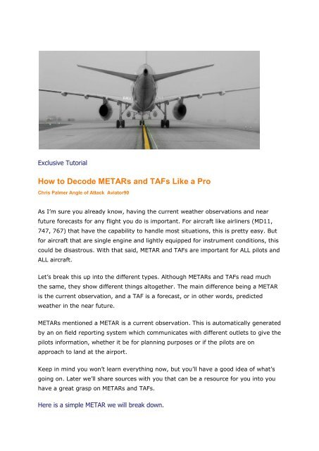
Exclusive Tu<strong>to</strong>rial<br />
<strong>How</strong> <strong>to</strong> <strong>Decode</strong> <strong>METARs</strong> <strong>and</strong> <strong>TAFs</strong> <strong>Like</strong> a <strong>Pro</strong><br />
Chris Palmer Angle of Attack Avia<strong>to</strong>r90<br />
As I’m sure you already know, having the current weather observations <strong>and</strong> near<br />
future forecasts for any flight you do is important. For aircraft like airliners (MD11,<br />
747, 767) that have the capability <strong>to</strong> h<strong>and</strong>le most situations, this is pretty easy. But<br />
for aircraft that are single engine <strong>and</strong> lightly equipped for instrument conditions, this<br />
could be disastrous. With that said, METAR <strong>and</strong> <strong>TAFs</strong> are important for ALL pilots <strong>and</strong><br />
ALL aircraft.<br />
Let’s break this up in<strong>to</strong> the different types. Although <strong>METARs</strong> <strong>and</strong> <strong>TAFs</strong> read much<br />
the same, they show different things al<strong>to</strong>gether. The main difference being a METAR<br />
is the current observation, <strong>and</strong> a TAF is a forecast, or in other words, predicted<br />
weather in the near future.<br />
<strong>METARs</strong> mentioned a METAR is a current observation. This is au<strong>to</strong>matically generated<br />
by an on field reporting system which communicates with different outlets <strong>to</strong> give the<br />
pilots information, whether it be for planning purposes or if the pilots are on<br />
approach <strong>to</strong> l<strong>and</strong> at the airport.<br />
Keep in mind you won’t learn everything now, but you’ll have a good idea of what’s<br />
going on. Later we’ll share sources with you that can be a resource for you in<strong>to</strong> you<br />
have a great grasp on <strong>METARs</strong> <strong>and</strong> <strong>TAFs</strong>.<br />
Here is a simple METAR we will break down.
KSLC 192353Z 30004KT 10SM CLR 29/02 A3000 RMK AO2 SLP110<br />
T02940017 10306 20261 56014<br />
Location <br />
KSLC is simply the airport of the observation, in ICAO (<strong>Pro</strong>nounced I-K-OH in one<br />
word) format.<br />
Date <strong>and</strong> Time<br />
192353Z is broken down in<strong>to</strong> 2 sections. The first 2 numbers are the date of the<br />
month. The next 5 digits are the four digit time <strong>and</strong> Z for Zulu. So, this METAR was<br />
given on the 19th day of the Month at 2353Z.<br />
Wind <br />
30004KT is also broken in<strong>to</strong> two parts. The first three digits are the wind direction,<br />
<strong>and</strong> last two numbers is the windspeed in knots, noted by KT.<br />
Visibility<br />
10SM is the current visibility for the airport. This gets a bit for complicated when we<br />
get in instrument conditions. Generally, 10SM means it is completely clear <strong>and</strong><br />
visible. This may also be noted as P6SM which st<strong>and</strong>s for 6 statute miles <strong>and</strong> plus<br />
(beyond)<br />
Clouds<br />
CLR means the area is clear of clouds. As you can see, CLR is very easily translated<br />
in<strong>to</strong> what it needs <strong>to</strong> be. As a simmer or even a pilot, most abbreviations can be<br />
worked out very easily with just a little thought. With that said, other METAR<br />
abbreviations make no sense. For example, mist in the area is noted in a METAR by<br />
BR. Tell me how that makes sense.<br />
Temperature <strong>and</strong> Dewpoint <br />
29/02 is first temperature in Celsius, followed by the dewpoint. A small Temperature<br />
<strong>and</strong> Dewpoint spread usually means that there will be more clouds in the area <strong>and</strong>/or<br />
less visibility.<br />
Barometric Pressure/Altimeter Setting<br />
A3000 is the altimeter setting <strong>to</strong> be used by the pilot. This is the current pressure for<br />
the airport. In addition, for those areas of the world that use Millibars, this will show<br />
more like Q1011 rather than A3000.<br />
RMK st<strong>and</strong>s for Remarks.
Station Type <br />
AO2 is a particular type of weather reporting station that can ‘discriminate’ if there is<br />
precipitation or not. You won’t always see this in a METAR.<br />
Sea Level Pressure<br />
For those of you in the countries using millibars, SLP110 is the setting you’ll use, as<br />
we discussed before.<br />
Precise Temperature <strong>and</strong> Dewpoint <br />
T02940017 notes our exact temperature <strong>and</strong> dewpoint. In this case, 29.4 <strong>and</strong> 1.7<br />
degrees Celsius, respectively.<br />
The last three sections are either jibberish or very advanced for this particular<br />
METAR. As a pilot you’ll eventually learn what is important for your observation <strong>and</strong><br />
what isn’t. By using the resources we provide at the end of this tu<strong>to</strong>rial, you’ll be<br />
able <strong>to</strong> find answers <strong>to</strong> most of your questions.<br />
Now for a more complex METAR<br />
EIDW 092507Z 24035G55KT 210V270 1700 +SHRA BKN007 OVC015CB<br />
08/07<br />
The first two sections need not be explained again.<br />
Winds <br />
24035G55KT The winds are now much more interesting. The first part remains<br />
unchanged, <strong>and</strong> in this case we are looking at winds from 240 at 35 knots. The<br />
addon means that there are Gusts of 55 knots in the mix, although these are not<br />
sustained winds.<br />
The next chunk, 210V270, is also winds. This means that the winds are variable<br />
between 210 <strong>and</strong> 270 heading. 240, from the first chunk of winds, is the average.<br />
Visibility/RVR<br />
In this case, 1700 is shown for visibility. This is not 1700 statute miles. Rather, it’s<br />
1700 Meters. This means the visibility is quite low.<br />
In this case, you can see it’s around 1 SM visibility. (1700= somewhere just above<br />
1600, which is just under a mile above)
Precipitation<br />
Omitted if not used, but in this case we see +SHRA. This means, SH, showers, RA,<br />
rain, <strong>and</strong> plus, is heavy. So, we are looking at moderate rain showers.<br />
Clouds<br />
BKN007 notes a significant cloud layer. Simply add two 0’s on<strong>to</strong> this <strong>to</strong> get the<br />
altitude of the cloud layer. In this case, we have broken clouds, which can be just<br />
under overcast, at 700 feet.<br />
OVC015CB notes that we have overcast (near complete or complete coverage) at<br />
1500 feet. These clouds are CB, slang as Charlie Bravo, which is Cumulonimbus<br />
clouds. Why is this important <strong>to</strong> know Cumuloform clouds are most commonly<br />
known with thunders<strong>to</strong>rms. No one <strong>and</strong> no aircraft messes with a thunders<strong>to</strong>rm <strong>and</strong><br />
feels good about it!<br />
Temperature/Dewpoint <br />
As mentioned before, a small spread between these two values will generally mean<br />
poor visibility. In this case, it is a perfect example.<br />
This does it for what we will teach you about <strong>METARs</strong>. Here are some great resources<br />
<strong>to</strong> go out <strong>and</strong> study on your own:<br />
Click HERE<br />
<strong>TAFs</strong> <br />
TAF st<strong>and</strong>s for Terminal Aerodrome Forecast. What does Aerodrome mean! In this<br />
case, it doesn’t much matter. What you do need <strong>to</strong> know is that depending on<br />
location, these will be anywhere between 9 <strong>and</strong> 24 hour forecasts.<br />
<strong>TAFs</strong> look much the same as <strong>METARs</strong>, so most of it won’t need <strong>to</strong> be covered. But,<br />
here are a few differences:<br />
KORD 192335Z 2000/2106 14012G18KT 6SM -SHRA SCT015<br />
BKN035 FM200100 17012G20KT P6SM BKN035 BKN060 TEMPO<br />
2003/2004 5SM -TSRA BKN018CB FM200400 20012G20KT P6SM SCT020<br />
SCT050 SCT120<br />
Location<br />
As usual, the ICAO code is given. In this case, KORD.
Time <br />
This report was generated at 192335Z. Translated, it was reported on the 19th day<br />
of the month at 2335Z.<br />
Effective Dates/Times<br />
This TAF is effective 2000/2106. This means 20th day of the month at 0000z (2000)<br />
between (/) 21st day of the month at 0600z (2106)<br />
On the rest of the first line, we get the start of the forecast. In this case, 0000z on<br />
the 20th day of the month.<br />
FM200100 means basically from this time forward ( 20th day of the month, 0100z)<br />
this is what the weather will be (until changed on another line).<br />
TEMPO 2003/2004 is a small slot of time where the forecast (on the remaining part<br />
of the line) will be valid. In this case, on the 20th day at 0300z <strong>to</strong> 20th day 0400z.<br />
The rest of the data shown are things that are common between <strong>METARs</strong> <strong>and</strong> <strong>TAFs</strong>.<br />
Look the data up for questions as you are planning <strong>and</strong> using this data, so you’ll get<br />
use <strong>to</strong> it.<br />
Additional information can be found HERE<br />
That does it for our simple explanation <strong>and</strong> introduction <strong>to</strong> <strong>TAFs</strong> <strong>and</strong> <strong>METARs</strong>!<br />
Throttle On!<br />
Chris Palmer