Rikaline GPS-6010 GPS Receiver - StarGPS
Rikaline GPS-6010 GPS Receiver - StarGPS
Rikaline GPS-6010 GPS Receiver - StarGPS

Create successful ePaper yourself
Turn your PDF publications into a flip-book with our unique Google optimized e-Paper software.
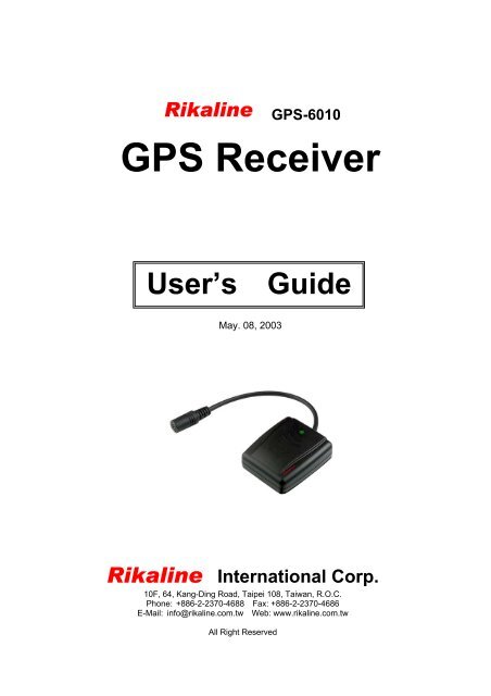
<strong>Rikaline</strong><br />
<strong>GPS</strong> <strong>Receiver</strong><br />
User’s Guide<br />
May. 08, 2003<br />
<strong>Rikaline</strong> International Corp.<br />
10F, 64, Kang-Ding Road, Taipei 108, Taiwan, R.O.C.<br />
Phone: +886-2-2370-4688 Fax: +886-2-2370-4686<br />
E-Mail: info@rikaline.com.tw Web: www.rikaline.com.tw<br />
All Right Reserved<br />
<strong>GPS</strong>-<strong>6010</strong>
<strong>GPS</strong>-<strong>6010</strong> Operating Manual <strong>Rikaline</strong><br />
TABLE OF CONTENTS<br />
0. Quick USe ……….………………………………………………………………………………….. 3<br />
0.1 Check <strong>GPS</strong> Package ..………………………………………………………………….. 3<br />
0.2 Check Connector …..…………………………………………………………………….. 3<br />
0.3 Connect <strong>GPS</strong>-<strong>6010</strong> to your machine ………………………………………………. 3<br />
0.4 Turn on your machine …………………………………………………………………….. 3<br />
1. Introduction ……………………………………………………………………………………….. 4<br />
1.1 Overview …………………………………………………………………………………….. 4<br />
1.2 Features …………………………………………………………………………………….. 4<br />
1.3 Technical Specifications ……………………………………………………………….. 4<br />
2. Operational Characteristics ……………………………………………………………….… 6<br />
2.1 Initialization …………………………………………………………………………………. 6<br />
2.2 Navigation …………………………………………………………………………………. 6<br />
3. Hardware Interface ………………………………………………………………………….…… 7<br />
3.1 Dimension ………………………………………………………………………………….… 7<br />
3.2 Hardware Interface …..……………………………………………………………….…… 7<br />
3.3 Connector ………………………………………………………………………………….… 7<br />
3.4 Accessories …………………………………………………………………………………. 8<br />
4. USB Driver ……………………………………………………………………………………….… 10<br />
4.1 System Requirement ……………………………………………………………………… 10<br />
4.2 Installation ………………….…………………………………………………………….… 10<br />
4.3 Important …………….………………………………………………………………………. 10<br />
5. Waranty …………………………………………………………………………………………….… 10<br />
Appendix A Software Inferface ……………………………………………………………. 11<br />
A.1 NMEA Transmitted Sentences ……………………………………………………..… 11<br />
A.2 RTCM Received Data ………………………………………………………………….. 14<br />
Appendix B Earth Datums and Output Setting ……………………………………… 15<br />
B.1 Earth Datums ………..…………………………………………………………………….. 15<br />
B.2 Setting ……..……………………………………………………………………………….… 15<br />
Appendix C Products Information ……………………………………………………….. 16<br />
C.1 Product Options ……………………………………………………………….………… 16<br />
C.2 Accessories ………………………………………………………………………….……… 16<br />
C.3 Products Combination ………….………………………………………………………. 16<br />
<strong>Rikaline</strong> International Corp. 10F, 64, Kang-Ding Road, Taipei 108, Taiwan<br />
Tel: ++886 2 2370 4688 Fax: ++886 2 2370 4686 E-Mail: info@rikaline.com.tw Web: www.rikaline.com.tw<br />
2
0. Quick Use<br />
<strong>GPS</strong>-<strong>6010</strong> Operating Manual <strong>Rikaline</strong><br />
0.1 Check <strong>GPS</strong> Package<br />
0.1.1 Standard Package<br />
<strong>GPS</strong>-<strong>6010</strong> (<strong>GPS</strong> <strong>Receiver</strong>) + Magnetic pad with mounting screws + CD + Warranty Card + quick<br />
installation reference.<br />
0.1.2 Optional Package<br />
The shop may bundle different accessories for you as follows:<br />
1. PC Cable<br />
2. PDA Cable<br />
3. PDA Holder<br />
4. Software (Navigation Software + Digital Map)<br />
5. Others<br />
0.2 Check connector<br />
1. A-6011 RS-232 Serial Port Connector<br />
2. A-6013 USB Connector, Please install USB driver first.<br />
3. When you connect your PDA to <strong>GPS</strong>-<strong>6010</strong>, you need an optional cable. Check the e mark (FCC) for<br />
safety and ensure the cigarette adapter with correct model number to avoid damaging your PDA.<br />
4. Various cables are ready for optional devices.<br />
0.3 Connect <strong>GPS</strong>-<strong>6010</strong> to your machine.<br />
0.4 Turn on your machine.<br />
0.5 Your <strong>GPS</strong>-<strong>6010</strong> starts to provide you full <strong>GPS</strong> function.<br />
<strong>Rikaline</strong> International Corp. 10F, 64, Kang-Ding Road, Taipei 108, Taiwan<br />
Tel: ++886 2 2370 4688 Fax: ++886 2 2370 4686 E-Mail: info@rikaline.com.tw Web: www.rikaline.com.tw<br />
3
1. Introduction<br />
1.1 Overview<br />
<strong>GPS</strong>-<strong>6010</strong> Operating Manual <strong>Rikaline</strong><br />
The <strong>Rikaline</strong> <strong>GPS</strong>-<strong>6010</strong> Smart Antenna is a total solution <strong>GPS</strong> receiver, designed based on SiRF Star II<br />
Architecture. This positioning application meets strict needs such as car navigation, mapping, surveying,<br />
security, agriculture and so on. Only clear view of sky and certain power supply are necessary to the unit. It<br />
communicates with other electronic utilities via compatible dual-channel through RS-232 or TTL and saves<br />
critical satellite data by built–in backup memory. With low power consumption, the <strong>GPS</strong>-<strong>6010</strong> tracks up to 12<br />
satellites at a time, re-acquires satellite signals in 100 ms and updates position data every second.<br />
Trickle-Power allows the unit operates a fraction of the time and Push-to-Fix permits user to have a quick<br />
position fix even though the receiver usually stays off.<br />
1.2 Features<br />
The <strong>GPS</strong>-<strong>6010</strong> provides a host of features that make it easy for integration and use.<br />
1. SiRF Star II chipset with embedded ARM7TDMI CPU available for customized applications in firmware.<br />
2. High performance receiver tracks up to 12 satellites while providing first fast fix and low power<br />
consumption.<br />
3. Differential capability utilizes real-time RTCM corrections producing 1-5 meter position accuracy.<br />
4. Compact design ideal for applications with minimal space.<br />
5. A rechargeable battery sustains internal clock and memory. The battery is recharged during normal<br />
operation.<br />
6. User initialization is not required.<br />
7. Dual communication channels and user selectable baud rates allow maximum interface capability and<br />
flexibility.<br />
8. Optional communication levels, RS-232 and TTL meet ordinary application and new fashions of connecting<br />
PDA with TTL or RS-232 output.<br />
9. FLASH based program memory: New software revisions upgradeable through serial interface.<br />
10. LED display status: The LED provides users visible positioning status. LED “ON” when power connected<br />
and “BLINKING” when <strong>GPS</strong>-<strong>6010</strong> position identified. No more extra device needed.<br />
11. Built-in WAAS demodulator.<br />
12. Water proof (1 meter) design for all weather.<br />
1.3 Technology specifications<br />
1.3.1 Physical Dimension<br />
Single construction integrated antenna/receiver.<br />
Size: 59.0(W) x 51.0 (47.3)(D) x 20.6(H) (mm)<br />
2.32"(W) x 2.00"(1.86)(D) x 0.81"(H).<br />
1.3.2 Environmental Characteristics<br />
1) Operating temperature: -40 o C to +85 o C(internal temperature).<br />
2) Storage temperature: -55 o C to +100 o C.<br />
1.3.3 Electrical Characteristics<br />
1) Input voltage: +4.75 ~ 5.5 VDC without accessories.<br />
+6 ~ 30VDC with accessory A-6014.<br />
2) Backup power: 3V Rechargeable Lithium cell battery, up to 767 hours (31.9 days) discharge.<br />
1.3.4 Performance<br />
1) Tracks up to 12 satellites.<br />
2) Update rate: 1 second.<br />
3) Acquisition time<br />
Reacquisition 0.1 sec., averaged<br />
<strong>Rikaline</strong> International Corp. 10F, 64, Kang-Ding Road, Taipei 108, Taiwan<br />
Tel: ++886 2 2370 4688 Fax: ++886 2 2370 4686 E-Mail: info@rikaline.com.tw Web: www.rikaline.com.tw<br />
4
Hot start 8 sec., averaged<br />
Warm start 38 sec., averaged<br />
Cold start 45 sec., averaged<br />
4) Position accuracy:<br />
A) Non D<strong>GPS</strong> (Differential <strong>GPS</strong>)<br />
Position 5-25 meter CEP with SA off<br />
Velocity 0.1 meters/second, with SA off<br />
Time 1 microsecond synchronized <strong>GPS</strong> time<br />
B) D<strong>GPS</strong> (Differential <strong>GPS</strong>)<br />
Position 1 to 5 meter, typical<br />
Velocity 0.05 meters/second, typical<br />
5) Dynamic Conditions:<br />
Altitude 18,000 meters (60,000 feet) max<br />
Velocity 515 meters / second (1000 knots) max<br />
Acceleration 4 G, max<br />
Jerk 20 meters/second, max<br />
<strong>GPS</strong>-<strong>6010</strong> Operating Manual <strong>Rikaline</strong><br />
1.3.5 Interfaces<br />
1) Dual channel RS-232 or TTL compatible level, with user selectable baud rate (4800-Default, 9600, 19200,<br />
38400).<br />
2) NMEA 0183 Version 2.2 ASCII output (GPGGA, GPGLL, GPGSA, GPGSV, GPRMC, GPVTG).<br />
3) Real-time Differential Correction input (RTCM SC-104 message types 1, 5 and 9).<br />
4) SiRF protocol.<br />
<strong>Rikaline</strong> International Corp. 10F, 64, Kang-Ding Road, Taipei 108, Taiwan<br />
Tel: ++886 2 2370 4688 Fax: ++886 2 2370 4686 E-Mail: info@rikaline.com.tw Web: www.rikaline.com.tw<br />
5
2. Operational characteristics<br />
<strong>GPS</strong>-<strong>6010</strong> Operating Manual <strong>Rikaline</strong><br />
2.1 Initialization<br />
As soon as the initial self-test is complete, the <strong>GPS</strong>-<strong>6010</strong> begins the process of satellite acquisition and<br />
tracking automatically. Under normal circumstances, it takes approximately 45 seconds to achieve a position fix,<br />
38 seconds if ephemeris data is known. After a position fix has been calculated, information about valid position,<br />
velocity and time is transmitted over the output channel.<br />
The <strong>GPS</strong>-<strong>6010</strong> utilizes initial data, such as last stored position, date, time and satellite orbital data, to<br />
achieve maximum acquisition performance. If significant inaccuracy exists in the initial data, or the orbital data<br />
is obsolete, it may take more time to achieve a navigation solution. The <strong>GPS</strong>-<strong>6010</strong> Auto-locate feature is<br />
capable of automatically determining a navigation solution without intervention from the host system. However,<br />
acquisition performance can be improved when the host system initializes the <strong>GPS</strong>-<strong>6010</strong> in the following<br />
situation:<br />
1) Moving further than 1,500 kilometers.<br />
2) Failure of data storage due to the inactive internal memory battery.<br />
2.2 Navigation<br />
After the acquisition process is complete, the <strong>GPS</strong>-<strong>6010</strong> sends valid navigation information over output<br />
channels. These data include:<br />
1) Latitude/longitude/altitude<br />
2) Velocity<br />
3) Date/time<br />
4) Error estimates<br />
5) Satellite and receiver status<br />
The <strong>GPS</strong>-<strong>6010</strong> sets the default of auto-searching for real-time differential corrections in RTCM SC-104<br />
standard format, with the message types 1, 5, or 9. It accomplishes the satellite data to generate a differential<br />
(D<strong>GPS</strong>) solution. The host system, at its option, may also command the <strong>GPS</strong>-<strong>6010</strong> to output a position<br />
whenever a differential solution is available.<br />
<strong>Rikaline</strong> International Corp. 10F, 64, Kang-Ding Road, Taipei 108, Taiwan<br />
Tel: ++886 2 2370 4688 Fax: ++886 2 2370 4686 E-Mail: info@rikaline.com.tw Web: www.rikaline.com.tw<br />
6
3. Hardware interface<br />
3.1 Dimension<br />
Size: 59.0(W) x 51.0 (47.3)(D) x 20.6(H) (mm)<br />
2.32"(W) x 2.00"(1.86)(D) x 0.81"(H).<br />
<strong>GPS</strong>-<strong>6010</strong> Operating Manual <strong>Rikaline</strong><br />
3.2 Hardware Interface<br />
The <strong>GPS</strong>-<strong>6010</strong> includes an antenna in a unique style waterproof gadget. Simply connect PS-2 female<br />
connector to one of the optional accessories and link to either your notebook PC, PDA or other devices. The<br />
one-piece cigarette adapter allows you to connect <strong>GPS</strong>-<strong>6010</strong> to your PDAs. Optional color, input voltage and<br />
output connector are listed and described below:<br />
A-6017<br />
3.3 Connector<br />
Standard cable: 2 meters with female PS-2 connector.<br />
The <strong>GPS</strong>-<strong>6010</strong> is also equipped with optional customized connectors.<br />
3.3.1 Function definition of standard PS-2 composite connector<br />
Pin Signal<br />
1 Tx (RS-232)<br />
2 +5VDC<br />
3 Tx (TTL)<br />
4 Ground<br />
5 Rx (TTL)<br />
6 Rx (RS-232)<br />
<strong>Rikaline</strong> International Corp. 10F, 64, Kang-Ding Road, Taipei 108, Taiwan<br />
Tel: ++886 2 2370 4688 Fax: ++886 2 2370 4686 E-Mail: info@rikaline.com.tw Web: www.rikaline.com.tw<br />
7
3.4 Accessories<br />
3.4.1 A-6011 Mini Din Female and PS-2 male connector:<br />
Cable Length: To <strong>GPS</strong>-<strong>6010</strong>: 1 meter<br />
RS-232 to PS-2: 45 cm<br />
3.4.1.1 Mini Din Female connector function definition:<br />
3.4.1.2 PS2 composite connector function definition (to PC):<br />
<strong>GPS</strong>-<strong>6010</strong> Operating Manual <strong>Rikaline</strong><br />
Pin Signal Name<br />
1 N.C<br />
2 Tx<br />
3 Rx<br />
4 N.C<br />
5 Ground<br />
6 N.C<br />
7 N.C<br />
8 N.C<br />
9 D<strong>GPS</strong> in<br />
N.C = No connection<br />
<strong>Rikaline</strong> International Corp. 10F, 64, Kang-Ding Road, Taipei 108, Taiwan<br />
Tel: ++886 2 2370 4688 Fax: ++886 2 2370 4686 E-Mail: info@rikaline.com.tw Web: www.rikaline.com.tw<br />
Pin Signal Name<br />
1 +5V<br />
2 N.C<br />
3 N.C<br />
4 Ground<br />
5 N.C<br />
6 N.C<br />
N.C = No connection<br />
Remarks: A-6011-S is for COM+PS-2 converting to PS-2 female. If you have an old <strong>GPS</strong> receiver with<br />
standard COM + PS-2 male connector, you may choose an A-6011-S. Then you can use your old<br />
<strong>GPS</strong> receiver with PDA or USB version PC. Casio PDAs is excluded.<br />
3.4.2 A-6013 USB connector<br />
The function definition of the A Type USB connector is as follows:<br />
Pin Signal Name<br />
1 +5V<br />
2 D +<br />
3 D -<br />
4 Ground<br />
Remarks: A-6013-C is for COM+PS-2 converting to USB<br />
If you have an old <strong>GPS</strong> receiver with standard COM + PS-2 male connector, you may choose an<br />
A-6013-C. Then you can use your old <strong>GPS</strong> receiver with USB version PC.<br />
8
3.4.3 A-6014 High power connector<br />
<strong>GPS</strong>-<strong>6010</strong> Operating Manual <strong>Rikaline</strong><br />
3.4.4 A-6015 Magnetic Pad (and Mounting Bracket)<br />
The <strong>GPS</strong>-<strong>6010</strong> is also equipped with a standard magnetic pad (Mounting Bracket), A-6015 for putting on<br />
top of the car, a plan surface or mounting on a base.<br />
Used as a Mounting Bracket<br />
Fasten 3 screws (Enclosed) through the magnet pad as a fixed holder.<br />
3.4.5 A-6016 Optional Cigarette Adapter<br />
The optional cigarette adapter with 2-meter core cable is for using in a car or boat. It must be used<br />
together with an A-6011 or an old standard COM + PS-2 <strong>GPS</strong> receiver.<br />
Input voltage: DC12V - 26V<br />
Top View<br />
Push <strong>GPS</strong>-<strong>6010</strong><br />
on Magnet pad<br />
Front View<br />
3.4.6 A-6017 Cigarette adapter and PDA connector:<br />
Color Signal<br />
Black Ground<br />
Red +6~30 VDC<br />
Green Tx<br />
White Rx<br />
Orange D<strong>GPS</strong> IN<br />
Part No. Application Part No. Application<br />
A-6017-A ASUA A-6017-N NEC<br />
A-6017-AR ACER S series A-6017-P Palm<br />
A-6017-B BESTA I-WINNA A-6017-Q I-Paq<br />
A-6017-C Casio A-6017-S Sony Series<br />
A-6017-D Dell Axim A-6017-SM Siemens SX-45<br />
A-6017-H HP Jornada A-6017-T Toshiba Series<br />
A-6017-L Siemens LOOX A-6017-X O2-XDA / T-Mobile - MDA<br />
A-6017-M Mitac Mio<br />
<strong>Rikaline</strong> International Corp. 10F, 64, Kang-Ding Road, Taipei 108, Taiwan<br />
Tel: ++886 2 2370 4688 Fax: ++886 2 2370 4686 E-Mail: info@rikaline.com.tw Web: www.rikaline.com.tw<br />
9
4. USB Driver<br />
4.1 System Requirements<br />
<strong>GPS</strong>-<strong>6010</strong> Operating Manual <strong>Rikaline</strong><br />
IBM, Pentium or above and other compatible PC; 16 MB and above memory; Windows 98/Me/2000; VGA<br />
Graphic Adapter.<br />
4.2 Installation<br />
1. Copy entire folder from CD to hard disk.<br />
2. Connect <strong>GPS</strong>-<strong>6010</strong> USB connector to computer. While the computer automatically starts the installation<br />
program, please direct the driver to the folder.<br />
3. After the installation is complete, go to and select to verify if a<br />
virtual COM port was created.<br />
4.3 Important<br />
Verify the COM port # to start using your own navigating software.<br />
1. Click menu, select , then enter .<br />
2. After entering , select .<br />
3. Select .<br />
4. Find the and check the Virtual COM Port, which was created by the USB driver. Please<br />
note that the Virtual COM Port number might be different from every computer. Before using navigating<br />
software, please confirm the COM Port numbers created by your computer and provided by your navigation<br />
software. They must be the same Com Port numbers. Otherwise, the navigating software won’t receive the<br />
satellite signal for the un-match COM Port setting.<br />
5. Warranty<br />
The <strong>GPS</strong>-<strong>6010</strong> is warranted to be free from defects in material and functions for one year from the date of<br />
purchase. Any failure of this product within this period under normal conditions will be replaced at no charge to<br />
the customers.<br />
<strong>Rikaline</strong> International Corp. 10F, 64, Kang-Ding Road, Taipei 108, Taiwan<br />
Tel: ++886 2 2370 4688 Fax: ++886 2 2370 4686 E-Mail: info@rikaline.com.tw Web: www.rikaline.com.tw<br />
10
Appendix A Software Interface<br />
<strong>GPS</strong>-<strong>6010</strong> Operating Manual <strong>Rikaline</strong><br />
The <strong>GPS</strong>-<strong>6010</strong> interface protocol is based on the National Marine Electronics Association's NMEA 0183<br />
ASC Ⅱ interface specification, which is defined in NMEA 0183, Version 2.2 and the Radio Technical<br />
Commission for Maritime Services (RTCM Recommended Standards For Differential Navstar <strong>GPS</strong> Service,<br />
Version 2.1, RTCM Special Committee No.104).<br />
A.1 NMEA Transmitted Messages<br />
The <strong>GPS</strong>-<strong>6010</strong> supported by SiRF Technology Inc. also outputs data in NMEA-0183 format as defined by<br />
the National Marine Electronics Association (NMEA), Standard.<br />
The default communication parameters for NMEA output are 4800 baud, 8 data bits, stop bit, and no parity.<br />
Table A-1 NMEA-0183 Output Messages<br />
NMEA Sentence Description<br />
GPGGA Global positioning system fixed data<br />
GPGLL Geographic position latitude \ longitude<br />
GPGSA GNSS DOP and active satellites<br />
GPGSV GNSS satellites in view.<br />
GPRMC Recommended minimum specific GNSS data<br />
GPVTG Coruse over ground and ground speed<br />
A.1.1 Global Positioning System Fix Data (GGA)<br />
Table A-2 contains the values for the following example:<br />
$GPGGA,161229.487,3723.2475,N,12158.3416,W,1,07,1.0,9.0,M, , , ,0000*18<br />
Table A-2 GGA Data Format<br />
Name Example Units Description<br />
Message ID $GPGGA GGA protocol header<br />
UTC Time 161229.487 Hhmmss.sss<br />
Latitude 3723.2475 ddmm.mmmm<br />
N/S Indicator N N=north or S=south<br />
Longitude 12158.3416 dddmm.mmmm<br />
E/W Indicator W E=east or W=west<br />
Position Fix Indicator 1 See Table 5-3<br />
Satellites Used 07 Range 0 to 12<br />
HDOP 1.0 Horizontal Dilution of Precision<br />
MSL Altitude 9.0 Meters<br />
Units M Meters<br />
Geoid Separation Meters<br />
Units M Meters<br />
Age of Diff. Corr. second Null fields when D<strong>GPS</strong> is not used<br />
Diff. Ref. Station ID 0000<br />
Checksum *18<br />
End of message termination<br />
Table A-3 Position Fix Indicator<br />
Value Description<br />
0 0 Fix not available or invalid<br />
1 <strong>GPS</strong> SPS Mode, fix valid<br />
2 Differential <strong>GPS</strong>, SPS Mode, fix valid<br />
3 <strong>GPS</strong> PPS Mode, fix valid<br />
<strong>Rikaline</strong> International Corp. 10F, 64, Kang-Ding Road, Taipei 108, Taiwan<br />
Tel: ++886 2 2370 4688 Fax: ++886 2 2370 4686 E-Mail: info@rikaline.com.tw Web: www.rikaline.com.tw<br />
11
A.1.2 Geographic Position with Latitude/Longitude (GLL)<br />
Table A-4 contains the values for the following example:<br />
$GPGLL,3723.2475,N,12158.3416,W,161229.487,A*2C<br />
<strong>GPS</strong>-<strong>6010</strong> Operating Manual <strong>Rikaline</strong><br />
Table A-4 GLL Data Format<br />
Name Example Units Description<br />
Message ID $GPGLL GLL protocol header<br />
Latitude 3723.2475 ddmm.mmmm<br />
N/S Indicator N N=north or S=south<br />
Longitude 12158.3416 dddmm.mmmm<br />
E/W Indicator W E=east or W=west<br />
UTC Position 161229.487 hhmmss.sss<br />
Status A A=data valid or V=data not valid<br />
Checksum *2C<br />
End of message termination<br />
A.1.3 GNSS DOP and Active Satellites (GSA)<br />
Table A-5 contains the values for the following example:<br />
$GPGSA,A,3,07,02,26,27,09,04,15, , , , , ,1.8,1.0,1.5*33<br />
Table A-5 GSA Data Format<br />
Name Example Units Description<br />
Message ID $GPGSA GSA protocol header<br />
Mode 1 A See Table 5-6<br />
Mode 2 3 See Table 5-7<br />
Satellite Used (1) 07 Sv on Channel 1<br />
Satellite Used (1) 02 Sv on Channel 2<br />
…… ….<br />
Satellite Used Sv on Channel 12<br />
PDOP 1.8 Position Dilution of Precision<br />
HDOP 1.0 Horizontal Dilution of Precision<br />
VDOP 1.5 Vertical Dilution of Precision<br />
Checksum *33<br />
End of message termination<br />
(1) Satellite used in solution.<br />
Table A-6 Mode 1<br />
Value Description<br />
M Manual—forced to operate in 2D or 3D mode<br />
A 2D Automatic—allowed to automatically switch 2D/3D<br />
Table A-7 Mode 2<br />
Value Description<br />
1 Fix Not Available<br />
2 2D<br />
3 3D<br />
A.1.4 GNSS Satellites in View (GSV)<br />
Table A-8 contains the values for the following example:<br />
$GPGSV,2,1,07,07,79,048,42,02,51,062,43,26,36,256,42,27,27,138,42*71<br />
$GPGSV,2,2,07,09,23,313,42,04,19,159,41,15,12,041,42*41<br />
<strong>Rikaline</strong> International Corp. 10F, 64, Kang-Ding Road, Taipei 108, Taiwan<br />
Tel: ++886 2 2370 4688 Fax: ++886 2 2370 4686 E-Mail: info@rikaline.com.tw Web: www.rikaline.com.tw<br />
12
<strong>GPS</strong>-<strong>6010</strong> Operating Manual <strong>Rikaline</strong><br />
Table A-8 GSV Data Format<br />
Name Example Units Description<br />
Message ID $GPGSV GSV protocol header<br />
Number of Messages 2 Range 1 to 3<br />
Message Number 1 Range 1 to 3<br />
Satellites in View 07 Range 1 to 12<br />
Satellite ID 07 Channel 1 (Range 1 to 32)<br />
Elevation 79 degrees Channel 1 (Maximum 90)<br />
Azimuth 048 degrees Channel 1 (True, Range 0 to 359)<br />
SNR (C/No) 42 dBHz Range 0 to 99, null when not tracking<br />
.... ....<br />
Satellite ID 27 Channel 4 (Range 1 to 32)<br />
Elevation 27 degrees Channel 4 (Maximum 90)<br />
Azimuth 138 degrees Channel 4 (True, Range 0 to 359)<br />
SNR (C/No) 42 dBHz Range 0 to 99, null when not tracking<br />
Checksum *71<br />
End of message termination<br />
NOTE: Items ,, and repeat for each satellite in view to a maximum of four (4) satellites per<br />
sentence. Additional satellites in view information must be sent in subsequent sentences. These fields will be<br />
null if unused.<br />
A.1.5 Recommended Minimum Specific GNSS Data (RMC)<br />
Table A-9 contains the values for the following example:<br />
$GPRMC,161229.487,A,3723.2475,N,12158.3416,W,0.13,309.62,120598, ,*10<br />
Table A-9 RMC Data Format<br />
Name Example Units Description<br />
Message ID $GPRMC RMC protocol header<br />
UTC Time 161229.487 hhmmss.sss<br />
Status A A=data valid or V=data not valid<br />
Latitude 3723.2475 ddmm.mmmm<br />
N/S Indicator N N=north or S=south<br />
Longitude 12158.3416 dddmm.mmmm<br />
E/W Indicator W E=east or W=west<br />
Speed Over Ground 0.13 Knots<br />
Course Over Ground 309.62 Degrees True<br />
Date 120598 ddmmyy<br />
Magnetic Variation (1) Degrees E=east or W=west<br />
Checksum *10<br />
End of message termination<br />
(1) SiRF Technology Inc. does not support magnetic declination. All “course over ground” data are<br />
geodetic WGS84 directions.<br />
A.1.6 Course Over Ground and Ground Speed<br />
Table A-10 contains the values for the following example:<br />
$GPVTG,309.62,T, ,M,0.13,N,0.2,K*6E<br />
Table A-10 VTG Data Format<br />
Name Example Units Description<br />
Message ID $GPVTG VTG protocol header<br />
Course 309.62 Degrees Measured heading<br />
Reference T True<br />
Course Degrees Measured heading<br />
<strong>Rikaline</strong> International Corp. 10F, 64, Kang-Ding Road, Taipei 108, Taiwan<br />
Tel: ++886 2 2370 4688 Fax: ++886 2 2370 4686 E-Mail: info@rikaline.com.tw Web: www.rikaline.com.tw<br />
13
<strong>GPS</strong>-<strong>6010</strong> Operating Manual <strong>Rikaline</strong><br />
Reference M Magnetic (1)<br />
Speed 0.13 Knots Measured horizontal speed<br />
Units N Knots<br />
Speed 0.2 Km/hr Measured horizontal speed<br />
Units K Kilometers per hour<br />
Checksum *6E<br />
End of message termination<br />
(1) SiRF Technology Inc. does not support magnetic declination. All “course over ground” data are<br />
geodetic WGS84 directions.<br />
A.2 RTCM Received Data<br />
The default communication parameters for D<strong>GPS</strong> Input are 9600 baud, 8 data bits, stop bit, and no parity.<br />
Position accuracy of less than 5 meters can be achieved with the <strong>GPS</strong>-<strong>6010</strong> by using Differential <strong>GPS</strong> (D<strong>GPS</strong>)<br />
real-time pseudo-range correction data in RTCM SC-104 format, with message types 1, 5, or 9. As using<br />
D<strong>GPS</strong> receiver with different communication parameters, <strong>GPS</strong>-<strong>6010</strong> may decode the data correctly to generate<br />
accurate messages and save them in battery-back SRAM for later computing.<br />
<strong>Rikaline</strong> International Corp. 10F, 64, Kang-Ding Road, Taipei 108, Taiwan<br />
Tel: ++886 2 2370 4688 Fax: ++886 2 2370 4686 E-Mail: info@rikaline.com.tw Web: www.rikaline.com.tw<br />
14
<strong>GPS</strong>-<strong>6010</strong> Operating Manual <strong>Rikaline</strong><br />
Appendix B Earth Datums & Output Setting<br />
B.1 Earth Datums<br />
The <strong>GPS</strong>-<strong>6010</strong> is built in earth datum with WGS84.<br />
B.2 Setting<br />
B.2.1 Manufacturing Default<br />
Datum: WGS84.<br />
Baud Rate: 4800.<br />
Output: GGA, GSA, GSV, RMC.<br />
B.2.2 Baud Rate and Output Sentences Setting<br />
B.2.2.1 By SiRFdemo Program<br />
1// Connect your <strong>GPS</strong>-<strong>6010</strong> to PC (either COM or USB)<br />
2// Execute SiRFdemo.exe (Program is in the CD)<br />
3// When “Data Source Setup” shows, select the port (COM 1, 2 or 3….) you used, click “OK”.<br />
4// Click “Action”, select “Open Data Source”, Then you will see lots of sentences shows. All the sentences<br />
start with $GPxxxx. This is NMEA protocol. If you do not see these sentences, please click “View”,<br />
“Select Message”, then click “Development”. The message will appear. If it still shows nothing, then<br />
continue below steps.<br />
5// There is a screen “Selection of Target <strong>Receiver</strong> Software” might appear, please select “SiRFstar II”.<br />
6// Click “Action”, Select “Switch to SiRF Protocol”. Then you will see SiRF binary and the sentences start<br />
with #Time, shows every 4 lines and you can not see the sentences start with $GP. These sentences<br />
are for setting or viewing the <strong>GPS</strong> receiver’s performance. If your software is using standard NMEA<br />
protocol, please do the following:<br />
7// Click “Action”, Select “Switch to NMEA Protocol”. You will see GGA, GSV, GSA and RMC in black and<br />
the Baud Rate is 4800. These are the default we put inside the receiver. Please click “OK”. Then you<br />
can use it as a standard <strong>GPS</strong> receiver. If your software uses different sentence, please choose the<br />
sentences you need.<br />
After above actions, the new setting will be kept in SRAM. If no power supplied to <strong>GPS</strong>-<strong>6010</strong> for more than<br />
than 30 days, user must re-set again when power on.<br />
B.2.2.2 By other SiRF based demo program<br />
There are a few companies or private website providing some very good demo software.<br />
<strong>Rikaline</strong> International Corp. 10F, 64, Kang-Ding Road, Taipei 108, Taiwan<br />
Tel: ++886 2 2370 4688 Fax: ++886 2 2370 4686 E-Mail: info@rikaline.com.tw Web: www.rikaline.com.tw<br />
15
Appendix C Ordering Information<br />
C.1 Product Options<br />
C.1.1 OutPut Level (or Data)<br />
<strong>GPS</strong>-<strong>6010</strong> Operating Manual <strong>Rikaline</strong><br />
<strong>GPS</strong>-<strong>6010</strong>: RS-232 & TTL (Standard) With 2-meter Cable and PS-2 Female Connector.<br />
C.1.2 Color Option<br />
BK Black (Standard)<br />
Other Color: by demand<br />
C.2 Accessories<br />
C.2.1 Cables<br />
A-6011 Com Port connector (For use with standard RS-232 port)<br />
A-6011-S Standard COM+PS-2 converting to PS-2 connector (Enable standard old <strong>GPS</strong> receiver to use<br />
with PDA or PC)<br />
A-6013 USB connector (Use with standard <strong>GPS</strong>-<strong>6010</strong>)<br />
A-6013-C RS-232 <strong>GPS</strong> convert to USB <strong>GPS</strong> (Enable standard old RS-232 <strong>GPS</strong> receiver to be uses as<br />
USB <strong>GPS</strong>)<br />
A-6014 High power adapter, 6-30VDC<br />
A-6015 Magnetic pad (for <strong>GPS</strong>-<strong>6010</strong> only)<br />
A-6016 Cigarette adapter, must be used with A-6011 or standard COM + PS-2 <strong>GPS</strong>.<br />
A-6017 PDA connector with Cigarette Adapter<br />
1 A-6017-A ASUS A-600<br />
2 A-6017-AR ACER S series<br />
3 A-6017-B BESTA I-WINNA<br />
4 A-6017-C Casio E-115<br />
5 A-6017-C1 Casio E-125<br />
6 A-6017-C2 Casio E-200<br />
7 A-6017-D Dell Axim X-5<br />
8 A-6017-H HP Jornada 52xx / 54xx / 56xx<br />
9 A-6017-HS HandSpring Treo<br />
10 A-6017-HS1 HandSpring Visor\Prism<br />
11 A-6017-HS2 HandSpring Edge<br />
12 A-6017-L Siemens LOOX<br />
13 A-6017-M Mitac Mio 528 / 338 / Yakumo Alpha+Delta<br />
14 A-6017-N NEC 300E<br />
15 A-6017-P Palm Vx<br />
16 A-6017-P1 Palm / IBM WorkPad 500/505/Tungsten<br />
17 A-6017-Q I-Paq 36xx / 37xx<br />
18 A-6017-Q1 I-Paq 38xx / 39xx / 54xx<br />
19 A-6017-S Sony N-7xx / S-xx<br />
20 A-6017-S1 Sony T-6xx / NR-xx / SL-xx / SJ-xx<br />
21 A-6017-SM Siemens SX-45<br />
22 A-6017-T1 Toshiba E-570<br />
23 A-6017-T2 Toshiba E-330/740<br />
24 A-6017-X O 2 – XDA / T-Mobiles – MDA<br />
Remarks: All Cigarette Adapters with 2A and e mark no. 021433<br />
<strong>Rikaline</strong> International Corp. 10F, 64, Kang-Ding Road, Taipei 108, Taiwan<br />
Tel: ++886 2 2370 4688 Fax: ++886 2 2370 4686 E-Mail: info@rikaline.com.tw Web: www.rikaline.com.tw<br />
16
C.2.2 PDA Holders<br />
<strong>GPS</strong>-<strong>6010</strong> Operating Manual <strong>Rikaline</strong><br />
1 A-2001 PDA Holder, Suction Cup, 150mm, Short Arm<br />
2 A-2001-L PDA Holder, Suction Cup, 150-320mm Adjustable<br />
3 A-2002 PDA Holder, Suction Cup, 150mm, Short Arm, Magnetic Pad<br />
4 A-2002-L PDA Holder, Suction Cup, 320mm, Long Arm, Magnetic Pad<br />
5 A-2005 PDA Holder, Suction Cup, 150mm, Short Arm, 4-Claw<br />
6 A-2005-L PDA Holder, Suction Cup, 320mm Long Arm, 4-Claw<br />
7 A-2006 PDA Holder, Suction Cup, 150mm Short Arm, 3-Claw<br />
8 A-2006-L PDA Holder, Suction Cup, 150mm Long Arm, 3-Claw<br />
C.3 Products Combination<br />
C.3.1 Standard package<br />
<strong>GPS</strong>-<strong>6010</strong> (<strong>GPS</strong> <strong>Receiver</strong>) + Magnetic pad with mounting screws + Documents CD + Warranty Card +<br />
quick installation reference.<br />
C.3.2 Other Combination for <strong>GPS</strong> Application<br />
C.3.2.1 Navigation<br />
<strong>GPS</strong>-<strong>6010</strong> + A-6011 Notebook Navigation (COM version)<br />
<strong>GPS</strong>-<strong>6010</strong> + A-6013 Notebook Navigation (USB version)<br />
<strong>GPS</strong>-<strong>6010</strong> + A-6017 PDA Navigation<br />
C.3.2.2 Other Popular <strong>GPS</strong> Application<br />
<strong>GPS</strong>-<strong>6010</strong> + <strong>GPS</strong> system for Tracking, Security, Fleet Management…….<br />
<strong>Rikaline</strong> International Corp. 10F, 64, Kang-Ding Road, Taipei 108, Taiwan<br />
Tel: ++886 2 2370 4688 Fax: ++886 2 2370 4686 E-Mail: info@rikaline.com.tw Web: www.rikaline.com.tw<br />
17