Fire and Wildlife in the Mallee - Eyre Peninsula Natural Resources ...
Fire and Wildlife in the Mallee - Eyre Peninsula Natural Resources ...
Fire and Wildlife in the Mallee - Eyre Peninsula Natural Resources ...
- No tags were found...

You also want an ePaper? Increase the reach of your titles
YUMPU automatically turns print PDFs into web optimized ePapers that Google loves.
Study<strong>in</strong>g <strong>the</strong> effects of fire<br />
Scientists from La Trobe <strong>and</strong> Deak<strong>in</strong> Universities, as part of <strong>the</strong> <strong>Mallee</strong> <strong>Fire</strong> <strong>and</strong> Biodiversity Project,<br />
recently <strong>in</strong>vestigated <strong>the</strong> effects of fire on plants <strong>and</strong> animals – birds, mammals, reptiles <strong>and</strong><br />
<strong>in</strong>vertebrates (termites, scorpions, centipedes, psyllids) – <strong>in</strong> <strong>the</strong> Murray <strong>Mallee</strong> region of sou<strong>the</strong>astern<br />
Australia. We carefully selected 28 ‘l<strong>and</strong>scapes’, each 4 km <strong>in</strong> diameter (12.5 km 2 ), which<br />
varied <strong>in</strong> <strong>the</strong>ir composition of post-fire age-classes.<br />
Plants, animals <strong>and</strong> habitat features were surveyed at multiple sites <strong>in</strong> each l<strong>and</strong>scape, selected to<br />
sample different fire age-classes, as well as variation <strong>in</strong> vegetation types <strong>and</strong> topography (dunes,<br />
swales). The study addressed two ma<strong>in</strong> questions:<br />
1. How does <strong>the</strong> flora <strong>and</strong> fauna change <strong>in</strong> relation to time s<strong>in</strong>ce fire<br />
2. What are <strong>the</strong> properties of fire mosaics that are more (or less) suitable for conservation<br />
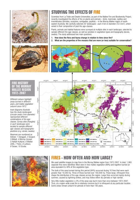
<strong>Fire</strong> history<br />
of <strong>the</strong> Murray<br />
<strong>Mallee</strong> region<br />
1972-2007<br />
Different colours highlight<br />
areas burned <strong>in</strong> different<br />
years, <strong>and</strong> mallee vegetation<br />
unburnt s<strong>in</strong>ce 1972.<br />
Inset diagrams illustrate<br />
how <strong>the</strong> study l<strong>and</strong>scapes<br />
(circular areas 4 km diameter)<br />
represented different<br />
comb<strong>in</strong>ations of fire ageclasses.<br />
Survey sites (triangles)<br />
<strong>in</strong> each l<strong>and</strong>scape were<br />
located to sample different<br />
age-classes <strong>and</strong> topographic<br />
positions (e.g. dunes, swales).<br />
Reserves are numbered as<br />
follows: 1 Danggali, 2 Gluepot,<br />
3 Billiatt, 4 Murray-Sunset,<br />
5 Hattah-Kulkyne, 6 <strong>Mallee</strong><br />
Cliffs, 7 Petro, 8 Le<strong>the</strong>ro,<br />
9 Tarawi, 10 Scotia.<br />
<strong>Fire</strong>s - how often <strong>and</strong> how large<br />
We used satellite images to map fires <strong>in</strong> <strong>the</strong> Murray <strong>Mallee</strong> region from 1972-2007. In total, 1,060<br />
separate fires were identified. Most were <strong>in</strong> tree mallee vegetation (89%) <strong>and</strong> toge<strong>the</strong>r burned an<br />
area equivalent to 40% of this vegetation type.<br />
The bulk of <strong>the</strong> area burned dur<strong>in</strong>g this period (84%) occurred dur<strong>in</strong>g 16 fires that were each<br />
greater than 10,000 ha. Three of <strong>the</strong>se burned over 100,000 ha. These large, <strong>in</strong>frequent fires<br />
shape <strong>the</strong> distribution of fire age-classes across <strong>the</strong> region. Large fires occurred ma<strong>in</strong>ly dur<strong>in</strong>g<br />
summer, caused by lightn<strong>in</strong>g strikes, <strong>and</strong> may follow ei<strong>the</strong>r dry periods or high ra<strong>in</strong>fall.<br />
Very little mallee vegetation (