Spring 2008 - Yosemite Conservancy
Spring 2008 - Yosemite Conservancy
Spring 2008 - Yosemite Conservancy
- No tags were found...

You also want an ePaper? Increase the reach of your titles
YUMPU automatically turns print PDFs into web optimized ePapers that Google loves.
BY KRISTINA RYLANDS<br />
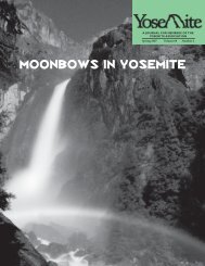
FOLLOWING YOSEMITE’S WILD<br />
AND SCENIC RIVERS<br />
Quick: Think of a <strong>Yosemite</strong> icon. Do you have one<br />
in mind Did you pick <strong>Yosemite</strong> Falls Maybe<br />
Half Dome or El Capitan Those are some obvious<br />
choices. But <strong>Yosemite</strong> National Park is home to two<br />
icons that are equally central to the park’s identity. Before<br />
there was a Half Dome or a Cathedral Peak, for the millennia<br />
when those iconic features were deep beneath a<br />
primordial sea floor, there was the river.<br />
Actually, rivers. <strong>Yosemite</strong> is home to two wild and<br />
scenic rivers, each with headwaters surrounded by federally<br />
protected wilderness. The park’s northern watershed<br />
drains into the Tuolumne, designated by Congress as a<br />
wild and scenic river in 1984. The Merced was designated<br />
in 1987 and contains the park’s southern watershed. Both<br />
of these tremendous waterways bisect <strong>Yosemite</strong> National<br />
Park over some 140 miles from the Sierra crest to the<br />
Sierra foothills.<br />
THE TUOLUMNE<br />
As seen from Tuolumne Meadows, the Tuolumne appears<br />
a peaceful sleeper of a river, meandering quietly through<br />
its meadow channel or sweeping in shallows over the<br />
granite river bottom. It spills forth from two mighty<br />
forks—the Dana and the Lyell.<br />
Between the shoulders of Mount Dana and Mount<br />
Gibbs, the Dana Fork emerges into Dana Meadows<br />
almost imperceptibly. It then careens along the Tioga<br />
Road, heralding the arrival to Tuolumne Meadows. The<br />
Lyell Fork of the Tuolumne is superlative in every way.<br />
It originates on Mount Lyell, <strong>Yosemite</strong>’s highest peak at<br />
13,114 feet in elevation. The mountain contains one of<br />
the Sierra’s last remaining glaciers, the Lyell Glacier. Here,<br />
the Lyell Fork starts as a trickle that can be straddled in<br />
places, flows into glacial pools and over granite benches<br />
and finally slows to a near crawl in Lyell Canyon as the<br />
river meanders through meadow bends punctuated by<br />
chutes and riffles.<br />
The forks meet in Tuolumne Meadows for a last<br />
gentle pass before plunging over a series of stair-step<br />
cascades to Glen Aulin and on to the Grand Canyon of<br />
the Tuolumne River and the Muir Gorge. From lush Pate<br />
Valley, the Tuolumne continues for trail-free miles to<br />
the mouth of Hetch Hetchy. Here, the congressionally<br />
designated portion of river corridor is interrupted,<br />
exempt from wild and scenic river status due to the<br />
impoundment created by O’Shaughnessy Dam. However,<br />
the wild and scenic river continues below the dam and<br />
through the Poopenaut Valley and slot canyons that few<br />
It takes an interdisciplinary team to create a long-term plan for managing a wild and scenic river. Here members of <strong>Yosemite</strong>’s Tuolumne<br />
planning team explore the river just above Glen Aulin.<br />
KRISTINA RYLANDS<br />
YOSEMITE ASSOCIATION, SPRING <strong>2008</strong><br />
3
![(March 1982) [PDF] “We Are Pleased to Announce†- Yosemite Online](https://img.yumpu.com/51299748/1/190x242/march-1982-pdf-aeuroewe-are-pleased-to-announceaeur-yosemite-online.jpg?quality=85)
![[PDF] Old Horny, Yosemite's Unicorn Buck - Yosemite Online](https://img.yumpu.com/51269869/1/184x260/pdf-old-horny-yosemites-unicorn-buck-yosemite-online.jpg?quality=85)
![1985 [PDF] - Yosemite](https://img.yumpu.com/48128837/1/184x260/1985-pdf-yosemite.jpg?quality=85)