Exploring - Severn Gorge Countryside Trust
Exploring - Severn Gorge Countryside Trust
Exploring - Severn Gorge Countryside Trust
- No tags were found...

You also want an ePaper? Increase the reach of your titles
YUMPU automatically turns print PDFs into web optimized ePapers that Google loves.
The <strong>Severn</strong> <strong>Gorge</strong> lies within the heart of<br />
this World Heritage Site designated for its<br />
history, geology and cultural heritage<br />
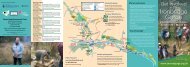
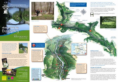
An overview of the <strong>Severn</strong> <strong>Gorge</strong>,<br />
showing the key sites managed<br />
by the <strong>Trust</strong><br />
<strong>Severn</strong> <strong>Gorge</strong> <strong>Countryside</strong> <strong>Trust</strong> works to balance the<br />
conservation and enhancement of landscape, wildlife and<br />
public access, and to reinforce the cultural importance of the<br />
special areas under its management.<br />
All of our landholdings are open to the public to explore and enjoy,<br />
and a network of waymarked paths and trails have been established<br />
through the woods and meadows of Ironbridge, Coalbrookdale,<br />
Jackfield, Coalport, Madeley, Barrow and Broseley.<br />
Interpretation panels have been installed for your benefit in<br />
some woodlands<br />
Walking in Sutton Wood<br />
<strong>Exploring</strong><br />
the <strong>Severn</strong> <strong>Gorge</strong><br />
Sutton Wood, the <strong>Trust</strong>’s most<br />
easterly parcel of land, has been little<br />
affected by past industrial activity. It is a<br />
Wildlife Site and one the richest in the<br />
<strong>Gorge</strong> for birds such as siskin, redpoll and<br />
whitethroat. It is also home to the scarce<br />
white-letter hairstreak butterfly.<br />
Enjoy a stroll with fabulous views on<br />
Haywood Pastures<br />
<strong>Severn</strong> <strong>Gorge</strong> <strong>Countryside</strong> <strong>Trust</strong> manages<br />
most of the woodland, grassland and other<br />
countryside within the Ironbridge <strong>Gorge</strong><br />
World Heritage Site, around 260 hectares<br />
(700 acres) in all, on a 999 year lease. The<br />
dramatic landscape of the <strong>Gorge</strong> is also<br />
a noted Conservation Area and includes<br />
a number of sites of national nature<br />
conservation importance.<br />
<strong>Exploring</strong> the <strong>Gorge</strong><br />
You are welcome to explore the historic landscape of the <strong>Severn</strong> <strong>Gorge</strong> along<br />
the network of paths and trails that thread their way through the <strong>Trust</strong>’s<br />
landholdings. While many of these follow public footpaths and bridleways,<br />
many are new paths that have been established and waymarked by the <strong>Trust</strong>.<br />
We have a continuous programme of upgrading the paths and<br />
if you encounter any difficulties while walking on our land,<br />
then please let us know by phoning the office on 01952 433<br />
880. A number of routes are fully described in a series of<br />
high-quality books and leaflets available from the Tourist<br />
Information Centre, Museums or the <strong>Trust</strong> Office, at a<br />
small cost, or free to download from our website.<br />
SGCT Publications<br />
Darby Road, Coalbrookdale<br />
Telford, TF8 7EP<br />
Tel: 01952 433880<br />
Email: staff@severngorge.org.uk<br />
Website: www. severngorge.org.uk<br />
REG. CHARITY NO. 1004508<br />
Designed by MA Creative www.macreative.co.uk<br />
Illustrated maps © SGCT, by Jeremy Pyke<br />
View looking east<br />
towards Coalport<br />
and Sutton Wood<br />
Haywood and Pastures<br />
is a complex of woodland and<br />
grassland above Coalport. With<br />
a south-facing aspect, walks<br />
across the open grassland can<br />
be glorious in the sunshine.<br />
Haywood was originally farmland,<br />
partially planted as woodland into<br />
1960s. In the 18C and 19C, when<br />
owned by the industrialist Darby<br />
family, hundreds of horses were<br />
reared here for use in the local<br />
industrial enterprises.<br />
Coalport was very much<br />
the inspiration of the ironmaster<br />
William Reynolds. The key to<br />
its success, as the seat of the<br />
china industry, lay in the canal/<br />
river interchange which he<br />
instigated in the late 18C. In<br />
1792 an astonishing engineering<br />
construction was developed<br />
called the Hay Incline Plane,<br />
still considered one of Britain’s<br />
foremost industrial monuments.<br />
Blists Hill<br />
Victorian Town<br />
To Madeley<br />
Coalport Bridge<br />
SILKIN WAY<br />
Hay Inclined<br />
Plane<br />
Tar Tunnel<br />
To Ironbridge<br />
SEVERN VALLEY WAY<br />
Coalport China Museum<br />
Memorial Bridge<br />
(FOOTBRIDGE)<br />
SEVERN VALLEY WAY<br />
Maws Craft Centre<br />
Jackfield Tile Museum<br />
Location of<br />
<strong>Severn</strong> <strong>Gorge</strong><br />
Holyhead<br />
A5<br />
A55<br />
Blackpool<br />
LIVERPOOL<br />
Chester<br />
Wrexham<br />
A5<br />
M6<br />
Crewe<br />
A53<br />
LEEDS<br />
M62<br />
MANCHESTER<br />
SHEFFIELD<br />
M1<br />
Stoke-on-Trent<br />
M6 Derby<br />
Nottingham<br />
A458 Shrewsbury Telford<br />
M54<br />
M6 Toll<br />
Leicester<br />
SEVERN GORGE Wovlerhampton<br />
A44<br />
A442<br />
BIRMINGHAM<br />
Aberystwyth<br />
Kidderminster<br />
Coventry A14<br />
Llandrindod Wells<br />
M42<br />
A49<br />
Northampton<br />
Worcester<br />
CAMBRIDGE<br />
M5<br />
Hereford M50<br />
M40<br />
M11<br />
M1<br />
Cheltenham<br />
A1(M)<br />
Abergavenny<br />
OXFORD<br />
M25<br />
Swansea<br />
M4<br />
CARDIFF<br />
Newport<br />
BRISTOL M4<br />
Reading<br />
LONDON<br />
M5<br />
M3 M25<br />
Disclaimer: The presence of a marked route or feature in this<br />
publication does not guarantee the existence or servicability on<br />
the ground, or any right of public access<br />
HULL<br />
Preenshead is the only<br />
land owned by the <strong>Trust</strong>.<br />
Records show this woodland<br />
to be very old and speciesrich<br />
with wild garlic, wood<br />
anemones, bluebell and the<br />
rare wood barley, all associated<br />
with old woodland. It has a<br />
relatively high population of<br />
breeding bullfinch.<br />
Getting involved<br />
<strong>Severn</strong> <strong>Gorge</strong> <strong>Countryside</strong> <strong>Trust</strong><br />
volunteering project involves local<br />
people who help the <strong>Trust</strong> maintain<br />
the woodland paths and meadows year<br />
round. Visitors are always welcome to<br />
take part.<br />
The project offers opportunities for people to get involved in all<br />
aspects of the <strong>Trust</strong>’s work, such as hedge-laying, path maintenance,<br />
infrastructure construction and monitoring. Tools, transport and<br />
training are provided and the activities are free, so join us for a different<br />
day out, get fit, learn new skills and contribute to the management of<br />
this very special area. Contact us for a programme or download it from<br />
our website: www.severngorge.org.uk<br />
Geology and landscape<br />
Shropshire has perhaps the richest geology of any county in Britain, and<br />
the Ironbridge <strong>Gorge</strong> is no exception. While it is better known as the<br />
‘Birthplace of Industry’, this would not have happened without a quirk<br />
of nature that exposed all of the necessary rocks and minerals in one,<br />
accessible place.<br />
At the end of the last Ice Age, weaknesses in the limestone provided an<br />
escape route for water trapped beneath an ice sheet. Under very high<br />
pressure, the water carved out the steep-sided gorge we see today, and<br />
in the process, exposed limestone, ironstone, sandstone, coal and clay.<br />
This process changed the course of the River <strong>Severn</strong> forever; previously,<br />
it had flowed north, now it flows south to Bristol.
Lydebrook Dingle woodland has the<br />
Lyde brook running through it and, being<br />
undisturbed for a long time, has the feel of<br />
the original ‘wildwood’ about it.<br />
View looking north – Coalbrookdale<br />
and Jiggers Bank<br />
View looking east towards<br />
Jackfield and Coalport<br />
Ropewalk and Wilderness Meadows<br />
are wonderful examples of traditional hay meadows<br />
and have possibly never seen artificial seeding or<br />
fertilisers. The soil’s low fertility ensures a wide<br />
biodiversity, with over a hundred different plant<br />
species regularly being recorded. In summer<br />
come ploughman’s spikenard, adders tongue fern<br />
and twayblade orchid, all of which are<br />
considered uncommon in Shropshire. It is<br />
also home to common spotted orchids and<br />
small heath butterflies.<br />
Sunniside Deer Park is a small, formal<br />
park laid out by the Darby family in the late<br />
18C. It lies behind the boundary brick wall to<br />
the west of Ropewalk meadow where veteran<br />
beech and limes still survive. Built in 2010,<br />
<strong>Severn</strong> <strong>Gorge</strong> <strong>Countryside</strong> <strong>Trust</strong>’s awardwinning<br />
building lies within the grounds.<br />
Loamhole Dingle is of national conservation<br />
importance, primarily because it supports specialist<br />
insects associated with the stream that flows<br />
through the ancient woodland.<br />
Captain’s Coppice was once traditionally coppiced for<br />
industrial and domestic purposes. In spring, the woodland<br />
floor is carpeted with the bright green foliage of wild garlic<br />
which later turns white with its many spiked flowers. Today,<br />
the lower area of the wood, leased to the Green Wood<br />
Centre, is coppiced once again to provide material for<br />
traditional crafts courses run by the Centre.<br />
Coalbrookdale which lies in a beautiful<br />
wooded valley is where Abraham Darby I revolutionised<br />
the smelting of iron using coke from coal in 1709, which<br />
means the area can lay claim to being one key seat of the<br />
industrial revolution which changed the world.<br />
A4169<br />
SHROPSHIRE WAY<br />
JIGGERS BANK<br />
SGCT Office<br />
Rosehill House<br />
Dale House<br />
Museum of Iron<br />
Coalbrookdale<br />
Arboretum<br />
Jiggers Roundabout<br />
Aga Factory<br />
A5223 To M54 (W)<br />
Woodside<br />
Community Orchard<br />
Darby’s Furnace<br />
Enginuity<br />
Wynnes, Vane Coppice and Jiggers Bank<br />
include ancient semi-natural woodland dominated by<br />
oak and a larch plantation established in the 1960s.<br />
History shows phases of woodland management,<br />
farming, and industry such as The Old Wynd inclined<br />
plane in Vane Coppice.<br />
A4169<br />
Church Road<br />
Fields<br />
Museum of<br />
Steel Sculpture<br />
Oilhouse Coppice adjoins<br />
Rough Park, a landscaped area<br />
formerly of open-cast clay workings<br />
and now a wild species-rich meadow.<br />
CHERRY TREE HILL<br />
Rough Park<br />
To M54 (E)<br />
To Madeley<br />
Dale Coppice Dale Coppice has seen<br />
woodland cover since at least the 13C when<br />
it was part of the estates of Wenlock Priory.<br />
It became noted for its early public walks,<br />
the Sabbath Walks, laid out by the Quaker<br />
ironmaster and philanthropist Richard<br />
Reynolds in 1780s. Dale Coppice<br />
is ancient semi-natural woodland<br />
dominated by sessile oak and beech.<br />
Lloyds Coppice experienced a period of intense<br />
industrial activity focussing on ironstone mining and clay<br />
extraction. The woodland contain ponds, rare<br />
wetland habitats in a woodland setting, which<br />
can support populations of great-crested newts, a<br />
species of European-wide conservation importance.<br />
Blists Hill<br />
Victorian Town<br />
SILKIN WAY<br />
Free Bridge<br />
Hay<br />
Inclined Plane<br />
Bedlam Furnaces<br />
Coalport<br />
Community<br />
Orchard<br />
Tar Tunnel<br />
SEVERN VALLEY WAY<br />
Memorial Bridge<br />
(FOOTBRIDGE)<br />
Maws Craft Centre<br />
Jackfield Tile Museum<br />
Coalport Bridge<br />
Coalport China Museum<br />
Jackfield is a fascinating area<br />
made up of a series of very ancient<br />
neighbourhoods with wonderful names<br />
like The Tuckies, Salthouses and The<br />
Werps, reflecting its long working past<br />
from fishing, pottery, iron making and<br />
clay industries of brick, roof tiling and<br />
decorative tiles.<br />
To Broseley<br />
Ladywood has an industrial past<br />
which has left a legacy of collapsed<br />
shafts, spoil heaps, mounds and tracks<br />
which has left it difficult to access.<br />
Rowing Club<br />
Green Wood<br />
Centre<br />
DALE ROAD<br />
The Rotunda<br />
Museum of the <strong>Gorge</strong><br />
Lincoln Hill offers one of the finest views of the<br />
Iron Bridge from a point known as the Rotunda enjoying<br />
panoramic views of the surrounding countryside. The edifice,<br />
built there in 1790s, had cast iron pillars, a domed roof and a<br />
revolving seat, but was demolished in 1804, possibly due to<br />
instability of the nearby limestone quarry face. Lincoln Hill is<br />
today a Site of Special Scientific Interest, an area of<br />
national importance for its geology. It is composed<br />
of limestone, an uplifted sea-bed formed 420 million<br />
years ago when Ironbridge lay near the Equator!<br />
The Crostan was once a former<br />
pitmound of mining waste (the name<br />
derives from craw-waste and stanstone).<br />
It is one of the few <strong>Gorge</strong><br />
woodlands where pine is the principal<br />
tree species. The Scots pine and<br />
Corsican pine trees date back to the<br />
1930s, an era of significant hardship<br />
and unemployment. A small and<br />
important area of heathland occurs at<br />
the southern end of the Crostan, where<br />
plants such as heather and bilberry are<br />
to be found, as well as the occasional<br />
reptile, such as adder.<br />
SEVERN VALLEY WAY<br />
Iron Bridge<br />
The Toll House<br />
SHROPSHIRE WAY<br />
SEVERN VALLEY WAY<br />
Iron Bridge<br />
The Toll House<br />
Bower Yard lime kiln, situated on the<br />
<strong>Severn</strong> Valley Way, was worked until<br />
1940s. The kiln was fed with coal and<br />
crushed limestone to make quick lime<br />
used in building and agriculture.<br />
Ironbridge alongside the River <strong>Severn</strong> lies<br />
at the heart of the World Heritage Site which is<br />
the Ironbridge <strong>Gorge</strong>, where the famous bridge<br />
was constructed in 1779 by Abraham Darby III. It<br />
has good car parking and a range of shops, cafes,<br />
a museum, accommodation and facilities.<br />
Benthall Edge Wood<br />
was, until the early 20C, the<br />
scene of major industrial activity<br />
with visual evidence of former<br />
quarries, mineshafts, adits,<br />
lime kilns, inclined planes and<br />
tramways. It is now a Site of<br />
Special Scientific Interest (SSSI),<br />
an area of national conservation<br />
importance. The wood<br />
is also home to one of<br />
Britain’s rarest trees,<br />
the large-leaved lime.<br />
Workhouse Coppice is managed by the<br />
<strong>Trust</strong> on lease from the Woodland <strong>Trust</strong> and adjoins<br />
Benthall Edge Wood. It is nationally important for its<br />
remains of bell-pits, relatively shallow pits once used<br />
to extract coal from below the surface. The canopy<br />
is mainly oak, with a holly under-storey and carpeted<br />
with wood anemone in spring.<br />
Footpaths marked here<br />
are indicative only –<br />
for more information<br />
see the <strong>Trust</strong>’s range of walks<br />
publications (see back page)<br />
or refer to Ordnance Survey<br />
Explorer 242 map.<br />
Some sites are on steep, uneven<br />
ground so come prepared.<br />
Key to Maps<br />
Long-distance Footpath<br />
Recomended routes<br />
Walks Start Point<br />
Cycle Parking<br />
Car Parking<br />
Visitor Information Centre<br />
Places of Interest<br />
Viewpoint<br />
Museum<br />
Bus Stop<br />
Public House<br />
Youth Hostel<br />
Public Toilets<br />
Picnic Area<br />
Café/Restaurant<br />
Shops<br />
Cash Point