Oil Spill Detection - Simrad Professional Series
Oil Spill Detection - Simrad Professional Series
Oil Spill Detection - Simrad Professional Series

Create successful ePaper yourself
Turn your PDF publications into a flip-book with our unique Google optimized e-Paper software.
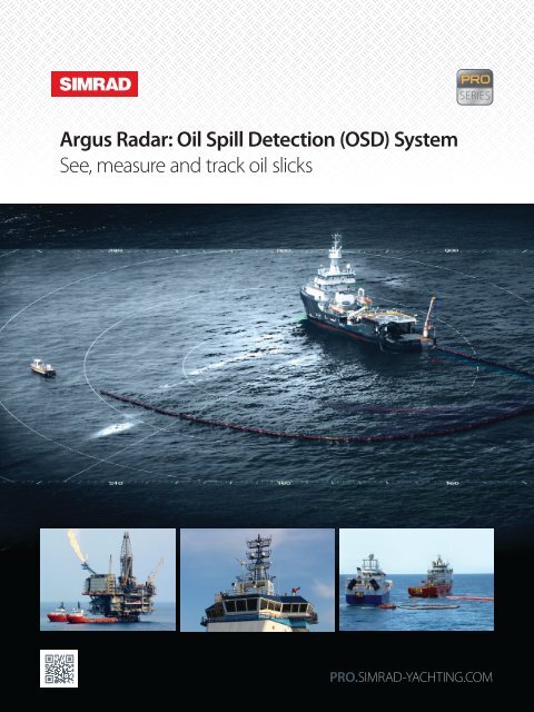
Argus Radar: <strong>Oil</strong> <strong>Spill</strong> <strong>Detection</strong> (OSD) System<br />
See, measure and track oil slicks
2<br />
<strong>Oil</strong> spill detection, response and recovery<br />
Early detection<br />
Early detection and the ability to mount an emergency response<br />
are essential should an oil spill occur. <strong>Oil</strong> spills are costly to the<br />
environment and the maritime industry, so oil spill prevention,<br />
detection and recovery are paramount.<br />
Having dedicated equipment permanently installed on your<br />
vessel that will allow you to accelerate the clean-up operation<br />
and contain the contaminated area is a necessity. The <strong>Simrad</strong><br />
ARGUS Radar <strong>Oil</strong> <strong>Spill</strong> <strong>Detection</strong> application is a must have, and<br />
this is a simple add-on to our standard type approved IMO/SOLAS<br />
navigational radar. The advanced hardware video processing<br />
function enables the detection and tracking of oil slicks.<br />
On-board with <strong>Simrad</strong> ARGUS<br />
The <strong>Simrad</strong> Argus <strong>Oil</strong> <strong>Spill</strong> <strong>Detection</strong> application works by receiving<br />
and processing signals in real-time from on-board transceivers.<br />
The water surface is usually dampened when it is contaminated<br />
by oil, so the backscatter of microwave radiation from these waves<br />
is unlike the rest of the sea. The radar is then able to highlight the<br />
dampening of the reflected microwave radiation on the radar<br />
display, thus calculating the size, position and drift (speed and<br />
course) of the oil spill. We let you see inside the oil spill!<br />
Looking inside the oil slick with your standard<br />
navigational radar<br />
Ships in regular operations can use the primary radar set as a<br />
traditional instrument for navigation, and the secondary radar<br />
display (interfaced to the primary radar) switched over to the<br />
advanced function of <strong>Oil</strong> <strong>Spill</strong> <strong>Detection</strong>. We are among the first<br />
companies in the world to provide an oil detection application<br />
working in parallel with its IMO/SOLAS ARPA navigational radar.<br />
From the ship owners’ point of view, the most important benefit is<br />
the reduced maintenance costs in terms of installation, service and<br />
spare parts. In addition, the officers on watch don’t have to learn a<br />
new operating system, because the OSD functionality is part of the<br />
standard navigational radar system with the same user interface.<br />
The <strong>Simrad</strong> ARGUS <strong>Oil</strong> <strong>Spill</strong> <strong>Detection</strong> radar operates on the same<br />
hardware (not PC based) approved by the Federal Maritime and<br />
Hydrographic Agency in Germany (BSH), and is compliant with the<br />
European Maritime Directive (MED) and United Stated Coast Guard<br />
regulations. In a combined and integrated navigation and oil spill<br />
response and management bridge system, the stress of the officers<br />
on duty is drastically reduced by operating on the same userfriendly<br />
graphical man-machine interface.<br />
Long heritage and global support<br />
With over 60 years at the forefront of product innovation, we are<br />
one of the world’s most recognised brands in the field of marine<br />
electronics. This heritage provides a platform from which some of<br />
the most innovative products are engineered. Our OSD application<br />
is one that you can depend on to improve oil spill response<br />
capabilities, and should the need arise, our global service network<br />
of support engineers located in over 50 key ports around the world<br />
will deliver first class on-board service.<br />
Deepwater Horizon Response<br />
<strong>Professional</strong> <strong>Series</strong><br />
<strong>Oil</strong> <strong>Spill</strong> <strong>Detection</strong> Radar Systems
<strong>Oil</strong> spill detection features<br />
3<br />
Main <strong>Oil</strong> <strong>Spill</strong> <strong>Detection</strong> Features<br />
uu<br />
uu<br />
uu<br />
uu<br />
uu<br />
uu<br />
uu<br />
Ability to present oil concentration/thickness inside the<br />
oil slick pattern<br />
Automatic oil spot contour detection and area size<br />
calculation<br />
Assessment of the oil slick position, speed and direction<br />
Data recording of the operating history and instant<br />
screen dumps<br />
Instrumental maximum oil spill detection range up to<br />
12 Nm<br />
Real-time processed images with selectable integration<br />
time between 30 seconds up to 2 minutes<br />
Information display about wind conditions<br />
uu<br />
Ability to increase the antenna rotation speed up to 44<br />
revolutions per minute<br />
uu<br />
uu<br />
uu<br />
uu<br />
uu<br />
uu<br />
Ability to integrate external sensors and devices<br />
Capacity to interface and receive signals from two radar<br />
sensors and allows the operator to select the transceiver<br />
to be used for <strong>Oil</strong> <strong>Spill</strong> <strong>Detection</strong>.<br />
Option to add an additional two radar sensors dedicated<br />
for oil spill<br />
Full master/slave interwsitchability with two additional<br />
navigational radar plants<br />
Superb video processing with 256 multicolour video<br />
levels providing sharp colour distinctions on screen<br />
System also provides special features such as Ice<br />
detection and Navigation mode, Small Target <strong>Detection</strong><br />
mode and Meteorology mode for storm tracking<br />
The OSD application shares the same hardware as the<br />
IMO/SOLAS APRPA navigational radar plant.<br />
Incorporate information about wind conditions to assist with<br />
oil slick speed and direction calculations.<br />
Look inside the oil slick with 256 multicolour video levels.<br />
Water contaminated by oil: low density = blue, high density = red<br />
Seamless interswitching between navigational and OSID radars.<br />
<strong>Professional</strong> <strong>Series</strong><br />
<strong>Oil</strong> <strong>Spill</strong> <strong>Detection</strong> Radar Systems
4<br />
How the Argus <strong>Oil</strong> <strong>Spill</strong> <strong>Detection</strong> software works<br />
How it works<br />
In general, the operation of the marine radar is based on the<br />
physical phenomenon of backwards “scattering” of microwave<br />
radiation. When the microwave radiation waves strike an object,<br />
they are reflected in all directions. The signal is also partially<br />
radiated back towards the direction of origin (backscattering),<br />
generating an echo on the radar display. The wind causes the<br />
regular rise and fall of the water level: the sea waves.<br />
The presentation on the navigational radar screen is affected by<br />
the presence of the waves. The waves seen by a radar appear as<br />
an immeasurable amount of reflective objects that radiate back<br />
microwave energy in a completely chaotic and incoherent way<br />
over 360 degrees for several miles. The navigational radar has<br />
countermeasures to reduce this disturbance caused by waves and<br />
makes visible the possible targets.<br />
For the <strong>Oil</strong> <strong>Spill</strong> <strong>Detection</strong> functionality it is vice versa. Echoes<br />
from particular waves are required. Ripples, called capillary waves,<br />
appear on smooth water when the wind blows due to the friction<br />
of air flowing over the sea surface.<br />
The echoes from the sea surface, in terms of microwave radiation,<br />
meet the law of the surface reflectivity.<br />
The microwave radiation reflectivity<br />
depends on the angle of incidence, the<br />
roughness and the dielectric constant<br />
properties of the sea surface. The<br />
suppression of the capillary waves by oil<br />
viscosity reduces the surface roughness.<br />
The different dielectric constant of the oil<br />
results in less radar backscatter.<br />
The returning signal from an area contaminated by oil is slightly<br />
dampened by both of these factors working simultaneously.<br />
The excellent capability of the <strong>Simrad</strong> Argus <strong>Oil</strong> <strong>Spill</strong> <strong>Detection</strong><br />
radar, thanks to an advanced real-time signal processing, is able to<br />
highlight the dampening of the reflected microwave radiation on<br />
the radar display.<br />
Vertical Polarization Antennas<br />
When discussing microwave energy propagation and scattering,<br />
the polarization of the radiation is an important property.<br />
Although imagery in both vertical and horizontal polarizations<br />
can be used for slick detection, the vertical imagery is preferred<br />
for dedicated oil spill radar sensors. In general, it offers a stronger<br />
clutter background than other polarization choices, generating an<br />
improved contrast with the oil contaminated areas.<br />
However, in spite of the fact that vertical polarizations are more<br />
sensitive than horizontal for slick detection, there are only<br />
disadvantages in their use for navigational radars.<br />
<strong>Simrad</strong> Argus OSD display is available in three different configurations to suit any vessel:<br />
The deck configuration provides an<br />
optional display deck stand which can<br />
also house the electronic cabinet.<br />
Two different options available :<br />
• Desk-Top Cabinet for 26“ with Pedestal<br />
• Desk-Top Cabinet for 23“ / Adapter<br />
Frame kit for 19” Monitor / Pedestal<br />
The modular configuration with<br />
monitor, keyboard and ARPA electronic<br />
cabinet supplied as three separate<br />
modules which can be flush mounted<br />
into the bridge console to the customers´<br />
preference.<br />
The table top configuration where<br />
the monitor and key-board are housed<br />
into an ergonomic console while the<br />
electronics are contained in a separate<br />
bulkhead mounted cabinet.<br />
<strong>Professional</strong> <strong>Series</strong><br />
<strong>Oil</strong> <strong>Spill</strong> <strong>Detection</strong> Radar Systems
Looking inside the oil slick<br />
5<br />
Vessels towing oil recovery<br />
booms into place<br />
Spot area of oil<br />
concentration<br />
<strong>Oil</strong> spot area =<br />
10.38km2<br />
<strong>Oil</strong> volume =<br />
326,592 barrels<br />
<strong>Oil</strong> thickness = 5mm<br />
Vessel spilling oil<br />
Spot contour<br />
showing outline<br />
of oil spill<br />
Colour gradients to<br />
show oil density<br />
<strong>Professional</strong> <strong>Series</strong><br />
<strong>Oil</strong> <strong>Spill</strong> <strong>Detection</strong> Radar Systems
6<br />
System diagrams<br />
Navigation and oil response Bridge Solution<br />
X Band Antenna Group<br />
X Band<br />
6 and 9 Ft<br />
12 or 25 kW<br />
and HSC<br />
Additional two radar sensors<br />
for oil spill (optional)<br />
Navigation Radar<br />
<strong>Oil</strong> <strong>Spill</strong> Radar<br />
2nd Station<br />
Interswitch<br />
Bridge Network (Lan)<br />
to ECDIS<br />
interfaced to OTHER RADAR BRAND<br />
BASIC SOLUTION<br />
Existing X Band Radar System<br />
X Band Antenna Group<br />
ALPHA RIB<br />
(Radar Interface Board)<br />
X Band<br />
<strong>Oil</strong> <strong>Spill</strong> <strong>Detection</strong> Radar Display<br />
<strong>Oil</strong> <strong>Spill</strong> <strong>Detection</strong> Radar Display<br />
<strong>Professional</strong> <strong>Series</strong><br />
<strong>Oil</strong> <strong>Spill</strong> <strong>Detection</strong> Radar Systems
Technical specifications<br />
<strong>Oil</strong> <strong>Spill</strong> <strong>Detection</strong> operational mode<br />
7<br />
Display<br />
Monitors<br />
Radar picture<br />
Resolution<br />
19” LCD TFT<br />
23” LCD TFT<br />
27” LCD TFT<br />
>250 mm (12” PPI)<br />
>320 mm (16” PPI)<br />
1280x1024<br />
1600x1200<br />
Day/Night modes<br />
Head, Course and North Up<br />
Course and North Up<br />
Up to 50% of range scales in use<br />
0.25; 0.5; 0.75; 1.5; 3; 6; 12 nm<br />
3 m on 0.75 nm range scale<br />
Presentation modes<br />
Relative motion (RM)<br />
True motion (TM)<br />
Off-centering<br />
Range scales<br />
Range resolution<br />
Azimuth resolution 0.1°<br />
Trackball<br />
Polar and Geographical coordinates<br />
continuously displayed<br />
Diagnostic<br />
On-line diagnostic programs<br />
<strong>Oil</strong> slick tracking facilities<br />
Acquisition<br />
Manual<br />
Tracking<br />
Manual with automatic dead-reckoning<br />
Operating history<br />
UTC, Range/Bearing, Speed/Course,<br />
Latitude/Longitude, Area, Volume and<br />
Thickness. Transferable via USB<br />
Memory stick or network.<br />
<strong>Oil</strong> slick vectors<br />
Four time integration filters<br />
Metric measurement of oil<br />
OSD threshold<br />
<strong>Oil</strong> slick contour<br />
Search mode<br />
Anchored mode<br />
Spot area<br />
Volume<br />
<strong>Oil</strong> thickness<br />
Data recording<br />
AIS facilities<br />
Presentation<br />
Safe checking<br />
Auto acquisition/<br />
Guard zones<br />
Visualize the potential vectors of patches of<br />
oil<br />
The longer the filter length, the more evident<br />
the presence of oil will be<br />
Choose between Nautic or Metric units of<br />
measurement<br />
Modify the video color palette threshold<br />
within the monitoring window of the oil<br />
patch for more accurate calculation of the<br />
surface area of the patch<br />
Highlights the outline of the oil slick<br />
The monitoring window maintains its position<br />
relative to the ship<br />
The oil spill monitoring window will remain<br />
anchored at its true geographical position<br />
Expressed in m2/km. Spot area indicates the<br />
surface of the oil patch<br />
Presumed volume of oil expressed in barrels<br />
Manual setting of presumed thickness of oil<br />
patch for greater accuracy in calculating the<br />
volume of oil<br />
The following oil patch area data can be<br />
recorded -area, date and time, geographical<br />
position of the patch barycentre, speed and<br />
direction<br />
Up to 300 targets chosen as the nearest to<br />
own ship<br />
All 300 targets in sleep or activated stated<br />
Same zones as described for ARPA facilities<br />
Mapping<br />
Operator compiled maps up to 120 segments plus symbols and text strings<br />
with selectable colours and line styles.<br />
Map stabilisation<br />
Relative, true (Dead Reckoning) or<br />
geographic<br />
Map storage<br />
By Name , on a built-in non volatile<br />
memory.<br />
Transferable via USB Memory stick<br />
Map adjustment<br />
Position and Orientation<br />
Graphic functions<br />
Alarms<br />
Data readout<br />
OSD target data<br />
AIS target data<br />
Own ship data<br />
<strong>Oil</strong> spill area<br />
<strong>Oil</strong> spot volume<br />
System setting<br />
True or relative time adjustable vectors<br />
Target identification number, track-ball<br />
marker and true marks.<br />
AIS identification number, ship names or<br />
call signs.<br />
Time adjustable past position plots<br />
Own ship shape and activated AIS target<br />
shape on lower range scales.<br />
Range/Bearing, Speed/Course and<br />
Latitude/Longitude.<br />
Ship Name, MMSI, Call Sign, Range/<br />
bearing, speed/course, CPA/TCPA and<br />
Latitude/Longitude, Type, Status,<br />
Destination, ETA, ship size, AIS class.<br />
Heading, Speed/Course water or ground<br />
stabilized, wind speed and direction, Geo<br />
graphic position and UTC time.<br />
Automated calculation of the oil spot area<br />
in Km² or m².<br />
Computed calculation of the oil spot<br />
volume in barrels.<br />
<strong>Oil</strong> Slick Thickness.<br />
Alarms<br />
Acoustic and visual warning for: System and<br />
external interface sensors (EPFS and AIS)<br />
failures.<br />
Inputs<br />
Gyro heading<br />
Analog, synchro or stepper<br />
Digital Fast NMEA (IEC 61162-2)<br />
Speed log<br />
Analog: PIT or two axis log<br />
Digital: NMEA (IEC 61162-1)<br />
EPFS Serial Interface NMEA (IEC 61162-1)<br />
Wind Serial Interface NMEA (IEC 61162-1)<br />
AIS Serial Interface NMEA (IEC 61162-1)<br />
Output Serial Interface NMEA 0183 (IEC 61162-1)<br />
RATTM - RAOSD – RARSD – RAALR –<br />
RATLB – RATTD sentences<br />
Four USB 2.0 port.<br />
Rules references<br />
Type testing in IMO Resolution A.813 (19), accordance with A.694 (17),<br />
MSC192 (79), MSC 36 (63), IMO Circ. S/N 217<br />
and specified standards:<br />
IEC 60945 (General Requirements)<br />
IEC 62388 (Performance Requirements)<br />
IEC 61162-1/2 (NMEA Interface)<br />
X-Band Radar Up-mast<br />
Peak Power (kW) 12 or 25<br />
Pulse length (nsec) 60 – 250 - 800<br />
PRF (Hz) 3000-1500-750<br />
Antenna model 6X 9X 12X<br />
Gain (dB) 29 31 32,5<br />
Horizontal beam width at -3 dB (°) 1,3 0,9 0,7<br />
Vertical beam width at -3 dB (°) 22 22 22<br />
Weight of Antenna (kg) 40 44 49<br />
(incl. Pedestal with Transceiver)<br />
Nominal Rotation speed (RPM) 22 or 44<br />
Environmental Options<br />
Different PRF set:<br />
Upon Customer request<br />
Heaters: For very cold environment (< -25° C)<br />
<strong>Professional</strong> <strong>Series</strong><br />
<strong>Oil</strong> <strong>Spill</strong> <strong>Detection</strong> Radar Systems
OUR Heritage: ESTABLISHED IN 1947.<br />
With more than 60 years of maritime expertise invested in delivering solutions to the<br />
professional market, we have unique knowledge to support professional customers<br />
with cost effective navigation solutions.<br />
Contact us:<br />
Navico Americas: Tel: +1 832 377 9578 Email: sales.americas@navico.com<br />
Navico Asia Pacific: Tel: +64 9 925 4500 Email: sales.apacnz@navico.com<br />
Navico EMEA: Tel: +44 1794 510010 Email: sales.emea@navico.com<br />
985-10557-001