Public Spaces | Public Life for Seattle's South Downtown
Public Spaces | Public Life for Seattle's South Downtown
Public Spaces | Public Life for Seattle's South Downtown

Create successful ePaper yourself
Turn your PDF publications into a flip-book with our unique Google optimized e-Paper software.
Past + Future<br />
Early <strong>South</strong> Seattle<br />
Long be<strong>for</strong>e the Euro-American settlers arrived in the Pacific Northwest, the Coastal Salish<br />
people had developed a complex culture based on fishing, hunting and gathering around<br />
the area of present day Seattle. In 1853, the south downtown area saw the beginning of the<br />
Northwest’s first commercial enterprise, Henry Yesler’s sawmill, which was constructed on the<br />
downtown waterfront in 1853. The first transcontinental railroad was completed in 1869 and<br />
in 1883 the city finally achieved connection to national rail lines at the south end of the city.<br />
Thereafter the surrounding area slowly grew to serve as the city’s center of commerce and<br />
industry.<br />
In the mid 1960s, the preservation movement began to take hold, and the first historic district<br />
in the city was created in Pioneer Square. In the 1970s, this set up regional guidelines <strong>for</strong> the<br />
preservation, rehabilitation and conservation <strong>for</strong> development around historic districts, and the<br />
area became a popular region <strong>for</strong> tourism and entertainment. Now, with the additions of the<br />
sports stadiums, rehabilitation of two train stations and light rail station, and new residential<br />
developments, this district in <strong>South</strong> <strong>Downtown</strong> is seeing a resurgence of population and activity.<br />
With careful attention to its rich natural, cultural and architectural history alongside sustainable<br />
urban growth, the area can be a place thriving with public spaces <strong>for</strong> a rich public life.<br />
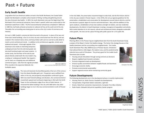
On June 6, 1889, Seattle’s commercial district burned to the ground. In place of the two and<br />
three-story wood buildings, a four to six story city was constructed over the old city, and was<br />
created in fire-resistant stone, brick, and heavy timber with cast iron and terra cotta detail to<br />
match current architectural trends. In addition to the architectural upgrades, streets were<br />
widened and paved. A thorough regrade of the<br />
downtown area made an interesting temporary<br />
underground area from the old street grade, but<br />
also built functional water and sewer systems. In<br />
certain areas, the first floor of the old city was<br />
placed directly underneath the new modern city,<br />
creating an ‘underground Seattle’ that stayed in<br />
use <strong>for</strong> years as a shopping area and additional<br />
commercial space. Soils from the regrade provided<br />
Aftermath 1889 Fire<br />
fill to trans<strong>for</strong>m the expansive tidelands into<br />
source: University of Washington Special Collections<br />
buildable spaces.<br />
Underground Seattle<br />
The new and improved city benefited greatly at the turn of the century<br />
from the Alaska Klondike gold rush. Prospectors were outfitted from<br />
sellers in the city, and prosperity and population continued to grow.<br />
With new steel framed buildings and elevators, the commercial district<br />
moved both upward and northward, beginning in 1914 with the Smith<br />
Tower on the northeastern edge of our site on Yesler Avenue. It<br />
remained the tallest building in the city until 1969 when new, taller<br />
buildings began to rise in the new commercial district north of Pioneer<br />
Square.<br />
Future Plans<br />
Planning ef<strong>for</strong>ts in the Pioneer Square neighborhood stem from the <strong>South</strong> <strong>Downtown</strong> Study,<br />
a project of the Mayor’s Center City Seattle strategy. The Center City strategy focuses on the<br />
Seattle downtown and the surrounding nine neighborhoods. The Livable<br />
<strong>South</strong> <strong>Downtown</strong> Plan, May 2008 focuses on Pioneer Square, Chinatown/<br />
International District, Little Saigon, the stadium area, and the predominantly<br />
industrial area south of Chinatown. The primary goals <strong>for</strong> the Livable <strong>South</strong><br />
<strong>Downtown</strong> plan include:<br />
• Housing and job stimulation through zoning and land use decisions<br />
• Respect neighborhood character and plans<br />
• Promote integrated mixed-use development<br />
• Enhance quality connections between neighborhoods and downtown<br />
Dumpster Free Alley<br />
• Encourage economic vitality<br />
• Promote environmental sustainability<br />
• Support regional services while maintaining community goals<br />
Future Developments<br />
The following developments are in the development phase or recently implemented.<br />
• Housing: North Lot, Yesler Terrace, Goodwill site developments<br />
• Transportation: King Street Station restoration, Light Rail<br />
• Streets: Waterfront connection improvements, Dumpster-Free Alley Initiative<br />
• <strong>Public</strong> Realm: Sidewalk Cafe permit expedition, Busker program<br />
ANALYSIS<br />
King Street Station<br />
<strong>Public</strong> <strong>Spaces</strong> | <strong>Public</strong> <strong>Life</strong> <strong>for</strong> Seattle’s <strong>South</strong> <strong>Downtown</strong><br />
Pg 5