January 21, 2011 Utility Meeting - Maine GIS User Group
January 21, 2011 Utility Meeting - Maine GIS User Group
January 21, 2011 Utility Meeting - Maine GIS User Group

You also want an ePaper? Increase the reach of your titles
YUMPU automatically turns print PDFs into web optimized ePapers that Google loves.
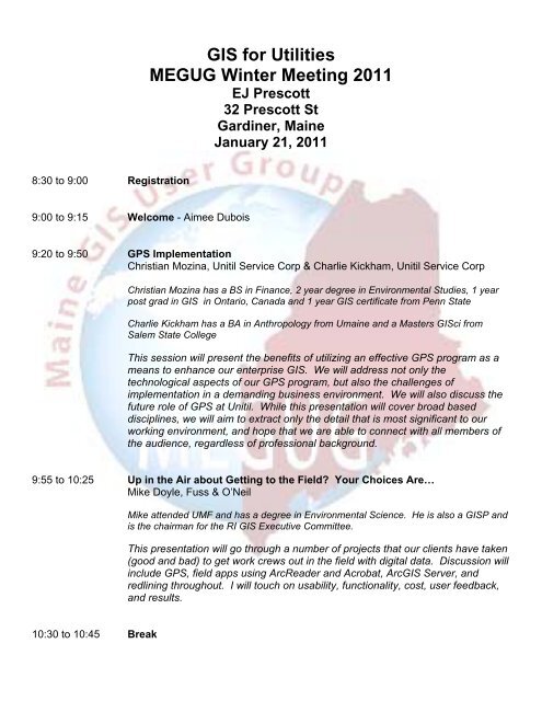
<strong>GIS</strong> for Utilities<br />
MEGUG Winter <strong>Meeting</strong> <strong>2011</strong><br />
EJ Prescott<br />
32 Prescott St<br />
Gardiner, <strong>Maine</strong><br />
<strong>January</strong> <strong>21</strong>, <strong>2011</strong><br />
8:30 to 9:00 Registration<br />
9:00 to 9:15 Welcome - Aimee Dubois<br />
9:20 to 9:50 GPS Implementation<br />
Christian Mozina, Unitil Service Corp & Charlie Kickham, Unitil Service Corp<br />
Christian Mozina has a BS in Finance, 2 year degree in Environmental Studies, 1 year<br />
post grad in <strong>GIS</strong> in Ontario, Canada and 1 year <strong>GIS</strong> certificate from Penn State<br />
Charlie Kickham has a BA in Anthropology from Umaine and a Masters <strong>GIS</strong>ci from<br />
Salem State College<br />
This session will present the benefits of utilizing an effective GPS program as a<br />
means to enhance our enterprise <strong>GIS</strong>. We will address not only the<br />
technological aspects of our GPS program, but also the challenges of<br />
implementation in a demanding business environment. We will also discuss the<br />
future role of GPS at Unitil. While this presentation will cover broad based<br />
disciplines, we will aim to extract only the detail that is most significant to our<br />
working environment, and hope that we are able to connect with all members of<br />
the audience, regardless of professional background.<br />
9:55 to 10:25 Up in the Air about Getting to the Field Your Choices Are…<br />
Mike Doyle, Fuss & O’Neil<br />
Mike attended UMF and has a degree in Environmental Science. He is also a <strong>GIS</strong>P and<br />
is the chairman for the RI <strong>GIS</strong> Executive Committee.<br />
This presentation will go through a number of projects that our clients have taken<br />
(good and bad) to get work crews out in the field with digital data. Discussion will<br />
include GPS, field apps using ArcReader and Acrobat, Arc<strong>GIS</strong> Server, and<br />
redlining throughout. I will touch on usability, functionality, cost, user feedback,<br />
and results.<br />
10:30 to 10:45 Break
10:50 to 11:50 Leveraging your existing <strong>GIS</strong> system for Infrastructure Asset Management<br />
Alex H. von Svoboda, VUEWorks Inc.<br />
Mr. von Svoboda joins VUEWorks from Autodesk, where he spent over eleven years in<br />
sales management for North America. Prior to Autodesk, Mr. von Svoboda was the<br />
Managing Director for Softdesk Europe, a civil and architectural engineering CAD<br />
software development company. He holds a Civil Engineering degree from Ryerson<br />
University.<br />
This session will talk about the current trends in the municipal marketplace<br />
requiring a web based work/asset management solution that can be applied<br />
holistically throughout the municipality, supporting the increased demands for<br />
CMOM, NPDES, MUTCD sign retro-reflectivity and GASB 34 reporting. This<br />
session will also look at how Web based technology, mobile hardware and<br />
wireless communication has evolved to allow towns, cities and utilities bring <strong>GIS</strong><br />
map based information to anyone, anywhere and anytime. Customer case<br />
studies will also be reviewed that describe the transition from a paper based work<br />
flow to a digital <strong>GIS</strong> centric environment; providing a rich foundation of<br />
information to make informed decisions on asset maintenance, refurbishment<br />
and ultimately replacement.<br />
12:00 to 1:00 Lunch<br />
1:10 to 1:40 Common Operating Picture for <strong>Utility</strong> Outages<br />
Christopher Kroot, <strong>Maine</strong> Office of <strong>GIS</strong><br />
Christopher is an Enterprise <strong>GIS</strong> Analyst for the <strong>Maine</strong> Office of <strong>GIS</strong><br />
This talk will be on the Common Operating Picture (COP) that the State of <strong>Maine</strong><br />
is implementing. I will discuss the objectives of the <strong>Maine</strong> Public <strong>Utility</strong><br />
Commission in regards to monitoring the outage information, how they plan on<br />
using the COP during an outage situation, how the COP will effect outage data<br />
capture, transfer, and maintenance. I will also touch on the objectives of the<br />
<strong>Maine</strong> Emergency Management Agency and how they will use the COP in an<br />
emergency, the COP as a planning tool, the stakeholders, and the products and<br />
services provided. The COP uses Google Earth Enterprise, ESRI ArcServer and<br />
SDE, WebEOC, Mobile devices, and custom programs. I will also discuss the<br />
Road Ahead and hope to do a short demo.<br />
1:45 to 2:15 On Target <strong>Utility</strong> Screening with the aid of <strong>GIS</strong><br />
Matthew Caron, On Target <strong>Utility</strong> Services<br />
Matthew has a B.S. in Information Systems and 8 years in the <strong>Utility</strong> Industry.<br />
A discussion of underground utility screening services provided by On Target<br />
<strong>Utility</strong> services, leveraging integration of <strong>Utility</strong> <strong>GIS</strong> data sets to provide Dig Safe<br />
Ticket timely and reliable screening services for On Target <strong>Utility</strong> Services<br />
Clients.
2:20 to 2:35 Break<br />
2:40 to 3:40 Chapter 140 Regulations Panel Discussion<br />
Amy Spelke – Public <strong>Utility</strong> Commission<br />
Greg Jalbert – Auburn Water District<br />
Christian Mozina – Unitil Service Corp<br />
Fletcher Kittredge – GWI<br />
This Rule requires certain public utilities to develop, maintain, and file with the<br />
Commission maps of their service area and key infrastructure. This Rule further<br />
establishes standards for the content and format of those maps.<br />
3:45 to 4:00 Wrap-up