ACCRINGTON - Lancashire County Council
ACCRINGTON - Lancashire County Council
ACCRINGTON - Lancashire County Council
You also want an ePaper? Increase the reach of your titles
YUMPU automatically turns print PDFs into web optimized ePapers that Google loves.
<strong>Lancashire</strong> Historic Town Survey<br />
Accrington<br />
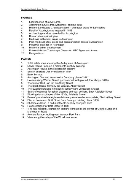
FIGURES<br />
1. Location map of survey area<br />
2. Accrington survey area with (inset) contour data<br />
3. Historic Landscape Characterisation – character areas for <strong>Lancashire</strong><br />
4. Detail of Accrington as mapped in 1848<br />
5. Archaeological sites recorded for Accrington<br />
6. Roman sites in Accrington<br />
7. Medieval settlement areas in Accrington<br />
8. Post-medieval sites, areas and communication routes in Accrington<br />
9. Industrial-era sites in Accrington<br />
10. Historical urban development<br />
11. Present Historic Townscape Character: HTC Types and Areas<br />
12. Designations<br />
PLATES<br />
1. 1839 estate map showing the Antley area of Accrington<br />
2. Lower House Farm on a nineteenth-century painting<br />
3. Accrington House in the nineteenth century<br />
4. Sketch of Broad Oak Printworks in 1814<br />
5. Bank Terrace<br />
6. Accrington Gas and Waterworks Company plan of 1841<br />
7. Houses along Warner Street, purpose-built with ground floor shops; 1820s<br />
8. The former Red Lion Inn on Abbey Street<br />
9. The Black Horse, formerly the George, Abbey Street<br />
10. The Swedenborgians’ nineteenth-century New Jerusalem Chapel<br />
11. Scars of openings for ashpit cleaning and coal delivery, Back Adelaide Street<br />
12. Working class cottages of the 1830s, Adelaide Street<br />
13. Barn of probable late eighteenth to early nineteenth-century date, Black Abbey Street<br />
14. Plan of houses on Bold Street from Borough building plans, 1888<br />
15. St James’s Court, a mid-nineteenth-century courtyard slum<br />
16. House designs for Bold Street in 1888<br />
17. ‘The Roundabout’, eighteenth-century tollhouse at the corner of Grange Lane and<br />
Manchester Road<br />
18. Avenue Parade, looking east towards Peel Park<br />
19. View along the valley of the Woodnook Water<br />
© <strong>Lancashire</strong> <strong>County</strong> <strong>Council</strong> 2005 iii


